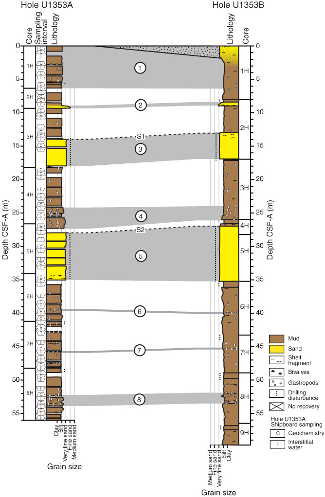
Figure F3. Tentative lithostratigraphic correlation, Holes U1353A and U1353B. Eight correlative lithostratigraphic horizons (connected with gray lines and bands) were selected based on lithology and depth: (1) Holocene dark greenish gray very fine sandy mud/muddy very fine sand (~0–6.30 m in Hole U1353A and ~0–6.40 m in Hole U1353B); (2) muddy sand with shell fragments (~8.95–9.4 m in Hole U1353A and ~8.7–8.95 m in Hole U1353B; (3) ~4 m thick well-sorted very fine sand (~13.95–17.9 m in Hole U1353A and ~12.95–16.9 m in Hole U1353B); (4) sandy mud with common occurrences of fossils, including Chlamys delicatula, Stirocolpus, and other bivalves and gastropods (~24.3–27.3 m in Hole U1353A and ~24.35–26 m in Hole U1353B); (5) 6.0–7.5 m thick well-sorted very fine sand (28.0–34.1 m in Hole U1353A and ~28.05–35.5 m in Hole U1353B); (6) shelly mud, including Stirocolpus and broken gastropods (~39.75 in Hole U1353A and ~39.85 m in Hole U1353B); (7) shelly mud, including Stirocolpus and broken gastropods (~45.7 m in Hole U1353A and ~45.2–42.35 m in Hole U1353B); (8) sandy mud with abundant fossils, including Stirocolpus, Tawera, barnacle plates, and broken shells of gastropods and bivalves (~52.20–53.6 m in Hole U1353A and ~51.95–53.70 m in Hole U1353B).
Previous | Close | Next | Top of page