Teske, A., Lizarralde, D., Höfig, T.W., and the Expedition 385 Scientists
Proceedings of the International Ocean Discovery Program Volume 385
publications.iodp.org
https://doi.org/10.14379/iodp.proc.385.202.2023
Data report: detailed lithologic columns for IODP Expedition 385 and DSDP Leg 64 sites in the Guaymas Basin, Gulf of California, Mexico1
Liselle D. Persad2 and Kathleen M. Marsaglia2
1 Persad, L.D., and Marsaglia, K.M., 2023. Data report: detailed lithologic columns for IODP Expedition 385 and DSDP Leg 64 sites in the Guaymas Basin, Gulf of California, Mexico. In Teske, A., Lizarralde, D., Höfig, T.W., and the Expedition 385 Scientists, Guaymas Basin Tectonics and Biosphere. Proceedings of the International Ocean Discovery Program, 385: College Station, TX (International Ocean Discovery Program). https://doi.org/10.14379/iodp.proc.385.202.2023
2 Department of Geological Sciences, California State University Northridge, USA. Correspondence author: kathie.marsaglia@csun.edu
Abstract
The Guaymas Basin, in the central Gulf of California, is a marginal ocean basin characterized by active seafloor spreading and high sedimentation rates. It has been the focus of two drilling expeditions, Deep Sea Drilling Project (DSDP) Leg 64 and International Ocean Discovery Program (IODP) Expedition 385. Expedition 385 recovered over 4 km of middle Pleistocene to Holocene core at eight drill sites, providing only simplistic stratigraphic columns that were broadly divided into as many as four lithostratigraphic subunits largely based on diagenetic modifications of sediments (authigenic carbonate and silica). For this study, shipboard sedimentologic descriptions of these subunits were used to create new, more detailed lithostratigraphic columns at an approximately decimeter (core) scale for correlation purposes and sedimentary interpretation. This was accomplished through examination of slabbed core images, visual core description sheets, and a shipboard lithologic database. The new columns provide more detailed downhole variability in lithology. The lithologic classification scheme for Expedition 385 was then integrated with that of sites previously drilled during Leg 64 to translate published visual core descriptions so as to uniformly generate comparable stratigraphic columns for both sets of drill holes. These newly compiled and tabulated data provide a more detailed picture of stratigraphic variation of lithology on a core by core basis across the basin.
1. Introduction and background
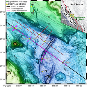
The Guaymas Basin, located in the Gulf of California, Mexico, has been the focus of two ocean drilling expeditions in the last 40 y (Figure F1). The first, Deep Sea Drilling Project (DSDP) Leg 64 in 1978, was designed to answer questions about the fundamental plate tectonic processes of continental rifting and nascent seafloor spreading (Curray, Moore, et al., 1982). Leg 64 sites in the Guaymas Basin were mainly rotary cored (Sites 477, 478, 479, and 481); only one site was piston cored (first test of this coring technique on a DSDP leg; Curray, Moore, et al., 1982). More recently, International Ocean Discovery Program (IODP) Expedition 385 (Teske et al., 2021) drilled 26 holes at 8 sites, in water depths of 1586–2001 m, with maximum penetrations of 107–540 meters below seafloor (mbsf). Expedition 385 goals included obtaining sufficient core to (1) quantify sedimentary inputs to the basin fill under varying oceanographic and climatic conditions through time, (2) study igneous sills and the hydrology and altered nature of surrounding sediment contact zones, and (3) study the distribution of subsurface microbial communities fed by alteration products (Teske et al., 2018). In contrast to Leg 64, sedimentary lithologies on Expedition 385 were cored mainly using piston coring techniques. The purpose of this study was to create uniformly formatted stratigraphic columns for each set of sites for use in postcruise studies.
Each Expedition 385 drill site (e.g., U1545) comprises two or more holes drilled at the site, which were assigned letter suffixes (A, B, C, etc.) in the order they were drilled. During this expedition, the first hole (A) was designated for the purpose of lithostratigraphic analysis, and Holes B–D were designated for geochemical and microbiological sampling and igneous rock recovery studies. For that reason, we focus on hole A at each site. As the archive halves of cores were described shipboard, lithologies were determined by visual inspection and smear slide analysis; lithologies in centimeter intervals (thicknesses) in the core were entered into a shipboard core database (DESClogik).
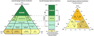
The sediment classification scheme created by shipboard sedimentologists for use during Expedition 385 was modified from previous published schemes and summarized in ternary clastic (sand/silt/clay) and ribbon biogenic classification diagrams (Figure F2). In the Expedition 385 sediment scheme, lithologies with more than 60% biogenic material and diatoms as the main components were classed as diatom oozes. The nature of the remaining 0%–40% siliciclastic components would determine the prefix lithology, such as clay-rich or silt-rich diatom oozes. In the same fashion, 40%–60% biogenic material and 40%–60% siliciclastic material would give rise to diatom clay, diatom mud, or diatom silt lithologies. The remaining 10%–40% biogenic category would be classed as siliciclastic sediments that are diatom rich. For example, the recovered sediments at Sites U1545 and U1546 are late to middle Pleistocene and consist primarily of a mix of biogenic and terrigenous components, primarily siliceous diatom oozes with clay- to silt-size siliciclastic particles, authigenic carbonate as micrite and concretions, and rare ash intervals (Teske et al., 2021).
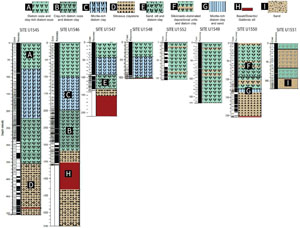
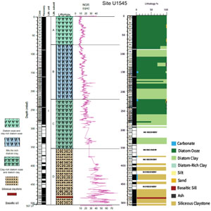
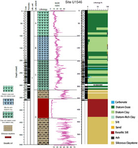
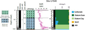
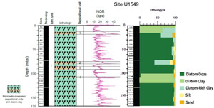
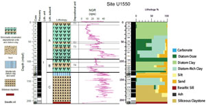
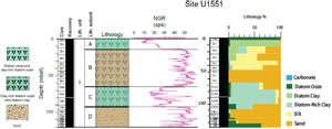
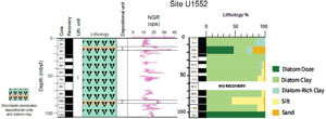
As summarized in Teske et al. (2021), Expedition 385 was a high core recovery expedition (~4 km of sedimentary units, plus significant ~200 m mafic igneous rocks). The combination of shallow-water drilling, short distances between drill sites, and high coring and recovery rates of both sediment (~4 km) and igneous rocks (~200 m) resulted in high core flow rates through the core laboratory, which diminished the sedimentologists’ ability to describe core in detail and adequately synthesize results. Core description was also significantly hampered by the small number of sedimentologists on the expedition (two per 12 h shift). The time-challenged shipboard sedimentologists were only able to create rudimentary stratigraphic columns from shipboard core descriptions for the purposes of the Expedition reports section of the volume (Figure F3; Teske et al., 2021). The main subunits were largely based on diagenetic overprinting (authigenic carbonate and silica); however, detailed lithologic information (lithology types and intervals) were entered into a DESClogik database, which is available in spreadsheet format.
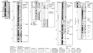
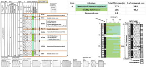
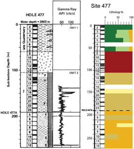
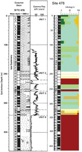
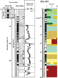
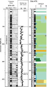
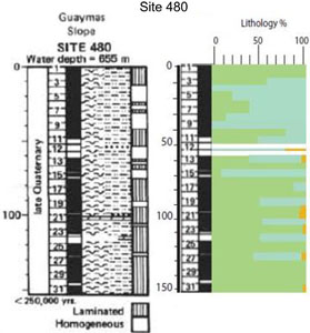
In contrast, Leg 64 summary core descriptions and lithostratigraphic columns had different formats and ways of indicating lithologies (Figure F4; Curray, Moore, et al., 1982). Leg 64 Guaymas basinal sites recovered sediments that were very late Quaternary diatom oozes and massive turbidites, intruded by basaltic and doleritic sills (Curray, Moore, et al., 1982). Leg 64 slope sites sampled varved diatomaceous sediment, including diatom oozes with thinly laminated mudstones and interbedded dolostones. Importantly, any comparison between Leg 64 and Expedition 385 site results requires that the lithologic classification schemes applied to each set of cores be consistent. This was accomplished thanks to the excellent core descriptions and smear slide data from Leg 64, as explained below.
2. Methods
Aboard the JOIDES Resolution during Expedition 385, ~4 km of sedimentary core was logged for texture and grain size (sand/silt/clay), composition (biogenic vs. clastic vs. ash), color, and gross lithology and to a lesser degree, the nature of bedding contacts and presence of sedimentary structures on a core by core basis (Teske et al., 2021). This information was recorded on 8.5 × 11 inch data sheets with high-resolution core images and then entered into the DESClogik database (note that for a few non-A holes toward the end of the expedition, data were entered directly into DESClogik because of time constraints). During preparation of Expedition research results portion of the volume (Teske et al., 2021), K. Marsaglia reviewed all visual core description sheets (VCDs) created on the cruise to ensure uniformity of description and to verify that lithologic variation was not operator related in association with shift work. This ensured uniformity of description and analysis, a critical aspect for creating enhanced stratigraphic columns for use in postcruise studies.
For our shore-based study, slabbed cores from Expedition 385 sites were analyzed remotely using the shipboard data sets (core photos, VCDs, and core description [DESClogik] data sets), with the intention of better representing detail in the lithostratigraphy and depositional history at each site. Using a normalized classification from previous literature, as well as the Expedition 385 data sets, unified stratigraphic columns were created for both Expedition 385 and Leg 64 sites. A different methodology was developed for the older DSDP sites, for which only graphic representations of core lithologies and poor quality images were available for analysis.
2.1. Construction of detailed stratigraphic columns for Expedition 385 sites
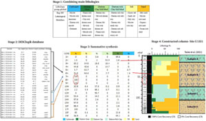
Creation of the new summary stratigraphic columns was a multistepped process. The first stage involved simplifying the nine main sedimentary lithologies described at Expedition 385 sites by combining them into six sediment groups (Figure F5). Lithologies were grouped into: (1) sand, which includes silty sand and clayey sand; (2) silt, which includes sandy silt and clayey silt; (3) diatom-rich clay, silt, or mud; (4) diatom clay, silt, or mud; (5) diatom ooze; and (6) carbonate. The sand group includes sediments containing 50% or more sand with the other 50% split between biogenic (diatom), silt, or clay material. The silt group was based on the same criteria; it includes sediments containing 50% or more silt with the next 50% split between biogenic (diatom), sand, or clay material. The diatom-rich group includes lithologies with 10%–40% biogenic material and 60%–90% siliciclastic material. The diatom clay/silt/mud groups include lithologies with 40%–60% biogenic material and 40%–60% siliciclastic material. The diatom ooze group includes lithologies with >60% biogenic material, and the carbonate group includes calcareous lithologies such as dolostone, dolomite, and limestone. Three additional minor groups were introduced to the stratigraphic columns: clay (siliceous claystone), igneous (basaltic/doleritic sill), and ash.
The second stage involved exporting the shipboard (DESClogik) database of lithology types and their intervals within the cores into Microsoft Excel spreadsheets for each site (Figure F5). Thicknesses of lithologies recovered in each core were tallied for each of the six sediment groups (Figure F5). These were then summarized per core based on VCDs and verified by visually examining shipboard core images accessed via the IODP LIMS Reports web page (https://web.iodp.tamu.edu/LORE).
The third stage involved compiling and tabulating the data on a core by core basis in a newly created spreadsheet (see LITH in Supplementary material). The lithologies were summed for an individual core and lithology proportions of the six sedimentary (plus three other) groups were calculated as a percentage of the recovered material to produce a more detailed picture of stratigraphic variation. Per standard IODP practice, recovered core segments within each 9.5 m core interval were pushed to the top, which means gaps in recovery can be cryptic unless represented by abrupt lithologic changes across a segment gap.
Using the sediment classification scheme and data from the DESClogik database, the fourth stage involved the creation of uniformly generated stratigraphic columns using Adobe Illustrator to depict lithology proportions in each core interval (Figure F5).
2.2. Construction of detailed stratigraphic columns for DSDP Leg 64 sites
Similarly formatted lithostratigraphic columns were generated for the Leg 64 sites (Figure F6) to compare and integrate them with the Expedition 385 drilling results. This required that the lithologic classification schemes applied to the cores be consistent between the two sets.
First, the sediment classification scheme for both expeditions had to be compared, and in the case of Leg 64, simplified and normalized to fit the Expedition 385 scheme (Figure F2). The excellent core descriptions and smear slide data from Leg 64 provided enough information on the individual Core Description Forms to translate and generate column data consistent with that generated for Expedition 385 sites (Figure F6).
Lithologies were grouped: (1) sand, which includes silty sand and clayey sand; (2) silt, which includes sandy silt and clayey silt; (3) diatom-rich clay, silt, or mud; (4) diatom clay, silt, or mud; (5) diatom ooze; and (6) carbonate. The Expedition 385 diatom-rich group was translated to the Leg 64 group that described lithologies with 10%–40% biogenic/60%–90% siliciclastic materials as being diatomaceous mud (30%–40% biogenic/diatoms), diatomaceous clay/silty clay, and diatomaceous silt/clayey silt (10%–30% biogenic/diatoms), with the remaining percent as siliciclastic material. The Expedition 385 diatom clay/silt/mud group was translated to the Leg 64 group that described lithologies with 40%–60% diatoms as muddy diatom ooze, silty diatom ooze (silty diatomite in hard rock form), and clayey diatom ooze (clayey diatomite in hard rock form). The same percent criteria and translation were used for the diatom ooze and carbonate groups as well as the three additional clay, ash, and igneous groups. Note that probable protolith lithologies were used in intervals affected by contact metamorphism or hydrothermal alteration.
The Expedition 385 methodology described in the previous section was then used to translate and create uniformly formatted stratigraphic columns for the Leg 64 sites.
3. Results
3.1. Revised lithostratigraphic columns for Expedition 385 sites
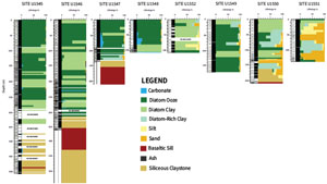
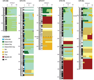
Using the simplified method of grouped lithologies in Figure F5, the total interval thickness for each group was summed and the percentages were calculated for each core in each Hole A at all Expedition 385 sites (see LITH in Supplementary material). Stratigraphic columns ranging up to approximately 500 m in length were constructed for each of the eight Expedition 385 sites (Figure F7). The columns display relative proportions of the lithology groups in stacked histogram fashion. Overall, high recovery rates produced fairly continuous stratigraphic representation for each hole, but a recovery rate column was added to provide context for any given core.
Each of the new detailed columns is presented next to its shipboard equivalent column in Figures F8, F9, F10, F11, F12, F13, F14, and F15. The shipboard columns show the lithostratigraphic units/subunits determined shipboard based on lithology and diagenetic modification. The greater lithologic detail provided in the columns constructed as part of this study provide new insights for each site (Table T1).
3.2. Revised lithostratigraphic columns for DSDP Leg 64 sites
The Leg 64 format (at a core scale) is translated using the Expedition 385 methodology despite the lower recovery rates and drilling disturbances (see LITH in Supplementary material) and unified classification scheme described above (Figure F2). The resulting columns created for this study (Figure F16) show very similar stratigraphy and sedimentary facies to Expedition 385 sites (Figure F7), despite differences in coring techniques and recovery rates. Each of the new detailed columns is presented next to its shipboard equivalent column in Figures F17, F18, F19, F20, and F21. The greater lithologic detail provided in the columns constructed as part of this study is laid out in Table T2.
3.3. Comments
Examples of new observations (Tables T1, T2) include (1) the greater lithologic detail in all columns; (2) new details in the transitions between lithologies (abrupt between cores or within a core versus gradational across several cores); and (3) the ability to show percentages of minor lithologies, such as carbonate, sand, or within the core. The greater detail presented in the new columns also suggests that location of some subunit boundaries could be modified to include the lithologies observed in the cores or eliminated because there is no major lithologic basis (e.g., only traces of micrite).
4. Acknowledgments
Funding for this study was provided by grants to Kathleen Marsaglia from the IODP US Science Support Program and the National Science Foundation (OCE-2133396). This study used data provided by the International Ocean Discovery Program. We thank the IODP Expedition 385 shipboard scientists, particularly shipboard sedimentologists Ivano Aiello, Martine Bautier, and Swanne Gontharet, for their contributions to the database that made this study possible. Similarly, we acknowledge the excellent detailed work by the DSDP Leg 64 shipboard sedimentologists, Eduardo Aguayo, Gerhard Einsele, Kerry Kelts, and Jeffrey Niemitz. Our sincere thanks go to reviewer Kitty Milliken.
References
Curray, J.R., Moore, D.G., et al., 1982. Initial Reports of the Deep Sea Drilling Project, 64: Washington, DC (US Government Printing Office).
https://doi.org/
Persad, L.D., and Marsaglia, K.M., 2023. Supplementary material, https://doi.org/
Teske, A., Lizarralde, D., and Höfig, T.W., 2018. Expedition 385 Scientific Prospectus: Guaymas Basin Tectonics and Biosphere, International Ocean Discovery Program. https://doi.org/
Teske, A., Lizarralde, D., Höfig, T.W., Aiello, I.W., Ash, J.L., Bojanova, D.P., Buatier, M.D., Edgcomb, V.P., Galerne, C.Y., Gontharet, S., Heuer, V.B., Jiang, S., Kars, M.A.C., Khogenkumar Singh, S., Kim, J.-H., Koornneef, L.M.T., Marsaglia, K.M., Meyer, N.R., Morono, Y., Negrete-Aranda, R., Neumann, F., Pastor, L.C., Peña-Salinas, M.E., Pérez Cruz, L.L., Ran, L., Riboulleau, A., Sarao, J.A., Schubert, F., Stock, J.M., Toffin, L.M.A.A., Xie, W., Yamanaka, T., and Zhuang, G., 2021. Expedition 385 summary. In Teske, A., Lizarralde, D., Höfig, T.W., and the Expedition 385 Scientists, Guaymas Basin Tectonics and Biosphere. Proceedings of the International Ocean Discovery Program, 385: College Station, TX (International Ocean Discovery Program). https://doi.org/
