Hodell, D.A., Abrantes, F., Alvarez Zarikian, C.A., and the Expedition 397 Scientists
Proceedings of the International Ocean Discovery Program Volume 397
publications.iodp.org
https://doi.org/10.14379/iodp.proc.397.202.2025
Data report: an improved splice using XRF data, IODP Expedition 397 Site U15861
F. Abrantes,2, 3, 4 V. Magalhães,3, 5 D.A. Hodell,2 T.D. Herbert,2 M. Alonso-Garcia,4, 6 M. Castaño,4 F. Ferreira,4 M. Freitas,3 L. Gebara,3, 4 I. Gil,3, 4 M. Gonzáles-Martín,6 A. Lopes,3 C. Lopes,3, 4 L. Matos,3, 4 A. Mega,4 G. Molina,4 F. Naughton,3, 4 D. Oliveira,4 A. Rebotim,4 T. Rodrigues,3, 4 E. Salgueiro,2, 3, 4 A. Santana,4 R. Treyos-Tamayo,6 C.A. Alvarez Zarikian,2 and the Expedition 397 Scientists2
1 Abrantes, F., Magalhães, V., Hodell, D.A., Herbert, T.D., Alonso-Garcia, M., Castaño, M., Ferreira, F., Freitas, M., Gebara, L., Gil, I., Gonzáles-Martín, M., Lopes, A., Lopes, C., Matos, L., Mega, A., Molina, G., Naughton, F., Oliveira, D., Rebotim, A., Rodrigues, T., Salgueiro, E., Santana, A., Treyos-Tamayo, R., Alvarez Zarikian, C.A., and the Expedition 397 Scientists, 2025. Data report: an improved splice using XRF data, IODP Expedition 397 Site U1586. In Hodell, D.A., Abrantes, F., Alvarez Zarikian, C.A., and the Expedition 397 Scientists, Iberian Margin Paleoclimate. Proceedings of the International Ocean Discovery Program, 397: College Station, TX (International Ocean Discovery Program). https://doi.org/10.14379/iodp.proc.397.202.2025
2 Expedition 397 Scientists’ affiliations. Correspondence author: [email protected]
3 Divisão de Geologia e Georecursos Marinhos, Instituto Português do Mar e da Atmosfera (IPMA), Portugal.
4 Centro de Ciências do Mar (CCMAR), Universidade do Algarve, Portugal.
5 Instituto Dom Luiz (IDL), Faculdade de Ciências da Universidade de Lisboa, Portugal.
6 Department of Geology, University of Salamanca, Spain.
Abstract
During International Ocean Discovery Program Expedition 397, four sites (U1586, U1587, U1385, and U1588) were drilled in the Promontório dos Príncipes de Avis, a plateau located on the Portuguese continental slope that is elevated above the Tagus Abyssal Plain and isolated from the influence of turbidites. The drilled sites are arranged along a bathymetric transect (4692, 3479, 2591, and 1339 meters below sea level, respectively) to intersect the significant subsurface water masses of the eastern North Atlantic. Multiple holes were drilled at each site to ensure a complete spliced composite sequence. Postcruise X-ray fluorescence core scanning was done to refine the shipboard stratigraphic splice. Using Ca/Ti, it was possible to enhance the Site U1586 splice and establish the new core composite depth below seafloor, Method A (CCSF-A), for each hole (U1586A–U1586D).
1. Introduction
The main purpose of International Ocean Discovery Program (IODP) Expedition 397 was to drill in the Promontório dos Príncipes de Avis at four sites located along a bathymetric transect (4692, 3479, 2591, and 1339 meters below sea level [mbsl]) to intersect each of the essential subsurface water masses of the eastern North Atlantic (Figure F1).
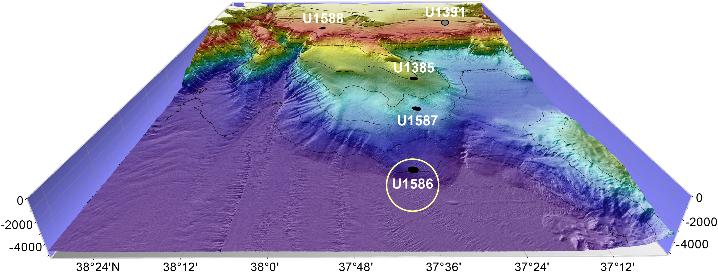
Figure F1. Depth distribution of Expedition 397 sites.
The primary objective of Site U1586, the deepest (4692 mbsl) and farthest site from shore, was to recover a deep distal record from the Lower Deep Water, which consists of Antarctic Bottom Water significantly modified from its origin in the high-latitude South Atlantic. A 350 m sequence was recovered in four holes that extend as far back as the Middle Miocene (14 Ma). Sedimentation rates average 5 cm/ky in the Quaternary, the lowest of all the Expedition 397 sites. Furthermore, a few slumped intervals were encountered in the stratigraphic sequence. Despite these limitations, Site U1586 anchors the deep end-member of the bathymetric transect and provides an important reference section to study deepwater circulation in the deep Northeast Atlantic. The study of such records should permit the reconstruction of changes in ventilation and carbon storage in the deepest Atlantic on glacial–interglacial and millennial timescales with potential implications for atmospheric CO2 changes. Additionally, its record shall provide a history of surface and deepwater conditions through the Pliocene, including the mid-Pliocene warm period, when atmospheric CO2 was like modern times (400 ppm) (Dowsett et al., 2013). Sediments recovered at Site U1586 will also help study how surface and deep oceanographic conditions responded to the intensification of Northern Hemisphere glaciation in the late Pliocene (~2.9 Ma) (Raymo, 1994; Maslin et al., 1998). We recovered much older sediment (14 Ma) than anticipated, extending the expedition objectives to the Middle Miocene. In combination with Site U1587, these records will bring new critical insight into the understanding of the causes and consequences of the Messinian Salinity Crisis and the interruption of the water exchange between the Atlantic-Mediterranean through the Gibraltar Strait gateway (Hsü et al., 1973).
Stratigraphic correlation of the four holes at Site U1586 (U1586A–U1586D) was established aboard the ship using the Correlator software. Magnetic susceptibility (MS) from the Whole-Round Multisensor Logger (WRMSL) and natural gamma radiation (NGR) were used to define the tie points. Using multiple holes allowed the definition of a ~378 m core composite depth below seafloor, Method A (CCSF-A), with complete overlap and only one potential small gap in the Upper Pliocene where the overlap is equivocal. However, to allow for intercore and global comparison of the many proxy data that will be produced, it is fundamental that the respective sites’ splice is as precise as possible so that an accurate age model can be established. We follow Hodell et al. (2015, 2023), who demonstrated that the use of X-ray fluorescence (XRF) data correction of the Expedition 339 Site U1385 onboard splice was crucial for the subsequent age model definition using the benthic foraminifer oxygen isotope record, a methodology that has been subjected to extensive verification. To complete XRF analysis of all the cores used in the shipboard splices of Expedition 397 sites, we decided to use laboratories that, similar to the Texas A&M University and Bremen core repositories, are equipped with AvaaTech XRF machines (https://www.avaatech.com/corescanner/xrf-core-scanner-upgrades). Furthermore, to guarantee the consistency of measurements throughout each site, complete sites were allocated to one of the four different laboratories (Site U1587 to the Gulf Coast Repository [USA]; Site U1588 to the Bremen Core Repository [Germany]; Site U1385 to the Godwin Laboratory at Cambridge University [UK]; Site U1586 to the EMSO-GOLD laboratory of the Portuguese Institute for Sea and Atmosphere [IPMA] [Portugal]. This manuscript reports on the method applied to improve the shipboard splice for Site U1586 using XRF data.
2. Methods and materials
Site U1586 was recovered during IODP Expedition 397 off southwest Iberia. Located at 37°37.3108′N, 10°42.5987′W, at 4692 mbsl, it was the deepest and farthest site from shore (170 km) drilled during the expedition. Four holes were drilled (U1586A–U1586D), and they recovered 350 meters of sediment (core depth below seafloor, Method A [CSF-A], depth scale). Downhole logging extended from ~100 to ~223 m CSF-A, but because of the relatively low sedimentation rate at Site U1586 (~5 cm/ky), the scale of lithologic cyclicity needed to correlate accurately to physical property measurements was not captured, and thus downhole logging did not add important constraints to the generation of the Site U1586 composite. The final correlation between holes, established using MS from the WRMSL and NGR, resulted in a composite section of ~378 m CCSF-A (Abrantes et al., 2024).
XRF analysis was performed at the EMSO-GOLD laboratories of the Divisão de Geologia e Georecursos Marinhos of IPMA (https://emso-gold.ipma.pt) using a 4th-generation Avaatech XRF core scanner (https://www.avaatech.com).
Analysis was done on the archive halves after the core sediment surface was carefully scraped with a glass blade to remove any possible contamination and smooth out surface irregularities. Cores were then immediately covered with a 4 µm thick Cole-Parmer Ultralene film to minimize desiccation and prevent cross-contamination when the equipment’s prism purged the sediment surface with He contacts.
The AvaaTech XRF core scanner permits the analyses of the entire suite of elements between Magnesium (Mg) and Uranium (U). Measurements were done at 1 cm intervals with each measurement corresponding to the integration of an irradiated surface area of 12 mm (cross core) × 5 mm (along core). Three excitation voltages were employed: 10 kV, 0.3 mA (no filter); 30 kV, 0.2 mA (with a thin palladium filter); and 50 kV, 1 mA (with a copper filter). Count times were between 10 and 20 s. Data were processed, and the element abundances were quantified using the BRIGHTSPEC bAxil software.
The need to have an improved splice by the end of April 2023 to better plan the sampling party that took place in June 2023 led to the strategy of first measuring all the cores used in the shipboard splice at 10 kV (20 s) and 30 kV (20 s). All the remaining sections of the four holes were only measured at 10 kV (10 s). This data acquisition time (10 s) was enough to obtain good signal-to-noise ratios for the 10 kV peaks quantification. This decision was based not only on the available time, but also upon consideration that the 10 kV measurements would provide the means of correlating all nonsplice sections to the shipboard splice. After completing the initial run and recognizing the interest in providing Ba data to the scientific party, the cores used for the onboard splice were rerun at 50 kV. Measurements were complete in November 2023.
Ca/Ti was used to improve the shipboard splice, which was accomplished using Correlator software (Version 4.0.1).
3. Results
A combination of dating methods regularly fulfills the unavoidable need for a precise age model before any reconstruction of past conditions. For Pleistocene sediments, a correlation of the benthic foraminifer oxygen isotopic records to the LR04 δ18O stack published by Lisiecki and Raymo (2005) is the most usual dating method. The existence of a well-established and robust chronology based on benthic δ18O for Site 339 U1385, as well as a Ca/Ti signal that reveals a clear correspondence to the planktonic δ18O record (Hodell et al., 2015, 2023), led us to elect Ca/Ti as the parameter to correlate all the sites.
The Ca/Ti measured along the sections that compose the shipboard splice of Site U1586 revealed the existence of overlaps, offsets, and gaps. Inadequacies in the shipboard splice (Splice 13) were further confirmed by consulting revised splices for Sites 339 U1385 and U1587 for stratigraphic consistency in chronologically correlative intervals and consulting core photographs and shipboard descriptions to avoid disturbed intervals from the final splice as much as possible.
Minor adjustments to the shipboard splice were made to take advantage of the high signal-to-noise ration of the XRF data for correlation. In most cases, tie points used by the shipboard party were shifted on the order of 5–20 cm so that local maxima or minima in Ca/Ti could be matched. We checked the reliability of the shipboard splice using XRF and physical property measurements to do orbital-scale correlations to the Pleistocene and Pliocene at Sites U1385 and U1587 and additionally to the pre-Messinian sequence at Site U1587 (because of slumping, correlating the late Miocene at Site U1586 to Site U1587 is not possible). Except for a handful of slumps in the Pleistocene and latest Pliocene at Site U1586, a cycle-for-cycle correlation to other Expedition 397 holes is achieved with the present composite section.
To reach high precision in tying XRF data between holes, we used a Gaussian Process (GP) regression procedure to smooth the raw data and obtain the most reliable tie points. GP is increasingly used in many scientific domains to smooth and interpolate data that contain errors (e.g., all data). It has the benefit of adapting to the covariance of the data and is therefore superior to an arbitrary choice of a smoothing function such as moving window smoothing (boxcar, Gaussian, etc.) and the length of the smoothing function. GP regression also provides uncertainty estimates of the most likely values based on the data covariance. We used code available from the GPy Python library (https://gpy.readthedocs.io/en/deploy/GPy.core.html) with the sum of RBF and Matern32 kernels as the covariance kernel to obtain the most likely values of Ca and Ti from XRF scans.
More significant revisions to the shipboard splice were made in the Miocene sections. This interval has very large high frequency changes in carbonate content that behave differently mechanically upon XCB coring, resulting in significant distortion when offset profiles of the equivalent sections are compared. A careful examination showed several instances where the shipboard splicing was incorrect. We also endeavored to choose the least distorted (by comparison of multiple profiles) representation of the sedimentary sequence in the final composite. Specifically, the shipboard splice connecting Core 397-U1586D-24X to the underlying Core 397-U1586C-26X was revised in the final splice to tie Core 397-U1586D-24X to the underlying Core 397-U1586B-26X, the splice from Core 397-U1586B-28X to Core 397-U1586A-32X was revised to splice Core 397-U1586B-28X to Core 397-U1586C-28X, and the splice below Core 397-U1586B-31X was largely replaced in the new splice with the goal of reducing coring distortion and correcting several errors in the shipboard composite. Three intervals were appended because no overlap could be documented between offset sections based on XRF or other high-resolution stratigraphic information. The splice from Cores 397-U1586D-22X to 23X coincides with an interval of poor recovery in the offset holes that coincided with a slumped zone. Cores 397-U1586B-39X and 40X lie in the shallow water basal section of the sequence and could not be correlated to offset holes with confidence. Each interval between appended sections should be regarded as a potential gap in the splice. To fill in the gaps and, in some cases, pinpoint the extension of some overlaps, measurements of adjoining core sections were used to determine the correction to be applied to the CCSF-A depth scale.
Figure F2 shows an example of the obtained Ca/Ti record for the Site U1586 shipboard splice and its comparison to the CCSF-A depth scale generated by the final accepted splice designated by the revised splice (Splice 19). Table T1 reports the new revised splice, and Table T2 contains the corresponding affine table (Affine 19) for Holes U1586A–U1586D. The Ca/Ti data for the revised splice is presented in SPLICE in Supplementary material.
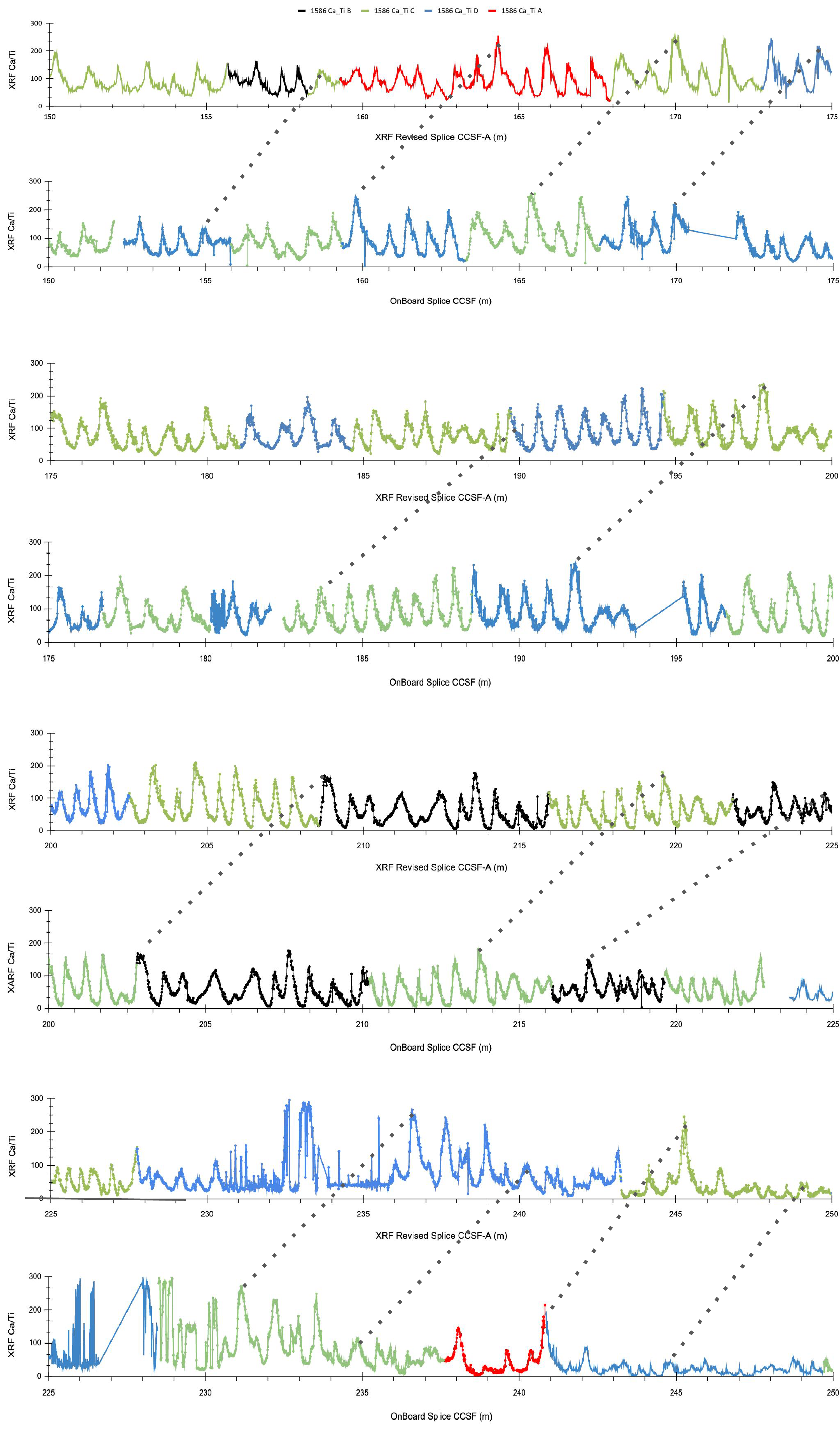
Figure F2. Ca/Ti shipboard splice vs. XRF revised splice.
4. Acknowledgments
The authors acknowledge IODP for allowing the analysis of the cores from Holes U1586A–U1586D in Lisbon. The study took place at the EMSO-GOLD laboratories of IPMA-Algés without specific funding and was only possible through the effort and enthusiasm of the entire paleoclimate group, who worked an extra 4 h shift every week between 6 January and 22 November 2023. The necessary consumables (gas, film, etc.) were supported by CCMAR (FCT projects UIDB/04326/2020, UIDP/04326/2020, and LA/P/0101/2020).
References
Abrantes, F., Hodell, D.A., Alvarez Zarikian, C.A., Brooks, H.L., Clark, W.B., Dauchy-Tric, L.F.B., dos Santos Rocha, V., Flores, J.-A., Herbert, T.D., Hines, S.K.V., Huang, H.-H.M., Ikeda, H., Kaboth-Bahr, S., Kuroda, J., Link, J.M., McManus, J.F., Mitsunaga, B.A., Nana Yobo, L., Pallone, C.T., Pang, X., Peral, M.Y., Salgueiro, E., Sanchez, S., Verma, K., Wu, J., Xuan, C., and Yu, J., 2024. Site U1586. In Hodell, D.A., Abrantes, F., Alvarez Zarikian, C.A., and the Expedition 397 Scientists, Iberian Margin Paleoclimate. Proceedings of the International Ocean Discovery Program, 397: College Station, TX (International Ocean Discovery Program). https://doi.org/10.14379/iodp.proc.397.103.2024
Abrantes, F., Magalhães, V., Hodell, D.A., Herbert, T.D., Alonso-Garcia, M., Castaño, M., Ferreira, F., Freitas, M., Gebara, L., Gil, I., Gonzáles-Martín, M., Lopes, A., Lopes, C., Matos, L., Mega, A., Molina, G., Naughton, F., Oliveira, D., Rebotim, A., Rodrigues, T., Salgueiro, E., Santana, A., Treyos-Tamayo, R., Alvarez Zarikian, C.A., and the Expedition 397 Scientists, 2025. Supplementary material, https://doi.org/10.14379/iodp.proc.397.202supp.2025. In Abrantes, F., Magalhães, V., Hodell, D.A., Herbert, T.D., Alonso-Garcia, M., Castaño, M., Ferreira, F., Freitas, M., Gebara, L., Gil, I., Gonzáles-Martín, M., Lopes, A., Lopes, C., Matos, L., Mega, A., Molina, G., Naughton, F., Oliveira, D., Rebotim, A., Rodrigues, T., Salgueiro, E., Santana, A., Treyos-Tamayo, R., Alvarez Zarikian, C.A., and the Expedition 397 Scientists, Data report: an improved splice using XRF data, IODP Expedition 397 Site U1586. In Hodell, D.A., Abrantes, F., Alvarez Zarikian, C.A., and the Expedition 397 Scientists, Iberian Margin Paleoclimate. Proceedings of the International Ocean Discovery Program, 397: College Station, TX (International Ocean Discovery Program).
Dowsett, H.J., Foley, K.M., Stoll, D.K., Chandler, M.A., Sohl, L.E., Bentsen, M., Otto-Bliesner, B.L., Bragg, F.J., Chan, W.-L., Contoux, C., Dolan, A.M., Haywood, A.M., Jonas, J.A., Jost, A., Kamae, Y., Lohmann, G., Lunt, D.J., Nisancioglu, K.H., Abe-Ouchi, A., Ramstein, G., Riesselman, C.R., Robinson, M.M., Rosenbloom, N.A., Salzmann, U., Stepanek, C., Strother, S.L., Ueda, H., Yan, Q., and Zhang, Z., 2013. Sea surface temperature of the mid-Piacenzian ocean: a data-model comparison. Scientific Reports, 3(1):2013. https://doi.org/10.1038/srep02013
Hodell, D., Lourens, L., Crowhurst, S., Konijnendijk, T., Tjallingii, R., Jiménez-Espejo, F., Skinner, L., Tzedakis, P.C., and the Shackleton Site Project Members, 2015. A reference time scale for Site U1385 (Shackleton Site) on the SW Iberian Margin. Global and Planetary Change, 133:49–64. https://doi.org/10.1016/j.gloplacha.2015.07.002
Hodell, D.A., Crowhurst, S.J., Lourens, L., Margari, V., Nicolson, J., Rolfe, J.E., Skinner, L.C., Thomas, N.C., Tzedakis, P.C., Mleneck-Vautravers, M.J., and Wolff, E.W., 2023. A 1.5-million-year record of orbital and millennial climate variability in the North Atlantic. Climate of the Past, 19(3):607–636. https://doi.org/10.5194/cp-19-607-2023
Hsü, K.J., Ryan, W.B.F., and Cita, M.B., 1973. Late Miocene desiccation of the Mediterranean. Nature, 242(5395):240–244. https://doi.org/10.1038/242240a0
Lisiecki, L.E., and Raymo, M.E., 2005. A Pliocene-Pleistocene stack of 57 globally distributed benthic δ18O records. Paleoceanography, 20(1):PA1003. https://doi.org/10.1029/2004PA001071
Maslin, M.A., Li, X.S., Loutre, M.F., and Berger, A., 1998. The contribution of orbital forcing to the progressive intensification of Northern Hemisphere glaciation. Quaternary Science Reviews, 17(4–5):411–426.
Raymo, M.E., 1994. The initiation of Northern Hemisphere glaciation. Annual Review of Earth and Planetary Sciences, 22:353–383. https://doi.org/10.1146/annurev.ea.22.050194.002033
Stow, D.A.V., Hernández-Molina, F.J., Alvarez Zarikian, C.A., and the Expedition 339 Scientists, 2013. Proceedings of the Integrated Ocean Drilling Program, 339: Tokyo (Integrated Ocean Drilling Program Management International, Inc.). https://doi.org/10.2204/iodp.proc.339.2013