Data report: revised Pleistocene sediment splice for Site U1457
PDF Download figures Download table Cited by
Pandey, D.K., Clift, P.D., Kulhanek, D.K., and the Expedition 355 Scientists
Proceedings of the International Ocean Discovery Program Volume 355
publications.iodp.org

https://doi.org/10.14379/iodp.proc.355.202.2019
Data report: revised Pleistocene sediment splice for Site U1457, IODP Expedition 3551
Mitchell Lyle,2 and Rajeev Saraswat3
Keywords: International Ocean Discovery Program, IODP, JOIDES Resolution, Expedition 355, Arabian Sea Monsoon, Site U1457, Laxmi Basin, stratigraphic correlation, sampling splice
MS 355-202: Received 10 May 2018 · Accepted 11 October 2018 · Published 1 February 2019
Abstract
Sediment cores from adjacent holes at a drill site are typically spliced to make a continuous sediment record that spans sediment gaps that occur between sediment cores within each hole. The splice also provides a template for later sampling. During International Ocean Discovery Program Expedition 355, we made such a splice for both Sites U1456 and U1457 using shipboard Whole-Round Multisensor Logger and Section Half Multisensor Logger data. The shipboard-spliced sediment section at Site U1457 was constructed for the advanced piston corer interval to an age of about 1.5 Ma. Additional postexpedition planktonic foraminifer stable isotope data (Globigerinoides ruber δ18O) show that the shipboard stratigraphic tie between Cores 355-U1457B-1H and 355-U1457A-1H was wrong. This paper describes a revised splice that appends Core 355-U1457A-1H to the base of Core 355-U1457B-1H. The core composite depth below seafloor depths of the remaining splice have been revised because of this change. The revised splice interval is also longer by 1.2 m to accommodate the lower part of Core 355-U1457B-1H. In addition, a break of unknown thickness is present between Cores 355-U1457B-1H and 355-U1457A-1H. The revised splice interval table is included in this report.
Introduction
Site U1457 was drilled in the Laxmi Basin, eastern Arabian Sea, as part of the International Ocean Discovery Program (IODP) Expedition 355 study of sedimentation and Himalayan climate change (Figure F1) (Pandey et al., 2016a). Three holes were drilled at Site U1457, one from 0 to 144.8 m core depth below seafloor, method A (CSF-A) (Hole U1457A) and a second from 0 to 204.7 m CSF-A (Hole U1457B). Hole U1457C was drilled without coring to 191.6 m CSF-A and drilled to 1108 m CSF-A. Holes U1457A and U1457B used the standard advanced piston corer (APC) to about 110 m CSF-A, coring such that core tops were offset in order to build a continuous sediment section spliced from cores in both holes. This continuous section is often referred to as the sampling splice or simply as the sediment splice. A continuous sediment section splicing Holes U1457A and U1457B was constructed on board the JOIDES Resolution during Expedition 355. In this paper, we revise the Site U1457 splice in light of new data from stable oxygen isotope studies (Saraswat et al., submitted) that allowed us to identify an additional sediment section to include in the splice and a coring gap near the top of the section.
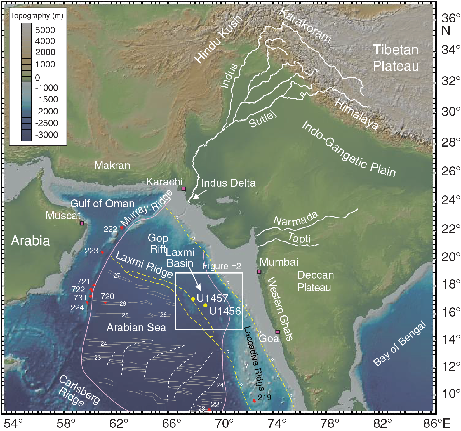
Figure F1. Bathymetric map of the Arabian Sea showing the location of Site U1457.
The coring plan for Holes U1457A and U1457B reflects long experience with coring to collect continuous sediment sections. When hydraulic piston coring was introduced during the Deep Sea Drilling Project, it was quickly discovered that there were often gaps of ~0.5 m in the sedimentary section between each core (Heath et al., 1985; Ruddiman et al., 1987). A protocol to make a complete and continuous sediment section from multiple holes was developed by matching stratigraphic features in adjacent holes to build a composite depth scale so that stratigraphic features in different holes were located at the same composite depth. A continuous sediment section was then spliced together by extracting and concatenating sections from adjacent holes across coring gaps. Typically, three holes are drilled to ensure that all core gaps have been sampled and a continuous splice can be made (Hagelberg et al., 1995, and references therein).
The continuous sediment splice was developed not only to reassemble a complete sediment lithostratigraphic section but also so that investigators could sample the continuous section for further work. The matches between adjacent holes are created using shipboard physical property data to identify common stratigraphic features and then offsetting depths in individual cores. Shifting the depth of each individual core in the CSF-A depth scale until marker stratigraphic features align forms the common composite depth framework (core composite depth below seafloor [CCSF]).
Results: revision of the Site U1457 sediment sampling splice
Magnetic susceptibility, gamma ray attenuation (GRA) bulk density, and natural gamma radiation (NGR) core logging measurements were used along with line-scan red-green-blue (RGB) color data to correlate the sediment sections and find marker stratigraphic horizons during Expedition 355, as shown in Figure F2 (also see Figure F17 in the Site U1457 chapter [Pandey et al., 2016b]), which shows the splice constructed during the expedition by picking horizons between cores where the stratigraphy matched and then combining them into a continuous sedimentary record. In Figure F2, a blue vertical line marks the base of the sediment section included in the splice from a particular core that is then joined to a correlative horizon marked by a yellow line in the adjacent hole to make the splice. The yellow line thus marks the top of the splice in the adjacent hole. Shown on Figure F2 are the compressed core images and the magnetic susceptibility record from each hole, as well as the spliced core composite image and spliced magnetic susceptibility record (top). The images are offset to the CCSF depth scale.
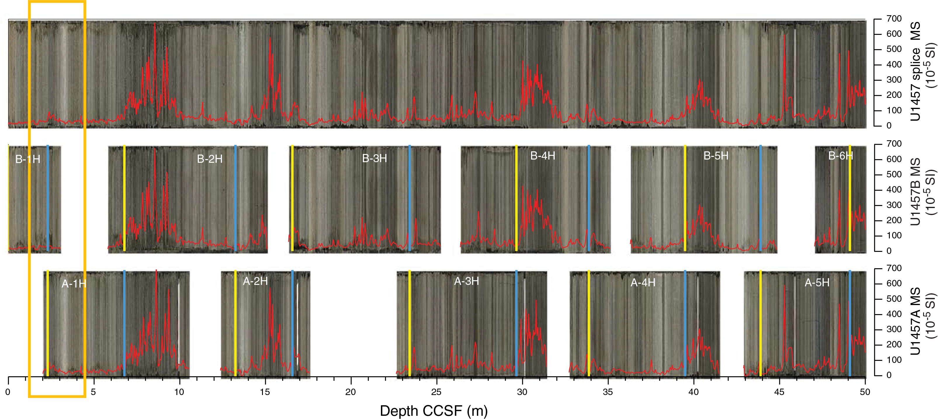
Figure F2. Shipboard sampling splice from Site U1457.
The splice suffered from a weak tie at the very top of the splice interval, as noted by the stratigraphic correlators (see Table T11 in Pandey et al., 2016b). Although Core 355-U1457A-1H recovered less than 9.5 m of sediment and at the time was assumed to have recovered the sediment/water interface, comparison to the uppermost core from the subsequent hole (U1457B) indicated that the sediment/water interface was missing from Core 355-U1457A-1H and that coring had initiated below the topmost sediments. Core 355-U1457B-1H, from the second hole, was short (3.22 m), and it was unclear from any of the core logging data whether the base of Core 355-U1457B-1H actually overlapped the top of Core 355-U1457A-1H. A tie was assigned between the two at a minor peak in magnetic susceptibility, at a depth of 2.01 m CCSF, but the tie (Figure F2; outlined by the orange box) was marked to be suspect. The magnetic susceptibility, although low, did not match very well at the tie.
New data collected since the end of IODP Expedition 355 makes it clear that the suspect tie between Cores 355-U1457B-1H and 355-U1457A-1H was wrong. The sediment sections of the two cores do not actually overlap. Figure F3 shows postexpedition stable isotope data from the planktonic foraminifer Globigerinoides ruber (Saraswat et al., submitted) on the revised sampling splice. The δ18O data from Core 355-U1457B-1H ends at the original tie point to Core 355-U1457A-1H. There is a clear offset of 1.4‰ in the δ18O data between the end of the Core 355-U1457B-1H section and the top of the Core 355-U1457A-1H section, which is well above any possibility of measurement error. The isotope data overlap in the original shipboard splice (2.44 m CCSF for the last sample from Core 355-U1457B-1H versus 2.10 m CCSF for the topmost sample from Core 355-U1457A-1H). Values for all three of the overlapping isotope samples are offset, so there is a clear mismatch of data. A revision of the splice was necessary.
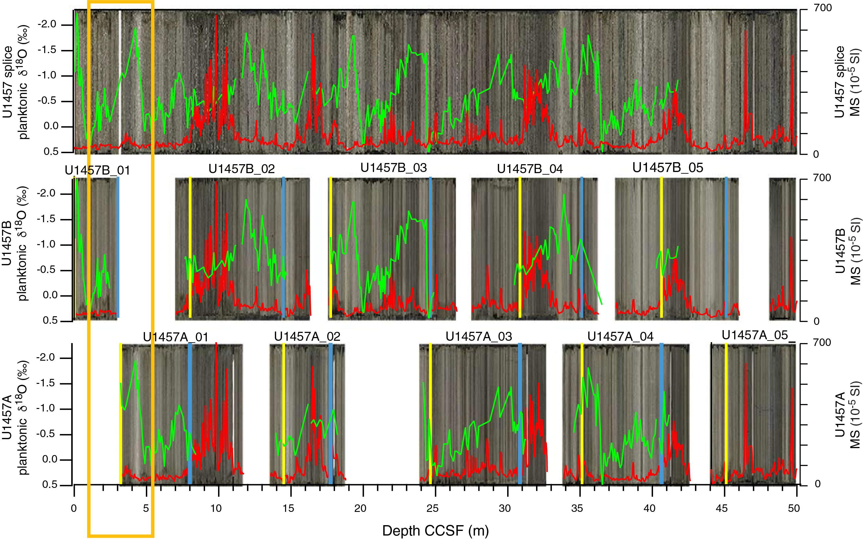
Figure F3. Revised Site U1457 sediment splice.
We reexamined the shipboard core logging data and images to identify if there was another potential horizon near the base of Core 355-U1457B-1H that could tie with Core 355-U1457A-1H. The δ18O value at 4.24 m CCSF in Core 355-U1457A-1H does nearly match the value at 0.19 m CCSF in Core 355-U1457B-1H, but that results from the 100 ky cyclicity of the Pleistocene δ18O record. The color record clearly does not match because the small brown interval at the top of Core 355-U1457B-1H is missing and there are small but clear offsets in the other Whole-Round Multisensor Logger WRMSL records.
Because we could identify no unambiguous tie between the two cores, we elected to append Core 355-U1457A-1H to the base of Core 355-U1457B-1H. The net effect is to lengthen the total splice interval by 1.2 m to accommodate the remainder of Core 355-U1457B-1H, including the core catcher (CC) section. In addition, there is also a missing section of indeterminate length between cores, but it probably measures between 0 and 1 m, based on typical coring gaps (Ruddiman et al., 1987). The revised splice interval table is listed in Table T1 and also can be downloaded from the IODP Laboratory Information Management System (LIMS) database (http://web.iodp.tamu.edu/LORE) for Site U1457.
Acknowledgments
This research used samples and data provided by the International Ocean Discovery Program. We thank IODP Expedition 355 science party members and IODP for all the effort to properly collect and archive the Site U1457 sediment cores. We also thank Dr. Roy Wilkens for his review of the manuscript. A US Science Support Program (USSSP) Post Expedition Award to ML was used to review and revise the Expedition 355 splices. RS is thankful to the National Center for Antarctic and Ocean Research for providing postcruise funding. Authors thankfully acknowledge the help of Professor Andreas Mackensen, Alfred Wegener Institute for Polar and Marine Research, Bremerhaven, Germany, in analyzing stable oxygen isotopic ratios.
References
Hagelberg, T.K., Pisias, N.G., Shackleton, N.J., Mix, A.C., and Harris, S., 1995. Refinement of a high-resolution, continuous sedimentary section for studying equatorial Pacific Ocean paleoceanography, Leg 138. In Pisias, N.G., Mayer, L.A., Janecek, T.R., Palmer-Julson, A., and van Andel, T.H. (Eds.), Proceedings of the Ocean Drilling Program, Scientific Results, 138: College Station, TX (Ocean Drilling Program), 31–46. https://doi.org/10.2973/odp.proc.sr.138.103.1995
Heath, G.R., Kovar, R.B., Lopez, C., and Campi, G.L., 1985. Elemental composition of Cenozoic pelagic clays from Deep Sea Drilling Project Sites 576 and 578, western North Pacific. In Heath, G.R., Burckle, L.H., et al., Initial Reports of the Deep Sea Drilling Project, 86: Washington, DC (U.S. Govt. Printing Office), 605–646. https://doi.org/10.2973/dsdp.proc.86.127.1985
Kolla, V., and Coumes, F., 1987. Morphology, internal structure, seismic stratigraphy, and sedimentation of Indus Fan. AAPG Bulletin, 71(6):650–677. http://archives.datapages.com/data/bulletns/1986-87/images/pg/00710006/0650/06500.pdf
Pandey, D.K., Clift, P.D., Kulhanek, D.K., Andò, S., Bendle, J.A.P., Bratenkov, S., Griffith, E.M., Gurumurthy, G.P., Hahn, A., Iwai, M., Khim, B.-K., Kumar, A., Kumar, A.G., Liddy, H.M., Lu, H., Lyle, M.W., Mishra, R., Radhakrishna, T., Routledge, C.M., Saraswat, R., Saxena, R., Scardia, G., Sharma, G.K., Singh, A.D., Steinke, S., Suzuki, K., Tauxe, L., Tiwari, M., Xu, Z., and Yu, Z., 2016a. Expedition 355 summary. In Pandey, D.K., Clift, P.D., Kulhanek, D.K., and the Expedition 355 Scientists, Arabian Sea Monsoon. Proceedings of the International Ocean Discovery Program, 355: College Station, TX (International Ocean Discovery Program). https://doi.org/10.14379/iodp.proc.355.101.2016
Pandey, D.K., Clift, P.D., Kulhanek, D.K., Andò, S., Bendle, J.A.P., Bratenkov, S., Griffith, E.M., Gurumurthy, G.P., Hahn, A., Iwai, M., Khim, B.-K., Kumar, A., Kumar, A.G., Liddy, H.M., Lu, H., Lyle, M.W., Mishra, R., Radhakrishna, T., Routledge, C.M., Saraswat, R., Saxena, R., Scardia, G., Sharma, G.K., Singh, A.D., Steinke, S., Suzuki, K., Tauxe, L., Tiwari, M., Xu, Z., and Yu, Z., 2016b. Site U1457. In Pandey, D.K., Clift, P.D., Kulhanek, D.K., and the Expedition 355 Scientists, Arabian Sea Monsoon. Proceedings of the International Ocean Discovery Program, 355: College Station, TX (International Ocean Discovery Program). https://doi.org/10.14379/iodp.proc.355.104.2016
Royer, J.-Y., Chaubey, A.K., Dyment, J., Bhattacharya, G.C., Srinivas, K., Yatheesh, V., and Ramprasad, T., 2002. Paleogene plate tectonic evolution of the Arabian and eastern Somali basins. In Clift, P.D., Kroon, D., Gaedicke, C., and Craig, J. (Eds.), The Tectonic and Climatic Evolution of the Arabian Sea Region. Geological Society Special Publication, 195(1):7–23. https://doi.org/10.1144/GSL.SP.2002.195.01.02
Ruddiman, W.F., Cameron, D., and Clement, B.M., 1987. Sediment disturbance and correlation of offset holes drilled with the hydraulic piston corer: Leg 94. In Ruddiman, W.F., Kidd, R.B., Thomas, E., et al., Initial Reports of the Deep Sea Drilling Project, 94: Washington, DC (U.S. Government Printing Office), 615–634. https://doi.org/10.2973/dsdp.proc.94.111.1987
Saraswat, R., Kurtarkar, S.R, Yadav, R., Mackensen, A., Singh, D.P., Bhadra, S., Singh, A.D., et al., submitted. Inconsistent change in surface hydrography of the northeastern Arabian Sea during the last four glacial-interglacial intervals. Geological Magazine.
1 Lyle, M., and Saraswat, R., 2019. Data report: revised Pleistocene sediment splice for Site U1457, IODP Expedition 355. In Pandey, D.K., Clift, P.D., Kulhanek, D.K., and the Expedition 355 Scientists, Arabian Sea Monsoon. Proceedings of the International Ocean Discovery Program, 355: College Station, TX (International Ocean Discovery Program). https://doi.org/10.14379/iodp.proc.355.202.2019
2 College of Earth, Ocean, and Atmospheric Sciences, Oregon State University, USA. mlyle@coas.oregonstate.edu
3 Geological Oceanography Division, National Institute of Oceanography, India.
This work is distributed under the Creative Commons Attribution 4.0 International (CC BY 4.0) license. 
Data report: revised Pleistocene sediment splice for Site U1457
PDF Download figures Download table Cited by