Rosenthal, Y., Holbourn, A.E., Kulhanek, D.K., and the Expedition 363 Scientists
Proceedings of the International Ocean Discovery Program Volume 363
publications.iodp.org

https://doi.org/10.14379/iodp.proc.363.202.2020
Data report: revision of IODP Expedition 363 Site U1482 shipboard sediment splice based on X-ray fluorescence scanning elemental data1
Julia Lübbers,2 Ann E. Holbourn,2 Wolfgang Kuhnt,2 and Sebastian Beil2
Keywords: International Ocean Discovery Program, IODP, JOIDES Resolution, Expedition 363, Site U1482, shipboard splice, composite depth scale, Northwest Australian Margin, Indo-Pacific Warm Pool, X-ray fluorescence elemental data
MS 363-202: Received 25 January 2020 · Accepted 3 June 2020 · Published 7 September 2020
Abstract
International Ocean Discovery Program (IODP) Expedition 363 recovered extended Neogene to Quaternary carbonate- and clay-rich sedimentary successions at Site U1482 (15°3.32ʹS, 120°26.10ʹE; 1466 m water depth), drilled at the southwestern edge of the Indo-Pacific Warm Pool off northwest Australia (Rosenthal et al., 2018b). Four holes were drilled with the advanced piston corer (APC) system at this site and deepened with the half-length APC (HLAPC) and extended core barrel (XCB) systems. A shipboard splice, from 0 to 451.26 m core composite depth below seafloor (CCSF), was established. After the expedition, the cores were scanned at high-resolution (1–2 cm) using an Avaatech X-ray fluorescence (XRF) core scanner. Scanning was performed along the shipboard splice with approximately 1 m overlap at the splice tie points for verification. Based on this new data set, we revised nine of the original splice tie points. The revised splice for Site U1482 now extends to 445.11 m revised CCSF and is available from the IODP Laboratory Information Management System (LIMS) database.
Introduction
International Ocean Discovery Program (IODP) Site U1482 (15°3.32ʹS, 120°26.10ʹE; 1466 m water depth) is located on the Scott Plateau, a subsided platform forming the northwestern flank of the northeast-trending Browse Basin along the northwestern Australian margin (Figure F1) (Rosenthal et al. 2018b). At Site U1482, four holes were cored using the advanced piston corer (APC) to ~335 meters below seafloor (mbsf) and deepened with the half-length APC (HLAPC) to ~380 mbsf and with the extended core barrel (XCB) system to ~534 mbsf (Rosenthal et al., 2018b). Hole U1482D was specifically drilled to target possible core gaps not covered by the first three holes. A shipboard splice from 0 to 451.26 m core composite depth below seafloor (CCSF-A) was established, and it included some intervals of uncertain correlation due to (1) soft-sediment deformation, (2) features in the Whole-Round Multisensor Logger (WRMSL) and natural gamma radiation (NGR) data that do not correlate between holes, or (3) coring gaps. The splice tie points were mainly based on WRMSL magnetic susceptibility data, although some tie points were determined using WRMSL gamma ray attenuation (GRA) bulk density and NGR data (Rosenthal et al., 2018b). The sediment succession below 451.26 m CCSF was recovered with the HLAPC and XCB systems, which are more likely to produce core gaps and/or disturbances (e.g., biscuiting) (Rosenthal et al., 2018a). Although a composite depth scale was established from 0 to 614.65 m CCSF, no splice was constructed below 451.26 m CCSF (Rosenthal et al., 2018b).
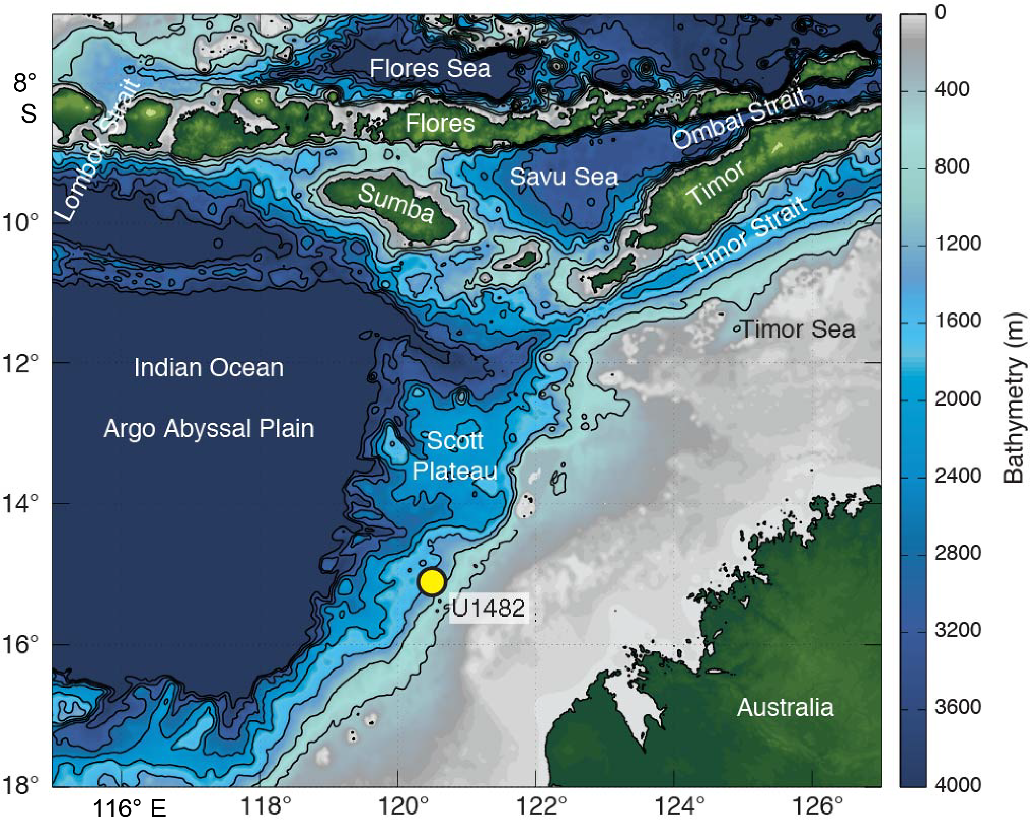
Figure F1. Location of Site U1482.
Methods
The Site U1482 cores were scanned with the second generation Avaatech X-ray fluorescence (XRF) core scanner at the Institute of Geosciences, University of Kiel. Elemental data were collected along the shipboard splice with approximately 1 m overlap at the splice tie points. Measurements were taken every 2 cm for Sections 363-U1482B-1H-1 (0 m CCSF) to 363-U1482D-6H-6, 142 cm (209.07 m CCSF), and every 1 cm for Sections 363-U1482D-6H-7 (209.08 m CCSF) to 363-U1482C-43H-7, 80 cm (451.25 m CCSF), over a 1.2 cm2 area with a downcore slit size of 10 mm and a crosscore slit size of 12 mm. Scanning was performed using the generator settings of 10 kV, 750 µA, 10 s acquisition time, and no filter. The archive core sections were gently scraped with a thin glass plate to remove the uppermost surface layer to provide a fresh, even sediment surface for scanning. The core sections were then covered with 4 µm thick Chemplex Prolene Thin-Film foil to prevent contamination. Data were acquired using the XR-100CR detector from Amptek and the Oxford Instrument 50W XTF5011 X-ray tube with rhodium (Rh) target material. The iterative least-square software package WIN_AXIL from Canberra Eurisys and a core-specific model were used to convert raw X-ray spectra into area counts. Results are reported as logarithms of elemental ratios, which provide the most easily interpretable signals of relative changes in chemical composition and minimize the risk of measurement artifacts (Weltje and Tjallingii, 2008). For checking and revising the splice, we used the logarithmic ratio of calcium (Ca) to the sum of the terrigenous elements (Al, K, Ti, Fe, and Si), referred to as Log(Ca/Terr.), which presents a distinct high-amplitude signal. Adjustments were made to the original shipboard splice when offsets between holes exceeded 10 cm at tie points. We did not revise offsets of less than 10 cm between holes because these fall within the range of uncertainty introduced during postcruise core handling (e.g., expansion of sections during transport).
Splice and composite depth scale revision
Based on the new high-resolution XRF elemental data, we adjusted the position of nine tie points in the original shipboard sediment splice (Table T1; Figure F2). The interval from 0 to 12.38 m CCSF shows clear evidence of soft-sediment deformation and does not appear to be stratigraphically continuous. No modifications were made to the first three tie points of the shipboard splice within this interval (Table T1). The revised cumulative offset for all cores is given in Table T2 and available from the IODP Laboratory Information Management System (LIMS) database. XRF elemental data used for the revision of the splice are shown in Table T3 and Figures F3–F11.
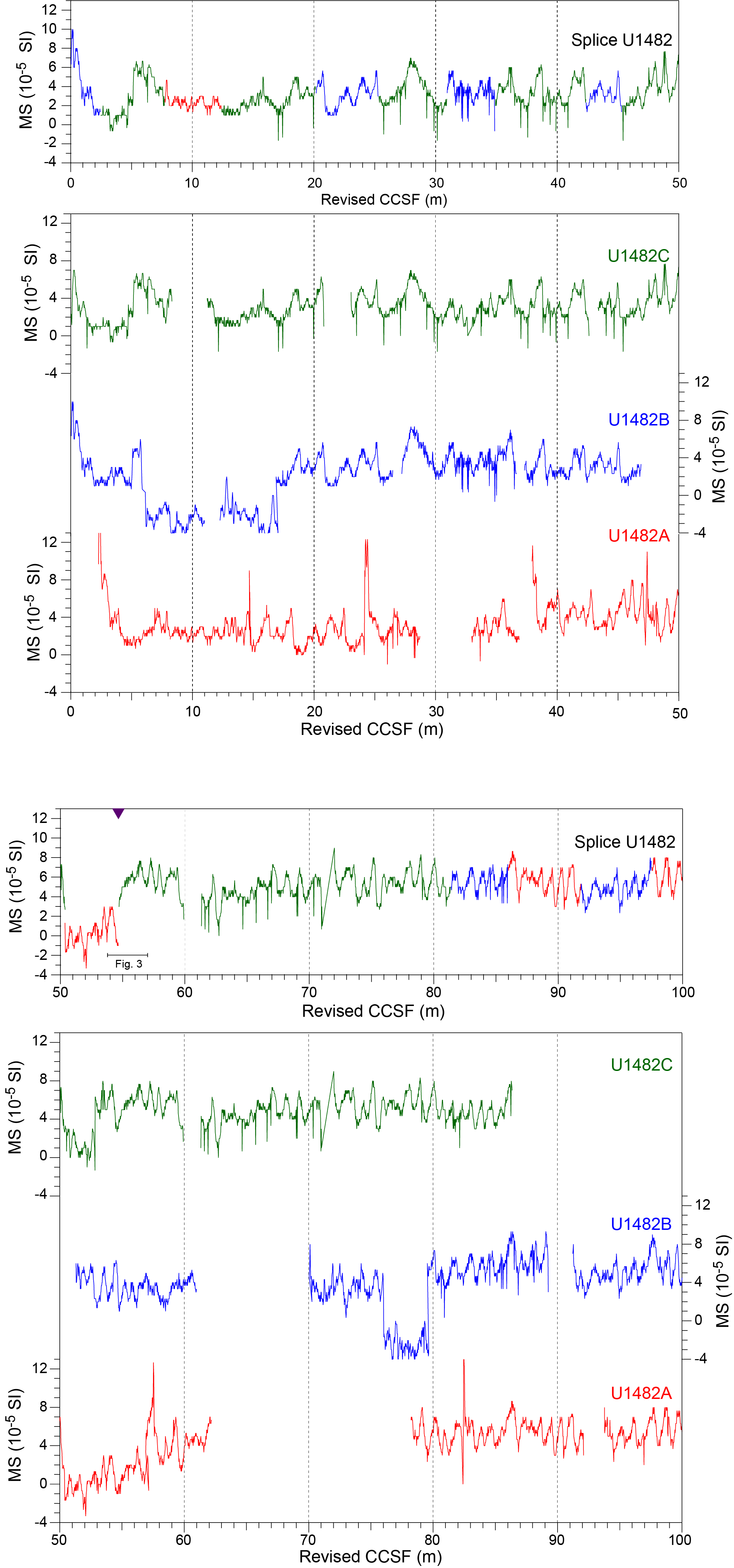
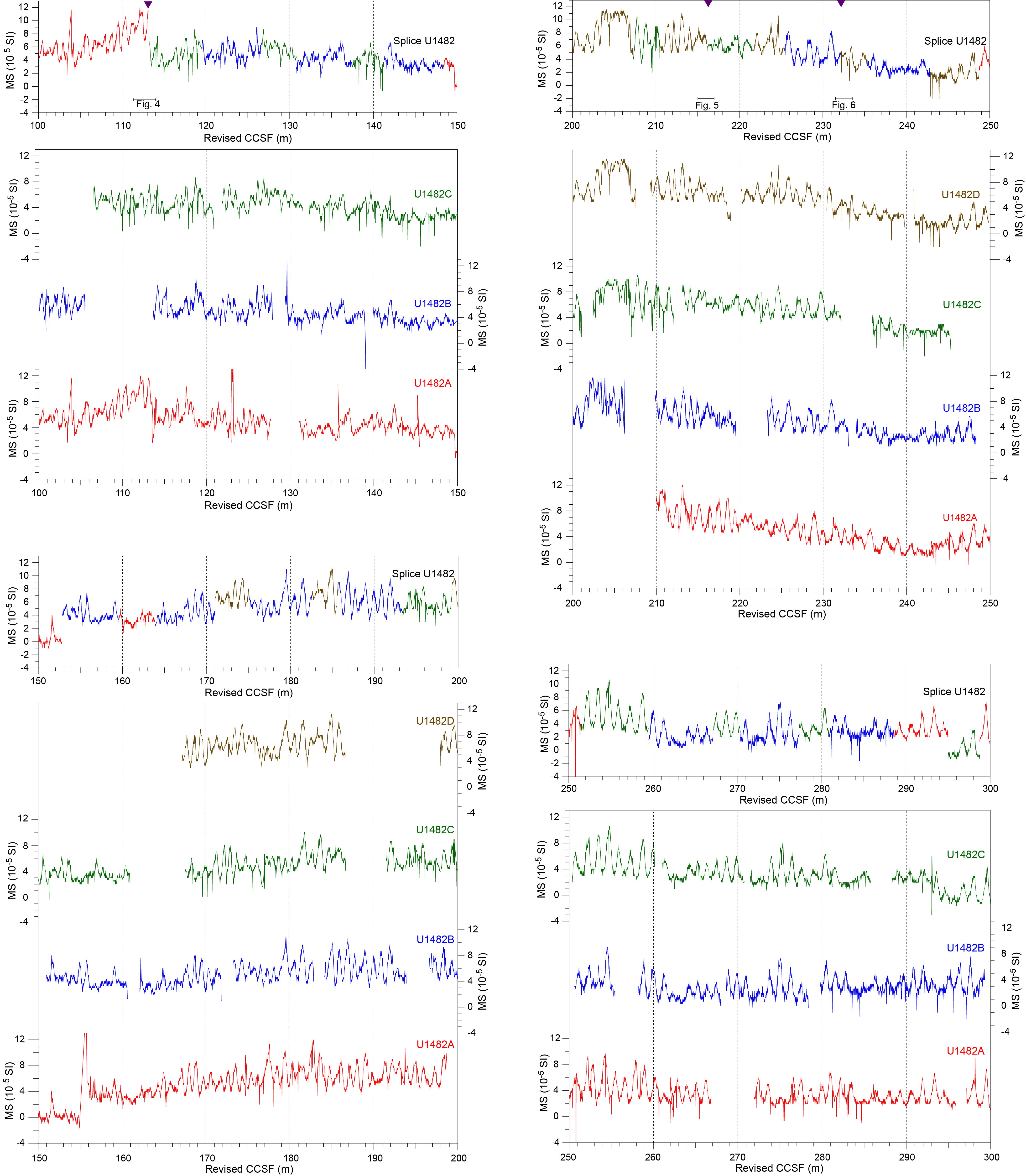
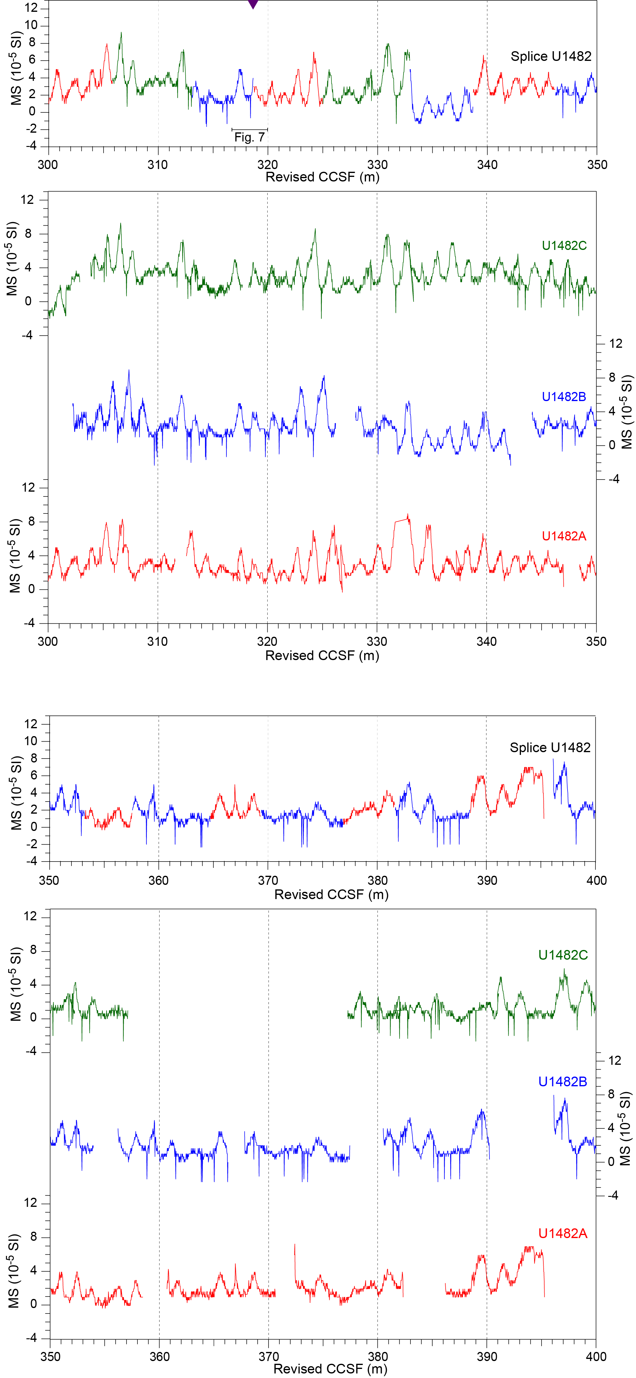
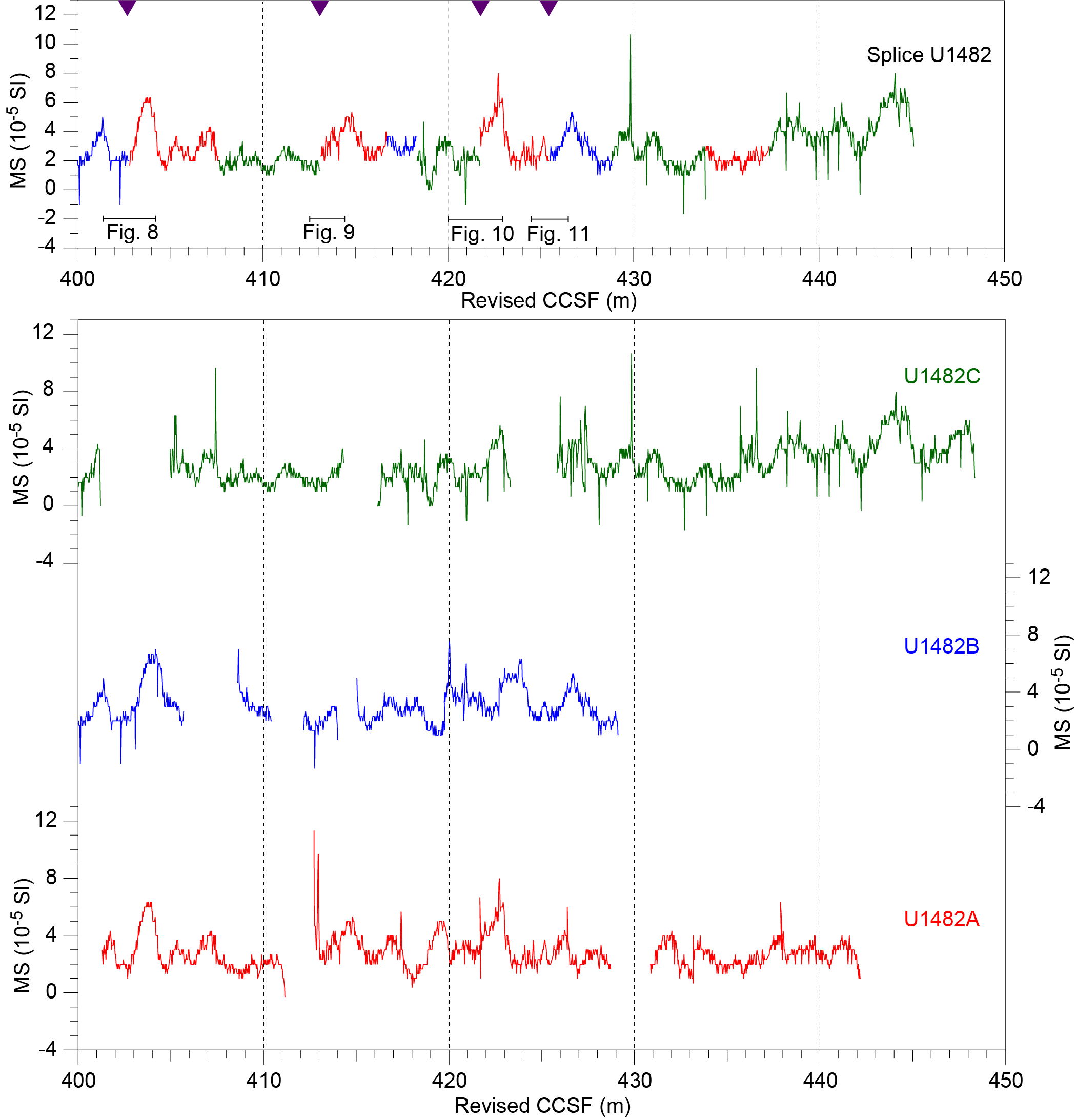
Figure F2. Magnetic susceptibility.
In the original splice, the XRF data revealed that a distinctive feature was duplicated in intervals between 54.13 and 56.17 m CCSF in Hole U1482A and between 56.70 and 58.84 m CCSF in Hole U1482C (Figure F3). Therefore, we adjusted the tie point at 57.14 m CCSF, which originally connected interval 363-U1482A-6H-7, 77 cm, to interval 363-U1482C-7H-3, 126 cm. For this, we deleted 2.47 m from Hole U1482A and 0.12 m from Hole U1482C and defined a new tie point connecting interval 363-U1482A-6H-5, 130 cm, to interval 363-U1482C-7H-3, 138 cm (Figure F3). This resulted in a total deletion of 2.59 m from the shipboard splice, giving a depth of 54.67 m revised CCSF for this new tie point.
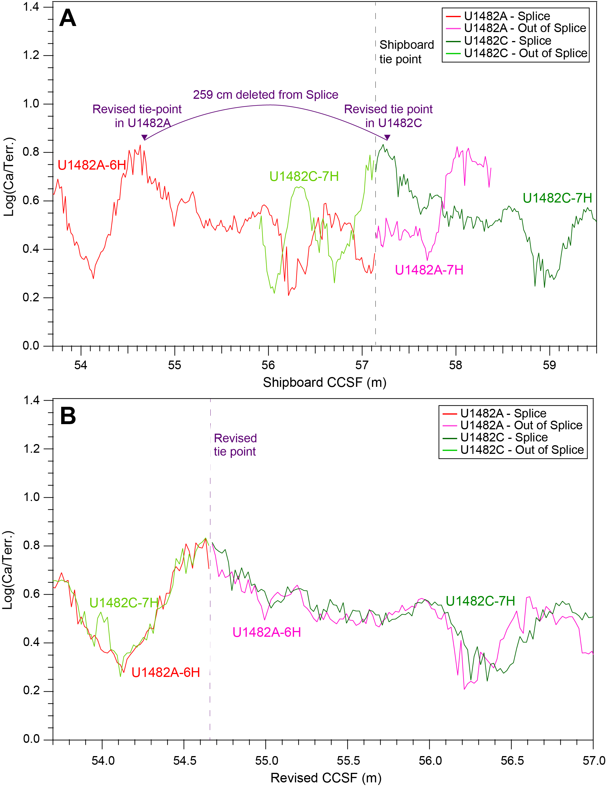
Figure F3. Revised tie point at 54.67 m revised CCSF.
We adjusted the tie point originally connecting interval 363-U1482A-10H-7, 9 cm, with interval 363-U1482C-11H-2, 39 cm, at 115.63 m CCSF (Figure F4). For this, we added 0.13 m to Hole U1482A and removed 0.21 m from Hole U1482C (Figure F4). This resulted in a total deletion of 0.08 m from the shipboard splice. The revised tie point now connects interval 363-U1482A-10H-7, 22 cm, to interval 363-U1482C-11H-2, 60 cm, at 113.17 m revised CCSF (Figure F4).
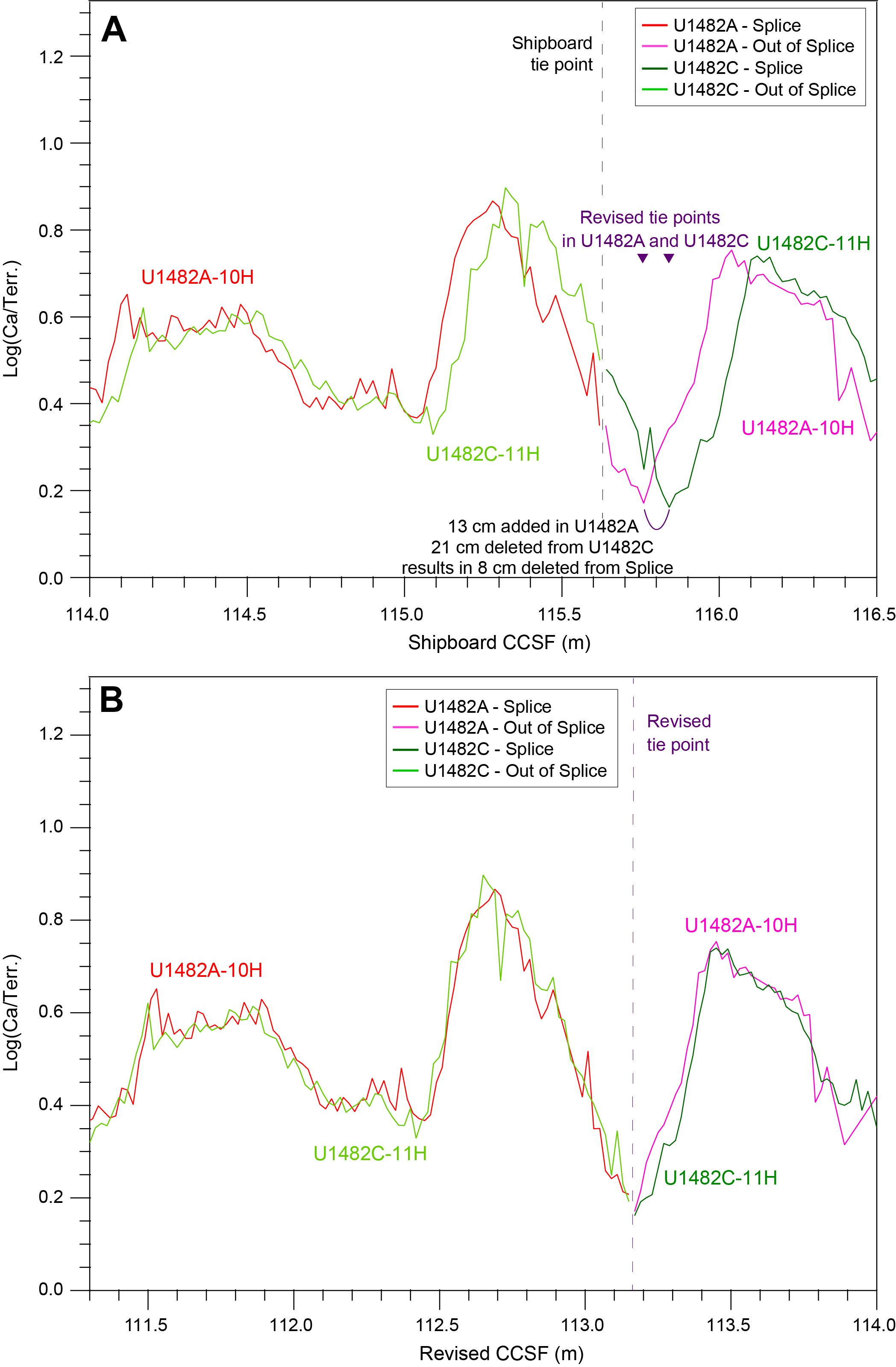
Figure F4. Revised tie point at 113.17 m revised CCSF.
We revised the tie point at 219.10 m CCSF originally connecting interval 363-U1482D-7H-6, 8 cm, to interval 363-U1482C-21H-3, 19 cm, by defining a new tie point at 216.29 m revised CCSF to connect interval 363-U1482D-7H-5, 136 cm, to interval 363-U1482C-21H-3, 29 cm, (Figure F5). For this revision, 0.13 m were deleted from Hole U1482D and 0.10 m were deleted from Hole U1482C, resulting in the removal of 0.23 m from the original shipboard splice (Figure F5).
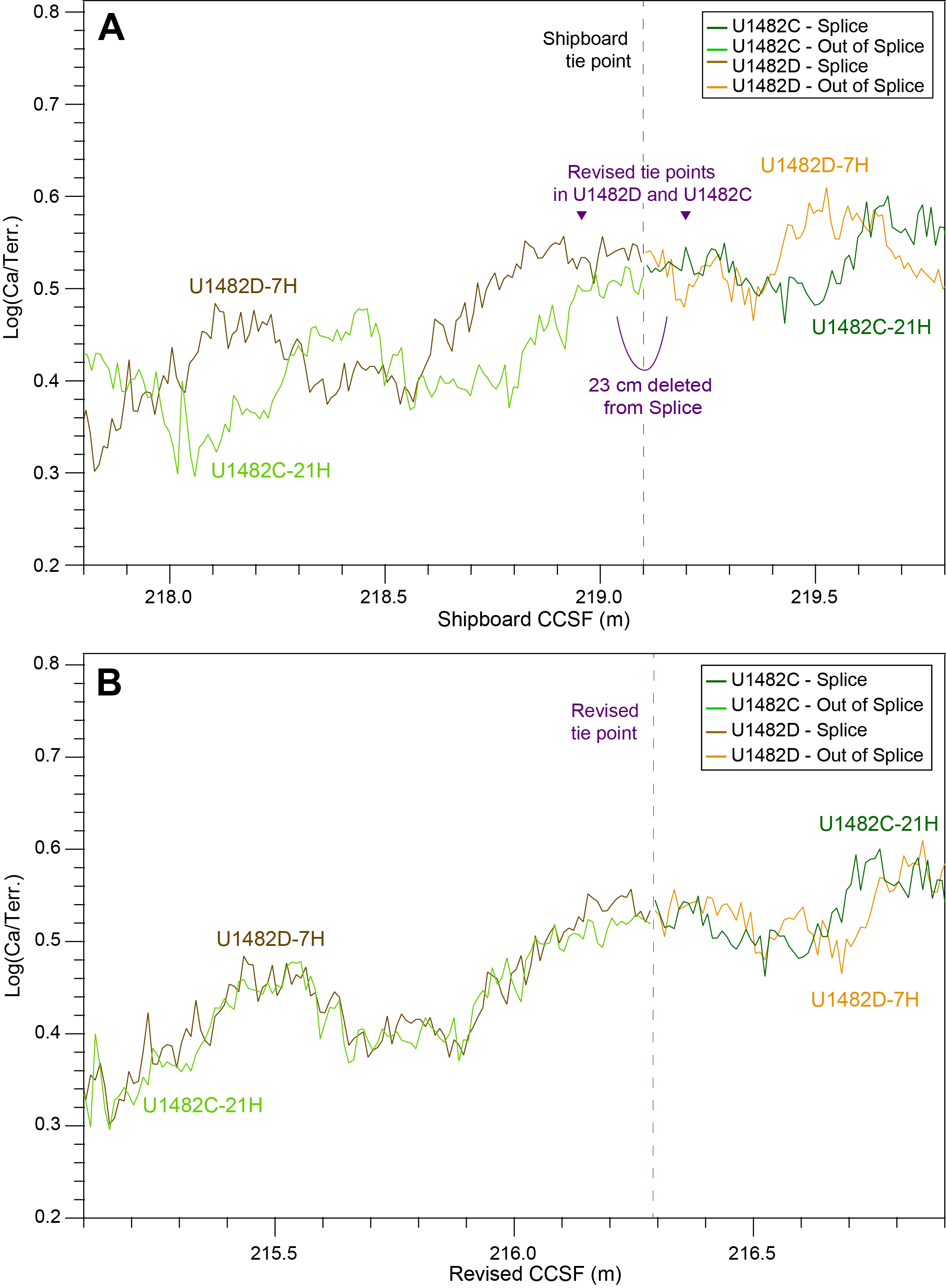
Figure F5. Revised tie point at 216.29 m revised CCSF.
To revise the shipboard tie point at 234.84 m CCSF, which originally tied interval 363-U1482B-23H-7, 1 cm, to interval 363-U1482D-9H-1, 119 cm, we selected the minimum within a distinctive drop in the Log(Ca/Terr.) data of Holes U1482B and U1482D (Figure F6). The new tie point connects interval 363-U1482B-23H-7, 28 cm, to interval 363-U1482D-9H-2, 40 cm, at 232.20 m revised CCSF (Figure F6). For this revision, 0.27 m were added in Hole U1482B and 0.63 m were deleted in Hole U1482D, resulting in a total removal of 0.36 m from the original splice (Figure F6).
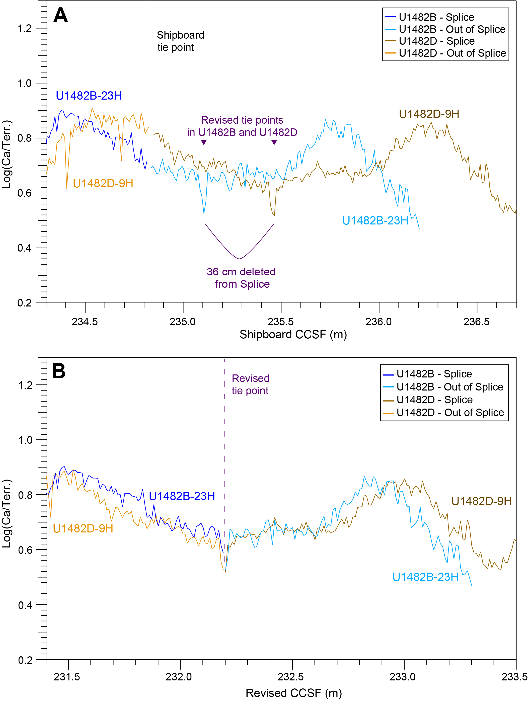
Figure F6. Revised tie point at 232.20 m revised CCSF.
In the original splice, the XRF data revealed that a distinctive feature was duplicated between 320.76 and 321.90 m CCSF in Hole U1482B and between 322.58 and 323.65 m CCSF in Hole U1482A (Figure F7). We adjusted the shipboard tie point at 323.16 m CCSF connecting interval 363-U1482B-32H-6, 119 cm, to interval 363-U1482A-30H-1, 103 cm, by deleting 1.26 m from Hole U1482B and 0.48 m from Hole U1482A (Figure F7). This resulted in a total deletion of 1.74 m from the original shipboard splice. The new tie point, which links interval 363-U1482B-32H-5, 135 cm, to interval 363-U1482A-30H-1, 151 cm, is at 318.64 m revised CCSF (Figure F7).
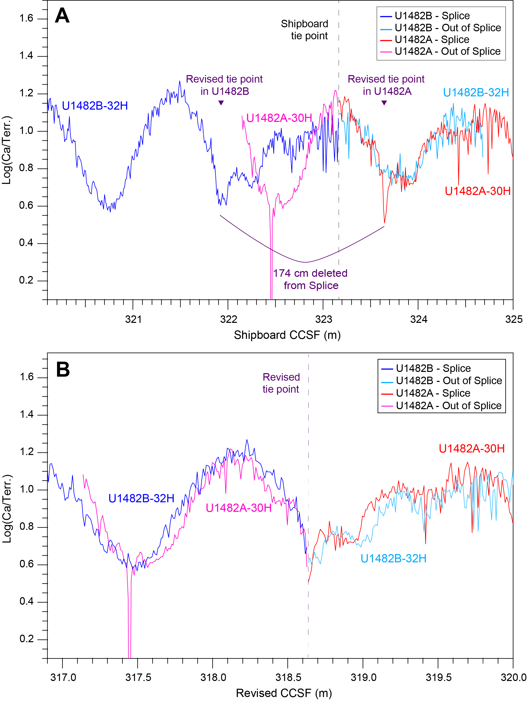
Figure F7. Revised tie point at 318.64 m revised CCSF.
We revised the tie point connecting interval 363-U1482B-39H-5, 119 cm, to interval 363-U1482A-37H-1, 138 cm, at 408.01 m CCSF by removing 0.18 m from Hole U1482B and 0.16 m from Hole U1482A, which resulted in a total deletion of 0.34 m from the shipboard splice (Figure F8). The revised tie point now connects interval 363-U1482B-39H-5, 100 cm, to interval 363-U1482A-37H-2, 12 cm, at 402.81 m revised CCSF (Figure F8).
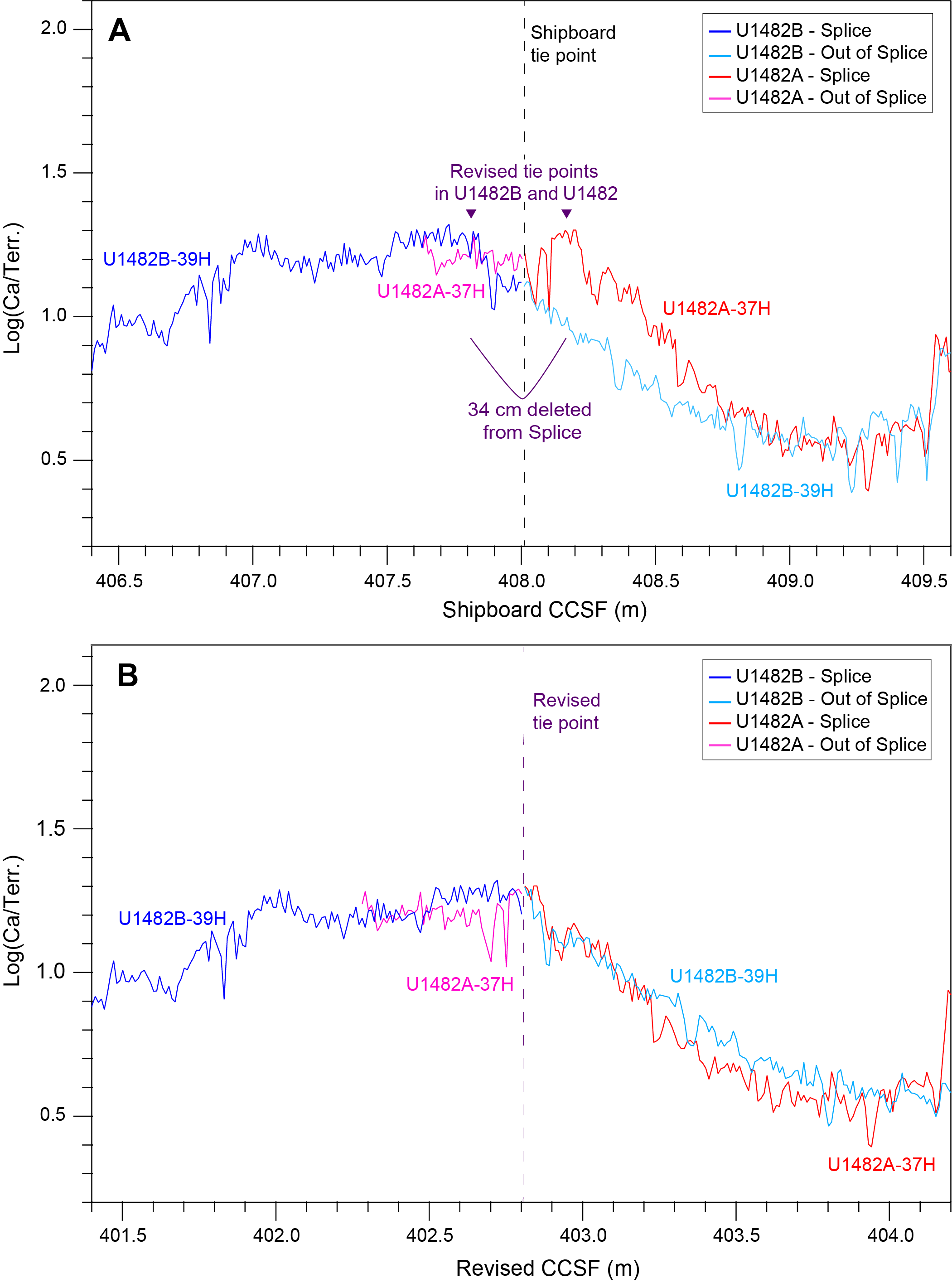
Figure F8. Revised tie point at 402.81 m revised CCSF.
We adjusted the shipboard tie point at 418.71 m CCSF and linked interval 363-U1482C-39X-6, 133 cm, to interval 363-U1482A-38F-1, 37 cm, by deleting 0.25 m from Hole U1482C and 0.05 m from Hole U1482A, which resulted in a total removal of 0.30 m from the shipboard splice (Figure F9). The revised tie point now connects interval 363-U1482C-39X-6, 108 cm, to interval 363-U1482A-38F-1, 42 cm, at 413.10 m revised CCSF (Figure F9).
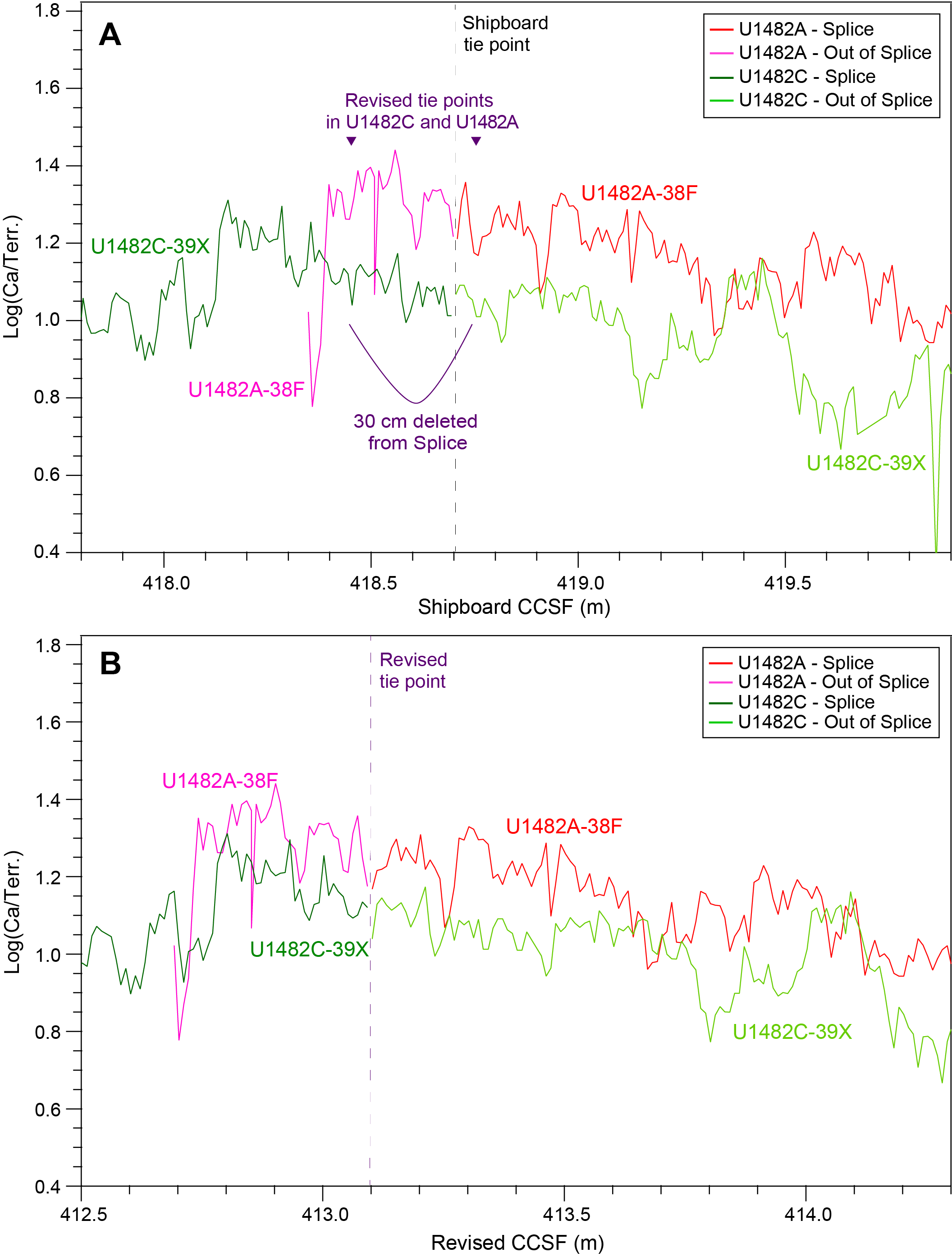
Figure F9. Revised tie point at 413.10 m revised CCSF.
We revised the tie point at 427.91 m CCSF, which tied interval 363-U1482C-40X-5, 15 cm, to interval 262-U1482A-40F-1, 5 cm, by deleting 0.55 m from Hole U1482C and 0.01 m from Hole U1482A. This resulted in a total removal of 0.56 m from the shipboard splice (Figure F10). The new tie point at 421.71 m revised CCSF connects interval 363-U1482C-40X-4, 110 cm, to interval 363-U1482A-40F-1, 7 cm (Figure F10).
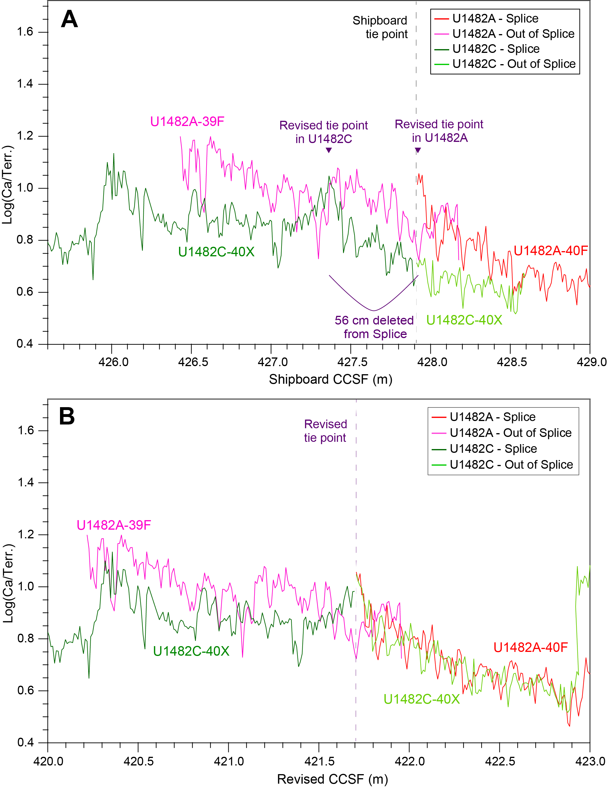
Figure F10. Revised tie point at 421.71 m revised CCSF.
The last adjustment was the tie point at 431.77 m CCSF, which connected interval 363-U1482A-40F-3, 107 cm, to interval 363-U1482B-45F-1, 130 cm (Figure F11). For this revision, we deleted 0.10 m from Hole U1482A and added 0.18 m to Hole U1482B, resulting in the addition of 0.08 m to the original shipboard splice (Figure F11). The revised tie point at 425.45 m revised CCSF ties interval 363-U1482A-40F-3, 97 cm, to interval 363-U1482B-45F-1, 112 cm (Figure F11).
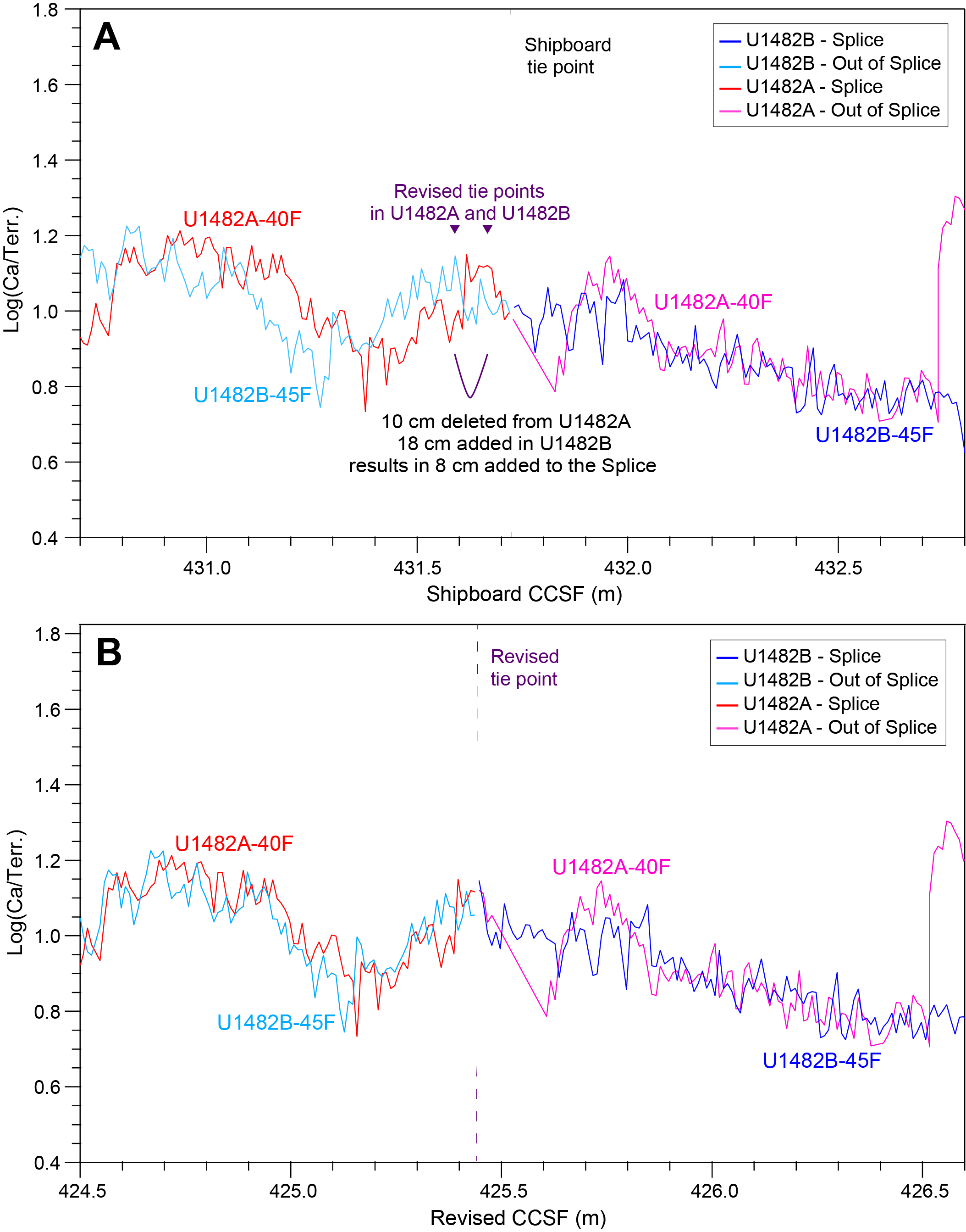
Figure F11. Revised tie point at 425.45 m revised CCSF.
The revision of these nine tie points removed a total of 6.14 m (Table T1) from the shipboard splice. The revised splice now extends to 445.11 m revised CCSF (Figure F2; Table T1).
Acknowledgments
This research used samples and data provided by the International Ocean Discovery Program and was funded by the Deutsche Forschungsgemeinschaft (Grant HO2311/5-1). We gratefully acknowledge Ursula Röhl and Alex Wülbers from the IODP Bremen Core Repository and Doris Maicher and Maik Lange from the Helmholtz Centre for Ocean Research Kiel (GEOMAR) for logistical assistance with handling and storing cores. We thank Steve Clemens and Denise Kulhanek for constructive reviews that helped us to clarify and improve this report.
References
Rosenthal, Y., Holbourn, A.E., Kulhanek, D.K., Aiello, I.W., Babila, T.L., Bayon, G., Beaufort, L., Bova, S.C., Chun, J.-H., Dang, H., Drury, A.J., Dunkley Jones, T., Eichler, P.P.B., Fernando, A.G.S., Gibson, K.A., Hatfield, R.G., Johnson, D.L., Kumagai, Y., Li, T., Linsley, B.K., Meinicke, N., Mountain, G.S., Opdyke, B.N., Pearson, P.N., Poole, C.R., Ravelo, A.C., Sagawa, T., Schmitt, A., Wurtzel, J.B., Xu, J., Yamamoto, M., and Zhang, Y.G., 2018a. Expedition 363 methods. In Rosenthal, Y., Holbourn, A.E., Kulhanek, D.K., and the Expedition 363 Scientists, Western Pacific Warm Pool. Proceedings of the International Ocean Discovery Program, 363: College Station, TX (International Ocean Discovery Program). https://doi.org/10.14379/iodp.proc.363.102.2018
Rosenthal, Y., Holbourn, A.E., Kulhanek, D.K., Aiello, I.W., Babila, T.L., Bayon, G., Beaufort, L., Bova, S.C., Chun, J.-H., Dang, H., Drury, A.J., Dunkley Jones, T., Eichler, P.P.B., Fernando, A.G.S., Gibson, K.A., Hatfield, R.G., Johnson, D.L., Kumagai, Y., Li, T., Linsley, B.K., Meinicke, N., Mountain, G.S., Opdyke, B.N., Pearson, P.N., Poole, C.R., Ravelo, A.C., Sagawa, T., Schmitt, A., Wurtzel, J.B., Xu, J., Yamamoto, M., and Zhang, Y.G., 2018b. Site U1482. In Rosenthal, Y., Holbourn, A.E., Kulhanek, D.K., and the Expedition 363 Scientists, Western Pacific Warm Pool. Proceedings of the International Ocean Discovery Program, 363: College Station, TX (International Ocean Discovery Program). https://doi.org/10.14379/iodp.proc.363.103.2018
Weltje, G.J., and Tjallingii, R., 2008. Calibration of XRF core scanners for quantitative geochemical logging of sediment cores: theory and application. Earth and Planetary Science Letters, 274(3–4):423–438. https://doi.org/10.1016/j.epsl.2008.07.054
1 Lübbers, J., Holbourn, A.E., Kuhnt, W., and Beil, S., 2020. Data report: revision of IODP Expedition 363 Site U1482 shipboard sediment splice based on X-ray fluorescence scanning elemental data. In Rosenthal, Y., Holbourn, A.E., Kulhanek, D.K., and the Expedition 363 Scientists, Western Pacific Warm Pool. Proceedings of the International Ocean Discovery Program, 363: College Station, TX (International Ocean Discovery Program). https://doi.org/10.14379/iodp.proc.363.202.2020
2 Institute of Geosciences, University of Kiel, Germany. Correspondence author: julia.luebbers@ifg.uni-kiel.de
This work is distributed under the Creative Commons Attribution 4.0 International (CC BY 4.0) license. 