Webster, J.M., Ravelo, A.C., Grant, H.L.J., and the Expedition 389 Scientists
Proceedings of the International Ocean Discovery Program Volume 389
publications.iodp.org
https://doi.org/10.14379/iodp.proc.389.112.2025
Site M01051
![]() J.M. Webster,
J.M. Webster,
![]() A.C. Ravelo,
A.C. Ravelo,
![]() H.L.J. Grant,
H.L.J. Grant,
![]() M. Rydzy,
M. Rydzy,
![]() M. Stewart,
M. Stewart,
![]() N. Allison,
N. Allison,
![]() R. Asami,
R. Asami,
![]() B. Boston,
B. Boston,
![]() J.C. Braga,
J.C. Braga,
![]() L. Brenner,
L. Brenner,
![]() X. Chen,
X. Chen,
![]() P. Chutcharavan,
P. Chutcharavan,
![]() A. Dutton,
A. Dutton,
![]() T. Felis,
T. Felis,
![]() N. Fukuyo,
N. Fukuyo,
![]() E. Gischler,
E. Gischler,
![]() S. Greve,
S. Greve,
![]() A. Hagen,
A. Hagen,
![]() Y. Hamon,
Y. Hamon,
![]() E. Hathorne,
E. Hathorne,
![]() M. Humblet,
M. Humblet,
![]() S. Jorry,
S. Jorry,
![]() P. Khanna,
P. Khanna,
![]() E. Le Ber,
E. Le Ber,
![]() H. McGregor,
H. McGregor,
![]() R. Mortlock,
R. Mortlock,
![]() T. Nohl,
T. Nohl,
![]() D. Potts,
D. Potts,
![]() A. Prohaska,
A. Prohaska,
![]() N. Prouty,
W. Renema,
N. Prouty,
W. Renema,
![]() K.H. Rubin,
K.H. Rubin,
![]() H. Westphal, and
H. Westphal, and
![]() Y. Yokoyama2
Y. Yokoyama2
1 Webster, J.M., Ravelo, A.C., Grant, H.L.J., Rydzy, M., Stewart, M., Allison, N., Asami, R., Boston, B., Braga, J.C., Brenner, L., Chen, X., Chutcharavan, P., Dutton, A., Felis, T., Fukuyo, N., Gischler, E., Greve, S., Hagen, A., Hamon, Y., Hathorne, E., Humblet, M., Jorry, S., Khanna, P., Le Ber, E., McGregor, H., Mortlock, R., Nohl, T., Potts, D., Prohaska, A., Prouty, N., Renema, W., Rubin, K.H., Westphal, H., and Yokoyama, Y., 2025. Site M0105. In Webster, J.M., Ravelo, A.C., Grant, H.L.J., and the Expedition 389 Scientists, Hawaiian Drowned Reefs. Proceedings of the International Ocean Discovery Program, 389: College Station, TX (International Ocean Discovery Program). https://doi.org/10.14379/iodp.proc.389.112.2025
2 Expedition 389 Scientists’ affiliations.
1. Operations
The multipurpose vessel MMA Valour was used as the drilling platform throughout Expedition 389. At all Expedition 389 sites, dynamic positioning was used to provide accurate positions throughout operations and water depth was established using a Sound Velocity Profiler (SVP) placed on the top of the PROD5 drilling system. For more detail on acquisition methods, see Introduction in the Expedition 389 methods chapter (Webster et al., 2025a).
Summary operational information for Site M0105 is provided in Table T1. All times stated are in Hawaiian Standard Time (HST).
1.1. Hole M0105A
The MMA Valour arrived on location at 0555 h on 16 October 2023. PROD5 was deployed at 0950 h at a water depth of 339.5 m. Rotary coring and casing in Hole M0105A began at 0959 h and continued to 26.08 meters below seafloor (mbsf) at 0649 h on 17 October. The borehole was terminated to allow recovery of core barrels and casing and transit to port to address a medical issue with a drilling contractor. PROD5 was recovered to deck by 0805 h, when on-deck operations commenced and core barrels were extracted for curation. Transit to the port of Hilo began at 0805 h on 17 October, and the vessel came alongside at 1036 h to allow the contractor to disembark. The MMA Valour departed port and the working area at 1125 h on 17 October in a southerly direction toward Site M0106 due to a forecast of heavy seas in the Hilo area.
A total of 14 cores were recovered from Hole M0105A from a total of 26.08 m of rotary coring. The recovered length of core was 7.63 m (29.26%).
2. Lithostratigraphy
Site M0105 was drilled at 339.5 meters below sea level (mbsl) to 26.14 mbsf in the Hilo region with very low recovery of nonvolcanic lithologies. Hole M0105A is divided into four main intervals:
- Interval 1 (0.00–0.32 mbsf) is composed of rhodoliths in a dark gray unconsolidated biodetrital and volcaniclastic sandy matrix. Because of poor recovery, the base of this interval is unknown.
- Interval 2 (7.43–7.69 mbsf) is dominated by algal boundstone. Because of poor recovery, the vertical extent and the boundaries of this interval are unknown.
- Interval 3 (12.95–15.46 mbsf) is dominated by a fragmented coralgal boundstone (predominantly columnar and robust branching Porites) embedded in unconsolidated biodetrital sediments.
- Interval 4 (18.12–26.14 mbsf) represents basaltic lava and associated clinker produced on the top and leading edge of ‘a‘a lava flows, much of which is fresh and unaltered, although zones of fracturing and alteration occur.
2.1. Hole M0105A
From 0.00 to 0.31 mbsf in Hole M0105A (Figure F1), a short interval of dominantly loose rhodoliths (less than 1 cm in diameter) in a dark gray matrix of unconsolidated biodetrital components (bivalves, gastropods, and foraminifers) and volcaniclastic medium sand-sized sediment was recovered (Figure F2A).
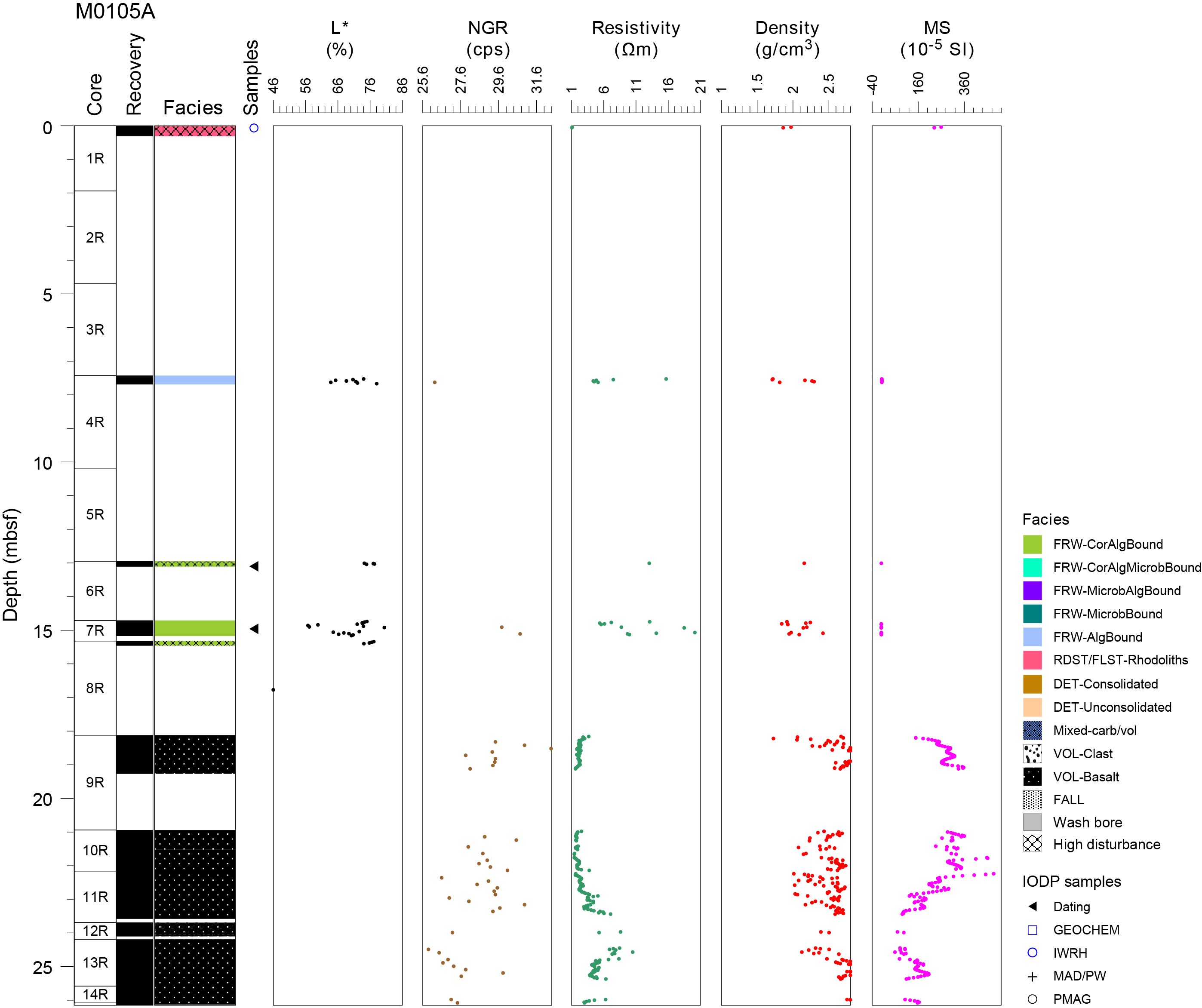
Figure F1. Lithostratigraphy and MSCL data.
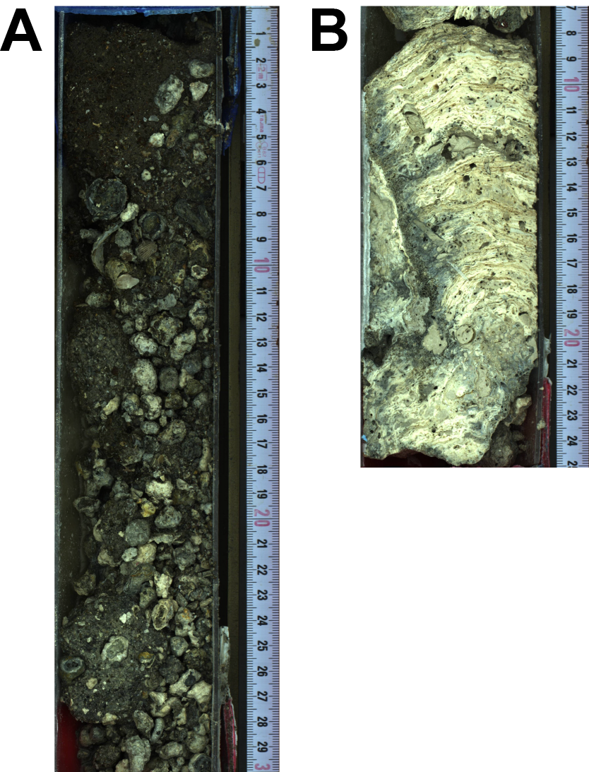
Figure F2. Lithologies.
After a gap in core recovery between 0.31 and 7.43 mbsf, 26 cm of disturbed algal boundstone was recovered. It consists of thick, heavily bored crustose coralline algae (CCA) crusts with intergrown laminar corals, vermetids, and Homotrema (Figure F2B). Some dark medium sand-sized volcaniclastic grains are trapped in the CCA.
A second gap in core recovery extends from 7.69 to 12.95 mbsf. From this depth to 15.46 mbsf, coring disturbance from drilling is high and core recovery is low. The recovered material consists of disturbed and undisturbed coralgal boundstones with columnar and robust branching Porites, a few Cyphastrea, and thin (less than 2 mm) bored CCA crusts (Figure F3). These fragments are embedded in an unconsolidated biodetrital matrix consisting of fragmented bivalves, gastropods, CCA, corals, and echinoid spines.
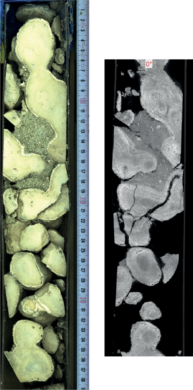
Figure F3. Fragmented columnar and robust branching Porites.
After a third gap in core recovery from 15.46 to 18.12 mbsf, the lithology changes to volcanic material. The contact between carbonate and lava was not recovered. From 18.12 mbsf to the bottom of the hole at 26.14 mbsf, the recovered material is primarily black, porphyritic (abundant olivine and pyroxene crystals), vesicular lava with a phaneritic groundmass texture (Figure F4A). Vesicles are generally abundant (10%–20%) and variable in size and character; in some areas they are millimeters in size (1–2 mm) and spherical (e.g., 25.36–25.98 mbsf), and in others they are larger (3–7 mm) and in many cases coalesced, for example at 21.00 mbsf. Locally, vesicles are filled with acicular aragonite. Lava characteristics vary locally. From 18.12 to 20.84 mbsf (Sections 389-M0105A-9R-1 and 10R-1), the lava is a coherent, unfractured, slightly altered lava rock with flow texture. From 20.84 to 23.58 mbsf (Section 11R-1), lava is still predominantly a coherent lava flow rock but is also locally fractured, with an orange-red staining along cracks. Some cracks and fractures are infilled with a reddish mud (Figure F4B). From 25.36 to 25.98 mbsf, the lava is variably altered, with a dark reddish color. It is fragmented with subrounded to subangular centimeter-sized fragments lacking a fine-grained component, possibly as lava clinker from an ‘a‘a lava flow (Figure F4C).
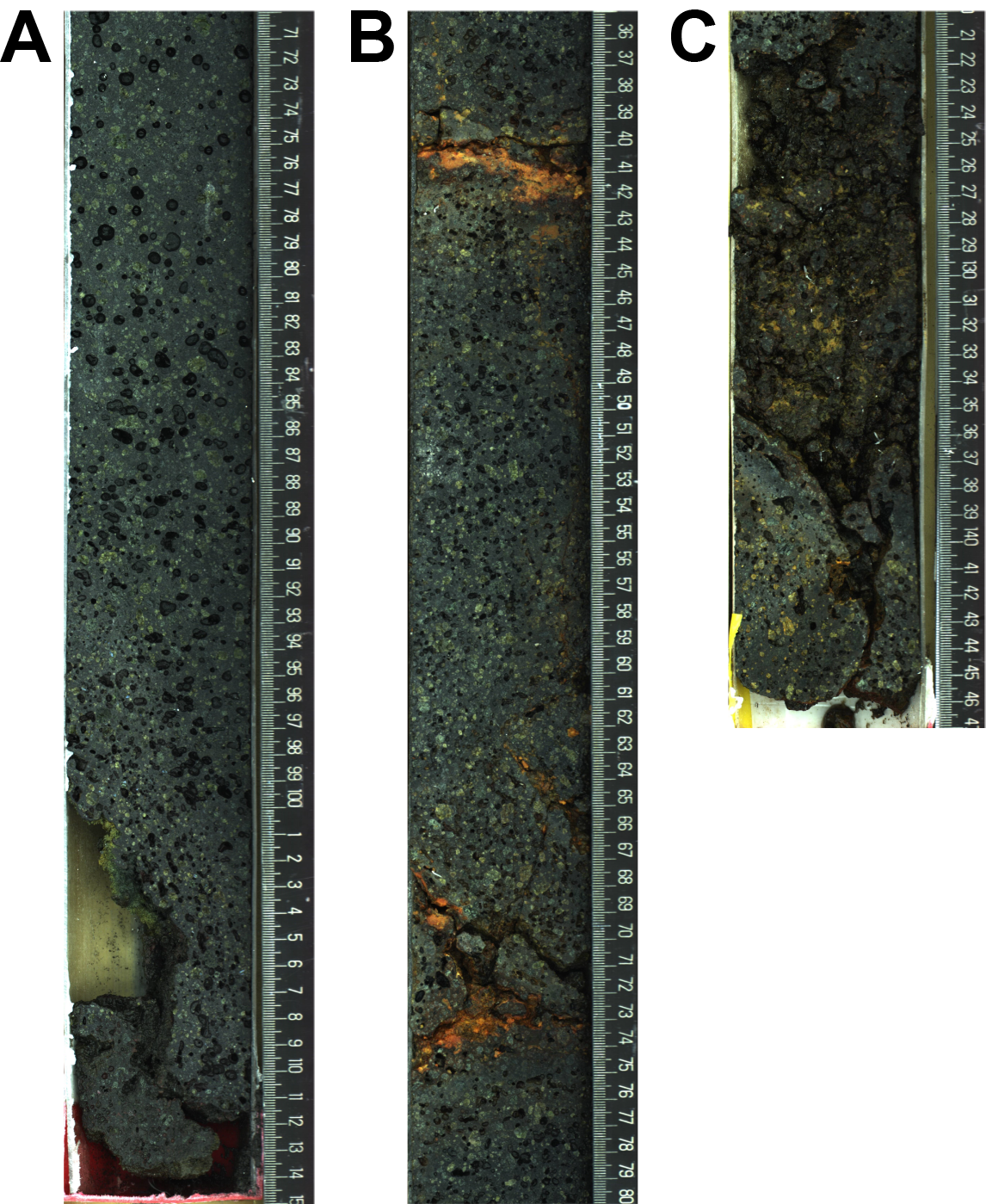
Figure F4. More lithologies.
3. Physical properties
Physical properties data for Site M0105 are shown in Table T2 in the Site M0096 chapter (Webster et al., 2025b).
3.1. Hole M0105A
A total of 7.49 m of core from Hole M0105A was scanned with the multisensor core logger (MSCL), and because the core exhibited moderate drilling-induced disturbance, 63% of the acquired data passed QA/QC (see Table T10 in the Expedition 389 methods chapter [Webster et al., 2025a]). A total of six discrete samples were taken for P-wave velocity and moisture and density (MAD) measurements. Digital linescans, color reflectance, and hyperspectral imaging were acquired on all cores.
3.1.1. Density and porosity
Data for density and porosity measurements are presented in Figures F1 and F5. MSCL density measurements range 1.71–3.03 g/cm3. The nature of the core quality (low recovery and drilling disturbance) means that the data quality is not optimal (see Physical properties in the Expedition 389 methods chapter [Webster et al., 2025a]). A total of six discrete samples were analyzed for MAD, giving a bulk density range of 2.12–2.84 g/cm3. Porosity values for the same samples range 14.2%–40.4%, and grain density values range 2.770–3.192 g/cm3.
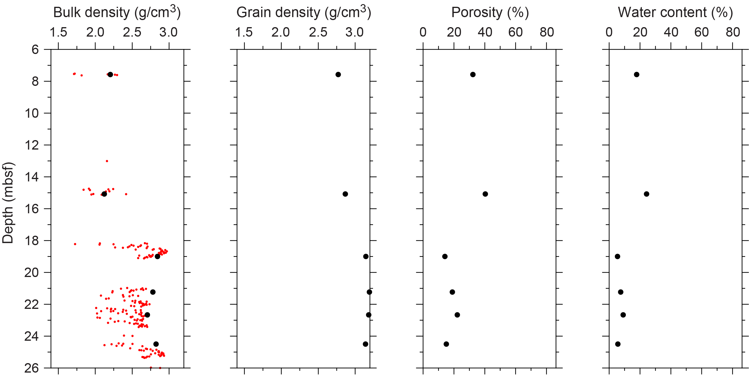
Figure F5. Physical properties.
3.1.2. P-wave velocity
P-wave velocity MSCL measurement yielded no data. A total of six samples were measured using the discrete P-wave logger. Dry measurement values range 3257–4626 m/s (Figure F6). P-wave velocity recorded for the samples after resaturation range 3898–5159 m/s. Because of the small number of P-wave data points, there are no apparent downhole trends.
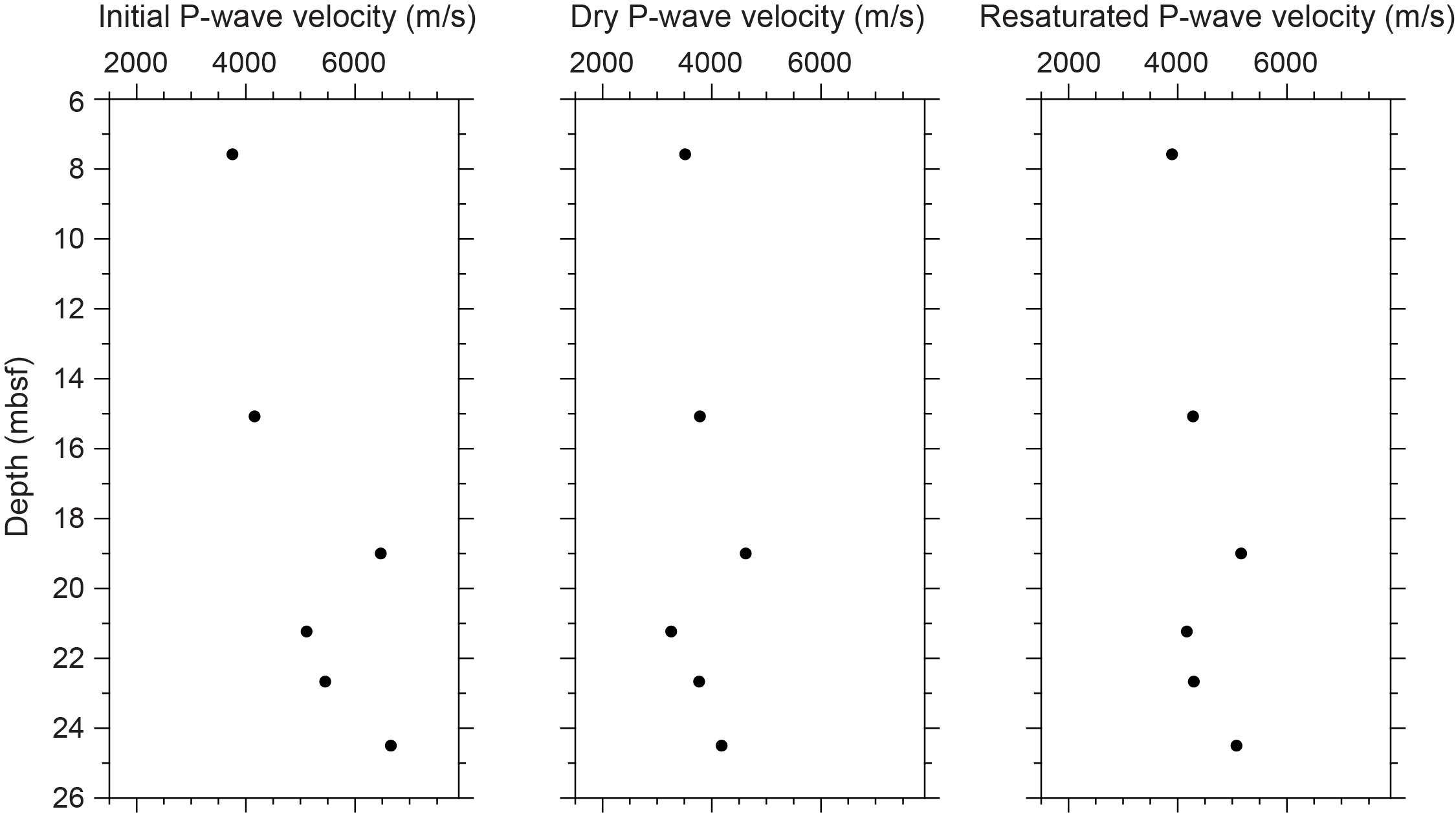
Figure F6. P-wave velocities.
3.1.3. Thermal conductivity
Thermal conductivity was measured on two cores (see Table T11 in the Expedition 389 methods chapter [Webster et al., 2025a]) and gave values of 1.957 and 2.187 (W/m·K).
3.1.4. Magnetic susceptibility
MSCL magnetic susceptibility data range −0.41 × 10⁻⁵ to 487.32 × 10⁻⁵ SI (Figure F1). Most of the magnetic susceptibility values fall between 100 × 10−5 and 487 × 10−5 SI and are associated with lava (18–26 mbsf). At about 23 mbsf, magnetic susceptibility values decrease sharply from 487 × 10−5 to 70 × 10−5 SI.
3.1.5. Electrical resistivity
MSCL noncontact resistivity measurements yielded data ranging 1.05–20.12 Ωm, with most values ranging 2–10 Ωm (Figure F1). There are no apparent downhole trends.
3.1.6. Natural gamma radiation
MSCL natural gamma radiation (NGR) measurements range 26–32 counts/s (Figure F1), showing no apparent downhole changes.
3.1.7. Digital linescans, color reflectance, and hyperspectral imaging
All cores were digitally scanned, measured for color reflectance (where appropriate), and imaged with the hyperspectral scanner (see HYPERSPECTRAL in Supplementary material). Color reflectance L* values vary between 0.09% and 80.42% (Figure F1), a* varies between −1.94 and 6.91, b* varies between −0.83 and 19.69, and a*/b* varies between −1.78 and 7.94. Lower values in color reflectance below 18 mbsf reflect the change in lithology to lava (see Lithostratigraphy).
4. Geochemistry
4.1. Interstitial water
Two interstitial water samples were collected from Hole M0105A. These samples are generally within the range of other Expedition 389 interstitial water samples (see Tables T15 and T17 in the Expedition 389 methods chapter [Webster et al., 2025a]). However, there are slight differences between the samples in their Al and Mn concentrations. Sample 1R-1, 1 cm (0.01 mbsf), has an Al concentration below detection limits (similar to most Expedition 389 interstitial water samples) and a Mn concentration of 0.13 mg/L, whereas Sample 1R-1, 3 cm (0.03 mbsf), has an Al concentration of 0.213 mg/L and a Mn concentration below detection limits.
4.2. Surface seawater
One surface seawater sample was collected at Site M0105 using a Niskin bottle deployed from the side of the vessel (see Figure F22 in the Expedition 389 methods chapter [Webster et al., 2025a]). The salinity, pH, alkalinity, and concentrations of ammonium were analyzed off shore, and major cations and anions were measured during the Onshore Science Party. The salinity, pH, alkalinity, ammonium, and major element chemistry measured for this sample are consistent with the other surface seawater samples taken during Expedition 389 and align with the expected values for conservative elements in seawater (see Tables T15 and T17 in the Expedition 389 methods chapter [Webster et al., 2025a]).
4.3. Bulk sediment
Two bulk sediment samples were taken from Hole M0105A (Figure F1) and analyzed for mineralogy, elemental composition, and carbon content. One sample was taken from algal boundstone at 7.46 mbsf (see Figure F10 in the Expedition 389 methods chapter [Webster et al., 2025a]) and the other sample from a lava unit at 22.96 mbsf.
4.4. Mineralogy
The basalt sample from Hole M0105A (11R-1, 80–84 cm; 22.96 mbsf) is composed of entirely plagioclase (46%) and pyroxene (54%), whereas the algal boundstone sample (4R-1, 3–9 cm; 7.46 mbsf) contains high-Mg calcite (23%), aragonite (66%), amphiboles (5%), Mn-carbonates (3%), and pyroxene (3%) (Table T2).
4.5. Elemental abundances
The elemental compositions of the two samples from Hole M0105A vary due to their differing lithologies (Table T3). The basalt sample (11R-1, 80–84 cm; 22.96 mbsf) contains 55,448 mg/kg Ca, 63,678 mg/kg Mg, 1,101 mg/kg Mn, 301 mg/kg Sr, 54,557 mg/kg Al, 76,838 mg/kg Fe, and 173621 mg/kg Si. The algal boundstone sample (4R-1, 3–9 cm; 7.46 mbsf) contains 354,429 mg/kg Ca, 22,748 mg/kg Mg, 5,566 mg/kg Sr, and 1,428 mg/kg Fe and Al, Mn, and Si are below detection limits. Other elements (Ba, Br, K, P, S, Ti, Zr, Cr, Cu, Ni, Rb, V, and Zn) are minor constituents and/or below detection in the samples.
4.6. Carbon content
The basalt sample from Hole M0105A (11R-1, 80–84 cm; 22.96 mbsf) contains 0.70% total carbon (TC), 0.11% total organic carbon (TOC), and 0.59% total inorganic carbon (TIC). The algal boundstone sample (4R-1, 3–9 cm; 7.46 mbsf) contains 11.20% TC, 0.28% TOC, and 10.92% TIC (Table T4), calculating to approximately 90% CaCO3, consistent with the sample’s lithology, mineralogy, and element abundances.
5. Paleomagnetism
Seven plug samples were obtained from Hole M0105A. Low-field and mass-specific magnetic susceptibility (χ) measurements were carried out on all samples. Natural remanent magnetization (NRM) was measured for all samples, as well as remanence following stepwise alternating field (AF) demagnetization up to a peak AF of 20 mT for carbonate samples and 100 mT for lava samples. For further details, see Paleomagnetism in the Expedition 389 methods chapter (Webster et al., 2025a).
5.1. Hole M0105A
Two carbonate and five lava samples were obtained from Hole M0105A. The carbonate samples from 7.60 mbsf (Sample 4R-1, 15–18 cm) and 15.14 mbsf (Sample 7R-1, 42–44 cm) have low χ values of 4.04 × 10⁻⁸ and −0.44 × 10⁻⁸ m3/kg, respectively. The lava samples have relatively high positive χ values throughout, ranging 4.07 × 10⁻⁶ to 0.16 × 10⁻⁶ m3/kg with an arithmetic mean of 9.63 × 10⁻⁶ m3/kg. The initial NRM intensities of the carbonate samples are 1.07 × 10⁻³ and 0.30 × 10⁻³ A/m, respectively. The initial NRM intensity of basaltic lava ranges 4.02 to 10.6 A/m with an arithmetic mean of 5.48 A/m. Values of χ and initial NRM co-vary, suggesting that concentration and properties of magnetic particles are the main drivers behind these variations (Figure F7).
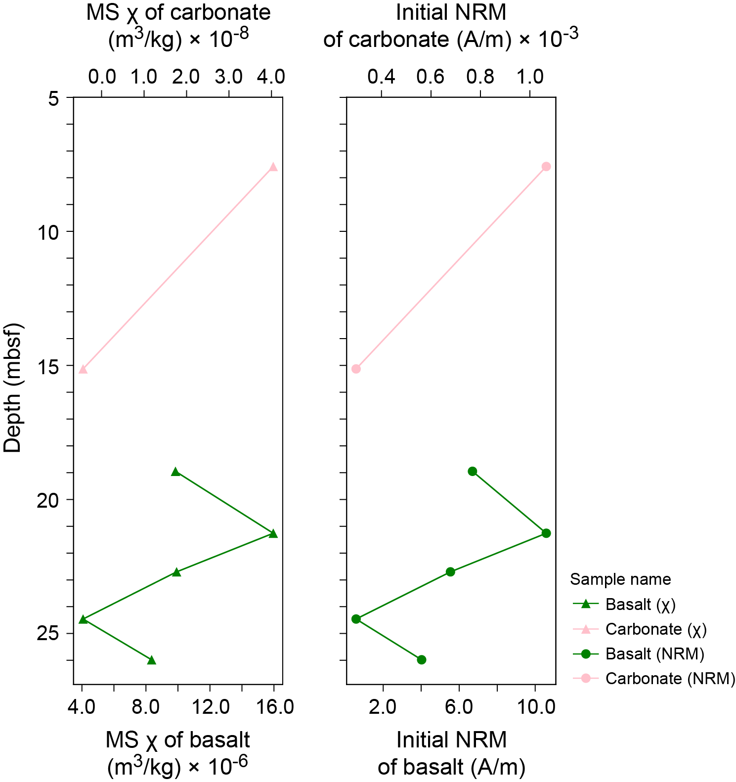
Figure F7. MS and NRM.
6. Geochronology
There are two U-Th dates from Site M0105, both from Hole M0105A, and they are dated to ~132 ky BP (see Tables T21 and T22 in the Expedition 389 methods chapter [Webster et al., 2025a]). Neither date is rejected based on the U-Th geochemistry. These data are consistent with the previously inferred timing of formation of the H2 terrace (Webster et al., 2009; Puga-Bernabéu et al., 2016).
References
Puga-Bernabéu, Á., Webster, J.M., Braga, J.C., Clague, D.A., Dutton, A., Eggins, S., Fallon, S., Jacobsen, G., Paduan, J.B., and Potts, D.C., 2016. Morphology and evolution of drowned carbonate terraces during the last two interglacial cycles, off Hilo, NE Hawaii. Marine Geology, 371:57–81. https://doi.org/10.1016/j.margeo.2015.10.016
Webster, J.M., Braga, J.C., Clague, D.A., Gallup, C., Hein, J.R., Potts, D.C., Renema, W., Riding, R., Riker-Coleman, K., Silver, E., and Wallace, L.M., 2009. Coral reef evolution on rapidly subsiding margins. Global and Planetary Change, 66(1–2):129–148. https://doi.org/10.1016/j.gloplacha.2008.07.010
Webster, J.M., Ravelo, A.C., Grant, H.L.J., Rydzy, M., Stewart, M., Allison, N., Asami, R., Boston, B., Braga, J.C., BrenWebster, J.M., Ravelo, A.C., Grant, H.L.J., and the Expedition 389 Scientists, 2025. Supplementary material, https://doi.org/10.14379/iodp.proc.389supp.2025. In Webster, J.M., Ravelo, A.C., Grant, H.L.J., and the Expedition 389 Scientists, Hawaiian Drowned Reefs. Proceedings of the International Ocean Discovery Program, 389: College Station, TX (International Ocean Discovery Program).
Webster, J.M., Ravelo, A.C., Grant, H.L.J., Rydzy, M., Stewart, M., Allison, N., Asami, R., Boston, B., Braga, J.C., Brenner, L., Chen, X., Chutcharavan, P., Dutton, A., Felis, T., Fukuyo, N., Gischler, E., Greve, S., Hagen, A., Hamon, Y., Hathorne, E., Humblet, M., Jorry, S., Khanna, P., Le Ber, E., McGregor, H., Mortlock, R., Nohl, T., Potts, D., Prohaska, A., Prouty, N., Renema, W., Rubin, K.H., Westphal, H., and Yokoyama, Y., 2025a. Expedition 389 methods. In Webster, J.M., Ravelo, A.C., Grant, H.L.J., and the Expedition 389 Scientists, Hawaiian Drowned Reefs. Proceedings of the International Ocean Discovery Program, 389: College Station, TX (International Ocean Discovery Program). https://doi.org/10.14379/iodp.proc.389.102.2025
Webster, J.M., Ravelo, A.C., Grant, H.L.J., Rydzy, M., Stewart, M., Allison, N., Asami, R., Boston, B., Braga, J.C., Brenner, L., Chen, X., Chutcharavan, P., Dutton, A., Felis, T., Fukuyo, N., Gischler, E., Greve, S., Hagen, A., Hamon, Y., Hathorne, E., Humblet, M., Jorry, S., Khanna, P., Le Ber, E., McGregor, H., Mortlock, R., Nohl, T., Potts, D., Prohaska, A., Prouty, N., Renema, W., Rubin, K.H., Westphal, H., and Yokoyama, Y., 2025b. Site M0096. In Webster, J.M., Ravelo, A.C., Grant, H.L.J., and the Expedition 389 Scientists, Hawaiian Drowned Reefs. Proceedings of the International Ocean Discovery Program, 389: College Station, TX (International Ocean Discovery Program). https://doi.org/10.14379/iodp.proc.389.103.2025