Webster, J.M., Ravelo, A.C., Grant, H.L.J., and the Expedition 389 Scientists
Proceedings of the International Ocean Discovery Program Volume 389
publications.iodp.org
https://doi.org/10.14379/iodp.proc.389.114.2025
Site M01071
![]() J.M. Webster,
J.M. Webster,
![]() A.C. Ravelo,
A.C. Ravelo,
![]() H.L.J. Grant,
H.L.J. Grant,
![]() M. Rydzy,
M. Rydzy,
![]() M. Stewart,
M. Stewart,
![]() N. Allison,
N. Allison,
![]() R. Asami,
R. Asami,
![]() B. Boston,
B. Boston,
![]() J.C. Braga,
J.C. Braga,
![]() L. Brenner,
L. Brenner,
![]() X. Chen,
X. Chen,
![]() P. Chutcharavan,
P. Chutcharavan,
![]() A. Dutton,
A. Dutton,
![]() T. Felis,
T. Felis,
![]() N. Fukuyo,
N. Fukuyo,
![]() E. Gischler,
E. Gischler,
![]() S. Greve,
S. Greve,
![]() A. Hagen,
A. Hagen,
![]() Y. Hamon,
Y. Hamon,
![]() E. Hathorne,
E. Hathorne,
![]() M. Humblet,
M. Humblet,
![]() S. Jorry,
S. Jorry,
![]() P. Khanna,
P. Khanna,
![]() E. Le Ber,
E. Le Ber,
![]() H. McGregor,
H. McGregor,
![]() R. Mortlock,
R. Mortlock,
![]() T. Nohl,
T. Nohl,
![]() D. Potts,
D. Potts,
![]() A. Prohaska,
A. Prohaska,
![]() N. Prouty,
W. Renema,
N. Prouty,
W. Renema,
![]() K.H. Rubin,
K.H. Rubin,
![]() H. Westphal, and
H. Westphal, and
![]() Y. Yokoyama2
Y. Yokoyama2
1 Webster, J.M., Ravelo, A.C., Grant, H.L.J., Rydzy, M., Stewart, M., Allison, N., Asami, R., Boston, B., Braga, J.C., Brenner, L., Chen, X., Chutcharavan, P., Dutton, A., Felis, T., Fukuyo, N., Gischler, E., Greve, S., Hagen, A., Hamon, Y., Hathorne, E., Humblet, M., Jorry, S., Khanna, P., Le Ber, E., McGregor, H., Mortlock, R., Nohl, T., Potts, D., Prohaska, A., Prouty, N., Renema, W., Rubin, K.H., Westphal, H., and Yokoyama, Y., 2025. Site M0107. In Webster, J.M., Ravelo, A.C., Grant, H.L.J., and the Expedition 389 Scientists, Hawaiian Drowned Reefs. Proceedings of the International Ocean Discovery Program, 389: College Station, TX (International Ocean Discovery Program). https://doi.org/10.14379/iodp.proc.389.114.2025
2 Expedition 389 Scientists’ affiliations.
1. Operations
The multipurpose vessel MMA Valour was used as the drilling platform throughout Expedition 389. At all Expedition 389 sites, dynamic positioning was used to provide accurate positions throughout operations and water depth was established using a Sound Velocity Profiler (SVP) placed on the top of the PROD5 drilling system. For more detail on acquisition methods, see Introduction in the Expedition 389 methods chapter (Webster et al., 2025a).
Summary operational information for Site M0107 is provided in Table T1. All times stated are in Hawaiian Standard Time (HST).
1.1. Hole M0107A
The MMA Valour arrived on location on 23 October 2023, and PROD5 was deployed at 2138 h at a water depth of 403.8 m. Visual inspection from 10 m above the seabed indicated the seabed surface was uneven, with volcanic rock boulders peppering a possible carbonate pavement. PROD5 was moved 2 m to a bearing of 45°, another 2 m to 289°, and then finally another 5 m bearing to 280°. The first landing attempt was aborted at 2230 h due to landing on a large mound resulting in landing foot instability. PROD5 was lifted to 10 m above the seafloor and moved 5 m to a 280° bearing, 20 m to 93°, and then 2 m farther at the same bearing. This second landing attempt was aborted at 2253 h because visual inspection after touchdown revealed there was live coral directly under the cuttings vent. PROD5 was lifted to 10 m above the seabed and moved 4 m to a bearing of 93°. This landing attempt was aborted at 2303 h due to a large rocky outcrop under the PROD5 base plate. PROD5 was lifted to 10 m above the seabed and moved 4 m at a bearing of 310°. PROD5 landed at the location of Hole M0107A at 2314 h. Rotary coring and casing commenced in Hole M0107A at 2330 h at a water depth of 403.8 m. Coring advanced to 13.44 meters below seafloor (mbsf) on 24 October but was terminated at 0650 h after drilling a sequence of volcanics to allow time for further coring at other sites in the area. PROD5 was recovered to deck by 0755 h, on-deck operations commenced, and core barrels were extracted for curation. The transit to Site M0108 began at 0755 h on 24 October.
A total of eight cores were recovered from Hole M0107A from 13.44 m of rotary coring. The total core recovered length was 12.72 m (94.64% recovery).
2. Lithostratigraphy
Hole M0107A, drilled in Kawaihae region at 403.8 meters below sea level (mbsl), spans 0 to 13.05 mbsf and mostly recovered porphyritic lava with high contents of olivine and clinopyroxene in an unaltered microcrystalline matrix disrupted by intervals of biogenic carbonate crust and carbonate sediment infilling. The lava is overlain by a thin coralgal boundstone (10 cm thick) that in turn is capped by a conglomerate of mixed carbonate-volcaniclastic clasts.
2.1. Hole M0107A
In Hole M0107A (Figure F1), a mixed carbonate-volcaniclastic sediment (Figure F2A) was recovered from 0 to 0.97 mbsf. This is a poorly sorted conglomerate with pebbles to cobbles of subangular coral, algal crusts, microbialite, and lava in a grainstone to rudstone matrix. Corals include Porites and Cyphastrea. Basaltic lava clasts are porphyritic with olivine crystals in an aphanitic groundmass and round and coalescent vesicles. From 1.25 to 1.35 mbsf, there is a thin interval of coralgal boundstone that consists of altered Porites and coralline algal crusts directly encrusting the underlying lava (Figure F2B).
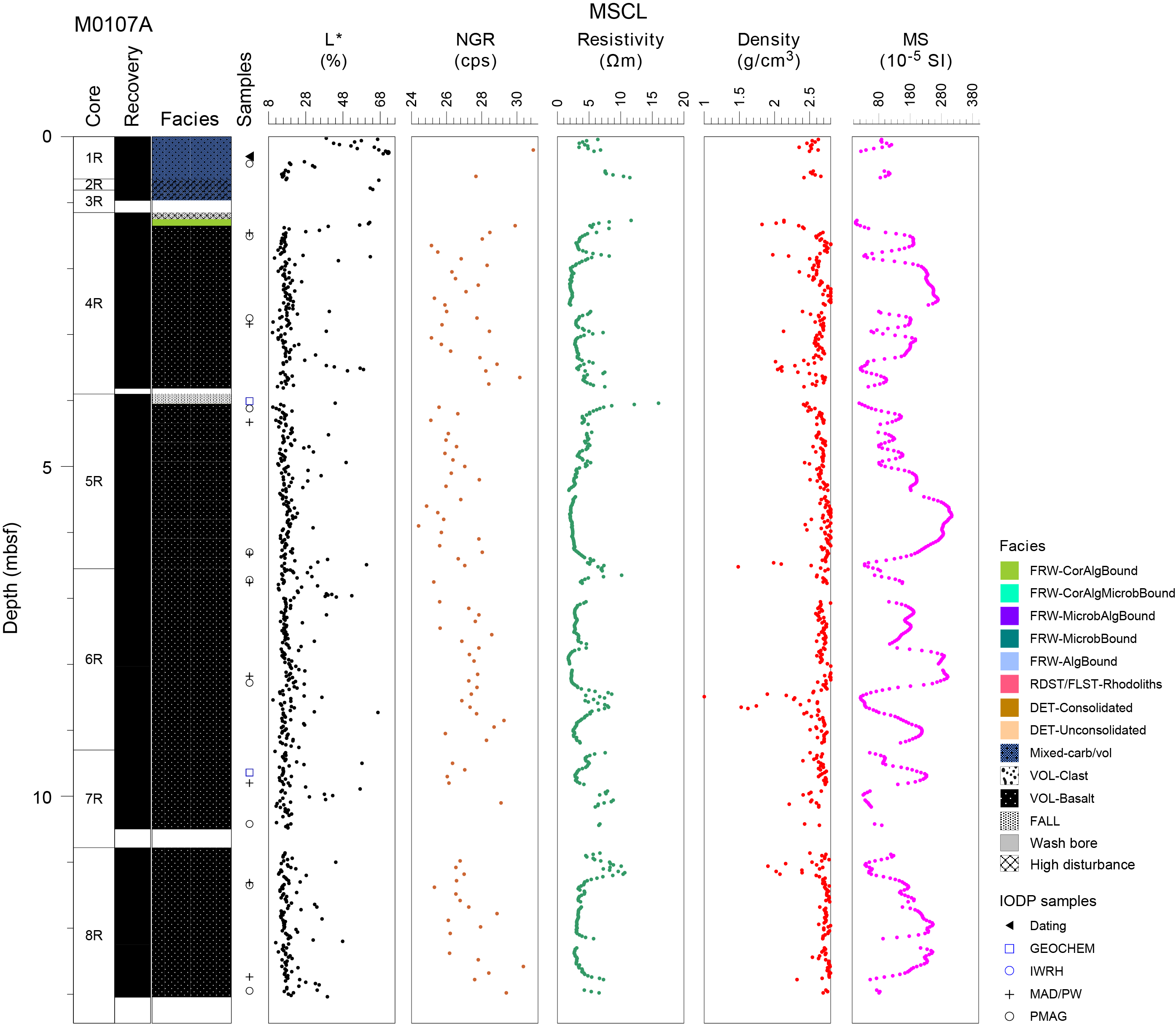
Figure F1. Lithostratigraphy and MSCL data.
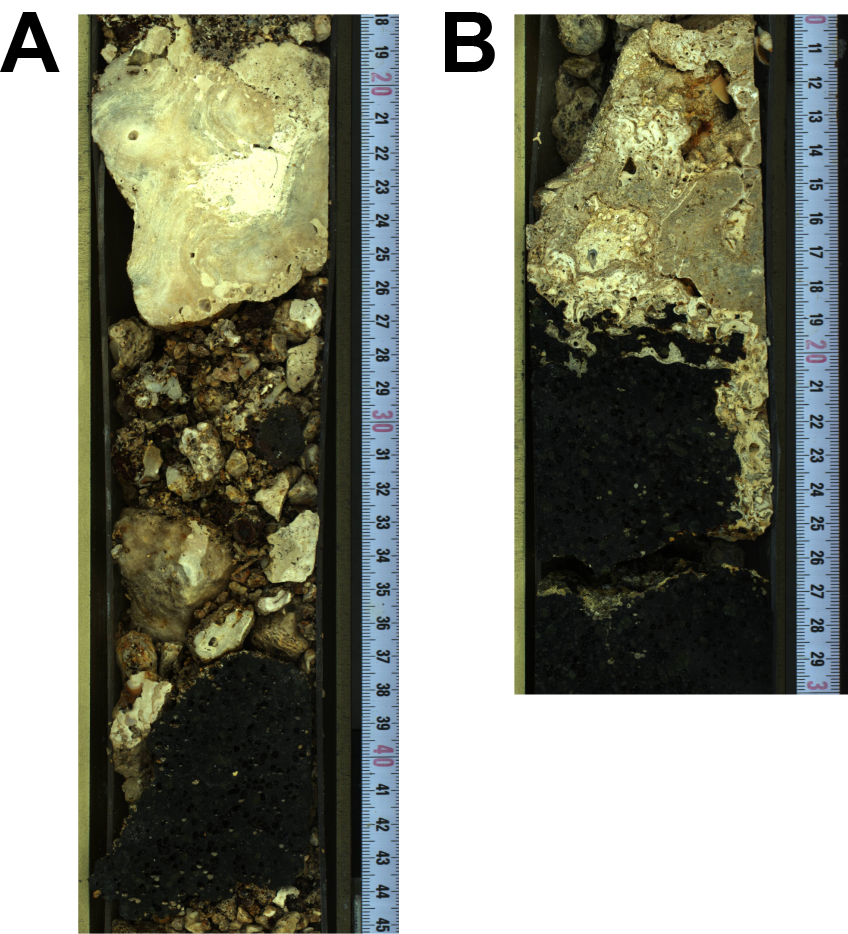
Figure F2. Lithologies.
Starting in Section 389-M0107A-4R-1 at 1.35 mbsf and continuing through Section 8R-2 to 13.05 mbsf, the cores mainly comprise lava: highly porphyritic (25–40 vol% phenocrysts) with crystals of olivine and clinopyroxene in a microcrystalline matrix containing rounded, 1–3 mm diameter vesicles (10–20 vol%). Many phenocrysts are euhedral, with examples ranging up to 10 mm in the longest expressed dimension (Figure F3A). The matrix is generally fresh and unaltered, although zones occur where calcite infills cracks and voids (Figure F3B). Additionally, there are zones near the upper parts of this lava where apparently syn-eruptive lava changes, possibly between lobes of the same flow, and shows textural variations consistent with cooling horizons that are infilled more substantially with calcite (Figure F3C).
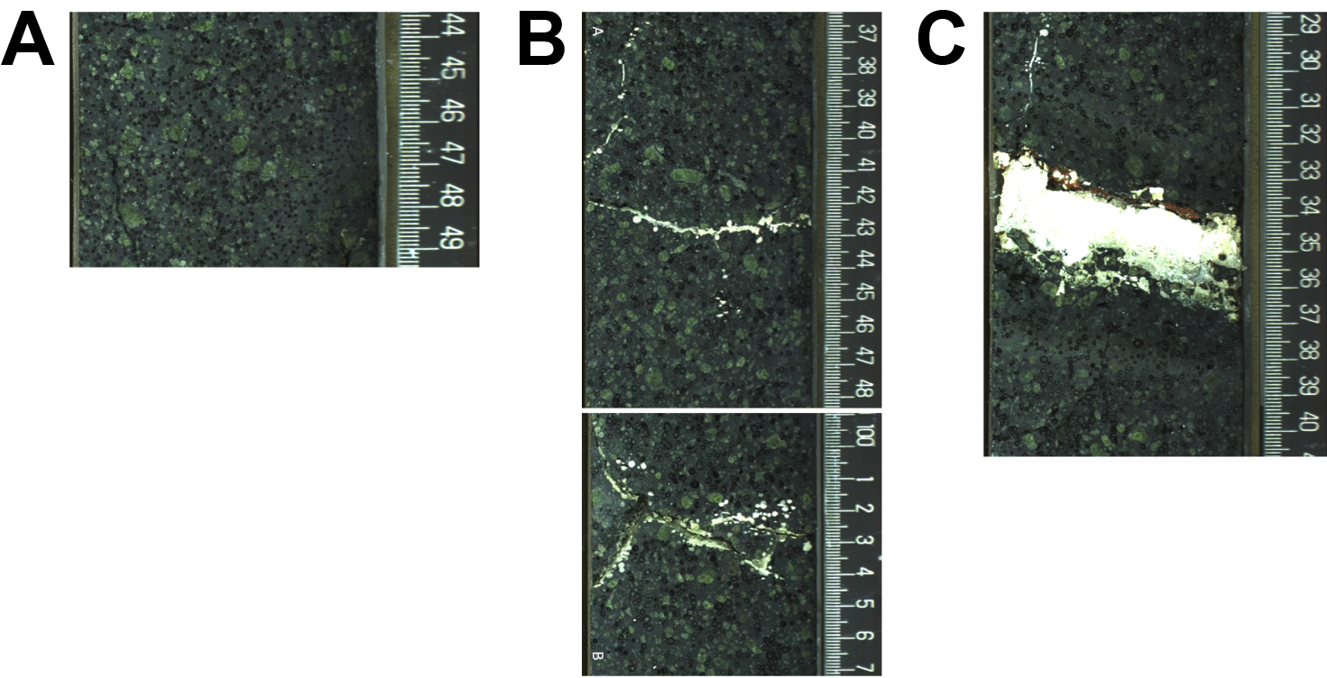
Figure F3. Lava.
The lava is disrupted by intervals of carbonate crusts or significant carbonate sediments infilling into upper lava surfaces at 2.94–2.97, 3.39–3.58, and 3.79–3.82 mbsf in Section 389-M0107A-4R-2 (the deepest horizon continues to 4.12 and 4.39–4.47 mbsf in Section 5R-1, 6.45–6.50 mbsf in Section 5R-2, 6.91–6.98 mbsf in Section 6R-1, 8.49–8.56 and 8.72–8.73 mbsf in Section 6R-2, 9.89–10.00 mbsf in Section 7R-1, 11.05–11.09 and 12.18–12.20 mbsf in Section 8R-1, and 12.81–12.85 mbsf in Section 8R-2).
3. Physical properties
Physical properties data for Site M0107 are shown in Table T2 in the Site M0096 chapter (Webster et al., 2025b).
3.1. Hole M0107A
A total of 12.35 m of core from Hole M0107A was scanned with the multisensor core logger (MSCL), and because the core exhibited only minor drilling-induced disturbance (mostly at the top in the sedimentary unit above 1.35 mbsf), 84% of the acquired data passed QA/QC (see Table T10 in the Expedition 389 methods chapter [Webster et al., 2025a]). A total of nine discrete samples were taken for P-wave velocity and moisture and density (MAD) measurements. Digital linescans, color reflectance, and hyperspectral imaging were acquired on all cores.
3.1.1. Density and porosity
Density and porosity data are presented in Figures F1 and F4. MSCL bulk density measurements range 0.99–2.89 g/cm3. A total of nine discrete samples were analyzed for MAD, giving bulk density values in the range of 2.57–2.74 g/cm3. Porosity values for the same samples range 10.8%–18.5%, and grain density values range 2.804–3.040 g/cm3. There are no clear downhole trends in the density and porosity data sets. There is good agreement between the two bulk density measurements (MSCL and discrete).
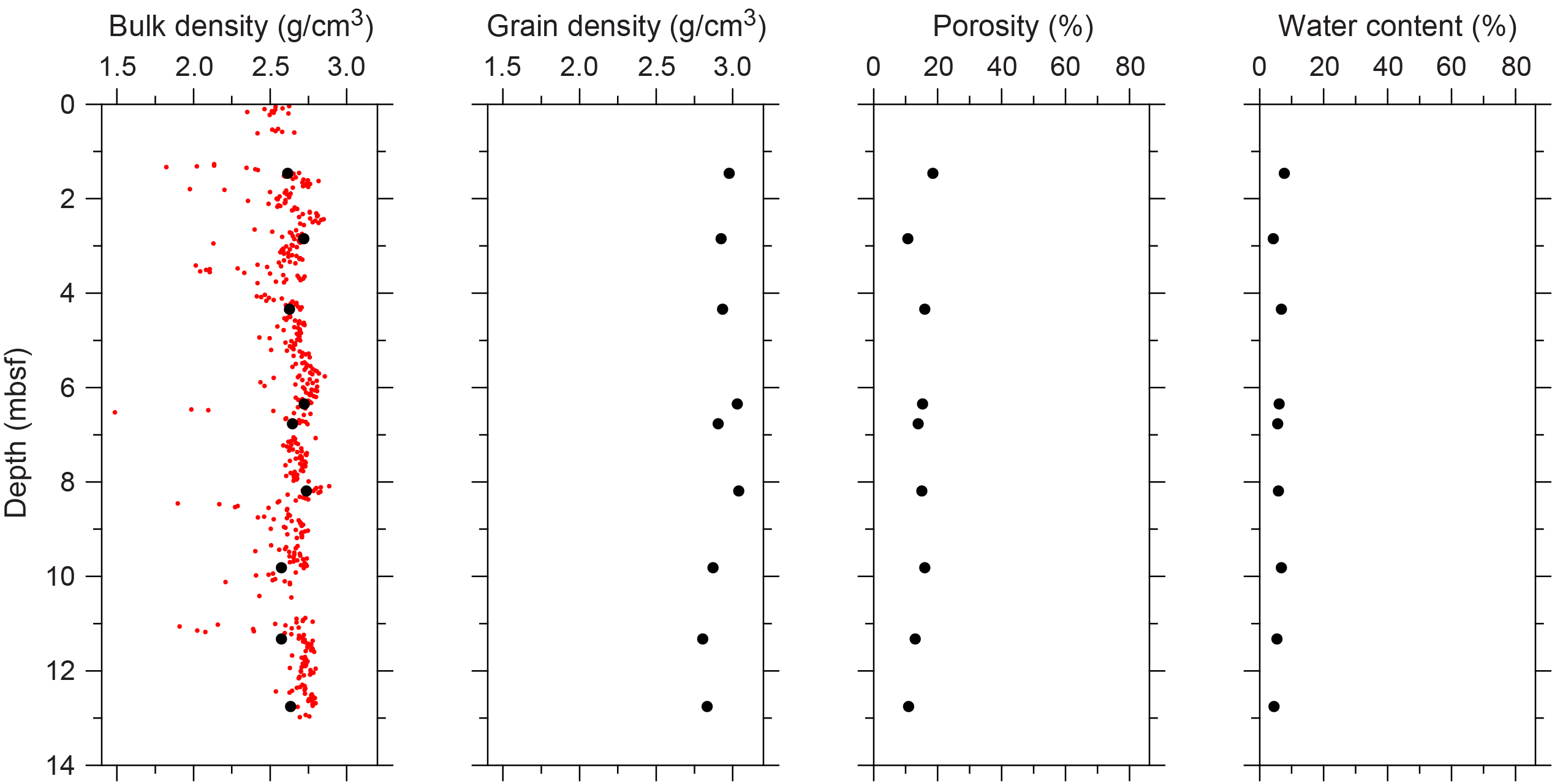
Figure F4. Physical properties.
3.1.2. P-wave velocity
MSCL P-wave velocity measurements yielded no data. A total of nine samples were measured using the discrete P-wave logger. P-wave velocity for dry and resaturated samples range 5014–6067 and 5682–6078 m/s, respectively (Figure F5). Initial velocity measurements, all from lava samples, range 6004–7426 m/s, which represent some of the highest velocities of the expedition. There is no apparent downhole trend in the P-wave data.
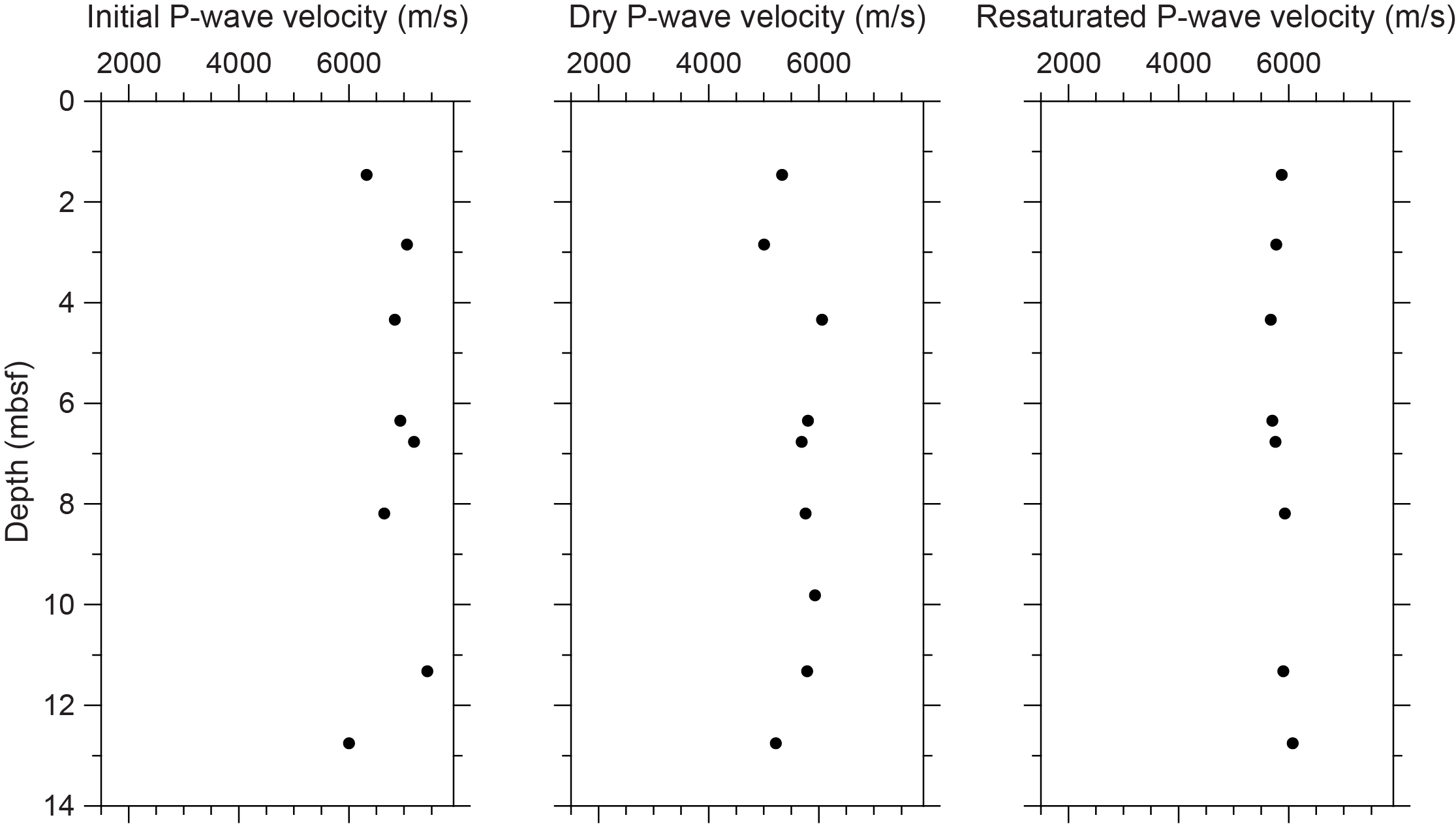
Figure F5. P-wave velocities.
3.1.3. Thermal conductivity
A total of three thermal conductivity measurements were collected for two cores (see Table T11 in the Expedition 389 methods chapter [Webster et al., 2025a]) and range 1.980–2.126 W/(m·K).
3.1.4. Magnetic susceptibility
MSCL magnetic susceptibility data range 6.25 × 10⁻⁵ to 313.91 × 10⁻⁵ SI (Figure F1), and the majority of magnetic susceptibility values fall close to 159.08 × 10⁻⁵ SI. There are oscillations in magnetic susceptibility, some of which are as large as 200 × 10−5 SI. Below Section 389-M0107A-4R-1, cores mainly comprise lavas but have carbonate crusts, carbonate infilling into upper lava surfaces, and/or variations in phenocryst volume (see Lithostratigraphy) that may influence the trends in magnetic susceptibility.
3.1.5. Electrical resistivity
MSCL noncontact resistivity measurements range 1.73–15.98 Ωm (Figure F1). Most of the resistivity values are close to 4.11 Ωm.
3.1.6. Natural gamma radiation
MSCL natural gamma radiation measurements range 24–31 counts/s (Figure F1) and show no apparent downhole trends.
3.1.7. Digital linescans, color reflectance, and hyperspectral imaging
All cores were digitally scanned, measured for color reflectance (where appropriate), and imaged with the hyperspectral scanner (see HYPERSPECTRAL in Supplementary material). Color reflectance L* values vary between 15.09% and 72.29%, a* varies between −0.86 and 5.08, b* varies between 1.73 and 23.82, and a*/b* varies between −0.22 and 0.28 (Figure F1).
4. Geochemistry
4.1. Interstitial water
No interstitial water samples were collected from Site M0107.
4.2. Surface seawater
One surface seawater sample was collected from Site M0107 using a Niskin bottle deployed from the side of the vessel (see Figure F22 in the Expedition 389 methods chapter [Webster et al., 2025a]). Parameters including salinity, pH, alkalinity, and concentrations of ammonium were analyzed off shore, and major cations and anions were measured during the Onshore Science Party. The salinity, pH, alkalinity, ammonium, and major element chemistry measured for this sample are consistent with the other surface seawater samples taken during Expedition 389 and align with the expected values for conservative elements in seawater (see Tables T15 and T17 in the Expedition 389 methods chapter [Webster et al., 2025a]).
4.3. Bulk sediment and rocks
Two bulk sediments were taken from Hole M0107A (Figure F1) and analyzed for mineralogy, elemental composition, and carbon content. Samples were derived from mixed sediment and basalt.
4.4. Mineralogy
The mixed sediment sample from 4.01 mbsf (389-M0107A-5R-1, 11–13 cm) is composed of high-Mg calcite (66%) and aragonite (33%). The basalt sample from 9.64 mbsf (7R-1, 34–36 cm) is composed of plagioclase (52%) and pyroxene (49%) (Table T2).
4.5. Elemental abundances
The elemental compositions of the two samples from Hole M0107A vary due to their differing mineral phases (Table T3). The sediment sample from 4.01 mbsf (5R-1, 11–13 cm) contains 334,172 mg/kg Ca, 36,192 mg/kg Mg, 122 mg/kg Mn, 2,384 mg/kg Sr, and 1,555 mg/kg Fe. Silicon and Al are below detection. The lava rock sample from 9.64 mbsf (7R-1, 34–36 cm) contains 42,461 mg/kg Ca, 92,775 mg/kg Mg, 1,027 mg/kg Mn, 180,493 mg/kg Si, 178 mg/kg Sr, 51,980 mg/kg Al, and 70,639 mg/kg Fe.
4.6. Carbon content
The basalt sample (389-M0107A-7R-1, 34–36 cm) contains 0.7% total carbon (TC), 0.11% total organic carbon (TOC), and 0.6% total inorganic carbon (TIC). The sediment sample (5R-1, 11–13 cm) contains 11.7% TC, 0.15% TOC, and 11.6% TIC (Table T4).
5. Paleomagnetism
A total of 10 plug samples were obtained from Hole M0107A. Measurements of low-field and mass-specific magnetic susceptibility (χ) were carried out for all samples. Natural remanent magnetization (NRM) was measured for all samples, as well as remanence following stepwise alternating field (AF) demagnetization up to a peak AF of 100 mT. For further details, see Paleomagnetism in the Expedition 389 methods chapter (Webster et al., 2025a).
5.1. Hole M0107A
A total of 10 lava samples were taken from Hole M0107A. High positive χ values occur throughout, ranging 2.53 × 10⁻⁶ to 11.9 × 10⁻⁶ m3/kg with an arithmetic mean of 5.41 × 10⁻⁶ m3/kg. The initial NRM intensity for 0 mT ranges 2.62 to 15.7 A/m with an arithmetic mean of 7.61 A/m. χ and NRM values generally vary similarly throughout the hole, except for the sample at 6.32 mbsf (5R-2, 90–92.5 cm), suggesting that concentration and properties of magnetic particles mainly drive these variations (Figure F6).

Figure F6. MS and NRM.
6. Geochronology
One U-Th date was measured on a sample from Hole M0107A; it was not rejected and yielded a date of ~130 ky BP (see Tables T21 and T22 in the Expedition 389 methods chapter [Webster et al., 2025a]). This date is younger than the estimated Marine Isotope Stage 6/7 age of the H2 terrace, sitting on the boundary of Marine Isotope Stages 5 and 6 (Ludwig et al., 1991; Webster et al., 2009).
References
Ludwig, K.R., Szabo, B.J., Moore, J.G., and Simmons, K.R., 1991. Crustal subsidence rate off Hawaii determined from 234U/238U ages of drowned coral reefs. Geology, 19(2):171–174. https://doi.org/10.1130/0091-7613(1991)019<0171:CSROHD>2.3.CO;2
Webster, J.M., Braga, J.C., Clague, D.A., Gallup, C., Hein, J.R., Potts, D.C., Renema, W., Riding, R., Riker-Coleman, K., Silver, E., and Wallace, L.M., 2009. Coral reef evolution on rapidly subsiding margins. Global and Planetary Change, 66(1–2):129–148. https://doi.org/10.1016/j.gloplacha.2008.07.010
Webster, J.M., Ravelo, A.C., Grant, H.L.J., and the Expedition 389 Scientists, 2025. Supplementary material, https://doi.org/10.14379/iodp.proc.389supp.2025. In Webster, J.M., Ravelo, A.C., Grant, H.L.J., and the Expedition 389 Scientists, Hawaiian Drowned Reefs. Proceedings of the International Ocean Discovery Program, 389: College Station, TX (International Ocean Discovery Program).
Webster, J.M., Ravelo, A.C., Grant, H.L.J., Rydzy, M., Stewart, M., Allison, N., Asami, R., Boston, B., Braga, J.C., Brenner, L., Chen, X., Chutcharavan, P., Dutton, A., Felis, T., Fukuyo, N., Gischler, E., Greve, S., Hagen, A., Hamon, Y., Hathorne, E., Humblet, M., Jorry, S., Khanna, P., Le Ber, E., McGregor, H., Mortlock, R., Nohl, T., Potts, D., Prohaska, A., Prouty, N., Renema, W., Rubin, K.H., Westphal, H., and Yokoyama, Y., 2025a. Expedition 389 methods. In Webster, J.M., Ravelo, A.C., Grant, H.L.J., and the Expedition 389 Scientists, Hawaiian Drowned Reefs. Proceedings of the International Ocean Discovery Program, 389: College Station, TX (International Ocean Discovery Program). https://doi.org/10.14379/iodp.proc.389.102.2025
Webster, J.M., Ravelo, A.C., Grant, H.L.J., Rydzy, M., Stewart, M., Allison, N., Asami, R., Boston, B., Braga, J.C., Brenner, L., Chen, X., Chutcharavan, P., Dutton, A., Felis, T., Fukuyo, N., Gischler, E., Greve, S., Hagen, A., Hamon, Y., Hathorne, E., Humblet, M., Jorry, S., Khanna, P., Le Ber, E., McGregor, H., Mortlock, R., Nohl, T., Potts, D., Prohaska, A., Prouty, N., Renema, W., Rubin, K.H., Westphal, H., and Yokoyama, Y., 2025b. Site M0096. In Webster, J.M., Ravelo, A.C., Grant, H.L.J., and the Expedition 389 Scientists, Hawaiian Drowned Reefs. Proceedings of the International Ocean Discovery Program, 389: College Station, TX (International Ocean Discovery Program). https://doi.org/10.14379/iodp.proc.389.103.2025