MacLeod, C.J., Dick, H.J.B., Blum, P., and the Expedition 360 Scientists
Proceedings of the International Ocean Discovery Program Volume 360
publications.iodp.org
doi:10.14379/iodp.proc.360.105.2017

Hole U1473A remediation operations, Expedition 362T1
P. Blum, C.J. MacLeod, H.J.B. Dick, N. Abe, D.K. Blackman, J.A. Bowles, M.J. Cheadle, K. Cho, J. Ciążela, J.R. Deans, V.P. Edgcomb, C. Ferrando, L. France, B. Ghosh, B.M. Ildefonse, M.A. Kendrick, J.H. Koepke, J.A.M. Leong, C. Liu, Q. Ma, T. Morishita, A. Morris, J.H. Natland, T. Nozaka, O. Pluemper, A. Sanfilippo, J.B. Sylvan, M.A. Tivey, R. Tribuzio, and L.G.F. Viegas2
Keywords: International Ocean Discovery Program, IODP, JOIDES Resolution, Expedition 362T, Expedition 360, Site U1473, Southwest Indian Ridge, Atlantis Bank
MS 360-105: Published 30 January 2017
Summary
International Ocean Discovery Program (IODP) Expedition 362T was part of the transit from the April–June 2016 tie up in Cape Town, South Africa, to the IODP Expedition 362 port call in Colombo, Sri Lanka, (4 July–6 August 2016). Hole U1473A remediation operations, approved in March 2016 by the JOIDES Resolution Facility Board (JRFB), took place 12–21 July 2016. The objectives of the Expedition 362T remedial operations were to remove the mechanical bit release retainer sleeve (MBR-RS) left at the bottom of Hole U1473A at the end of IODP Expedition 360, cement multiple fault zone intervals to stabilize them, obtain a borehole temperature log across the fault zones (at the beginning of operations), and deepen the hole by coring an interval of no more than ~20 m.
The planned temperature logging run at the beginning of operations was only partially successful because the logging tool could not be lowered below a ledge at 277 m wireline log depth below seafloor (WSF). Subsequent reaming using two tricone bit runs established a clean hole free of debris to the total depth of 789.7 m drilling depth below seafloor (DSF) established during Expedition 360. The fishing run with the reverse circulation junk basket (RCJB) yielded a surprise: it deepened Hole U1473A by 0.5 m and no junk was present at the bottom of the hole (i.e., the MBR-RS must have been removed with the last RCJB run during Expedition 360 and fallen to the seafloor without leaving any operational evidence). Next, four coring intervals deepened Hole U1473A by another 19.2 m, recovering 16.55 m (86%). The last task, cementing four fault zones identified in cores and mapped precisely based on Expedition 360 wireline logs, was partly successful. We completely cemented the lowermost fault zone (584–500 m DSF) and partly cemented the second lowest and most intense fault zone (489–443 m DSF). The upper two, less severe fault zones were not cemented at all.
In summary, Hole U1473A is stable, clean of junk, and ready for deepening during a future expedition.
Introduction
Hole U1473A, located at 32°42.3622′S, 057°16.6880′E in the central part of the Atlantis Bank on the Southwest Indian Ridge at 710.2 m water depth, was drilled during Expedition 360 (30 November 2015–30 January 2016) to a total depth of 789.7 m DSF with 469.2 m of gabbroic rocks recovered (see the Expedition 360 summary and Site U1473 chapters [Dick et al., 2017; MacLeod et al., 2017b]). Following coring, wireline logs were successfully acquired on 23–25 January. Logging operations included the use of a mechanical bit release (MBR), which saved the time of a full pipe trip before logging by dropping the bit on the seafloor next to the reentry system. When the pipe was retrieved after completion of logging, the MBR-RS, a steel ring that is part of the bit release mechanism made up with the bottom-hole assembly (BHA), was missing and presumed lost in the hole. Subsequent runs on 25–26 January with the rotary core barrel (RCB) coring bit and the RCJB confirmed that the MBR-RS was at the bottom of the hole (see Figure F11 in the Site U1473 chapter [MacLeod et al., 2017b]). At that point, no more time was available for operations during Expedition 360.
Given that the JOIDES Resolution Science Operator (JRSO) operations schedule had the R/V JOIDES Resolution tied up in Cape Town, South Africa, from April through June 2016 and that the subsequent transit to Colombo, Sri Lanka, to begin Expedition 362 sailed right over Site U1473 for all practical purposes, the Expedition 360 Co-Chief Scientists submitted a request to the JRFB to spend several days cleaning the junk out of Hole U1473A, cementing four fault zones encountered during Expedition 360, and taking a few additional cores to establish the feasibility of a return to deepen Hole U1473A during a future science expedition. The request was approved on 8 March 2016 with the following caveat: “…once the hole has been cleaned, its condition should be safeguarded to the maximum extent possible. This means we [the JRFB] only have approved deepening of the hole by coring up to a maximum of 20 m (instead of the 100 m proposed). This will be sufficient to determine whether the hole is in optimal drilling condition.”
Objectives
The primary objective of the Expedition 362T remedial operations was to remove the MBR-RS at the bottom of the hole. Additional objectives included cementing multiple fault zone intervals to stabilize them, obtaining a borehole temperature log across the fault zones (at the beginning of operations), and deepening the hole by coring an interval of no more than ~20 m.
Several fault zones were encountered while coring in Hole U1473A during Expedition 360. These zones were identified by distinctive features in the recovered rocks and log data and by intervals of lower than expected core recovery. Fault zones were precisely located by caliper, temperature, and resistivity wireline log data between 160 and 580 m wireline log matched depth below seafloor (WMSF). Deeper than 580 m WMSF, log data and high core recovery indicate that Hole U1473A is very smooth and lacks faults (Figure F1). A secondary objective of the remedial operations was to cement the faulted intervals in the hope of stabilizing the upper part of the hole, in particular to prevent debris from falling onto the bit and/or BHA during future coring.
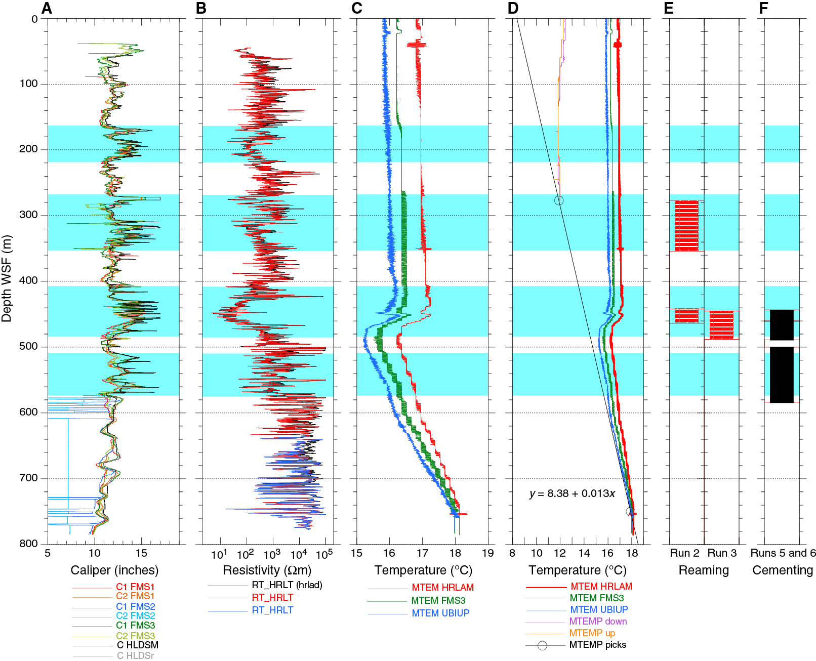
Figure F1. Summary of selected logging data, Expeditions 360 and 362T.
A borehole temperature anomaly in the Expedition 360 log data correlates with the most intensely faulted zone at 430–470 m WMSF (Figure F1). During Expedition 362T, we attempted a temperature log to learn how that signal has evolved since we logged Hole U1473A in January 2016.
Our last objective was to deepen Hole U1473A by coring up to 20 m, a limit imposed by the JRFB to minimize the risk of compromising the cleaned hole.
A total of 9 days of remedial operations were allocated, with 4 additional days of contingency time given the potentially disruptive weather during this season. The following was the sequence of planned operations:
- Enter the hole with a temperature logging string and acquire temperature data (~1.2 days).
- Attempt to recover the MBR-RS, starting with the RCJB, which successfully retrieved two roller cones during Expedition 360 (e.g., Figure F7 in the Site U1473 chapter [MacLeod et al., 2017b]). In the best-case scenario, we would retrieve the ring during the first attempt (~0.6 days). Multiple tool runs were possible with the RCJB, the fishing magnet, and/or a milling tool. In the worst case, the entire available time would be used to keep fishing and/or milling.
- As soon as the hole is clear of the MBR-RS, attempt to cement multiple fault intervals between 580 and 160 m DSF identified in the Expedition 360 log data (~0.9 days).
- After cementing is complete, drill through the cement plugs and ~5 m into the formation at the bottom of the hole using a tricone noncoring bit (~3.9 days).
- If time is still available, switch to an RCB coring bit and cut two cores (~1.2 days).
Furthermore, the plan was to curate any material recovered from the hole per standard operating procedures, take the same whole-round section measurements (imaging, magnetic susceptibility loop sensor [MSL], gamma ray attenuation [GRA] density, and natural gamma radiation [NGR]) and section half measurements (images, point magnetic susceptibility [MSP], reflectance spectroscopy and colorimetry [RSC], and magnetic remanence) as were taken during Expedition 360, and store all recovered material on the JOIDES Resolution and ship it to the Kochi Core Center (KCC) at the end of Expedition 362 (October 2016), where they will be made available to the Expedition 360 science party for detailed description and postcruise research.
Transit
Expedition 362T began on 4 July 2016 in Cape Town, South Africa. We completed the 2080 nmi of transit at an average speed of 11.2 kt and arrived at Site U1473 at 1315 h on 12 July. By 1415 h, the thrusters, hydrophones, and beacon were deployed. During the transit, ship local time was adjusted in four increments to Sri Lanka time (UTC + 5.5 h).
Logging
A logging BHA was made up and deployed to the seafloor. The subsea camera was deployed, and at 1900 h on 12 July 2016, Hole U1473A was reentered for the first time during Expedition 362T and for the twenty-fifth time overall (Tables T1, T2). The camera was retrieved and the logging bit was set at 75.6 m DSF in preparation for logging. We made up and deployed a temperature and NGR logging tool string; by midnight, downhole logging had just begun.
Table T1. Site U1473 core summary, Expedition 362T. Download table in .csv format. View PDF table.
Table T2. Expedition 362T operational summary information by BHA run number, Hole U1473A. Download table in .csv format.
Temperature and NGR logs were acquired while the logging tool string descended into Hole U1473A. At midnight, the tool string had reached 276.7 m WSF, where a bridge or ledge in the hole prevented further descent. We acquired log data while pulling the tool to the seafloor then retrieved the tool string and rigged it down by 0200 h. We lowered the drill string to find out if the obstruction could be knocked down with the logging bit, in the hope that another, deeper logging run could be attempted. However, the bit could not be lowered beyond a hard tag at 276 m DSF. We pulled the drill string and the bit was back on the rig floor at 0700 h on 13 July. We spent 0.7 days logging compared to the planned 1.2 days.
The new log data from the upper 277 m of Hole U1473A show significantly lower temperatures (11.8°C) than the same interval had during Expedition 360 (16°–17°C; Figure F1D). However, just as observed in January during Expedition 360, the interval had almost constant temperature in July (slightly warmer by ~0.5°C toward the top), without an expected geothermal gradient similar to that in the lowermost 250 m of the hole. Although the new data acquired do not provide data across the fault zones that extend to 580 m DSF, they may nevertheless offer a constraint for thermal modeling and the role of thermal diffusion and convection.
Fishing for the lost MBR retainer sleeve
Next, we made up a 9¾ inch tricone drilling assembly to try to reach the bottom of the hole using a cautious procedure involving rigorous use of circulation and mud sweeps (bit Run 2). At 1257 h on 13 July 2016, we reentered Hole U1473A for the second time during this expedition (twenty-sixth reentry overall; Table T2) and engaged the top drive. The hole was reamed and swept from 277 to 354 m DSF and reached depth at 0145 h, using three 30-barrel high-viscosity mud sweeps at 280, 320, and 331 m DSF. From there on, we were able to trip the pipe to 442 m DSF with the top drive engaged. Lowering the drill string further with the top drive disengaged, drag was encountered and the bit tagged another obstruction at 464 m DSF, the base of the main fault zone (Figure F1), at 0345 h on 14 July. We reengaged the top drive and reamed the interval from 442 to 456 m DSF for more than 7 h, pumping four 30-barrel high-viscosity mud sweeps. We were not able to advance farther. At 1130 h on 14 July, we decided to trip the pipe so that we could assess the wear on the bit and draw conclusions on the situation in the obstruction interval. The bit was back on the rig floor at 1530 h. It showed the common abrasion of the peripheral cutters and signs of bearing damage. Moreover, it had broken cutters on the inner rows of the cones (Figure F2A–F2B), indicating contact with an angular object in the center of the hole. This object was unlikely to be metal (i.e., one of the two broken-off roller cones probably left in the hole during Expedition 360), because that would have damaged the matrix of the tricone bit’s cones.
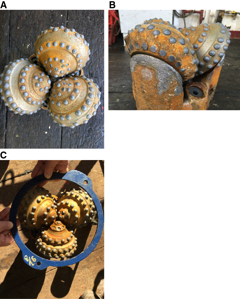
Figure F2. Tricone bit condition after reaming.
A new tricone bit was made up and deployed to the seafloor, reentering Hole U1473A for the third time at 2100 h on 14 July (bit Run 3). The drill string was lowered without a problem until it tagged the bridge at 445 m DSF. The top drive was engaged, and drilling resumed at 2400 h. We continued to ream and work Hole U1473A with the second tricone drilling assembly, which took 0.5 days to advance from 445 to 471 m DSF along with pumping four 30-barrel high-viscosity mud sweeps at 449, 459, 462, and 471 m DSF. From 1200 to 1300 h on 15 July, we advanced more rapidly to 487.6 m DSF, experiencing significant torque and drag, and finally breaking through the bridge. We continued to lower the bit with the top drive engaged so that we could circulate mud sweeps at 490, 530, 580, 650, and 720 m DSF. At 0115 h on 16 July, we reached the bottom of the hole established during Expedition 360 (789.7 m DSF). No fill was identified at the bottom of the hole. Two 50-barrel high-viscosity mud sweeps, followed by twice the hole volume of water, were circulated to sweep cuttings out of the hole.
At 0245 h, we began a wiper trip by raising the bit first to 731 m DSF, where the top drive was disengaged, and then to 147 m DSF (0500 h). Next, the pipe was lowered again: first to 760 m DSF, where the top drive was reengaged, then to the bottom of the hole at 789.7 m DSF (1045 h). No rotation with the top drive was needed, which indicated good hole conditions. Finally, the drill pipe and tricone bit assembly were recovered: first to 760 m DSF, where the top drive was disengaged, and then to the surface, with the bit arriving on the rig floor at 1500 h on 16 July.
Inspection of the tricone bit revealed the same broken-off cutter inserts on the inner row as were seen in the first tricone bit. The bit was ~0.25 inches out of gauge (Figure F2C). The remainder of the bit was in good condition.
Given the good hole conditions, we decided hours earlier that cementing the fault zones was not necessary or helpful to stabilize the hole at that time. We made up an RCJB assembly (1530–2015 h) to try to recover the MBR-RS presumably left at the bottom of the hole at the end of Expedition 360. At 2015 h, we began deploying the RCJB assembly (bit Run 4), and Hole U1473A was reentered for the fourth time during this expedition (twenty-eighth reentry overall; Table T2) at 2106 h on 16 July. We continued to lower the RCJB assembly to 763 m DSF without the top drive and from 763 m to the bottom of the hole at 789.7 m DSF with the top drive engaged. At 0145 h on 17 July, a 30-barrel high-viscosity mud sweep was circulated before the RCJB was worked up and down three times by ~2 m with heavy circulation on and off to capture remaining small debris in the tandem boot baskets located above the main basket with mill guide. Next, the reverse circulation activating steel ball was dropped down the pipe, and with heavy circulation and high rotation rate (~80 rotations/min) the mill guide was advanced into new formation by 0.5 m (0145–0330 h). The drill pipe and RCJB assembly were subsequently retrieved: first with the top drive to 763 m DSF then without the top drive to the rig floor (0330–0750 h). No drag or overpull was registered during the ascent.
Breaking down the RCJB components, we found the tandem boot baskets empty, indicating a clean hole. Next, we extracted an 18 cm diameter by 36 cm long solid rock core from the main basket (Core 362T-U1473A-92M; Figure F3). The mill guide showed expected wear but no damage from the feat of drilling the “fat core”). We found no sign of the missing MBR-RS.
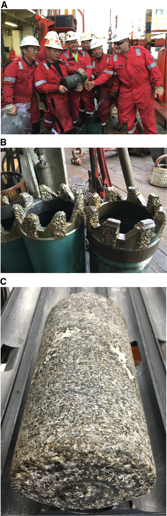
Figure F3. RCJB fishing run fat core.
This was an unexpected situation because we were certain that (1) the MBR-RS was at the bottom of the hole when we deployed the RCJB with the last bit Run 24 during Expedition 360 based on the observation that multiple tool marks on three cobbles retrieved with that run matched the MBR-RS features exactly (see Figure F11 in the Site U1473 chapter [MacLeod et al., 2017b]), and (2) we drilled a new core with this latest RCJB bit Run 4 during Expedition 362T, and nothing could have been between the bit and the top of Core 362T-U1473A-92M based on the perfect tricone bit marks on top of Core 92M (Figure F3C). Our only explanation was that the MBR-RS was recovered out of the hole with the last run during Expedition 360 and fell out of the basket to the seafloor while the pipe was being tripped to the surface, whereas the cobbles remained inside the basket. The repeated acceleration and deceleration during pipe tripping may have separated steel from rock. This explanation could also apply to the two broken-off roller cones that were never accounted for during Expedition 360 or 362T.
Coring
Feeling confident that we had a very clean hole, we made up an RCB coring assembly (0945–1330 h on 17 July 2016) and reentered Hole U1473A for the fifth time during Expedition 362T (twenty-ninth reentry overall) at 1552 h on 17 July. The drill string was further lowered to 760 m DSF without the top drive and then to the bottom of the hole at 790.2 m DSF by 2100 h. By midnight, coring had advanced 4.8 m to 795.0 m DSF. This was the advance possible for this core based on rig space configuration, and we decided to core the remainder of the 20 m approved coring interval in three additional 4.8 m increments (half cores). Core 362T-U1473A-93R (790.2–795.0 m DSF) arrived on deck at 0205 h on 18 July with a recovery of 3.1 m (65%). We then cut Cores 94R through 96R (each penetrating 4.8 m), from 795 to 809.4 m DSF, with recoveries of 2.35, 7.32, and 3.78 m (49%, 153%, and 79%), respectively. The low recovery of Core 94R and excessively high recovery of Core 95R were the result of about half the core cut for Core 94R remaining at the bottom of the hole and Core 95R retrieving the stub left behind in addition to the newly cut core. At 1215 h on 18 July, the coring program approved for the Hole U1473A remediation project was concluded. The total RCB-cored interval was 19.2 m, and total recovery was 16.55 m (86%). Upon inspection, the RCB bit showed virtually no wear from the ~20 m interval of coring (Figure F4). Hole U1473A is ready for coring during a future expedition.
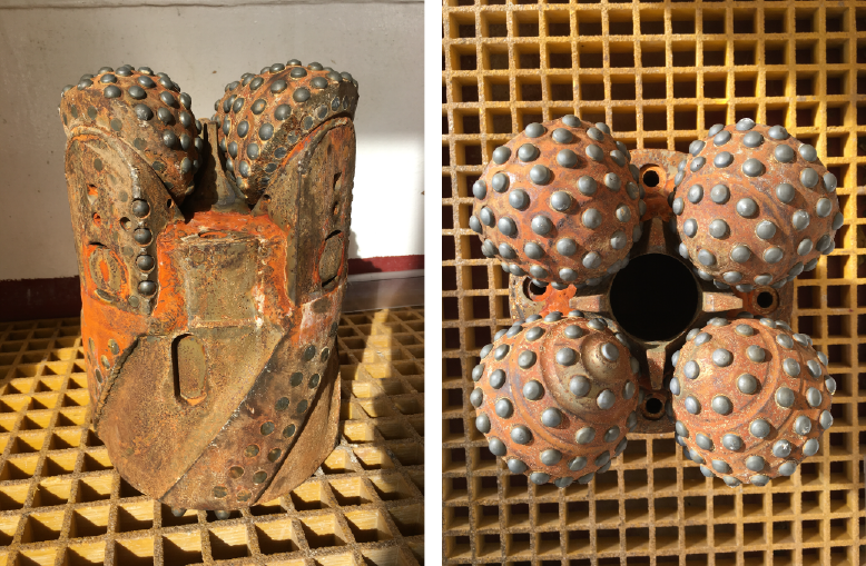
Figure F4. Rotary coring bit used during bit Run 5.
Cores were curated by arranging the pieces in ~1.5 m long sections and labeling and registering all pieces and sections. The core composite depth below seafloor (CCSF) depth scale constructed for the Expedition 360 cores (see the Expedition 360 methods chapter (MacLeod et al., 2017a) was extended for the Expedition 362T cores by adding the new cores and their shifts to the affine table (Table T3; see 362T in Supplementary material for a shifting method worksheet and the final affine table uploaded to the Laboratory Information Management System [LIMS] database). This “alternate depth scale” accommodates the 153% recovery of Core 95R based on the rule that if the total length of all curated sections in a core is greater than the cored interval, the core is shifted up by the excess length, the core above is shifted up accordingly, and so on until no more excess length exists.
Table T3. Affine table including cores recovered during Expedition 362T, Hole U1473A. Download table in .csv format.
Curated core sections were run through petrophysical core loggers and image loggers (Figures F5, F6) for whole-round sections and section halves. Following the same protocols as Expedition 360, the whole-round sections were first run on the Whole-Round Multisensor Logger to measure GRA bulk density and MSL, followed by NGR measurements with the Natural Gamma Radiation Logger. Next, we took images of the whole-round section surfaces using the appropriate configuration on the Section Half Imaging Logger (SHIL). The four quadrant images for each section were combined to create “unwrapped” composite images (Figure F6). After splitting the cores, we ran the archive halves on the SHIL for split surface images (Figure F6), which were combined in core composite images. The archive halves were also measured on the Section Half Multisensor Logger for MSP and RSC (Figure F5D, F5F).
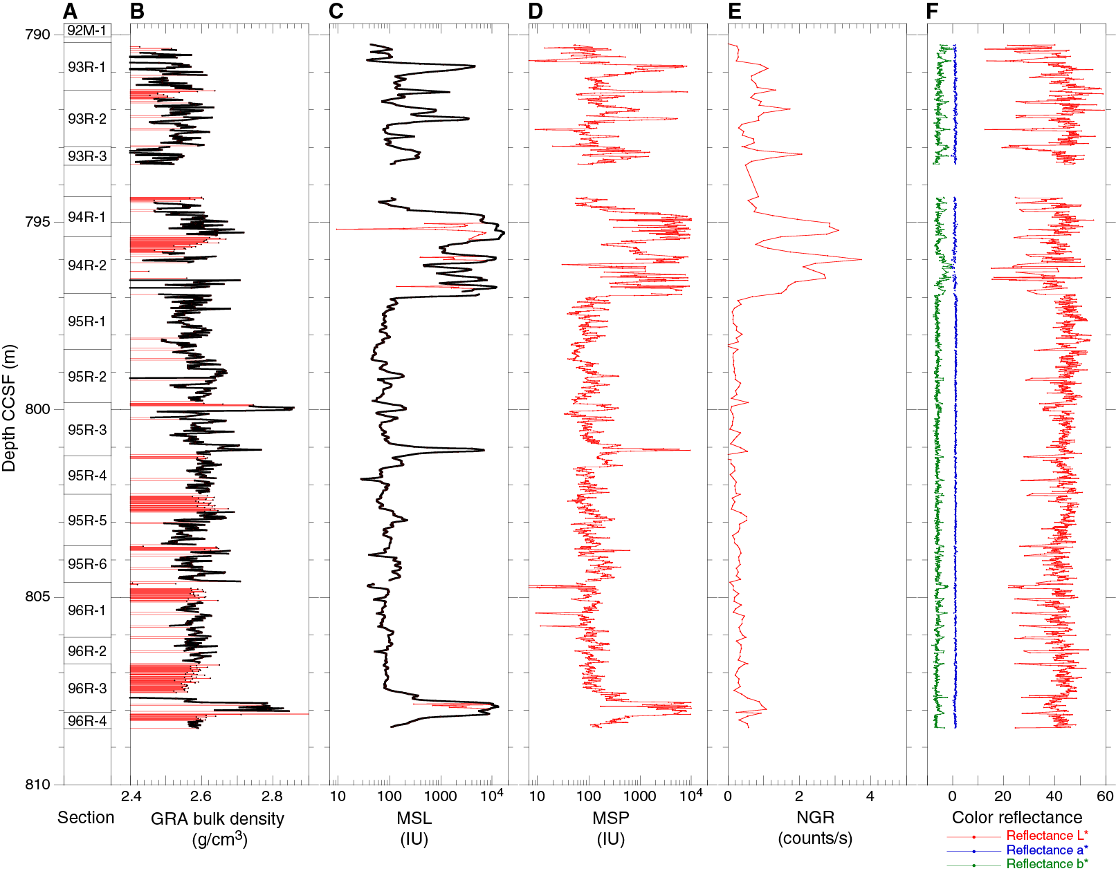
Figure F5. Core logging data, Expedition 362T.
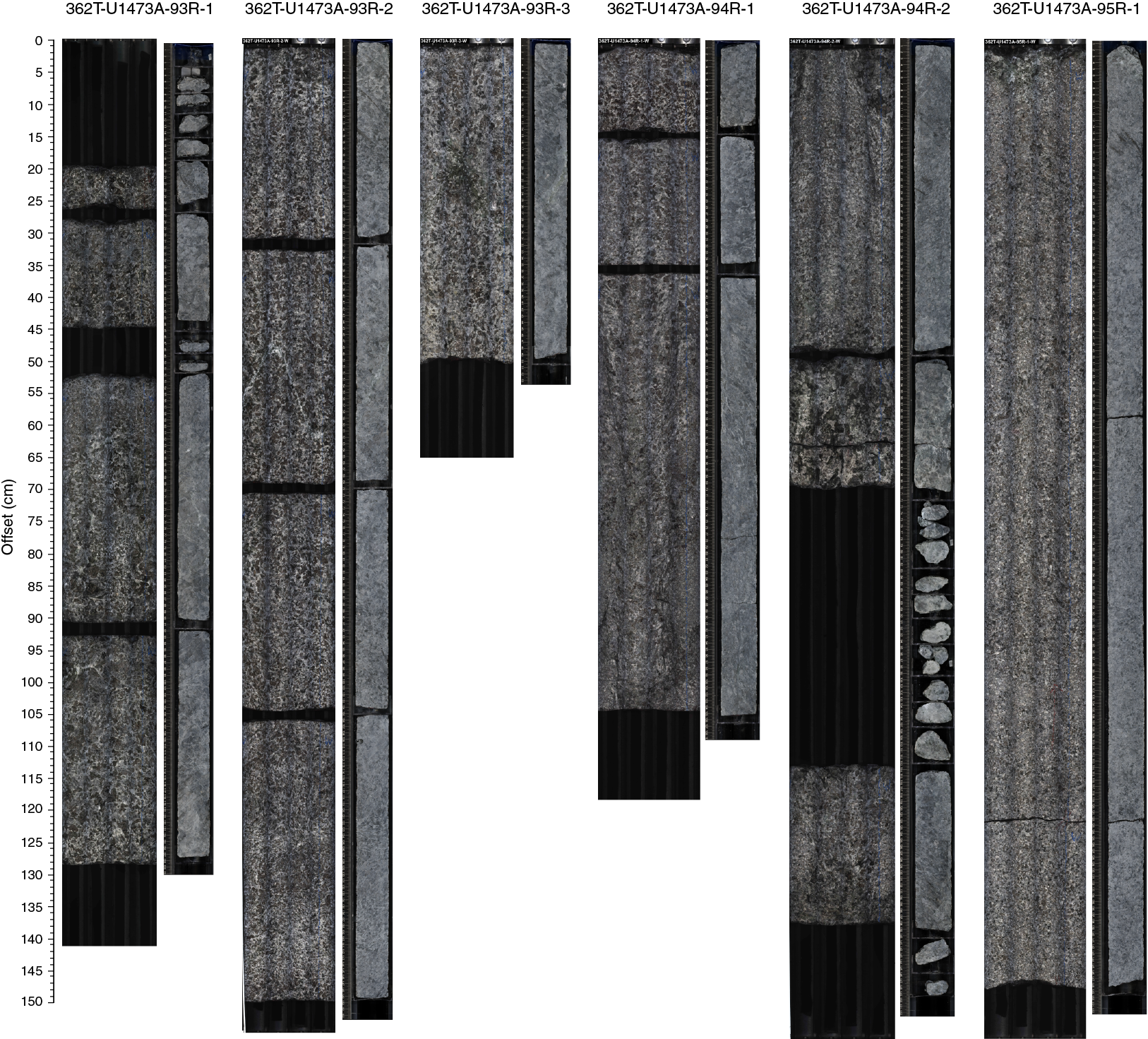

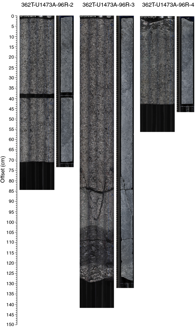
Figure F6. Whole-round and section half images.
Paleomagnetic measurements on archive section halves could not be taken because of issues with the superconducting rock magnetometer software. These issues were resolved during the early part of subsequent Expedition 362, and the 15 section halves were measured at that time (see 362T in Supplementary material for the data acquired during Expedition 362).
All core logging data are available from the online LIMS Reports at http://web.iodp.tamu.edu/LORE.
The new Cores 92M through 96R (789.7–809.4 m DSF; 789.7–808.5 m CCSF) consist mostly of medium- to coarse-grained subophitic olivine gabbro with a weak magmatic fabric and irregular contacts between medium- and coarse-grained size domains. In Core 94R (795–797 m CCSF), a zone of Fe-Ti oxide gabbro results in high magnetic susceptibility and significant NGR (Figure F5) with sheared contacts and an associated porphyroclastic interval (Figure F6). Cores 95R and 96R (deeper than 797 m CCSF; Figure F5) are more isotropic with low magnetic susceptibility and no NGR. In Sections 96R-3 to 96R-4 (~808 m CCSF), a 40 cm thick Fe-Ti oxide–rich mylonitic band is underlain by a porphyroclastic interval, indicating that zones of crystal-plastic deformation continue to the bottom of the hole.
Detailed descriptions of these cores, including those of thin sections yet to be sampled and prepared, will be carried out by a subgroup of the Expedition 360 science party at the KCC sometime in the future.
Cementing
At 1215 on 18 July 2016, the bit was raised to 585 m DSF and preparations were made for cementing the unstable faulted zones (Figure F1A). We decided to cement the four fault zones identified on Expedition 360 caliper logs in four separate installments rather than in one delivery as originally planned. This would allow us to tag the top of each cement plug after an appropriate curing time (~12–24 h), determine if the calculated volume was adequate to fill the target interval, and take corrective action if deemed necessary.
The first cement target interval was ~574–509 m DSF. We positioned the bit at 584 m DSF (10 m below the target), pumped 50 barrels of 16.8 lb/gal (ppg) Class G cement, and emplaced it with 680 barrels of seawater using the rig pumps (1430–1715 h). The volume of cement was 25% over the target interval capacity calculated using the caliper log to ensure filling of all cavities.
At 1715 h on 18 July, the cement circulation head was removed and the bit was raised to 381 m DSF. The drill string was flushed with three times the annular hole and pipe volume before it was further raised to ~84 m above the seafloor and flushed again with two times the pipe volume. The drill string was then retrieved, with the bit arriving on the rig floor at 2325 h on 18 July. This was still the same coring bit used to cut Cores 362T-U1473A-93R through 96R, and it showed no signs of damage or wear.
We began making up a tricone bit assembly, which is more suitable for cementing than the coring bit, with the intent to cement the other three cementing intervals, and deployed it to ~138 m above the seafloor. We then waited from 0215 until 0630 h on 19 July for the first cement interval to cure before reentering Hole U1473A for the sixth time during Expedition 362T (thirtieth reentry overall) at 0726 h on 19 July. The bit was lowered until it tagged the top of the first cement plug with 10,000 lb weight at 500 m DSF. This was 9 m above the target (i.e., the cement plug is filling an interval of ~84 m instead of the 65 m planned), which is an excellent result.
The second target interval for cementing was 484–409 m. We raised the bit to 489 m (5 m below the target) and initiated cement mixing and pumping. A plugged cement line forced us to abort this attempt and flush the low-density cement out of the hole (1045–1200 h). After the cementing lines were cleared, we started over, pumping 70.7 barrels of 15 ppg Class G cement and emplacing it with seawater (1200–1330 h). The drill string was pulled to 227 m DSF, flushed with two times the annular pipe and hole volume, and then pulled to ~112 m above the seafloor, where it was flushed once more with two times the pipe capacity (1330–1600 h). We waited for the cement in the second interval to cure before reentering Hole U1473A for the seventh time (thirty-first reentry overall) at 2220 h on 19 July. We continued lowering the bit into Hole U1473A and tagged the top of the second cement interval at 461 m DSF with 10,000 lb weight (0215 h on 20 July). We had therefore cemented only the lowermost 28 m of the 75 m target interval (484–409 m DSF). After pumping 10 barrels of drill water and pressure testing the lines, we mixed and pumped another 26 barrels of slurry, which achieved a density of 13.5 ppg, and emplaced it at 459 m DSF with 72 barrels of seawater (0430–0500 h). The cement density was below the 16.5 ppg specified as the ideal density because the cement kept plugging the lines leading to the mixing tank, probably due to old cement that was not breaking down during fluffing efforts. We had to abort the cement operation again before we could emplace the intended volume. We raised the bit to 149 m DSF and flushed the drill string with two times the pipe capacity. Then we raised the bit to ~125 m above the seafloor, where we stood by to let the cement cure.
At 1457 h on 20 July, we reentered Hole U1473A for the eighth time during Expedition 362T (thirty-second reentry overall). At 1745 h, we tagged the top of the cement at 443 m DSF with 10,000 lb weight. This added another 16 m to the cement in the hole, but the top of the cement plug was still in the middle of the main fault zone and did not extend up to the desired depth of 409 m (Figure F1F).
After pumping 10 barrels of drill water and pressure testing the lines again, we mixed and pumped another 55 barrels of 16.5 ppg Class G cement, followed up with 71 barrels of seawater, with the bit at 443 m DSF (1930–2000 h). Then the drill string was raised to 188 m DSF and flushed with two times the pipe capacity of seawater before it was pulled to ~112 m above the seafloor (2130 h on 20 July).
We stood by with the drill string suspended at ~112 m above the seafloor to let the last cement emplaced cure. At 0655 h on 21 July, we reentered Hole U1473A for the ninth time during this expedition (thirty-third reentry overall). We lowered the pipe until it tagged the top of the cement plug at 443 m DSF with 5000 lb weight. This meant that our third attempt to cement this second interval did not add to the vertical extent of the cement plug and we infer that the borehole in the fault zone was enlarged enough to accommodate the 55 barrels of cement slurry laterally. Our three attempts with a total of ~152 barrels of cement pumped to stabilize the main fault (our second target interval from 484 to 409 m DSF) resulted in a cement plug extending from 489 to 443 m DSF (46 m thick).
At this point, we had no more cement left. We retrieved the drill string, and the bit arrived on the rig floor at 1345 h. The positioning beacons were released and recovered, the ship was secured for transit, and we departed Site U1473 at 1430 h on 21 July for the transit to Colombo, Sri Lanka.
Although we did not achieve the objective of cementing the entire extent of all four fault zones, we estimate that the plug in the lowermost zone and the partial plug in the main fault zone will facilitate future coring in Hole U1473A.
References
Dick, H.J.B., MacLeod, C.J., Blum, P., Abe, N., Blackman, D.K., Bowles, J.A., Cheadle, M.J., Cho, K., Ciążela, J., Deans, J.R., Edgcomb, V.P., Ferrando, C., France, L., Ghosh, B., Ildefonse, B.M., Kendrick, M.A., Koepke, J.H., Leong, J.A.M., Liu, C., Ma, Q., Morishita, T., Morris, A., Natland, J.H., Nozaka, T., Pluemper, O., Sanfilippo, A., Sylvan, J.B., Tivey, M.A., Tribuzio, R., and Viegas, L.G.F., 2017. Expedition 360 summary. In MacLeod, C.J., Dick, H.J.B., Blum, P., and the Expedition 360 Scientists, Southwest Indian Ridge Lower Crust and Moho. Proceedings of the International Ocean Discovery Program, 360: College Station, TX (International Ocean Discovery Program). http://dx.doi.org/10.14379/iodp.proc.360.101.2017
MacLeod, C.J., Dick, H.J.B., Blum, P., Abe, N., Blackman, D.K., Bowles, J.A., Cheadle, M.J., Cho, K., Ciążela, J., Deans, J.R., Edgcomb, V.P., Ferrando, C., France, L., Ghosh, B., Ildefonse, B.M., Kendrick, M.A., Koepke, J.H., Leong, J.A.M., Liu, C., Ma, Q., Morishita, T., Morris, A., Natland, J.H., Nozaka, T., Pluemper, O., Sanfilippo, A., Sylvan, J.B., Tivey, M.A., Tribuzio, R., and Viegas, L.G.F., 2017a. Expedition 360 methods. In MacLeod, C.J., Dick, H.J.B., Blum, P., and the Expedition 360 Scientists, Southwest Indian Ridge Lower Crust and Moho. Proceedings of the International Ocean Discovery Program, 360: College Station, TX (International Ocean Discovery Program). http://dx.doi.org/10.14379/iodp.proc.360.102.2017
MacLeod, C.J., Dick, H.J.B., Blum, P., Abe, N., Blackman, D.K., Bowles, J.A., Cheadle, M.J., Cho, K., Ciążela, J., Deans, J.R., Edgcomb, V.P., Ferrando, C., France, L., Ghosh, B., Ildefonse, B.M., Kendrick, M.A., Koepke, J.H., Leong, J.A.M., Liu, C., Ma, Q., Morishita, T., Morris, A., Natland, J.H., Nozaka, T., Pluemper, O., Sanfilippo, A., Sylvan, J.B., Tivey, M.A., Tribuzio, R., and Viegas, L.G.F., 2017b. Site U1473. In MacLeod, C.J., Dick, H.J.B., Blum, P., and the Expedition 360 Scientists, Southwest Indian Ridge Lower Crust and Moho. Proceedings of the International Ocean Discovery Program, 360: College Station, TX (International Ocean Discovery Program). http://dx.doi.org/10.14379/iodp.proc.360.103.2017
1 Blum, P., MacLeod, C.J., Dick, H.J.B., Abe, N., Blackman, D.K., Bowles, J.A., Cheadle, M.J., Cho, K., Ciążela, J., Deans, J.R., Edgcomb, V.P., Ferrando, C., France, L., Ghosh, B., Ildefonse, B.M., Kendrick, M.A., Koepke, J.H., Leong, J.A.M., Liu, C., Ma, Q., Morishita, T., Morris, A., Natland, J.H., Nozaka, T., Pluemper, O., Sanfilippo, A., Sylvan, J.B., Tivey, M.A., Tribuzio, R., and Viegas, L.G.F., 2017. Hole U1473A remediation operations, Expedition 362T. In MacLeod, C.J., Dick, H.J.B., Blum, P., and the Expedition 360 Scientists, Southwest Indian Ridge Lower Crust and Moho. Proceedings of the International Ocean Discovery Program, 360: College Station, TX (International Ocean Discovery Program). http://dx.doi.org/10.14379/iodp.proc.360.105.2017