Webster, J.M., Ravelo, A.C., Grant, H.L.J., and the Expedition 389 Scientists
Proceedings of the International Ocean Discovery Program Volume 389
publications.iodp.org
https://doi.org/10.14379/iodp.proc.389.103.2025
Site M00961
![]() J.M. Webster,
J.M. Webster,
![]() A.C. Ravelo,
A.C. Ravelo,
![]() H.L.J. Grant,
H.L.J. Grant,
![]() M. Rydzy,
M. Rydzy,
![]() M. Stewart,
M. Stewart,
![]() N. Allison,
N. Allison,
![]() R. Asami,
R. Asami,
![]() B. Boston,
B. Boston,
![]() J.C. Braga,
J.C. Braga,
![]() L. Brenner,
L. Brenner,
![]() X. Chen,
X. Chen,
![]() P. Chutcharavan,
P. Chutcharavan,
![]() A. Dutton,
A. Dutton,
![]() T. Felis,
T. Felis,
![]() N. Fukuyo,
N. Fukuyo,
![]() E. Gischler,
E. Gischler,
![]() S. Greve,
S. Greve,
![]() A. Hagen,
A. Hagen,
![]() Y. Hamon,
Y. Hamon,
![]() E. Hathorne,
E. Hathorne,
![]() M. Humblet,
M. Humblet,
![]() S. Jorry,
S. Jorry,
![]() P. Khanna,
P. Khanna,
![]() E. Le Ber,
E. Le Ber,
![]() H. McGregor,
H. McGregor,
![]() R. Mortlock,
R. Mortlock,
![]() T. Nohl,
T. Nohl,
![]() D. Potts,
D. Potts,
![]() A. Prohaska,
A. Prohaska,
![]() N. Prouty,
W. Renema,
N. Prouty,
W. Renema,
![]() K.H. Rubin,
K.H. Rubin,
![]() H. Westphal, and
H. Westphal, and
![]() Y. Yokoyama2
Y. Yokoyama2
1 Webster, J.M., Ravelo, A.C., Grant, H.L.J., Rydzy, M., Stewart, M., Allison, N., Asami, R., Boston, B., Braga, J.C., Brenner, L., Chen, X., Chutcharavan, P., Dutton, A., Felis, T., Fukuyo, N., Gischler, E., Greve, S., Hagen, A., Hamon, Y., Hathorne, E., Humblet, M., Jorry, S., Khanna, P., Le Ber, E., McGregor, H., Mortlock, R., Nohl, T., Potts, D., Prohaska, A., Prouty, N., Renema, W., Rubin, K.H., Westphal, H., and Yokoyama, Y., 2025. Site M0096. In Webster, J.M., Ravelo, A.C., Grant, H.L.J., and the Expedition 389 Scientists, Hawaiian Drowned Reefs. Proceedings of the International Ocean Discovery Program, 389: College Station, TX (International Ocean Discovery Program). https://doi.org/10.14379/iodp.proc.389.103.2025
2 Expedition 389 Scientists’ affiliations.
1. Operations
The multipurpose vessel MMA Valour was used as the drilling platform throughout Expedition 389. At all sites, dynamic positioning was used to provide accurate positions throughout operations and water depth was established using a Sound Velocity Profiler (SVP) placed on the top of the PROD5 drilling system. For more detail on acquisition methods, see Introduction in the Expedition 389 methods chapter (Webster et al., 2025).
Summary operational information for Holes M0096A–M0096F is provided in Table T1. All times stated are in Hawaiian Standard Time (HST).
1.1. Hole M0096A
The MMA Valour arrived at Site M0096 at 2324 h on 4 September 2023. Predeployment preparation was undertaken from 0000 to 0255 h on 5 September, and PROD5 was deployed at 0255 h to a water depth of 740.8 m. Recovery of PROD5 was initiated at 0700 h due to movement of the port tool magazine, and it was recovered to deck at 0940 h; no borehole was initiated. From 0940 to 1430 h, PROD5 was prepared for a second deployment at Site M0096, and it was deployed again at 1250 h. Coring operations in Hole M0096A were carried out from 1430 to 1815 h, when the borehole had to be abandoned due to a mechanical issue with PROD5 (magazine wobble). PROD5 was recovered to deck at 1945 h on 5 September. Deck operations commenced, core barrels were extracted for curation, and mechanical adjustments were made.
Two cores were recovered from Hole M0096A from 1.78 m of rotary coring, and the total recovered core length was 1.62 m (91.11% recovery).
1.2. Hole M0096B
Deck operations and predeployment preparation were undertaken from 0000 to 0240 h on 6 September 2023. PROD5 was deployed at 0240 h to a water depth of 739.1 m, and coring operations progressed in Hole M0096B with wash boring to 0.99 m, just above the equivalent cored depth reached in Hole M0096A. At 0615 h, the hole was abandoned following mechanical issues (magazine wobble and manifold leak). PROD5 was recovered to deck at 0720 h on 6 September.
No cores were recovered from Hole M0096B, and the total cored length was 0.99 m by wash boring.
1.3. Hole M0096C
Deck operations and predeployment preparations of PROD5 were undertaken from 0720 to 1700 h on 6 September 2023. PROD5 was launched at 1700 h to a water depth of 739.9 m. Starting at 1835 h, coring operations were carried out in Hole M0096C. The hole was wash bored to 0.88 meters below seafloor (mbsf), and rotary coring continued until 2155 h, when the hole was abandoned after a drill rod was dropped inside the PROD5 frame. Recovery to deck was achieved at 2350 h on 6 September. Deck operations commenced, core barrels were extracted for curation, and the dropped core barrel was removed from the PROD5 frame. No damage was caused to the equipment.
One core was recovered from Hole M0096C, with 0.88 m of wash boring, a total of 1.74 m cored, and a recovered core length of 0.45 m (52.33% recovery).
1.4. Hole M0096D
On 7 September 2023, PROD5 was launched at 0150 h, and rotary coring and casing for Hole M0096D commenced between 0430 and 1505 h at a water depth of 736.8 m. The hole was abandoned at 7.30 mbsf at 1505 h due to misalignment of tools. PROD5 was recovered to deck at 1550 h. Core barrels were offloaded for curation, and deck operations were carried out between 1550 and 1630 h before leaving Site M0096 to transit to Site M0097 at 1630 h on 7 September.
Four cores were recovered from Hole M0096D from 7.40 m of rotary coring, and the total recovered core length was 2.24 m (30.27% recovery).
1.5. Hole M0096E
The MMA Valour transited back to Site M0096 on 18 September 2023, arriving at 0454 h. PROD5 was deployed at 1400 h but had mechanical issues (water ingress) and was retrieved back to deck. PROD5 was redeployed at 2013 h but had further mechanical problems with the port motor and was recovered on deck at 2035 h on 18 September. On 19 September, PROD5 was deployed at 1900 h to a water depth of 738.2 m and coring commenced at 2131 h. Hole M0096E was wash bored to 6.90 mbsf, close to the comparable deepest stratigraphic depth previously achieved at Site M0096. The hole was abandoned at 2310 h due to a manifold error, and after delays due to a fault with the winch level wind sensors, PROD5 was recovered to deck at 0119 h on 20 September.
No core was recovered from Hole M0096E.
1.6. Hole M0096F
Following checks of the manifold and compensation systems, at 0415 h on 20 September 2023, PROD5 was launched to a water depth of 738.2 m. Hole M0096F was wash bored to 6.70 mbsf between 0605 and 1135 h. From 1135 to 1920 h, Hole M0096F was advanced by rotary coring and casing to 12.20 mbsf until a fault occurred with a drill head valve and the hole was abandoned. The 7.50 m of casing was removed, and PROD5 was recovered to deck at 2010 h for deck operations, core barrel extraction, and maintenance.
Five cores were recovered from Hole M0096F. A total of 5.52 m was advanced by wash boring, and 6.72 m of rotary coring was achieved. The total recovered core length was 4.76 m (86.23% recovery).
2. Lithostratigraphy
Site M0096 in the Kawaihae region consists of four holes (M0096A, M0096C, M0096D, and M0096F; Figure F1) taken at 740.8, 739.9, 736.8, and 738.2 mbsl, respectively. The first three holes consist primarily of mixed carbonate-volcaniclastic sediments, bioclastic materials (including corals and coralline algae), and large, subangular to subrounded volcanic clasts of variable crystallinity. In-place lava rock was recovered at the base of Hole M0096D (Sections 3R-2 and 4R-1). The fourth hole (M0096F) consists entirely of in-place lava rock with flow-induced texture, variable vesicularity, and low crystallinity, as well as lava clinker, which is common for subaerial emplacement conditions.
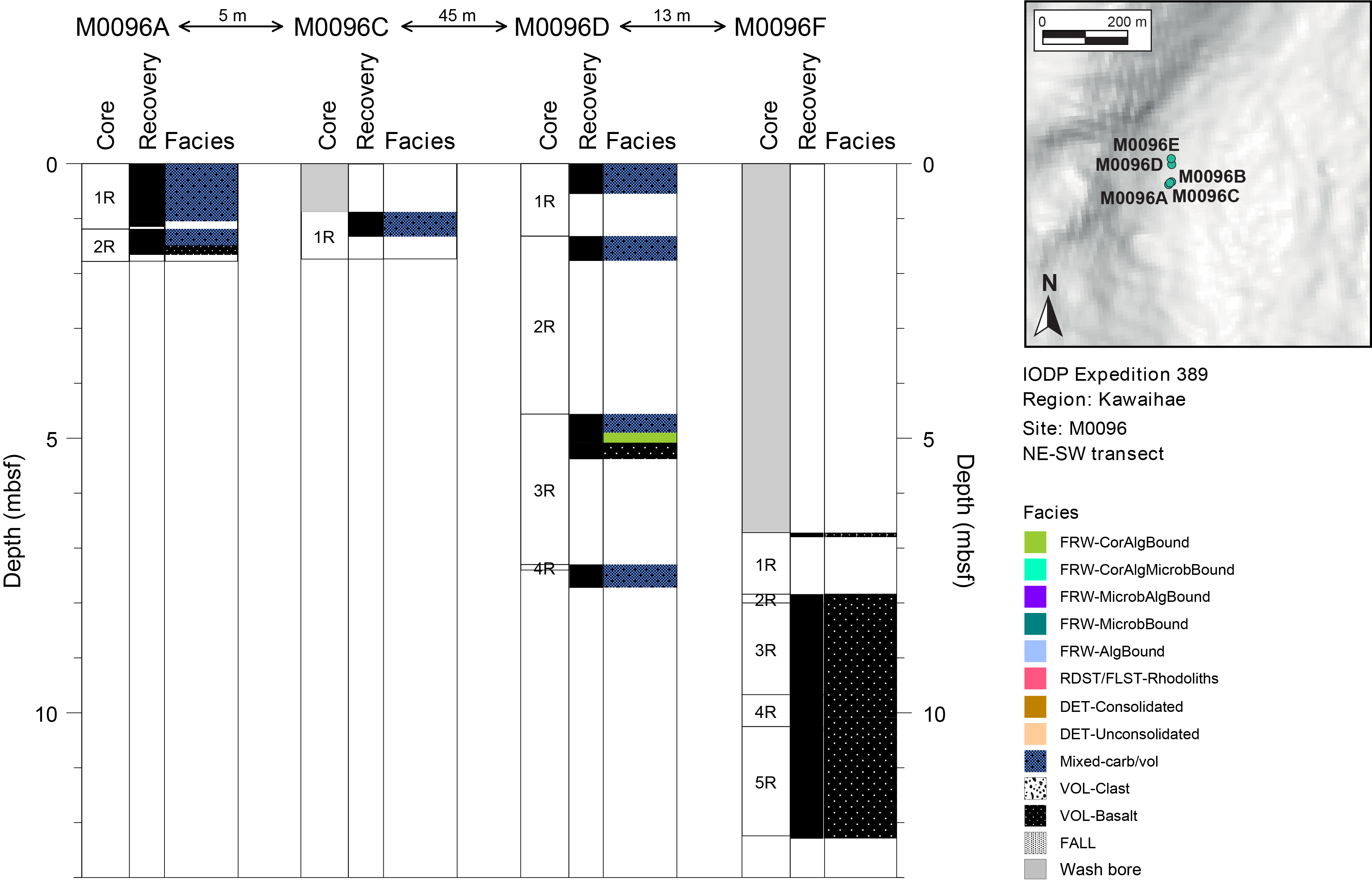
Figure F1. Lithostratigraphy.
2.1. Hole M0096A
In Hole M0096A, mixed carbonate-volcaniclastic sediment was recovered from 0.00 to 1.49 mbsf and lava was recovered from 1.49 to 1.66 mbsf (Figure F2). The carbonate-volcaniclastic sediment is a conglomerate of poorly rounded sand- to cobble-sized clasts of phaneritic and aphanitic lava, corals, crustose coralline algae (CCA), Halimeda plates, and other carbonate components. Most coral fragments are Porites branches, one massive Porites, and one Pocillopora branch. All volcanic clasts are rounded to subrounded. The porphyritic lava clasts have visible crystals of clinopyroxene and olivine in a phaneritic matrix, are generally dense (<5% vesicularity), and contain polygonal networks of secondary infilled cracks. The aphanitic lava clasts contain fewer phenocrysts (<5%) and contain two types of vesicles (several millimeters to 1 cm elongated and rounded to subrounded 1–5 mm vesicles). In most porphyritic lava clasts, a fine-grained, brown matrix makes up approximately 40% of the rock volume. The base of the hole (Section 2R-2) consists of two clasts of different lithologies (Figure F3). The first is an upper aphanitic basalt clast with rounded 2–5 mm vesicles, small olivine and clinopyroxene phenocrysts concentrated near the outer margins, and carbonate-filled cracks and a few rounded vesicles. The lower clast is a porphyritic picrite with approximately 50 vol% of subeuhedral to euhedral crystals, primarily of olivine, with lesser amounts of clinopyroxene. The lower clast also has a notable Fe oxide and clay-rich rind that is <1 mm thick.
Figure F2. Lithostratigraphy and MSCL data, Hole M0096A.
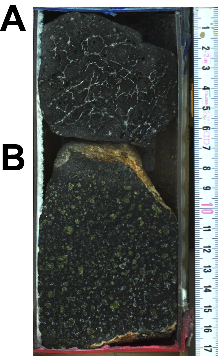
Figure F3. Lithologies, Hole M0096A.
2.2. Hole M0096B
This hole was cored by wash bore only; no core was recovered (Table T1).
2.3. Hole M0096C
In Hole M0096C, nothing was recovered from 0 to 0.88 mbsf. Granule- to pebble-sized fragments of lava rock, Halimeda grainstone, CCA, and corals (Porites and one Montipora) were recovered from 0.88 to 1.33 mbsf (Figure F4). There are multiple lava clasts with highly variable lithologies in the core. All lava clasts are subrounded to subangular and vary from dense, low-vesicularity, low-phenocryst varieties with visually fresh-appearing groundmass to significantly altered and with significant Fe oxide replacement products in the groundmass. Clasts near the bottom of the section are more vesicular and more crystal rich than those in the upper part of the section. A picrobasaltic lava clast at 1.19–1.23 mbsf (Figure F5) has variable features. The interior portion is a pristine looking lava rock with 10%–15% crystallinity and round vesicles. There is a sharp boundary to a highly altered (carbonate and Fe oxide replacement) exterior rind with similar crystallinity and vesicularity.
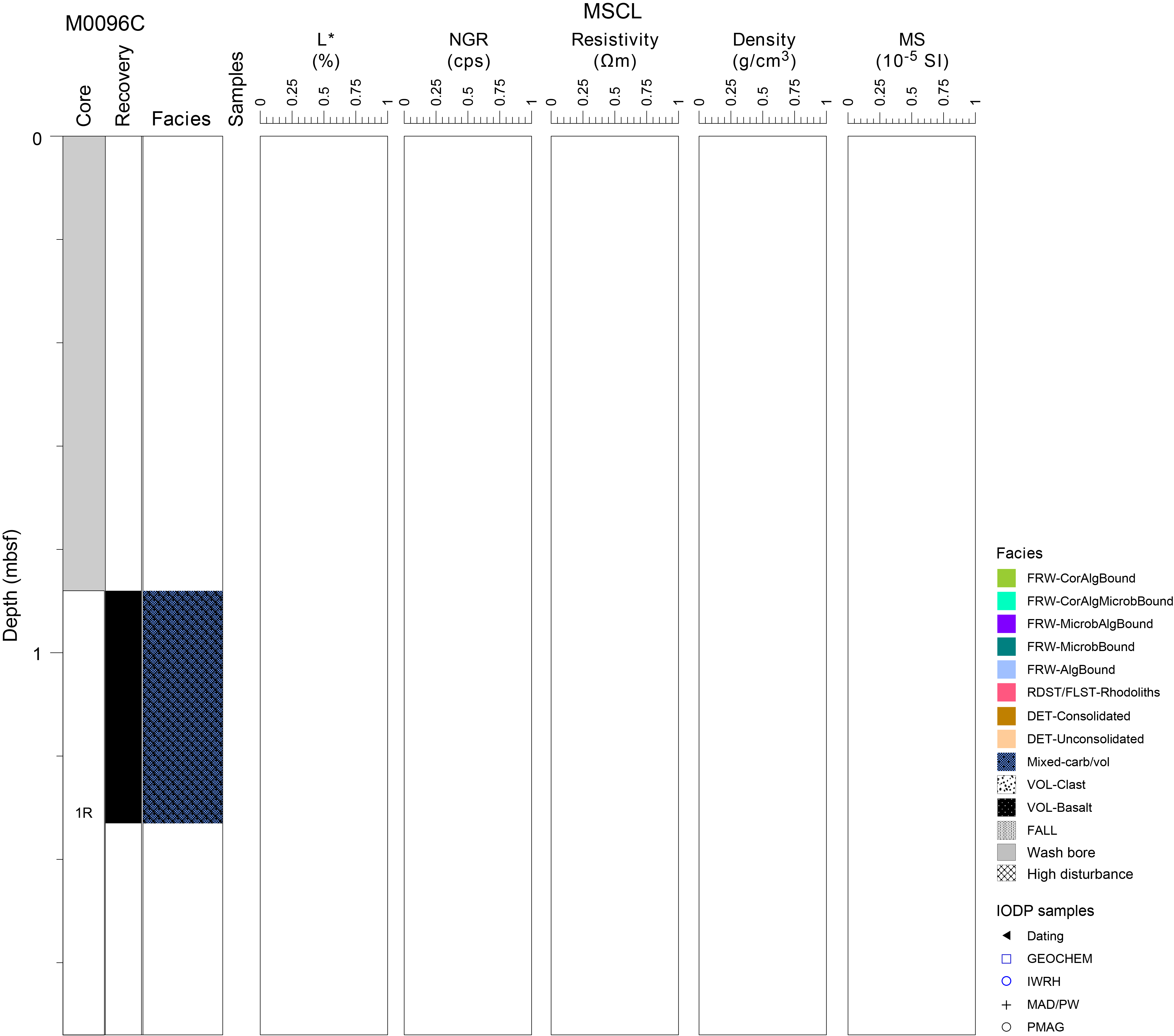
Figure F4. Lithostratigraphy and MSCL data, Hole M0096C.
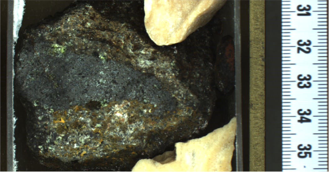
Figure F5. Picrobasalt lava clast.
2.4. Hole M0096D
In Hole M0096D, mixed carbonate-volcaniclastic sediment, coralgal boundstone, and lava were retrieved from 0 to 7.72 mbsf (Figure F6). The lava clasts in this core are highly variable in size, shape, composition, texture, and freshness, ranging from fresh, low-vesicularity picrobasalt lava with a high phenocryst content to highly altered lavas with and without phenocrysts. Most lava clasts contain round to subrounded vesicles. The uppermost 0.22 m is a conglomerate of granule- to pebble-sized lava fragments, coral (Porites), CCA, and Halimeda grainstone clasts in a coarse sandy matrix. Below this depth (Section 1R-1), the core is disturbed with fragments of the above facies. From 0.22 to 4.91 mbsf, clasts of aphanitic and phaneritic lava, CCA, corals (Porites and Pocillopora), and gastropod shells occur. A short interval (4.91–5.08 mbsf) of coralgal boundstone containing Porites and coralline algal crusts lies above an interval (5.08–5.38 mbsf) of aphanitic lava with olivine crystals and cracks. Section 3R-2 consists primarily of a contiguous volcanic unit from 5.15 to 5.38 mbsf that is either in-place lava rock or a very large, visually unoxidized clast with millimeter to submillimeter rounded vesicles, olivine microphenocrysts, and an inclined, calcite-infilled matrix crack zone. It is overlain by a thin layer (1–3 cm thick) consisting of highly vesicular, aphanitic, visibly altered rounded lava clasts with substantial infilling of vesicles, primarily by calcium carbonate precipitate and a variety of small detrital grains (Figure F7). The base of the core (7.30–7.72 mbsf) consists of mixed carbonate-volcaniclastic sediment with fragments of corals (Porites), CCA, and lava.
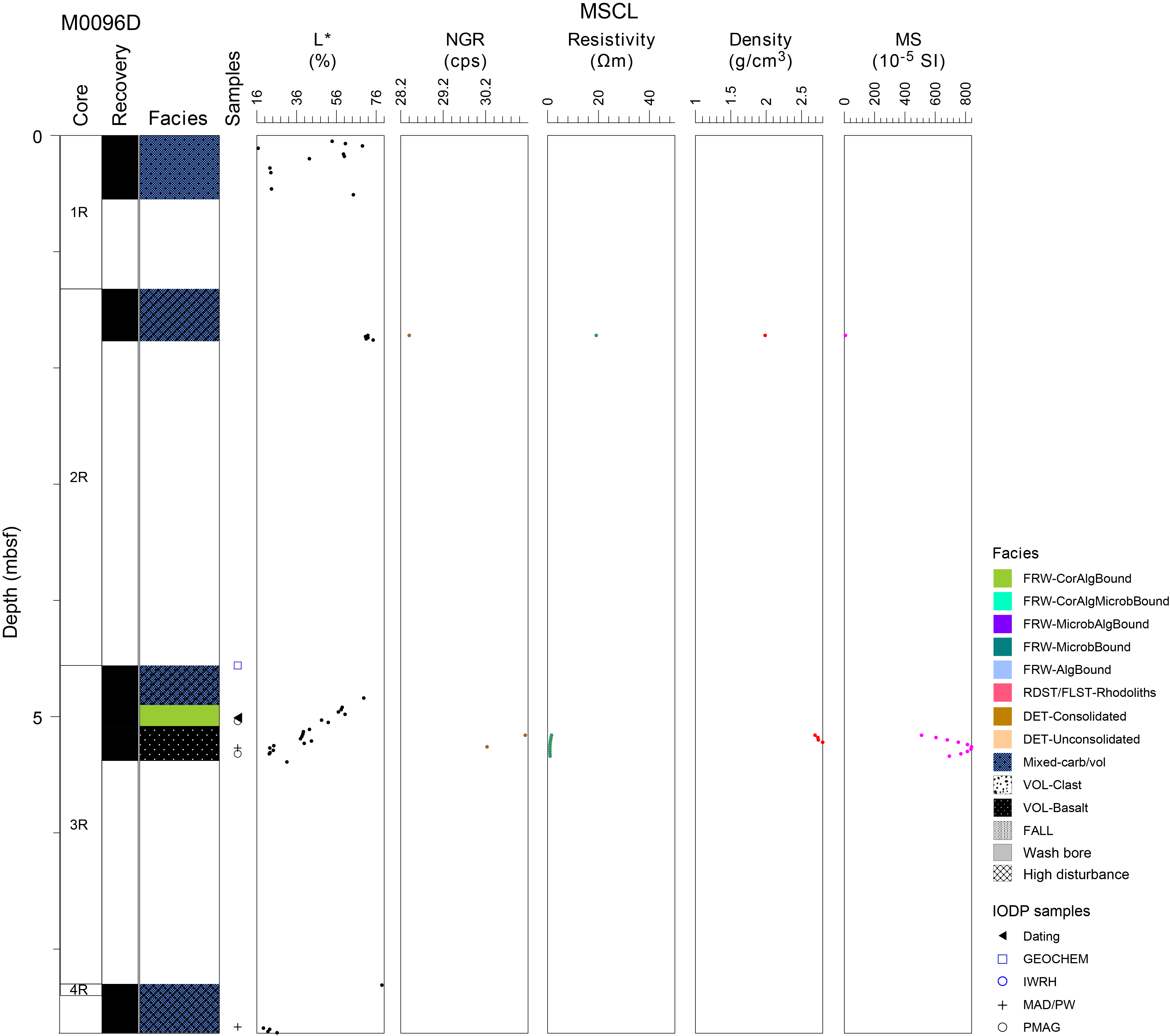
Figure F6. Lithostratigraphy and MSCL data, Hole M0096D.
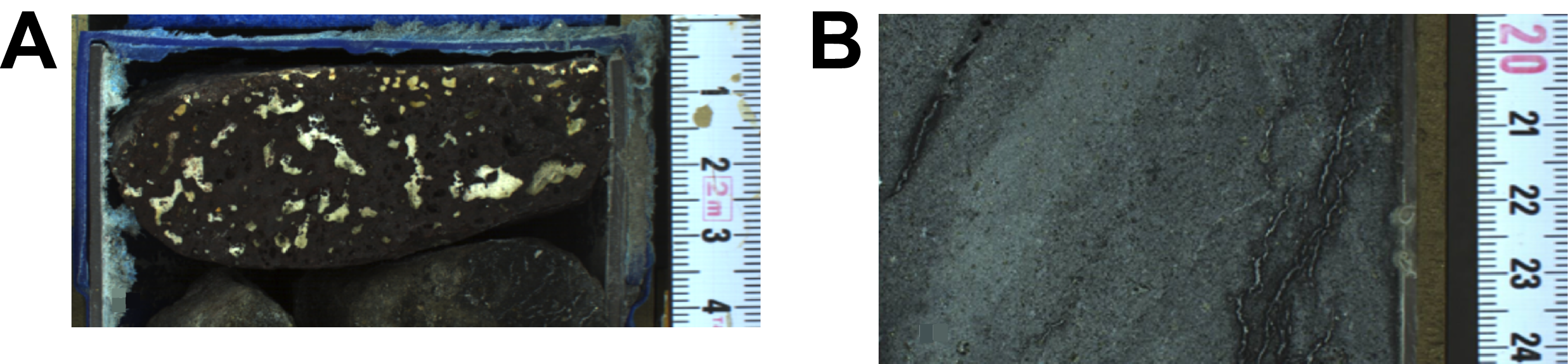
Figure F7. Lithologies, Hole M0096D.
2.5. Hole M0096E
This hole was cored by wash bore only; no core was recovered (Table T1).
2.6. Hole M0096F
Hole M0096F is substantially different than the others at this site (Figure F8). There is no recovery from 0 to 6.72 mbsf. The interval between 6.72 and 8.09 mbsf consists of a thin clastic layer (Sections 1R-1 and 2R-1) of a mixed lava assemblage of variable vesicularity, phenocryst abundance, phenocryst content (olivine ± pyroxene), rounding, and alteration. This mixed, clastic zone grades into an in-place ‘a‘a lava rock sequence in Section 3R-1. This in-place lava with flow texture is aphanitic and highly vesicular. Most of it is visually fresh with open but unornamented vesicle linings. There is a notable zone containing calcium carbonate–infilled vesicles and Fe oxide staining between 8.31 and 8.41 mbsf in this section (Figure F9A) and another interval at roughly 8.70 mbsf. The lava terminates abruptly at 9.00 mbsf (Figure F9B) into a 6 cm thick, highly altered zone with extensive bioclastic and siliciclastic deposition in vugs and voids of the lava rock, which overlies a highly variable rounded to subrounded autobreccia of aphanitic, vesicular lava of variable alteration. This altered zone lacks any calcite precipitates and has notable variation in matrix color (orange to black), indicating alteration under oxidizing conditions. This ‘a‘a clinker texture continues into Section 3R-2, although the extent of alteration increases with depth. The clinker texture continues through the top of Section 4R-1, back into fresh, vesicular ‘a‘a lava rock at 9.95 mbsf in the same section (Figure F9C). The rest of Section 4R-1 grades between coherent, aphanitic, generally phenocryst free, vesicular ‘a‘a lava rock and partially agglutinated subrounded clinker of variable freshness and vesicle infilling. Although texturally similar throughout Sections 3R-1 through 5R-2 (i.e., the contiguous bottom sections), the abrupt change in the macroscopic appearance of the lava rock and alteration at 9.00 mbsf indicates a substantial change in emplacement and alteration conditions, representing either a boundary between two discrete lava rock units with flow textures or a boundary within lobes of a compound lava flow rock unit that experienced sufficient time between lobe emplacement for a discrete alteration boundary to develop.
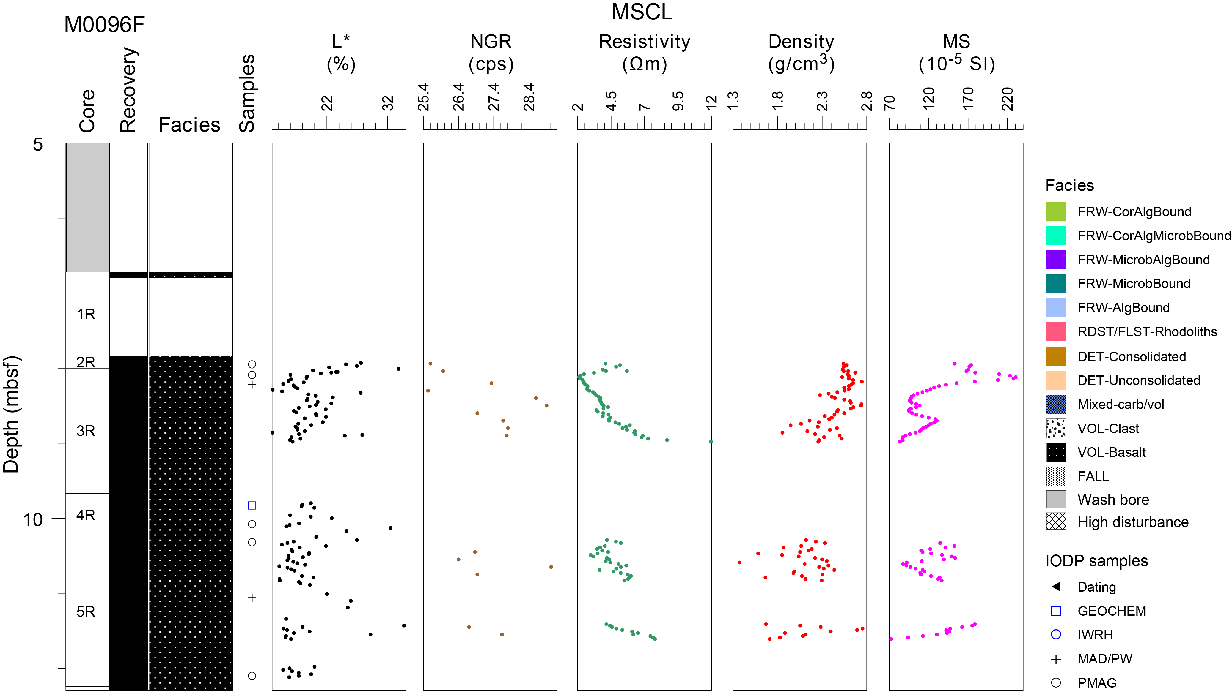
Figure F8. Lithostratigraphy and MSCL data, Hole M0096F.
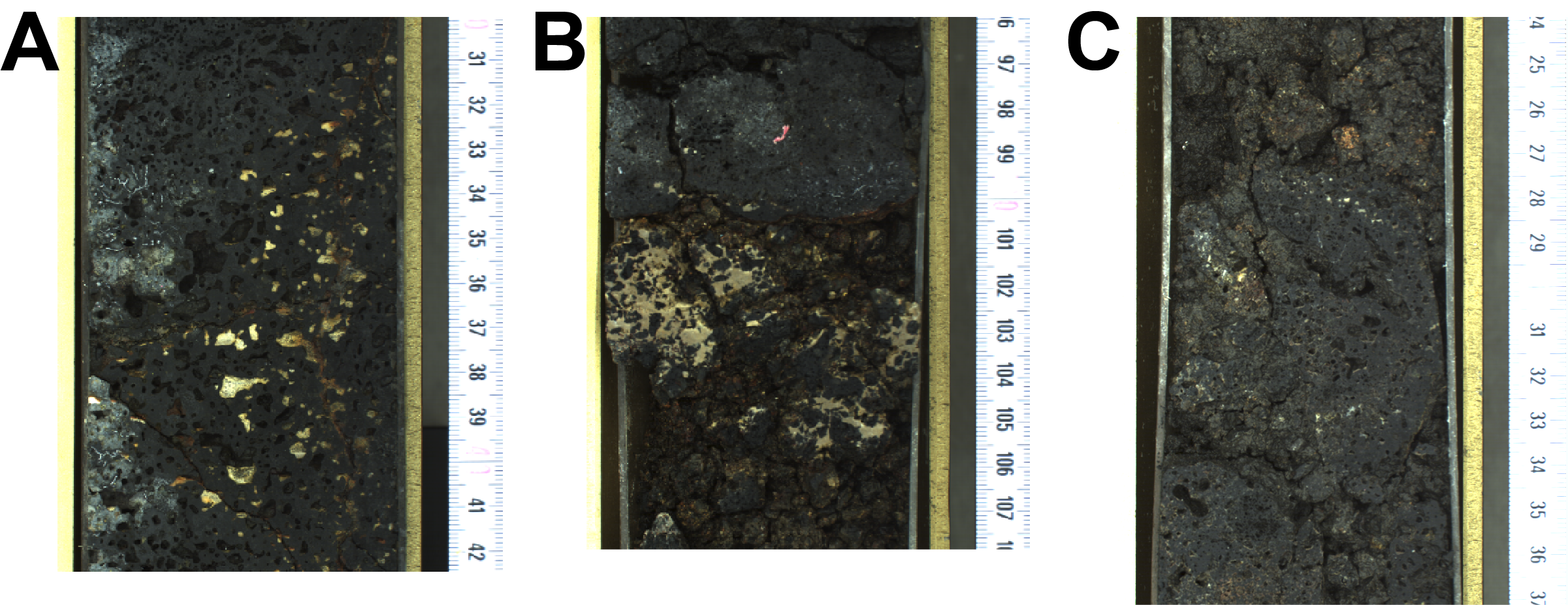
Figure F9. Lithologies, Hole M0096F.
X-ray fluorescence analysis of three lava samples from Site M0096 is broadly consistent with lava composition, variable degrees of alteration, and differences in primary phenocryst accumulation between specimens of the same primary magma deposit (see Geochemistry). There are insufficient data to constrain potential petrologic differences in source or fractionation history. X-ray diffraction (XRD) analysis of the same three samples indicates variable primary and secondary mineralogy. One sample (389-M0096F-04R-1, 16–17 cm; Figure F10) is moderately altered lava containing abundant calcium carbonate precipitates as vesicle infilling, whereas the lava contains abundant common primary igneous basaltic minerals. The lava also contains volumetrically minor quantities of a high-temperature silica polymorph, clay, and zeolite.

Figure F10. Altered lava rock fragment.
3. Physical properties
Physical properties data for Site M0096 are shown in Table T2.
3.1. Hole M0096A
A total of 1.52 m of core from Hole M0096A was scanned with the multisensor core logger (MSCL), and the core exhibited major drilling-induced disturbance, resulting in only 6% of the acquired data passing QA/QC (see Table T10 in the Expedition 398 methods chapter [Webster et al., 2025]). One discrete sample was taken for P-wave velocity and moisture and density (MAD) measurements. Digital linescans, color reflectance, and hyperspectral imaging were acquired on all cores.
3.1.1. Density and porosity
Density and porosity data are presented in Figures F2 and F11 and Table T2. MSCL bulk density values range 2.56–2.97 g/cm3. Drilling-induced disturbance and short core lengths compromised data quality (see Physical properties in the Expedition 389 methods chapter [Webster et al., 2025]) and limited sampling. However, one discrete sample was analyzed for MAD, giving a bulk density value of 2.88 g/cm3. The porosity value for this sample is 5.3%, and the grain density value is 2.986 g/cm3.
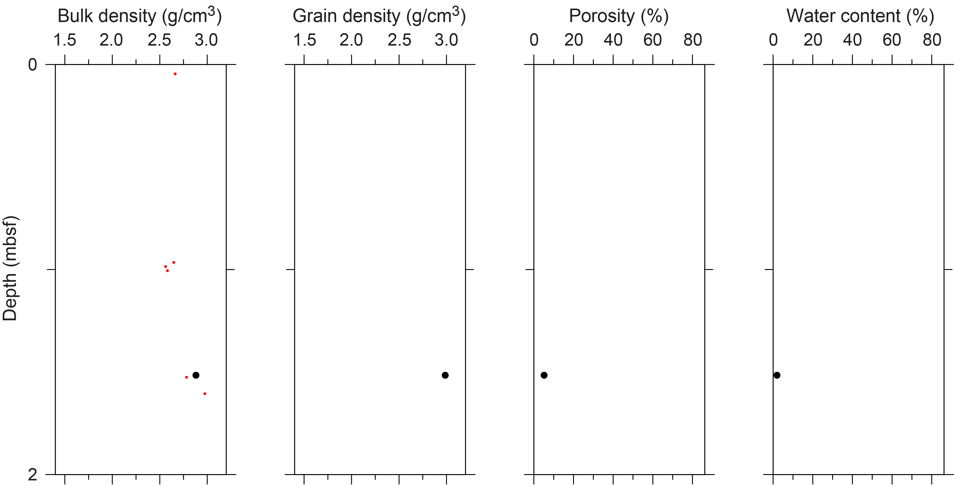
Figure F11. Physical properties, Hole M0096A.
3.1.2. P-wave velocity
P-wave velocity measurements on the MSCL yielded no data. One sample was measured using the discrete P-wave logger. The dry measurement value is 4758 m/s (Figure F12). P-wave velocity recorded for the same sample after resaturation is 6366 m/s. Because only one P-wave data point is available for Hole M0096A, there are no apparent downhole trends.
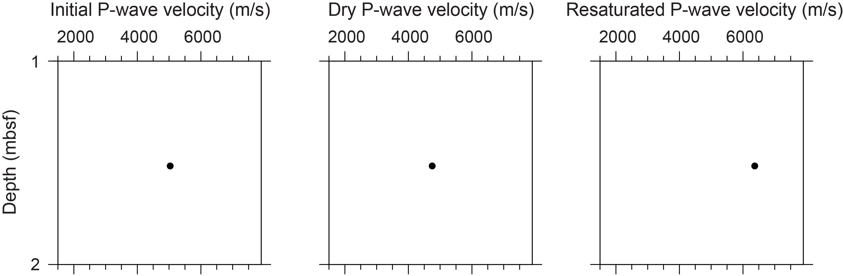
Figure F12. P-wave velocities, Hole M0096A.
3.1.3. Thermal conductivity
Because of the presence of drilling-induced disturbances, large voids, and uneven surfaces, thermal conductivity measurements were not performed on Hole M0096A cores.
3.1.4. Magnetic susceptibility
MSCL magnetic susceptibility data range 3.09 × 10⁻⁵ to 74.43 × 10⁻⁵ SI (Figure F2). Even though there are only five measurements available, the values reflect the lithology, with lower values in the upper mixed carbonate-volcaniclastic sediment and markedly higher values in the lava at the base.
3.1.5. Electrical resistivity
MSCL noncontact resistivity measurements range 4.02–10.63 Ωm (Figure F2). Similar to the other data sets for this hole, despite the limited data available, the change in lithology is reflected by higher values in the lava at the base of the hole.
3.1.6. Natural gamma radiation
MSCL natural gamma radiation (NGR) measurements range 26–32 counts/s and because of limited data points show no apparent downhole trends (Figure F2).
3.1.7. Digital linescans, color reflectance, and hyperspectral imaging
Cores were digitally scanned, measured for color reflectance (where appropriate), and imaged with the hyperspectral scanner (see HYPERSPECTRAL in Supplementary material). Color reflectance L* values vary between 10.71% and 74.19%, a* varies between −1.26 and 4.50, b* varies between −0.86 and 21.57, and a*/b* varies between −0.38 and 1.54, with high variability in the mixed carbonate-siliciclastic sediment and consistently low values in the lava unit. (Figure F2).
3.2. Hole M0096B
This hole was cored by wash bore only; no core was recovered (Table T1).
3.3. Hole M0096C
Hole M0096C was not scanned with the MSCL, nor were any discrete samples taken. Only digital linescans of the working and archive halves were taken.
3.4. Hole M0096D
A total of 2.24 m of core from Hole M0096D was scanned with the MSCL, and the core exhibited major drilling-induced disturbance, resulting in 12% of the acquired data passing QA/QC (see Table T10 in the Expedition 398 methods chapter [Webster et al., 2025]). Two discrete samples were taken for P-wave velocity and MAD measurements. Digital linescans, color reflectance, and hyperspectral imaging were acquired on all cores.
3.4.1. Density and porosity
Density and porosity data are presented in Figures F6 and F13 and Table T2. A single MSCL bulk density measurement of 1.99 g/cm3 was recorded. Drilling-induced disturbances and short core lengths compromised the quality of the remaining density data (see Physical properties in the Expedition 389 methods chapter [Webster et al., 2025]) and limited sampling. However, two discrete samples were analyzed for MAD, giving bulk density values in the range of 2.65–2.75 g/cm3. Porosity values for the same samples range 8.8%–19.9%, and grain density values fluctuate between 2.913 and 3.058 g/cm3. There are no apparent downhole trends in the density and porosity data sets and no clear relationship between the two bulk density measurements (MSCL and discrete).
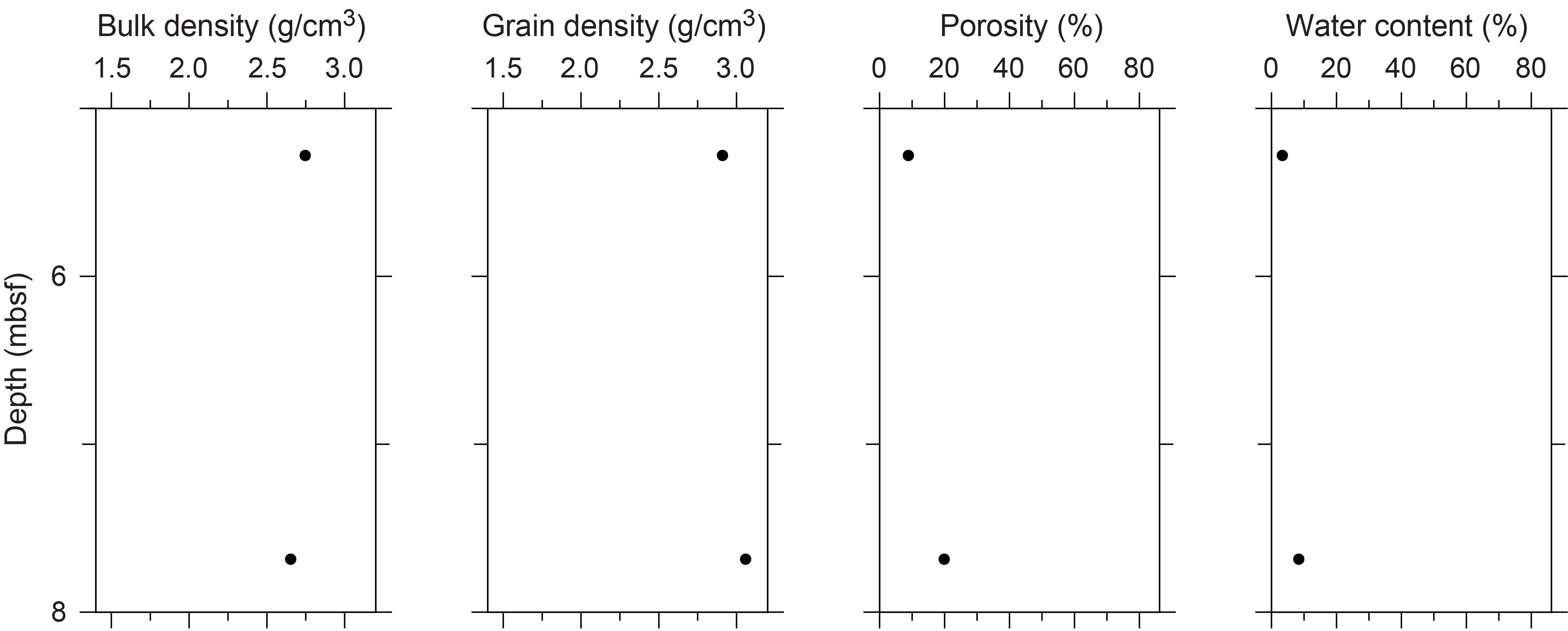
Figure F13. Physical properties, Hole M0096D.
3.4.2. P-wave velocity
MSCL P-wave velocity measurements yielded no data. Two samples were measured using the discrete P-wave logger. Dry measurement values are 2828 and 5228 m/s (Figure F14). P-wave velocities of 4123 and 7202 m/s were recorded for the resaturated samples. Because of the limited P-wave data points, it is not possible to detect downhole trends.
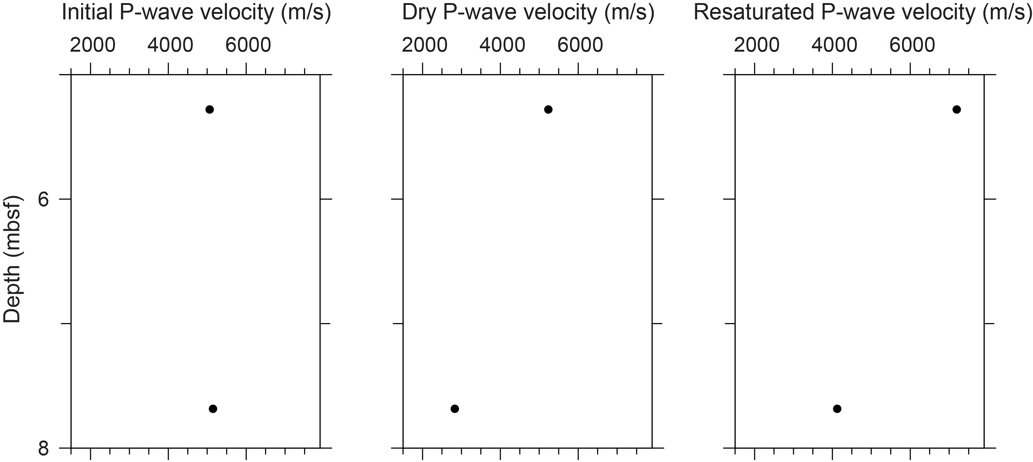
Figure F14. P-wave velocities, Hole M0096D.
3.4.3. Thermal conductivity
Thermal conductivity was collected on one core (see Table T11 in the Expedition 398 methods chapter [Webster et al., 2025]) and has a value of 1.793 W/(m·K).
3.4.4. Magnetic susceptibility
MSCL magnetic susceptibility data range 7.34 × 10⁻⁵ to 839.44 × 10⁻⁵ SI with mean values close to 665.00 × 10⁻⁵ SI (Figure F15).
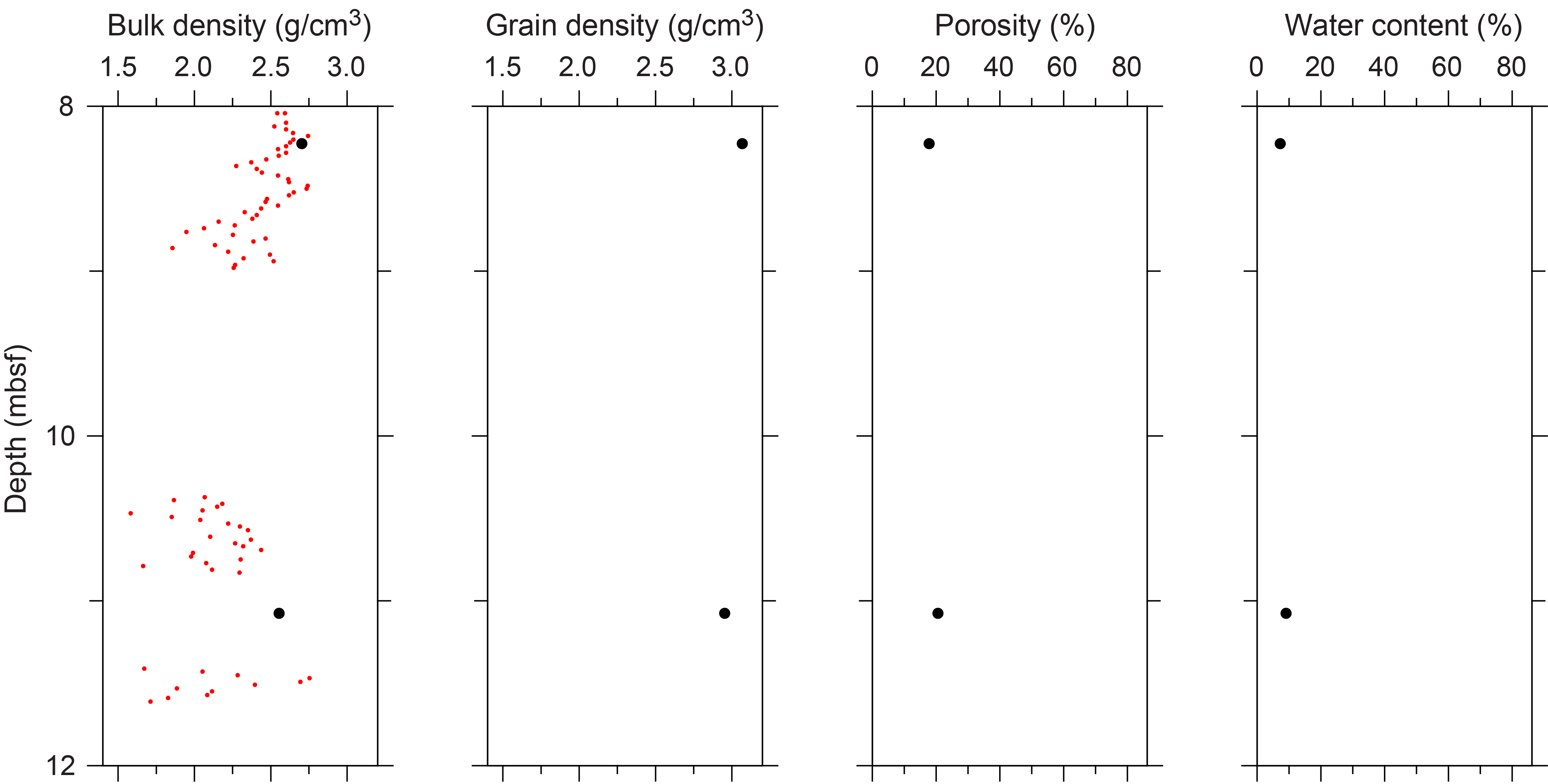
Figure F15. Physical properties, Hole M0096F.
3.4.5. Electrical resistivity
MSCL noncontact resistivity measurements yielded data ranging 0.90–19.13 Ωm (Figure F6). Similar to the other data sets for this hole, there are no apparent downhole trends.
3.4.6. Natural gamma radiation
MSCL NGR measurements display values ranging 28–31 counts/s and show no apparent downhole trends (Figure F6).
3.4.7. Digital linescans, color reflectance, and hyperspectral imaging
All cores were digitally scanned, and, where appropriate, measured for color reflectance and imaged with the hyperspectral scanner (see HYPERSPECTRAL in Supplementary material). Color reflectance L* values vary between 16.67% and 78.87%, a* varies between −1.31 and 3.82, b* varies between 0.60 and 20.16, and a*/b* varies between −2.08 and 0.25 (Figure F6).
3.5. Hole M0096E
This hole was cored by wash bore only; no core was recovered (Table T1).
3.6. Hole M0096F
A total of 4.48 m of core from Hole M0096F was scanned with the MSCL, and the core exhibited moderate drilling-induced disturbance, resulting in 44% of the acquired data passing QA/QC (see Table T10 in the Expedition 398 methods chapter [Webster et al., 2025]). Two discrete samples were taken for P-wave velocity and MAD measurements. Digital linescans, color reflectance, and hyperspectral imaging were acquired on all cores.
3.6.1. Density and porosity
Density and porosity data are presented in Figures F8 and F15 and Table T2. MSCL bulk density measurements range 1.37–2.75 g/cm3. Drilling-induced disturbances and short core lengths compromised the quality of the remaining density data (see Physical properties in the Expedition 389 methods chapter [Webster et al., 2025]) and limited sampling. Two discrete samples were analyzed for MAD, giving bulk density values in the range of 2.56–2.70 g/cm3. Porosity values for the same samples range 17.7%–20.6%, and grain density values fluctuate between 2.956 and 3.067 g/cm3. There are no clear downhole trends in the density and porosity data sets and no clear relationship between the two bulk density measurements (MSCL and discrete).
3.6.2. P-wave velocity
P-wave velocity MSCL measurements yielded no data. Two samples were measured using the discrete P-wave logger. Dry measurement values are 3622 and 3908 m/s (Figure F16). P-wave velocities of 4253 and 4742 m/s were measured for the resaturated samples. Because of the limited P-wave data points, there are no apparent downhole trends.
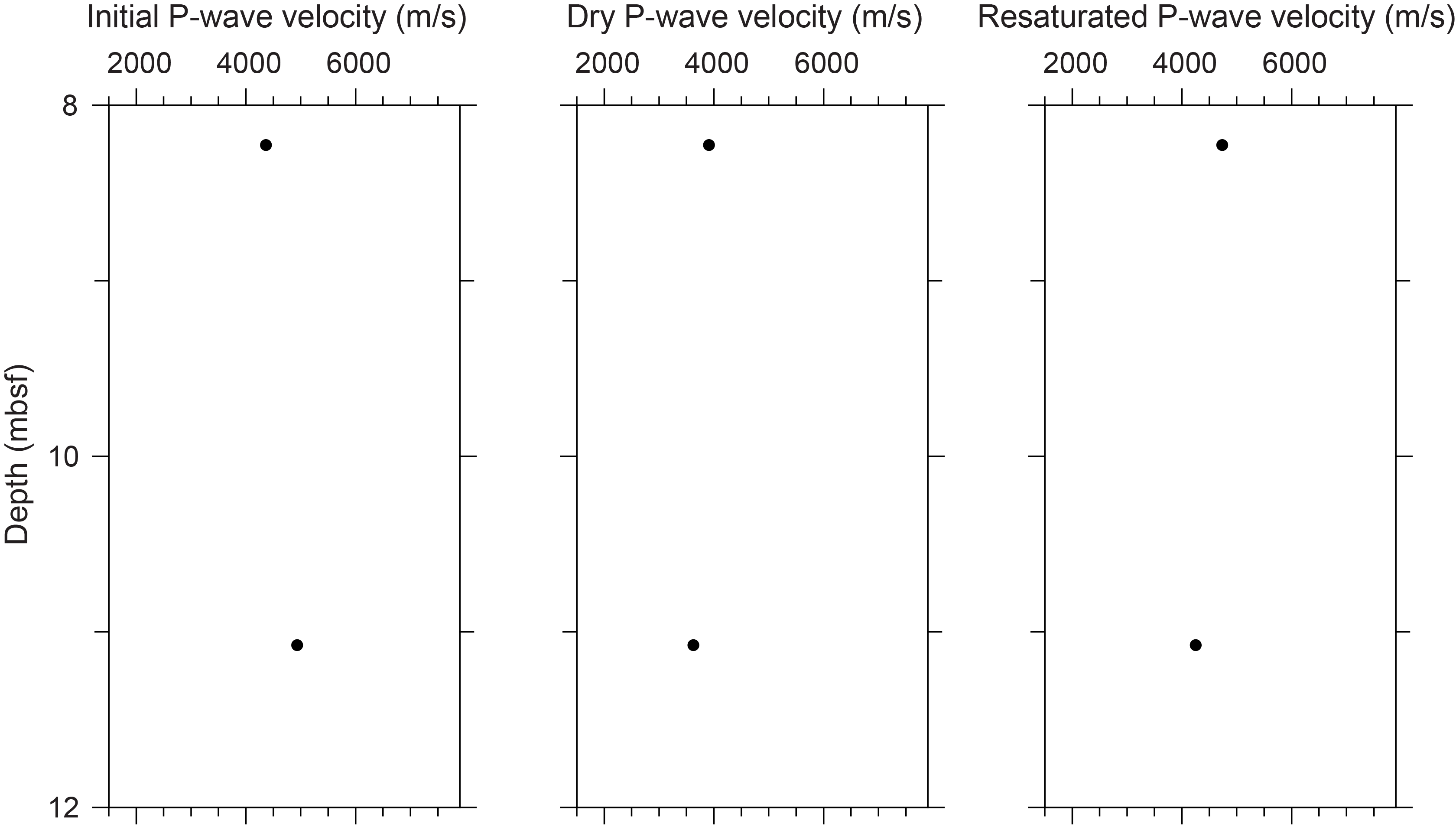
Figure F16. P-wave velocities, Hole M0096F.
3.6.3. Thermal conductivity
Thermal conductivity was collected on one core (see Table T11 in the Expedition 398 methods chapter [Webster et al., 2025]) and has a value of 1.533 W/(m·K).
3.6.4. Magnetic susceptibility
MSCL magnetic susceptibility data ranges 72.20 × 10⁻⁵ to 230.53 × 10⁻⁵ SI (Figure F8) with a mean value close to 127.00 × 10⁻⁵ SI, values consistent with the lava lithology of the hole.
3.6.5. Electrical resistivity
MSCL noncontact resistivity measurements range 2.11–11.97 Ωm (Figure F8). Like the other data sets for this hole, there are no apparent downhole trends, as expected for a hole with rather uniform lithology.
3.6.6. Natural gamma radiation
MSCL NGR measurements display values ranging 26–29 counts/s and show no apparent downhole trend (Figure F8).
3.6.7. Digital linescans, color reflectance, and hyperspectral imaging
All cores were digitally scanned, and, where appropriate, measured for color reflectance and imaged with the hyperspectral scanner (see HYPERSPECTRAL in Supplementary material). Color reflectance L* values vary between 13.05% and 34.68%, a* varies between −1.00 and 2.76, b* varies between −0.65 and 12.25, and a*/b* varies between −0.59 and 0.31 (Figure F8).
4. Geochemistry
4.1. Interstitial water
No interstitial water samples were collected from Site M0096.
4.2. Surface seawater
A surface seawater sample was collected from Site M0096 using an improvised sampling device from the side of the vessel (see Figure F22 in the Expedition 389 methods chapter [Webster et al., 2025]). The salinity, pH, alkalinity, ammonium, and major element chemistry measured for this sample are consistent with the other surface seawater samples taken during Expedition 389 and align with the expected values for conservative elements in seawater (see Tables T15 and T17 in the Expedition 389 methods chapter [Webster et al., 2025]).
4.3. Bulk sediment and rocks
A total of three lava samples were taken from Site M0096 (Figure F2) and analyzed for mineralogy, elemental composition, and carbon content. Sample 389-M0096F-4R-1, 16–17.5 cm (9.83 mbsf), was taken from a section of visually altered lava, whereas samples from Holes M0096A and M0096D were from smaller pieces of visually fresh lava.
4.4. Mineralogy
XRD analyses for Site M0096 are presented in Table T3. The mineralogy of Sample 389-M0096F-4R-1, 16–17.5 cm (9.83 mbsf), indicates moderately altered basalt, containing 48% secondary carbonate minerals (high-Mg calcite [29%] and mixed carbonates [19%]) and roughly 40% primary igneous minerals. The igneous components consist of a nearly equal abundance of high-Ca (anorthic) plagioclase feldspar (21%) and Mg-Ca (diopsan) clinopyroxene. Additionally, this specimen includes detectable clinoptilolite (zeolite; 4%) and cristobalite (5%), consistent with elevated temperatures during aqueous alteration. Visual inspection of the specimen indicates secondary carbonate is present as void infilling, rather than igneous mineral replacement (i.e., alteration). The specimen also contains volumetrically minor quantities of cristobalite (a high-temperature silica polymorph; 5%) and montmorillonite clay.
Sample 389-M0096A-1R-1, 24–27 cm (0.24 mbsf), consists of a mix of plagioclase (43%) and pyroxenes (22%) with some Mg-rich calcite (24%) and aragonite (7%) likely resulting from contamination from bioclasts. Lava rock Sample 389-M0096D-3R-1, 0–2 cm (4.56 mbsf), contains 99% pyroxene.
4.5. Elemental abundances
The concentrations of major elements in the lava rock samples from Site M0096 (Table T4) reflect the alteration and heterogeneity of the sample. Sample 389-M0096F-4R-1, 16–17.5 cm (9.83 mbsf), has higher Ca, Ti, and Zr, consistent with alteration products in the sample. This was also evident in the XRD data and visual inspection. Sample 389-M0096D-03R-1, 0-2 cm (4.56 mbsf), exhibits higher Mg, Cr, and Ni.
4.6. Carbon content
The results for total organic carbon (TOC), total carbon (TC), and total inorganic carbon (TIC) for the three samples measured at Site M0096 are presented in Table T5. The TOC content ranges 0.10%–0.16%, and the TIC content ranges 0.7%–3.0% (calculated to be 6%–25% CaCO 3 ; see GEOCHEM in Supplementary material). Sample 389-M0096F-4R-1, 16–17.5 cm (9.83 mbsf), has a slightly higher organic carbon content than the other volcanic samples from Site M0096.
5. Paleomagnetism
A total of eight plug samples were obtained from Holes M0096A, M0096D, and M0096F. Measurements of low-field and mass-specific magnetic susceptibility (χ) were carried out for all samples. The initial natural remanent magnetization (NRM) was measured for all samples, as was remanence following stepwise alternating field demagnetization up to maximum applied fields of 100 mT (Table T6). For further details, see Paleomagnetism in the Expedition 389 methods chapter (Webster et al., 2025).
5.1. Hole M0096A
One sample was taken from Hole M0096A (Sample 1R-1, 29–31 cm). It is primarily composed of lava. The low-field and mass-specific χ of the sample is 5.16 × 10⁻⁶ m3/kg. The initial NRM intensity is 1.28 A/m.
5.2. Hole M0096B
This hole was cored by wash bore only; no core was recovered (Table T1).
5.3. Hole M0096C
No samples for paleomagnetic analyses were taken from Hole M0096C.
5.4. Hole M0096D
Two samples were obtained from Hole M0096D. One is composed of carbonate (Sample 3R-1, 48–50 cm) and the other lava (Sample 3R-2, 23.5–26.5 cm). The carbonate sample shows a negative χ value of −1.66 × 10⁻⁹ m3/kg and a low initial NRM intensity of 4.50 × 10⁻³ A/m. In contrast, the lava sample shows a strong positive χ value of 4.28 × 10⁻⁵ m3/kg and a high initial NRM intensity of 1.94 × 101 A/m.
5.5. Hole M0096E
This hole was cored by wash bore only; no core was recovered (Table T1).
5.6. Hole M0096F
Five lava samples were collected from Hole M0096F. High positive χ values are observed throughout the hole, ranging 1.75 × 10⁻⁶ to 10.4 × 10⁻⁶ m3/kg. The initial NRM intensities decrease from 5.72 A/m at the bottom of the hole to 3.30 A/m at the top (Figure F17).
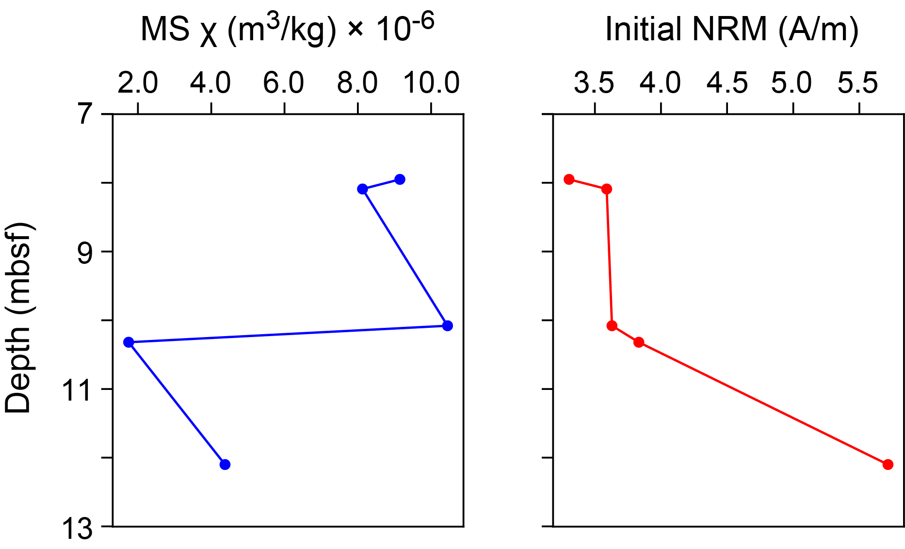
Figure F17. MS and NRM, Hole M0096F.
6. Geochronology
One U-Th date was obtained from a coral near the top of Hole M0096D (Sample 3R-1, 45–47 cm); it was not rejected (see Tables T21 and T22 in the Expedition 389 methods chapter [Webster et al., 2025]). The date is consistent with the interpretation of the age of this H4 terrace from previous studies (Ludwig et al., 1991; Webster et al., 2009).
References
Ludwig, K.R., Szabo, B.J., Moore, J.G., and Simmons, K.R., 1991. Crustal subsidence rate off Hawaii determined from 234U/238U ages of drowned coral reefs. Geology, 19(2):171–174.
https://doi.org/10.1130/0091-7613(1991)019<0171:CSROHD>2.3.CO;2
Webster, J.M., Braga, J.C., Clague, D.A., Gallup, C., Hein, J.R., Potts, D.C., Renema, W., Riding, R., Riker-Coleman, K., Silver, E., and Wallace, L.M., 2009. Coral reef evolution on rapidly subsiding margins. Global and Planetary Change, 66(1–2):129–148. https://doi.org/10.1016/j.gloplacha.2008.07.010
Webster, J.M., Ravelo, A.C., Grant, H.L.J., and the Expedition 389 Scientists, 2025. Supplementary material, https://doi.org/10.14379/iodp.proc.389supp.2025. In Webster, J.M., Ravelo, A.C., Grant, H.L.J., and the Expedition 389 Scientists, Hawaiian Drowned Reefs. Proceedings of the International Ocean Discovery Program, 389: College Station, TX (International Ocean Discovery Program).
Webster, J.M., Ravelo, A.C., Grant, H.L.J., Rydzy, M., Stewart, M., Allison, N., Asami, R., Boston, B., Braga, J.C., Brenner, L., Chen, X., Chutcharavan, P., Dutton, A., Felis, T., Fukuyo, N., Gischler, E., Greve, S., Hagen, A., Hamon, Y., Hathorne, E., Humblet, M., Jorry, S., Khanna, P., Le Ber, E., McGregor, H., Mortlock, R., Nohl, T., Potts, D., Prohaska, A., Prouty, N., Renema, W., Rubin, K.H., Westphal, H., and Yokoyama, Y., 2025. Expedition 389 methods. In Webster, J.M., Ravelo, A.C., Grant, H.L.J., and the Expedition 389 Scientists, Hawaiian Drowned Reefs. Proceedings of the International Ocean Discovery Program, 389: College Station, TX (International Ocean Discovery Program). https://doi.org/10.14379/iodp.proc.389.102.2025