| IODP Proceedings Volume contents Search | |||||||||||||||||||||||||||||||||||||
 | |||||||||||||||||||||||||||||||||||||
| Expedition reports Research results Supplementary material Drilling maps Expedition bibliography | |||||||||||||||||||||||||||||||||||||
|
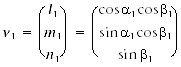
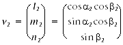
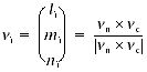
doi:10.2204/iodp.proc.314315316.132.2009 Structural geologyOur methods for documenting the structural geology of Expedition 316 cores largely followed those given by the Expedition 315 structural geologists (see “Structural geology” in the “Expedition 315 methods” chapter). We documented the deformation observed in the split cores by classifying structures, determining the depth extent, measuring orientation data, and recording kinematic information. The collected data were hand logged onto a printed form at the core table and then typed into both a spreadsheet and the J-CORES database. Where possible, the orientation data were also corrected for rotations related to drilling on the basis of paleomagnetic declination and inclination information. Core description and orientation data collectionEach structure was recorded manually on a structural description sheet modified from that used during Expedition 315 (Fig. F14). We found that this modified sheet is particularly useful to record orientation data for linear structures (e.g., striation on the fault plane). Core measurements followed Expedition 315, which in turn were based on previous ODP procedures developed at the Nankai accretionary margin (i.e., ODP Legs 131 and 190). We used a plastic protractor for orientation measurements (Fig. F15). During Expedition 316, we downloaded the X-ray CT images of unsplit cores from the database on the Chikyu to identify structures and recognize 3-D geometry and distribution of structures. Using the working half of the split core provided greater flexibility in removing—and cutting, if necessary—pieces of the core for more careful study and measurement. Orientations of planar and linear features in cored sediments were determined relative to the core axis, which represents vertical in the core reference frame, and the “double line” marked on the working half of the split core liner, which represents north (or 0° and 360°) in the core reference frame (Fig. F16). To determine the orientation of a plane, two apparent dips of the planar feature were measured in the core reference frame and converted to a plane represented by either a strike and dip or a dip and dip direction. This conversion was accomplished using a spreadsheet (Fig. F17). This approach had the advantage of increasing the data processing efficiency and reducing errors in transferring and retyping data (e.g., by using both R. Allmendinger’s Stereonet program [www.geo.cornell.edu/geology/faculty/RWA/programs.html] and a spreadsheet). One apparent dip was typically represented by the intersection of the planar feature with the split face of the core and was quantified by measuring the dip direction and angle in the core reference frame. Typical apparent dip measurements had a trend of 090° or 270° and ranged in plunge from 0° to 90°. The second apparent dip was usually represented by the intersection of the planar feature and a cut or fractured surface at a high angle to the split face of the core axis. In many cases, this was a surface either parallel or perpendicular to the core axis. In the former cases, the apparent dip lineation would trend 000° or 180° and plunge from 0° to 90°; in the latter cases, the trend would range from 000° to 360° and plunge 0°. Linear features observed in the cores were always associated with planar structures (typically faults or shear zones), and their orientations were determined by measuring either the trend and plunge in the core reference frame or the rake (or pitch) on the associated plane. All data were recorded on the log sheet with appropriate depths and descriptive information. Paleomagnetic data were routinely used to correct drilling-induced rotations of cored sediments. Rotations were induced during RCB and ESCS coring, as is common in ocean drilling. In cases where core sections were not continuous (generally this included core sections <10 cm long), individual samples were placed in a core liner at 20 cm intervals, which is the sampling length of the long-core cyrogenic magnetometer on the Chikyu. Orientation data analysis based on the spreadsheetDuring Expedition 316, we adopted the Expedition 315 spreadsheet template for orientation data calculation in the core reference frame, as well as in the geographic reference frame from those data measured on cores (e.g., Fig. F17). The core reference frame is such that the upcore direction is vertical upward, the core-splitting plane is east–west vertical, and the double-lined side of the working half points toward north (Fig. F16). Calculation of plane orientationFor planar structures (e.g., bedding or faults), two apparent dips on two different surfaces (e.g., one being the split core surface, which is east–west vertical, and the other being the horizontal or north–south vertical surface) were measured in the core reference frame as azimuths (measured clockwise from north, looking down) and plunges (Fig. F18). A coordinate system was defined in such a way that the positive x-, y-, and z-directions coincide with north, east, and vertical downward, respectively (Fig. F16). If the azimuths and plunges of the two apparent dips are given as (α1, β1) and (α2, β2), respectively, as in Figure F18, then the unit vectors representing these two lines, v1 and v2, are
and
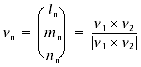
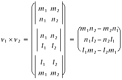
The unit vector normal to this plane, vn (Fig. F18), is then defined as follows:
where
The azimuth, αn, and plunge, βn, of vn are given by
The dip direction, αd, and dip angle, β, of this plane are αn and 90° + βn, respectively, when βn is <0° (Fig. F19A). They are αn ± 180° and 90° – βn, respectively, when βn is ≥0° (Fig. F19B). The right-hand rule strike of this plane, αs, is then given by αd – 90° (Fig. F19). Calculation of slickenline rakeFor a fault with slickenlines, the apparent rake angle of the slickenline, ϕa, was measured on the fault surface from either the 090° or 270° direction of the split-core surface trace (Fig. F20). Fault orientation was measured as described above. Provided that vn and vc are unit vectors normal to the fault and split core surfaces, respectively, the unit vector of this intersection line, vi, is perpendicular to both vn and vc (Fig. F20) and is therefore defined as follows:
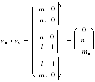
where
and
Knowing the right-hand rule strike of the fault plane, αs, the unit vector, vs, toward this direction is then
The rake angle of the intersection line, ϕi, measured from the strike direction is given by
because
The rake angle of the slickenline, ϕ, from the strike direction is ϕi ± ϕa, depending on which direction the apparent rake was measured from and which direction the fault plane dips toward. ϕa should be subtracted from ϕi when the fault plane dips toward west and ϕa was measured from either the top or 090° direction (Fig. F21A) or when the fault plane dips toward east and ϕa was measured from either the bottom or 090° direction (Fig. F21B). On the other hand, ϕa should be added to ϕi when the fault plane dips toward east and ϕa was measured from either the top or 270° direction (Fig. F21C) or when the fault plane dips toward west and ϕa was measured from either the bottom or 270° direction (Fig. F21D). Azimuth correction using paleomagnetic dataProvided that a core is vertical, its magnetization is primary, and its bedding is horizontal, its paleomagnetic declination, αp, indicates magnetic north when its inclination, βp, is ≥0° (Fig. F22A), whereas it indicates magnetic south when βp is <0° (Fig. F22B). The dip direction and strike of a plane in the geographic reference frame, αd* and αs*, are therefore
and
when
and are
and
when
J-CORES structural databaseStructural data entered in the J-CORES database VCD program include a visual (macroscopic and/or microscopic) description of core structures at a given section index and a record of planar structures in the core reference frame. Tablet PCs equipped with a wireless interface and writing recognition software were provided to allow data input directly from the core description tables. As pointed out by Expedition 315 structural geologists, however, we found it more efficient to record the data on paper logs first and then transfer the data into the J-CORES database at a later time. Data were also entered into a spreadsheet (Fig. F17) for postacquisition processing. Data entry through the VCD program proceeds as follows:
After saving, data are automatically uploaded to the Chikyu server and can be retrieved afterward as text or as an Excel file for processing. It is important to note that scientists are only allowed to write data in their own field of research and for their expedition (e.g., an Expedition 316 structural geologist can input only structural data for Expedition 316). Any logged-in user has “read” access to the entire database. Description and classification of structuresFrom a lithological point of view, the cores recovered during Expedition 316 predominantly consist of unconsolidated to slightly consolidated material. Thus the lithology description does not use the suffix “stone.” However, from a structural geology point of view, the deformation style of most of the materials retrieved from depths larger than ~100 m (by ESCS or RCB methods) is clearly brittle without any soft deformation structures. Such a mechanical response prompts us to add the suffix “stone” to lithologic substantives, at least for cores retrieved from below slope sediments. In general, we described and classified the structures observed using the terminology of J-CORES and Expedition 315, which in turn is based on the J-DESC VCD scheme and ODP Legs 131 (Taira, Hill, Firth, et al., 1991), 156 (Shipley, Ogawa, Blum, et al., 1995), 170 (Kimura, Silver, Blum, et al., 1997), and 190 (Moore, Taira, Klaus, et al., 2001). For clarity, however, we define the terminology used to describe fault-related rocks, as well as the basis for differentiating natural and drilling-induced features. The key to the symbols used in J-CORES is given in Figure F24. Tectonic breccias and gougesTectonic breccias and gouges include four types of deformed rocks: protobreccias, breccias, microbreccias, and gouges. Protobreccias consist of angular to subangular fragments of centimeter size with little or no matrix in between. Fragment surfaces are commonly polished or striated. On CT images, the original structure of the rock can still be recognized. In particular, there is no evidence for fragment rotation. Protobreccias are transitional between fractured rocks and true breccias. Breccias are composed of fragments with a mean length of ~5 mm. The presence of a matrix is difficult to ascertain when pervasive intrusion of drilling mud occurred. The fragments have striated surfaces and may exhibit an incipient spaced cleavage. Microbreccias consist of fine fragments (less than ~1 mm long) embedded in a light green to light gray clayey matrix. With increasing clay content and decreasing size of fragments, microbreccia can transition to fault gouge, which consists of a very fine grained and commonly clayey product inside which fragments are not macroscopically recognizable. The recognition of tectonic breccias and gouges in cores is of primary importance because it constitutes a straightforward way to locate fault zones and, more precisely, principal slip zones (so-called fault cores) where displacement is supposed to be maximum. This recognition, easily done in the field on land, appears to be less trivial in cores, mainly because of frequent drilling-induced or splitting-induced brecciation and/or drilling mud injection; both processes tend to produce structures that mimic natural products. During Expedition 316, the distinction between tectonic breccias and induced breccias was based on a set of criteria that includes
The distinction between tectonic gouge and drilling-induced mud is delicate:
Minor faultsIt may be difficult to distinguish natural faults from drilling-induced faults. Helicoidal striated surfaces or polished surfaces showing striations that diverge outward most likely indicate drilling-induced fracturing resulting from the torque exerted by the bit on sediments. In contrast, faults that display more planar geometries, parallel lineations, and orientations compatible with preferred orientations displayed by multiple faults nearby are likely natural features. Lastly, when multiple orientation measurements are plotted in stereographic projection, natural minor faults are expected to display preferred orientations that may define coherent strain axes, whereas drilling-induced faults are expected to yield random orientation distributions. |
|||||||||||||||||||||||||||||||||||||

 .
. ,
, .
. ,
,
 .
. .
.