Druitt, T.H., Kutterolf, S., Ronge, T.A., and the Expedition 398 Scientists
Proceedings of the International Ocean Discovery Program Volume 398
publications.iodp.org
https://doi.org/10.14379/iodp.proc.398.201.2025
Data report: core-seismic integration and time-depth relationships at IODP Expedition 398 Hellenic Arc Volcanic Field sites1
Jonas Preine,2 Gareth Crutchley,3 Christian Hübscher,2 Michael Manga,2 Masako Tominaga,2 Sarah Beethe,2 Iona McIntosh,2 Paraskevi Nomikou,2 Günther Kletetschka,2 Tim Druitt,2 Steffen Kutterolf,2 Thomas Ronge,2 Alexis Bernard,2 Carole Berthod,2 Hehe Chen,2 Shun Chiyonobu,2 Acacia Clark,2 Susan DeBari,2 Tatiana I. Fernandez-Perez,2 Ralf Gertisser,2 Raymond M. Johnston,2 Christopher Jones,2 K. Batuk Joshi,2 Olga Koukousioura,2 Xiaohui Li,2 Molly McCanta,2 Antony Morris,2 Katharina Pank,2 Ally Peccia,2 Paraskevi N. Polymenakou,2 Adam Woodhouse,2 Yuzuru Yamamoto,2 Jens Karstens,3 and Zenon Mateo4
1 Preine, J., Crutchley, G., Hübscher, C., Manga, M., Tominaga, M., Beethe, S., McIntosh, I., Nomikou, P., Kletetschka, G., Druitt, T., Kutterolf, S., Ronge, T., Bernard, A., Berthod, C., Chen, H., Chiyonobu, S., Clark, A., DeBari, S., Fernandez-Perez, T.I., Gertisser, R., Johnston, R.M., Jones, C., Joshi, K.B., Koukousioura, O., Li, X., McCanta, M., Morris, A., Pank, K., Peccia, A., Polymenakou, P.N., Woodhouse, A., Yamamoto, Y., Karstens, J., and Mateo, Z., 2025. Data report: core-seismic integration and time-depth relationships at IODP Expedition 398 Hellenic Arc Volcanic Field sites. In Druitt, T.H., Kutterolf, S., Ronge, T.A., and the Expedition 398 Scientists, Hellenic Arc Volcanic Field. Proceedings of the International Ocean Discovery Program, 398: College Station, TX (International Ocean Discovery Program). https://doi.org/10.14379/iodp.proc.398.201.2025
2 Expedition 398 Scientists' affiliations. Correspondence author: jonas.preine@uni-hamburg.de
3 GEOMAR Helmholtz Centre for Ocean Research Kiel, Germany.
4 International Ocean Discovery Program, Texas A&M University, USA.
Abstract
We present seismic two-way traveltime depth relationships for all sites drilled by the International Ocean Discovery Program Expedition 398, Hellenic Arc Volcanic Field, using high-resolution multichannel seismic and core data. First, we filter and interpolate P-wave velocity and density data taken from (1) whole-round cores and (2) discrete measurements on half-round cores. We establish the reliability of shipboard density measurements by comparing them with in situ logging data. Using these validated measurements, we estimate acoustic impedance and synthetic seismograms. By correlating synthetic seismograms with those extracted from multichannel seismic profiles at each site, we establish time-depth relationships. We assess the quality of these relationships by examining the alignment of major lithologic boundaries with prominent unconformities or correlated conformities in the reflection seismic data. The results of this report facilitate the mapping of core data onto the multichannel seismic profiles at each site, allowing for spatial tracing of core data across the Christiana-Santorini-Kolumbo volcanic field.
1. Introduction
International Ocean Discovery Program (IODP) Expedition 398, Hellenic Arc Volcanic Field (11 December 2022–10 February 2023), aimed to (1) explore the volcanic record of the South Aegean Volcanic Arc; (2) investigate the interplay between volcanism, upper-plate lithospheric tectonics, and sea level; (3) understand the processes and products of shallow submarine eruptions; and (4) analyze the sedimentary infill of the Santorini Caldera (Druitt et al., 2022). Achieving these objectives necessitates extending the constrained 1D stratigraphic model from the wells regionally across the rift basins and the caldera by correlating core data to reflection seismic data (Preine, 2022). This allows for mapping of the distribution and volume of individual volcanic units (e.g., Druitt et al., 2024h; Preine et al., 2024) and relating core data to the regional tectonic framework.
IODP Expedition 398 drilled 12 sites: 4 sites within the Santorini Caldera and 8 in the rift basins (Druitt et al., 2024a) (Figure F1). Challenging drilling conditions resulted in varying recovery and, due to hole instabilities, downhole logging operations were only conducted at Site U1589 (Druitt et al., 2024b). To ensure a consistent workflow for integrating core data with seismic reflection data at all sites, our approach focuses on the physical properties measured on the cores.
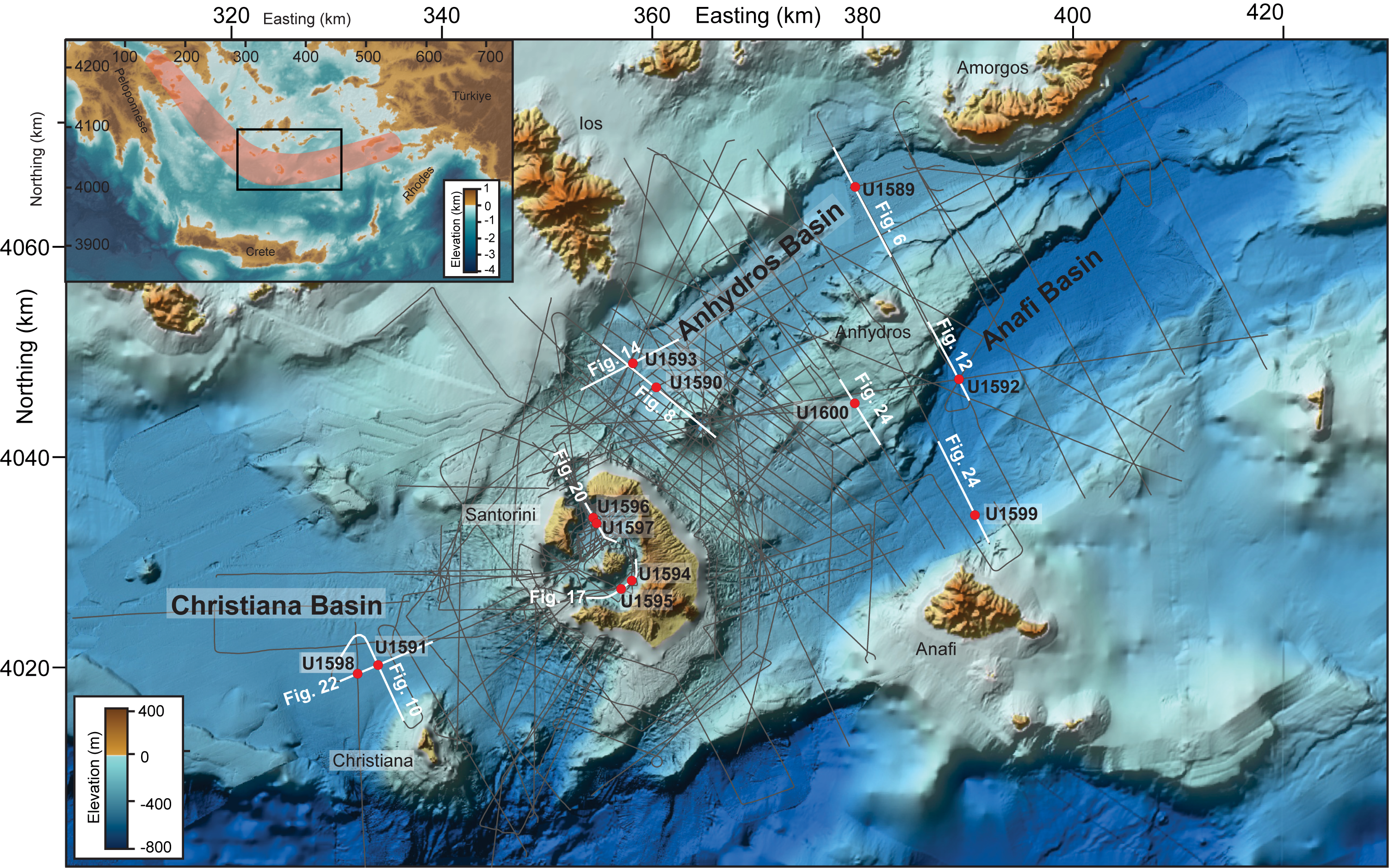
Figure F1. Christiana-Santorini-Kolumbo rift zone.
The objective of this report is to provide seismic two-way traveltime (TWT) depth relationships that allow linking information retrieved from the cores with the regional seismic data. Therefore, we first filter and interpolate shipboard measurements of density and P-wave velocity measured on whole-round and half-round cores. Using these measurements, we create synthetic seismograms, which we then correlate with the seismic data and establish time-depth charts for all sites of Expedition 398.
2. Methods and materials
2.1. Seismic reflection data
The seismic data relevant for this report were collected during two cruises on the research vessel (R/V) Poseidon 2006 (Cruise POS338) and 2019 (Cruise POS538) (Hübscher et al., 2006; Karstens et al., 2020). All seismic data processing was carried out using the VISTA software from Schlumberger (Preine, 2022).
For Cruise POS338, a generator-injector (GI)-pulser was used in true GI mode with a primary (generator) volume of 45 inches3 and a secondary (injector) volume of 105 inches3. A 600 m analog streamer was used with 24 channels and binned with a common midpoint (CMP) spacing of 12.5 m. Data processing included trace editing, simple frequency filtering (10–500 Hz), suppression of a receiver-ghost signal by predictive deconvolution, surface-related multiple elimination, spherical divergence correction, finite-difference time migration, top-muting, and white-noise removal. These data have a main frequency of 60 Hz, indicating a vertical resolution of approximately 8 m, assuming the λ/4 criterion and a representative velocity of 2000 m/s (Preine, 2022). Seismic profiles from this cruise are labeled "HH06-XX".
During Cruise POS538 in 2019, seismic data were acquired with very high lateral resolution (CMP spacing of ~1.56 m; Karstens et al., 2020). A GI-pulser operated in harmonic mode with primary and secondary volumes of 45 inches3 was used as the seismic source. Seismic energy was recorded by multiple concatenated Geometrics GeoEel streamer segments, resulting in active streamer sections ranging 190–250 m in length. Processing included trace editing, simple frequency filtering (15–1500 Hz), and multiple suppression using surface-related multiple elimination (SRME). This was followed by spherical divergence correction, time-variant frequency filtering, finite-difference time migration, top-muting, and white-noise removal. With a main frequency of 125 Hz, the vertical resolution can be approximated to 4 m, assuming the λ/4 criterion and a velocity of 2000 m/s (Preine, 2022). Seismic profiles from this cruise are labeled "GEOMAR_XXXX".
All data were homogenized by applying a mean scale and aligning them to a common relative datum, then integrated into a joint interpretation project (Preine, 2022; Preine et al., 2022a, 2022b, 2022c; Karstens et al., 2023a, 2023b, 2023c). Here, we imported all drill sites and map the established time-depth relationship onto the seismic data.
2.2. Physical property data
To correlate cores to seismic data, we use density and P-wave velocity measurements of the cores. Continuous P-wave velocities and densities were measured aboard JOIDES Resolution using the Whole-Round Multisensor Logger (WRMSL). For each core, the WRMSL measurement sampling interval was 2.5 cm, with an integration time of 3 s for each measurement. Quality control of WRMSL measurements was carried out by passing a single core liner filled with deionized water through the WRMSL after every core, and the instruments were recalibrated when necessary (Kutterolf et al., 2024a).
For P-wave measurements on cored material, the traveltime of 500 kHz ultrasonic waves were measured through the whole core while it remained in the core liner. For optimizing the best possible measurement aboard JOIDES Resolution, the coupling between the core liner and the transducer was ensured by applying pressure to the actuators and dripping water along the outside of the core liner. P-wave velocity was not measured on extended core barrel (XCB) and rotary core barrel (RCB) cores because the samples do not fill the core liners.
Bulk density of cored material was determined by measuring the attenuation of gamma rays passing through the core. This attenuation, primarily due to Compton scattering, depends on the sample's density and thickness. Gamma rays with an energy of 0.662 MeV were generated using a 137Cs source core and traversed the entire diameter of the core. A gamma ray attenuation (GRA) bulk density detector recorded these gamma rays using a 75 mm × 75 mm NaI detector. The spatial resolution of the GRA bulk density is less than 1 cm (Kutterolf et al., 2024a).
Additionally, discrete P-wave and density measurements were conducted on the working halves of the split cores. For P-waves, the entire working half was measured using a caliper transducer wetted with deionized water to ensure optimal contact. The sampling interval was approximately 40–50 cm, depending on the lithologic variability of each core section. Panametrics-NDT Microscan delay line transducers operating at 500 kHz were used for the measurements. For discrete bulk density measurements, the moisture and density (MAD) facilities aboard JOIDES Resolution were used to measure bulk density, water content, porosity, and grain density (Kutterolf et al., 2024a).
Except for Sites U1594 and U1597, all sites were drilled with more than one hole to acquire complete stratigraphic recovery (Druitt et al., 2024a). Stratigraphic correlation was applied to identify overlapping intervals in adjacent holes and splice the records together to derive the most complete subsurface section. Stratigraphic correlation used core imagery but was primarily based on physical properties of the recovered cores, i.e., magnetic susceptibility (MS) and GRA bulk density from the WRMSL, as well as the gamma ray track for natural gamma radiation (NGR) intensity. Based on this, shifts were applied to the cores when necessary to establish a composite depth scale (core composite depth below seafloor, Method D [CCSF-D]). Afterwards, the most representative single continuous sedimentary section was created by splicing intervals from multiple holes (Kutterolf et al., 2024a).
Because of postrecovery expansion of cores, the final length of all cores in the CCSF-D scale was greater than the maximum drilling depth. However, for most sites, the observed core expansion was small and in the order of 1–2 m at great depths. Only Sites U1589 and U1599 showed more significant core expansion, which resulted in a deviation of the core depth below seafloor, Method A (CSF-A), and CCSF-D scales in the order of 10–20 m. We corrected for this expansion by compressing the CCSF-D scale to the CSF-A scale.
2.3. Data conditioning
In preparation for the calculation of a synthetic seismogram, we conducted data cleaning and smoothing of the velocity and density data in Matlab R2023b. We removed obvious outlier values from the P-wave velocity data (values outside the range of 1480 and 7000 m/s) and from the density data (below 1 g/cm3). In the first filtering stage, we applied a robust quadratic regression smoothing (smoothing method rloess). We then removed any data points that deviate from the smoothed data by a threshold of 400 m/s for the P-wave velocity data. In the second stage, we applied another round of robust quadratic regression smoothing with a stricter cutoff value of 200 m/s for the velocity measurements. The processed data were then resampled at a regular depth interval of 50 cm, and a portion representing the water column was added to the top, assumed to have a P-wave velocity of 1520 m/s and a density of 1.03 g/cm3.
2.4. Downhole logging
Downhole logging provides the only direct measurements on in situ physical and acoustic properties that enables us to connect shipboard core measurements to regional scale seismic data. Owing to unstable hole conditions, only Hole U1589C was logged. The triple combination tool string was deployed and recorded data over a total of three paths and provides in situ measurements of NGR, resistivity, bulk density, and MS. Seismic velocity was not measured. Details of logging instruments, procedures, and operational challenges are described in Kutterolf et al. (2024a).
2.5. Log-seismic integration
At all drill sites, we imported the filtered and smoothed density and P-wave velocity data into HampsonRussell software (Russell and Hampson, 1991). As described in Results, we opted for discrete density measurements and continuous velocity measurements as input for the log-seismic integration. From these, we computed the acoustic impedance (Zp, the product of P-wave velocity and density) and the reflectivity series. We then estimated the source wavelet from each seismic volume at each site using the software's standard statistical wavelet extraction method, which analyzes the entire seismic volume and assumes a stationary wavelet. This process involves calculating the autocorrelation of each seismic trace to estimate the wavelet's shape and frequency content, with an initial phase assumption, typically constant. In our case, we assumed a minimum phase wavelet, which is closest to the GI gun source wavelet (Hübscher and Gohl, 2016). By convolving the extracted wavelet with the reflectivity series, we derived synthetic seismograms.
In the next step, we compared the synthetic trace with an extracted trace from the seismic volume closest to the drill site to identify matching reflections. Due to high scattering of the physical property measurements and major gaps in recovered core materials with respect to a given drilled interval, these correlations are subject to uncertainty and need to be carefully assessed. We avoided any correlations around coring gaps greater than 5 m (~vertical resolution). To verify seismic-core ties, we assessed whether major lithologic boundaries correspond to significant changes in seismic facies at unconformities or correlated conformities as an extra criterion (see Figure F1 for an overview of all used seismic profiles). At most sites outside the caldera (Sites U1589–U1593 and U1598–U1600), we used the Archaeos Tuff as a marker horizon because of its distinctive seismic facies and clear identification within most cores (Druitt et al., 2024h; Preine et al., 2022b). For the intracaldera sites (Sites U1594–U1597), we used the seismostratigraphic framework from Preine et al. (2024) to quality-control core-seismic ties.
To finalize the calibration of the hole and seismic data, small adjustments to the velocity model are made to enhance the correlation between the synthetic trace and the seismic data (White and Simm, 2003). This process means that the velocity model and resulting time-depth correlations inherently rely on the velocity measurements on the cores. The final velocity model is then determined by the iterative adjustments applied based on these visual matches (e.g., White and Simm, 2003). This process depended on the quality of the measured physical properties, specifically the scattering of measurements, recovery rate, and core disturbance. Adjustments were only made where improvement in cross correlation between synthetic and extracted seismograms were the most optimal due to subjective bias. For the 12 sites, we applied manual velocity adjustments at 4 sites, for which we only implemented slightly increasing velocity functions (Figures F5, F6, F7, F8, F9, F10, F11, F12, F13, F14, F15, F16, F17, F18, F19, F20, F21, F22, F23, F24). Tables T1, T2, T3, T4, T5, T6, T7, T8, T9, T10, T11, and T12 provide the final time-depth relationships, resampled to 1 m resolution.
3. Results
3.1. General density and seismic velocity trends
Figure F2 compares general trends of P-wave velocity and bulk density as a function of depth for oozes and volcaniclastic sediment for discrete samples from the rift basins (Sites U1589–U1593 and U1598–U1600). At seafloor depths, volcaniclastic sediment has greater P-wave velocity (Figure F2A) and lower bulk density (Figure F2B) than nonvolcanic sediment. However, it is noted that increases in both bulk density and P-wave velocity with depth are more gradual than that of nonvolcanic sediment. Lapilli has higher P-wave velocity and lower bulk density than volcanic ash. This difference results in part from the presence of isolated vesicles in the pumice lapilli that lowers grain density (Figure F2C) below that of volcanic glass (around 2.6 g/cm3) (Kutterolf et al., 2024a).
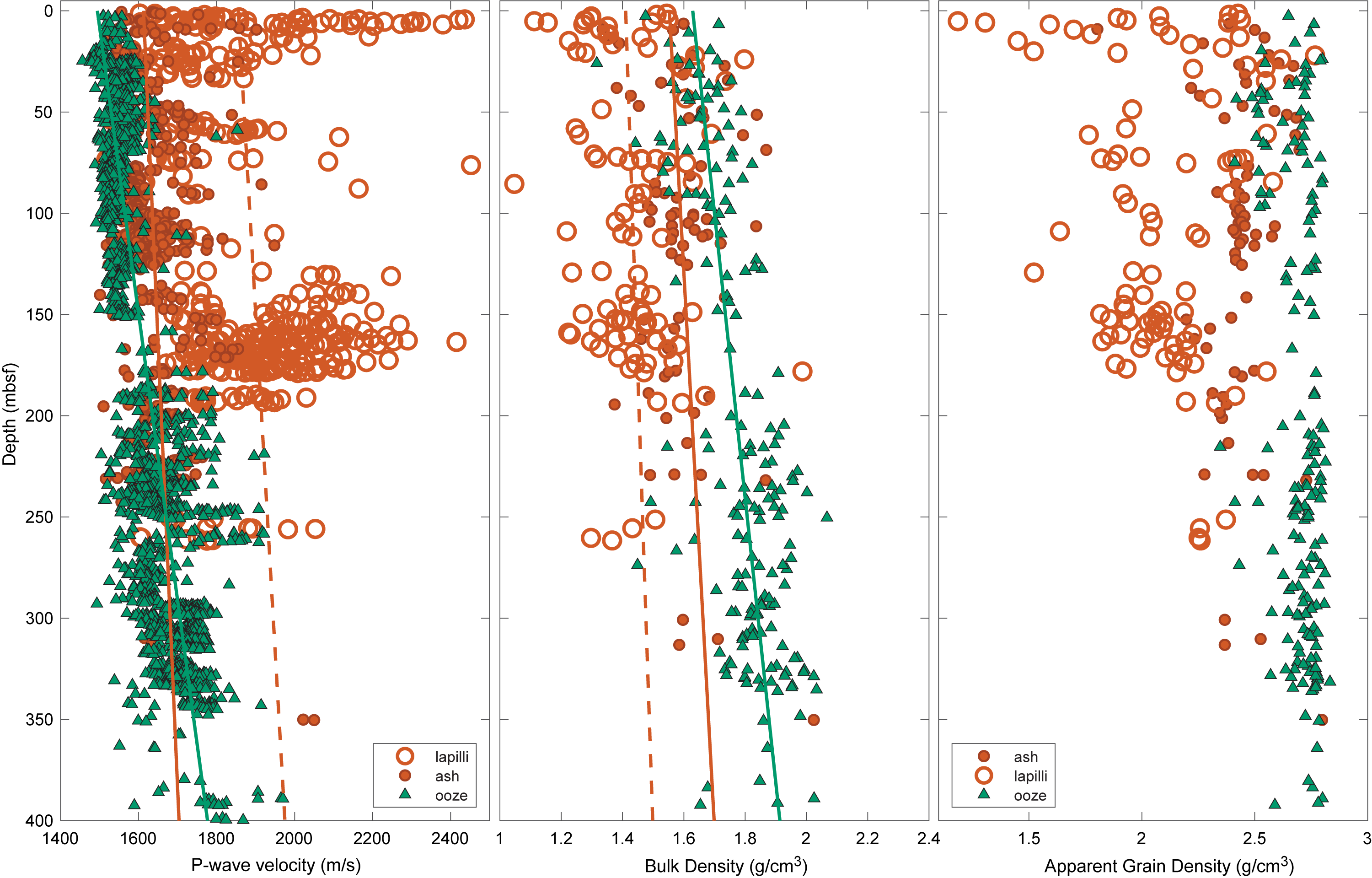
Figure F2. P-wave velocity, bulk density, and grain density of oozes and apparent grain density of volcanic ash and lapilli from rift basin sites.
3.2. Comparison of downhole logging and discrete measurements
Hole U1589C was the only hole that was logged, and thus provides the only opportunity to compare shipboard and in situ measurements. Figure F3 compares logging values of bulk density from Hole U1589C with discrete MAD measurements from Holes U1589A and U1589B. Measurements from intervals with reported coring disturbances are excluded. In general, the agreement for measurements in nonvolcaniclastic intervals is good, even capturing the downhole fluctuations in density, although we note that logging and discrete measurements were conducted in different holes. For nonvolcanic sediment, the mean density measurement of 1.87 ± 0.10 g/cm3 from 16 discrete samples is consistent with the logging value of 1.84 ± 0.11 g/cm3 at corresponding depths. The shipboard measurements have a slightly higher mean density, suggesting that there was minimal sediment expansion during recovery of cores. The difference for volcaniclastic sediment is larger (mean shipboard density of 1.63 g/cm3 compared with a logging density of 1.90 g/cm3), but we have only three samples and measurements are highly variable. In general, this comparison suggests that shipboard discrete density measurements can be assumed to provide reasonable estimates for in situ conditions.
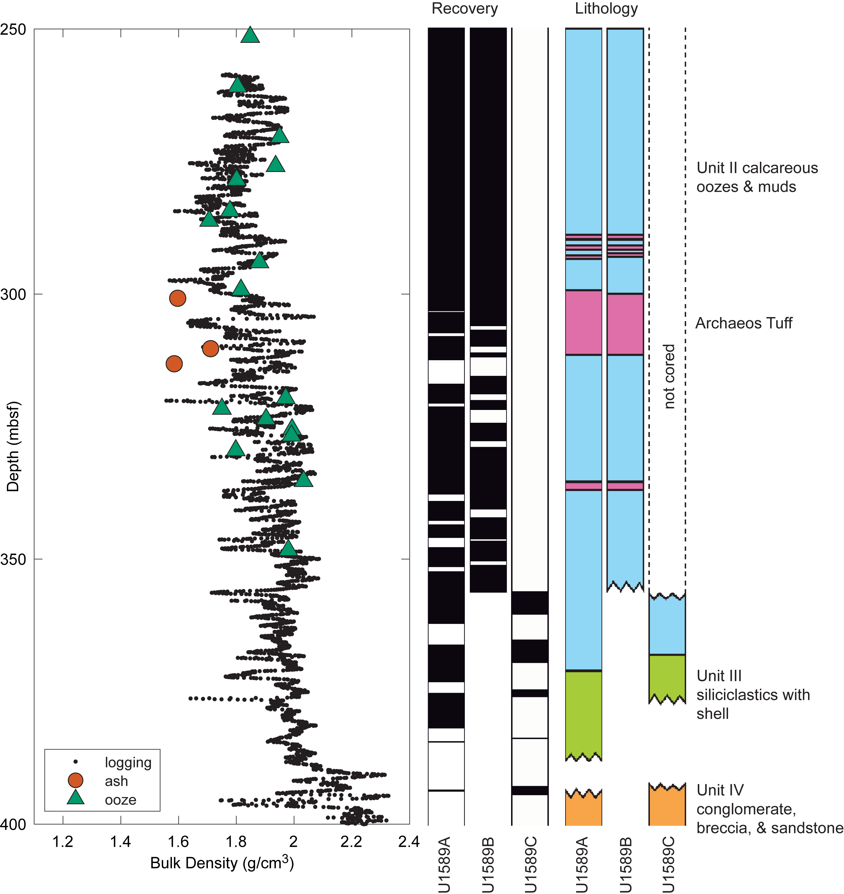
Figure F3. Comparison of downhole logging density and shipboard discrete density.
3.3. Comparison of WRMSL and discrete measurements
To determine the most suitable measurements of physical properties for creating synthetic seismograms, we compare continuous and discrete velocity and density measurements from Sites U1591 and U1592 (Figure F4). Generally, discrete measurements can be assumed to be more reliable than whole-round data because the split cores could be visually assessed for drilling disturbances and discrete measurements could be made on samples with no obvious drilling and recovery disturbances. The disadvantage is that discrete measurements are made at larger intervals.
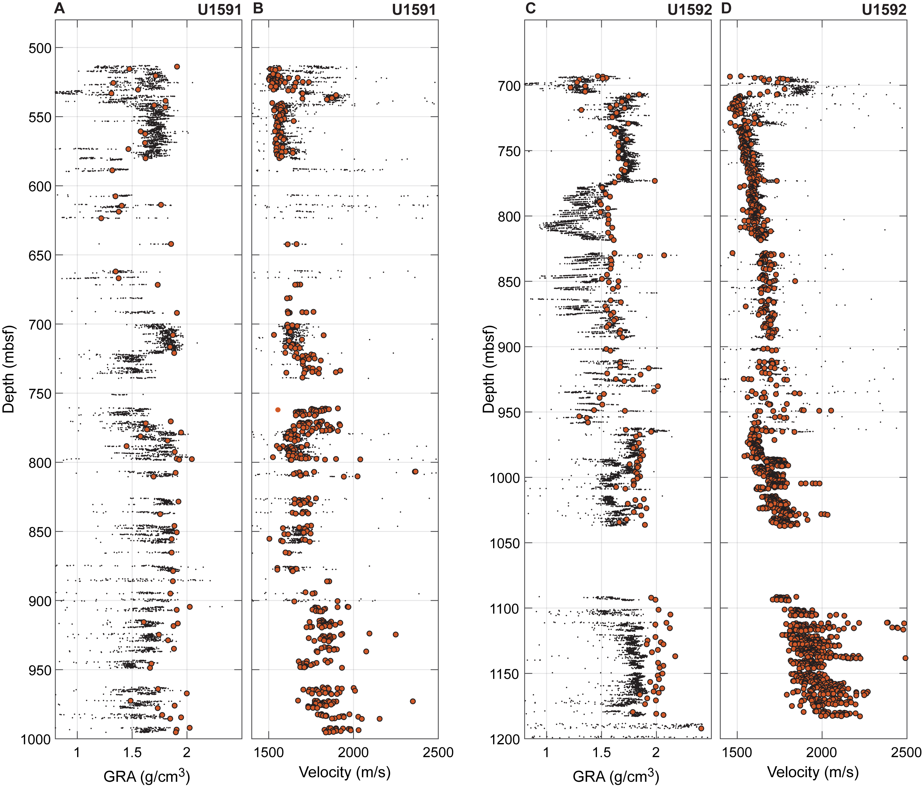
Figure F4. Comparison of shipboard WRMSL density and velocity data with discrete measurements.
As is visible in Figure F4, continuous GRA bulk density measurements exhibit substantial fluctuations, and we observe a misfit between the continuous and discrete density measurements. In shallow depths, discrete measurements show lower densities than continuous measurements, and at greater depths discrete values are higher than continuous measurements (Figure F4A, F4C). As described above, the discrete density measurements align closely with in situ downhole logging data and we accept them as reliable. The observed systematic offset in the continuous density measurements may be a result of cracks and water pockets in partially filled core liners, which lead to overestimated bulk densities for the porous volcanoclastic materials (water pockets) but underestimated bulk densities for compacted sediments at greater depths (cracks). In contrast, P-wave measurements show fewer fluctuations and a closer fit between discrete and continuous data (Figure F4B, F4D).
Therefore, we use discrete density measurements and continuous P-wave velocity measurements as inputs for synthetic wavelet generation. The continuous velocity data ensure a smooth curve, and the discrete density values provide a more accurate representation of bulk properties.
3.4. Core-seismic integration
In the following sections, we describe the results of core-seismic integration for all sites of IODP Expedition 398. All depths are referenced to seismic TWT, which translates to the depth below sea level through the derived velocity model and the time-depth relationships (Tables T1, T2, T3, T4, T5, T6, T7, T8, T9, T10, T11, T12).
3.5. Site U1589
Site U1589 drilled the northeastern Anhydros Basin (Figure F1) to 1068 meters below seafloor (mbsf) (1334 m/s TWT) (Table T1), achieving overall good core recovery (Figure F3A) (Druitt et al., 2024b). Continuous density measurements (WRMSL measurements) are highly scattered in the upper (above ~900 m/s TWT; ~200 mbsf; Unit I) and lower part of the section (below ~1150 m/s TWT; Units III–IV). Core recovery rates significantly decrease in the lower part of the section (below ~1120 m/s TWT; ~400 mbsf; Units III–IV) (Figure F3B).
We correlate this site to Seismic Profile GEOMAR_5019 from Cruise POS538 (Figures F5E, F5F, F6). Although there are six matching reflections in the synthetic and extracted seismograms, the overall fit is not always obvious (Figure F5E, F5F). However, Figure F6 demonstrates a compelling alignment between lithostratigraphic units and major changes in seismostratigraphy (Preine et al., 2022a). The boundary between Units I (volcanic sediments) and II (oozes and calcareous muds) aligns with the prominent unconformity (Horizon h4) previously identified by Preine et al. (2022a) as a major onlap horizon (Figure F6). Below Horizon h4, we identify highly stratified, subparallel reflections corresponding to Unit II (ooze and calcareous mud) (Figure F6). The base of the Archaeos Tuff matches with another unconformity marked by Horizon h3 (Preine et al., 2022a) (Figure F6). The boundary between Units II and III (siliciclastics with shells) does not match an obvious change in the seismic reflection pattern. In contrast, the base of Unit III corresponds to a shift from well-stratified reflections to more diffuse, chaotic reflections, characteristic of Unit IV (oxidized conglomerate, breccia, and sandstone; Horizon h2; Preine et al., 2022a). Unit V (carbonate rocks) is located beneath a high-amplitude reflection, previously referred to as the acoustic basement (Horizon h1; Preine et al., 2022a).
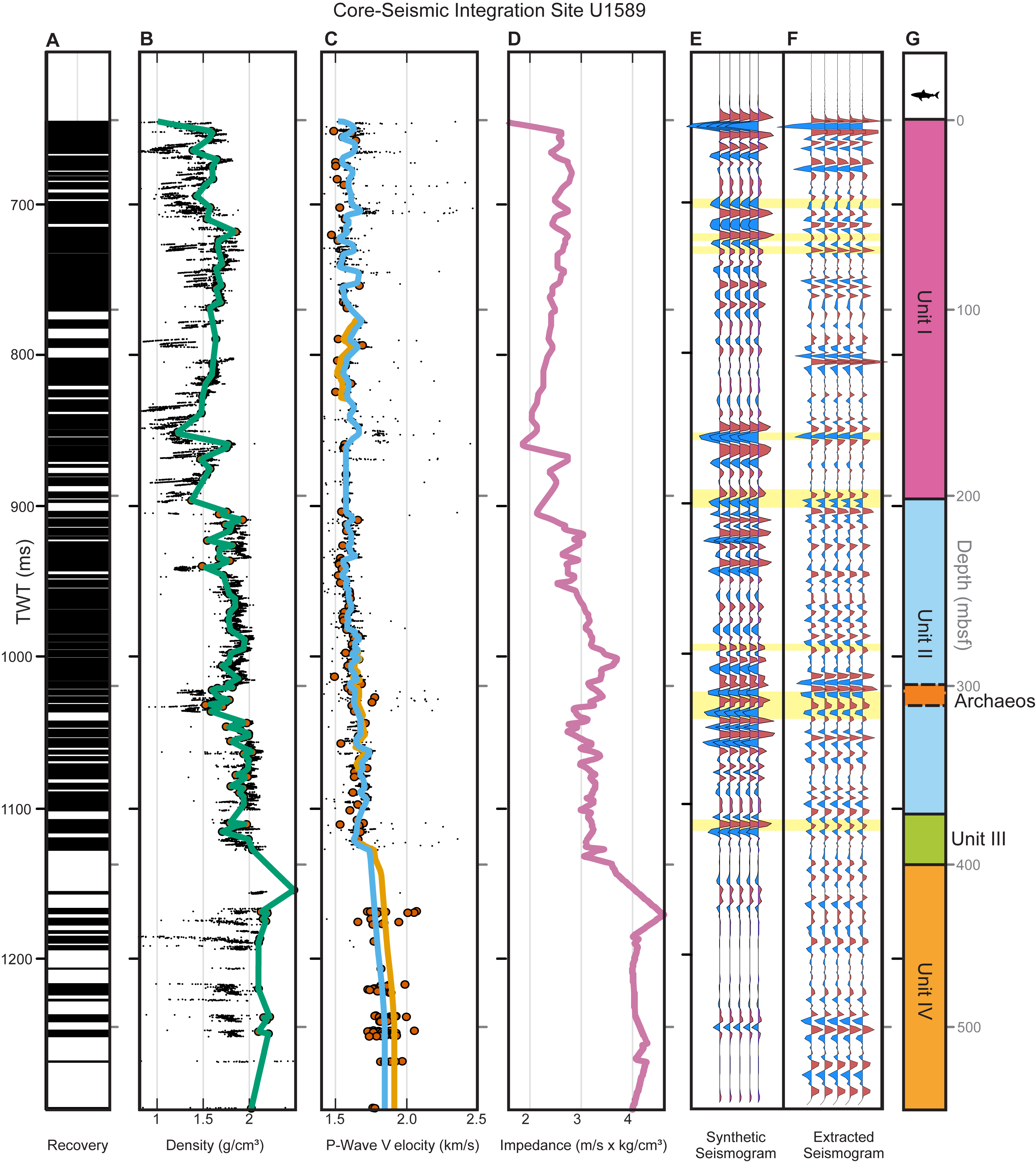
Figure F5. Core-seismic integration, Site U1589.
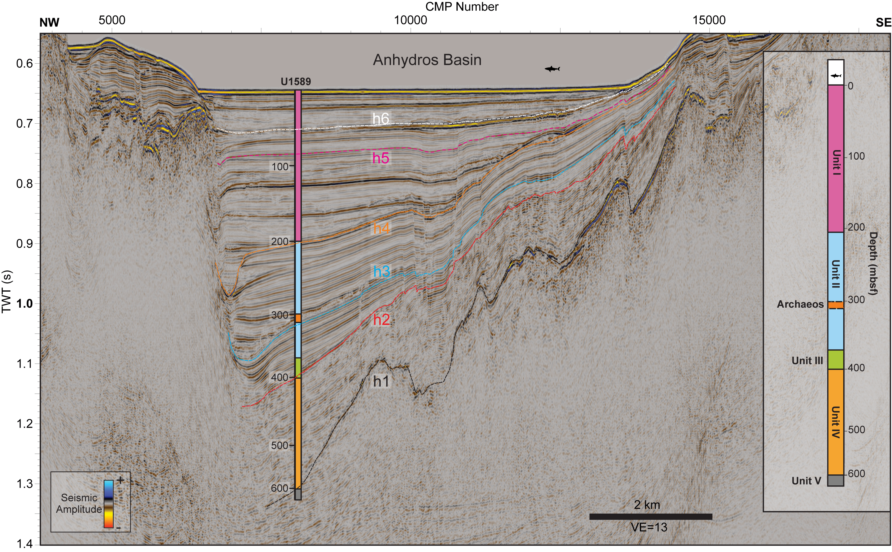
Figure F6. Seismic Profile GEOMAR_5016 crossing Site U1589.
3.6. Site U1590
Site U1590 drilled the western flank of Kolumbo in the southwestern Anhydros Basin (Figure F1) to 1024 mbsf (1250 m/s TWT) (Table T2) with low core recovery throughout with highly scattered discrete measurements (Figure F7A–F7C) (Kutterolf et al., 2024b). The upper part of the section to approximately 620 m/s (~100 mbsf) (Unit I) showed better recovery with a matching reflection between the synthetic and extracted seismograms from Seismic Profile GEOMAR_3001 (Figure F7E–F7G). In the lower part of the section, recovery was so sparse that no reliable correlation between synthetic and extracted seismograms was possible (Figure F7E–F7G). Figure F8 shows Seismic Profile GEOMAR_3001 across Site U1590. However, due to the sparse core recovery, there is no clear correspondence between the boundary of Units I and II and a significant change in the seismostratigraphy, which is generally characterized by chaotic reflection patterns (e.g., Hübscher et al., 2015; Karstens et al., 2023a) close to Kolumbo (Figure F8).
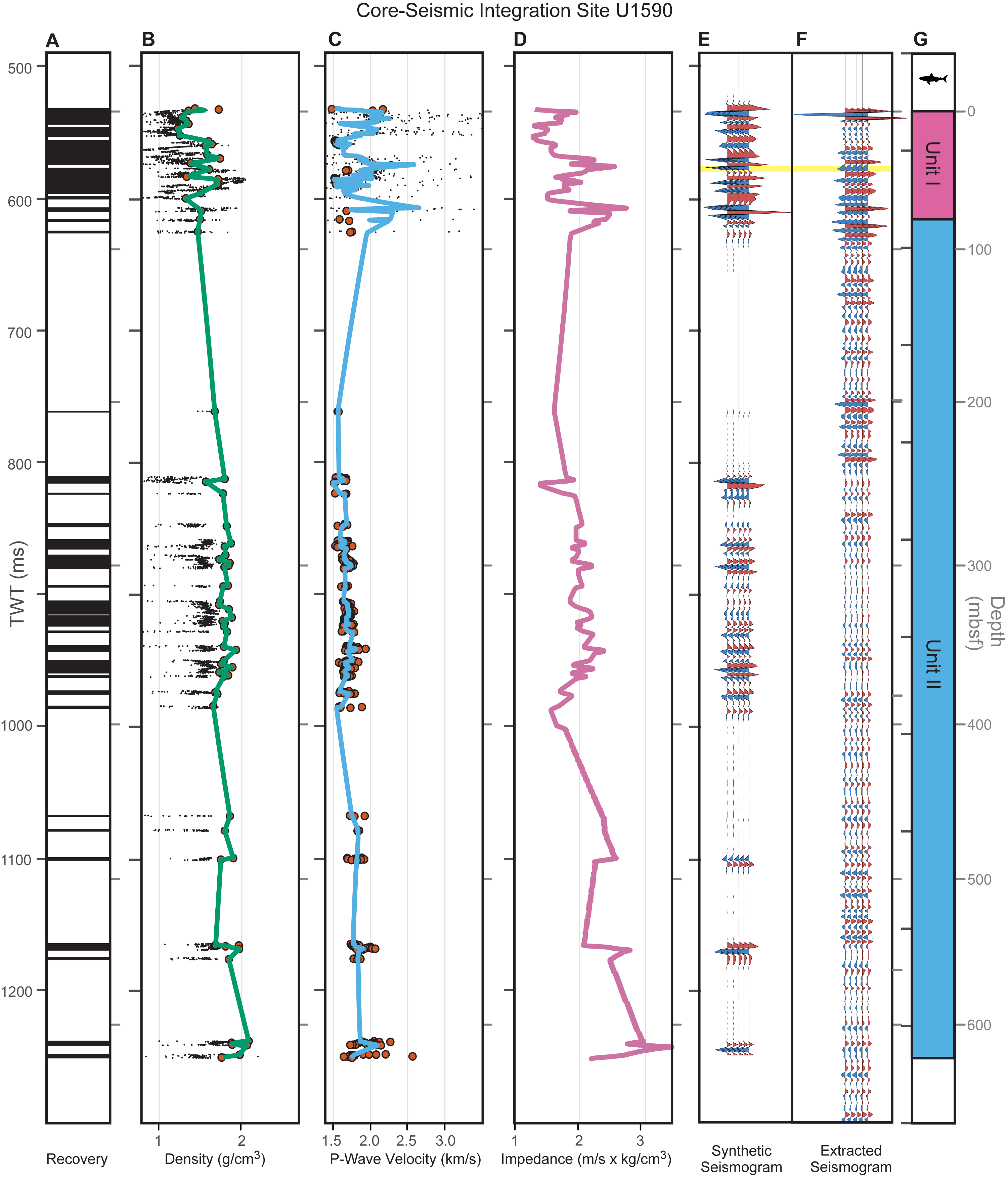
Figure F7. Core-seismic integration, Site U1590.
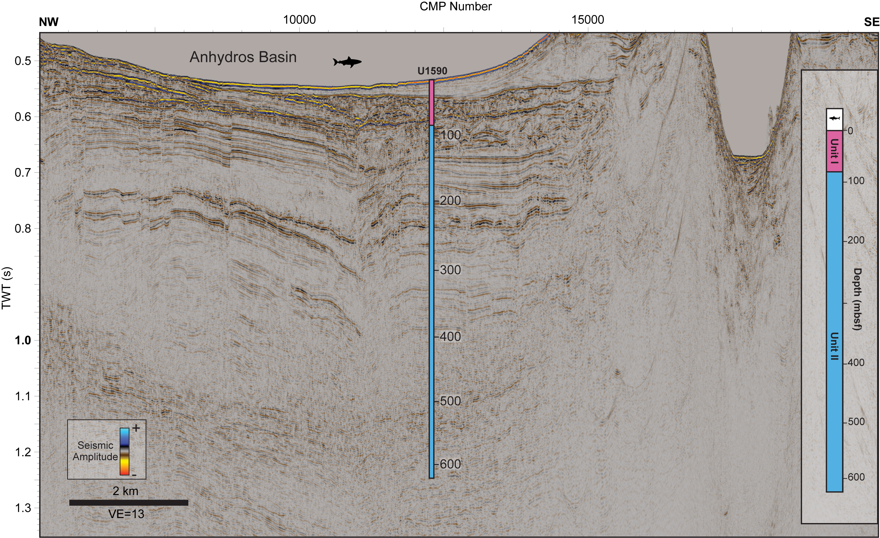
Figure F8. Seismic Profile GEOMAR_3001 crossing Site U1590.
3.7. Site U1591
Site U1591 drilled the Christiana Basin (Figure F1) to 1417 mbsf (1653 m/s TWT) (Table T3) (Druitt et al., 2024c). Overall recovery was good, though several larger gaps occurred, especially in the Archaeos Tuff (Druitt et al., 2024h) (Figure F9A). We identify several matching reflections between the synthetic and extracted seismograms (Seismic Profile GEOMAR_5008) distributed throughout the entire section (Figure F9E–F9G). The velocity model was slightly modified to increase cross correlation, keeping the velocity well within the scattering of measured physical properties (Figure F9B, F9C).
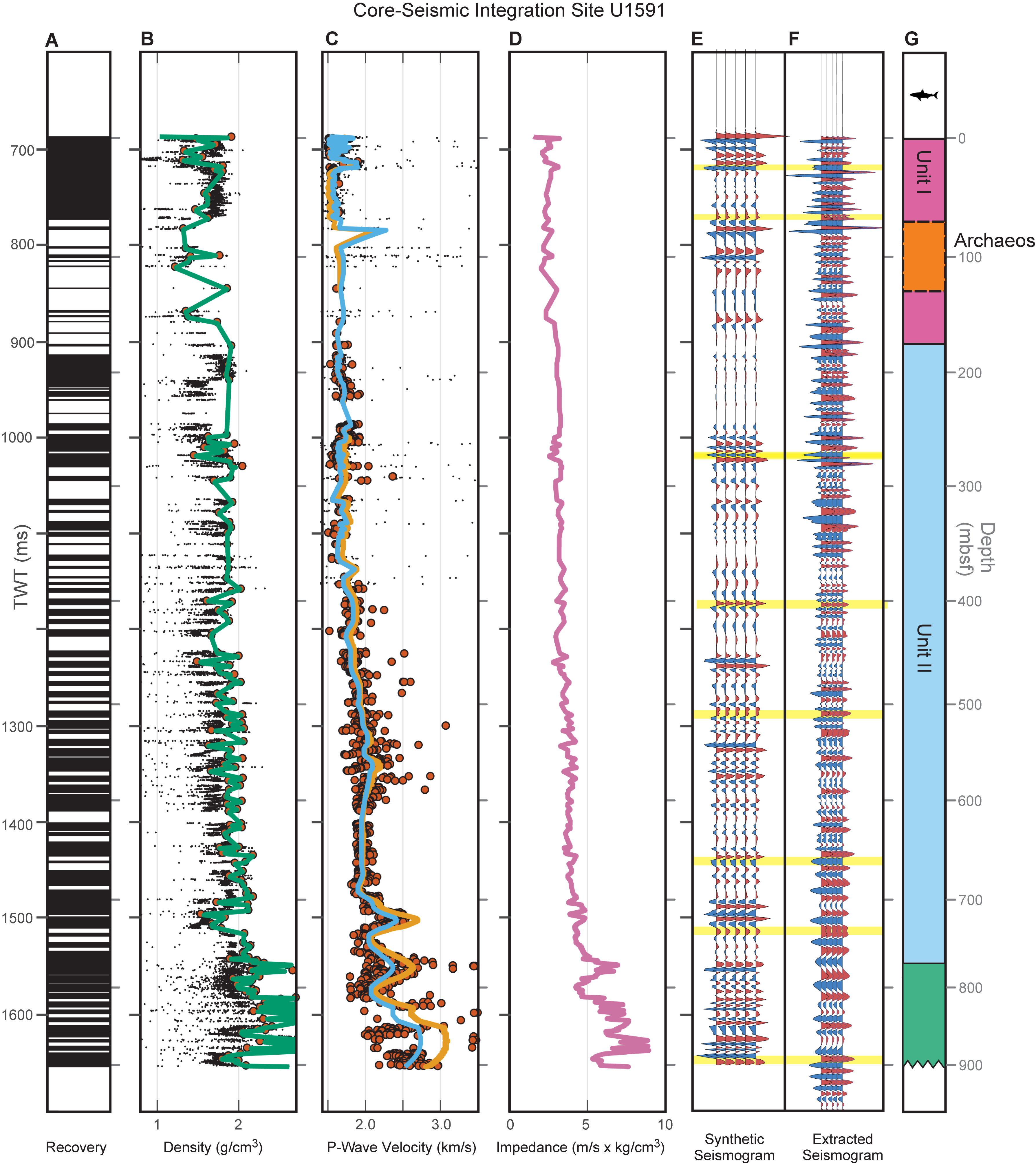
Figure F9. Core-seismic integration, Site U1591.
Figure F10 shows Seismic Profile GEOMAR_5008 crossing the Christiana Basin, Site U1591 and the flank of the Christiana Volcano. Boundaries of lithostratigraphic units correspond to distinct reflections in the seismostratigraphy (Figure F10). The Archaeos Tuff corresponds to a sequence of chaotic to transparent seismic reflections beneath Horizon h5. Its base is defined by a prominent reflection (Figure F10) (Druitt et al., 2024h). The base of Lithostratigraphic Unit I marks the boundary between volcanic sediments and calcareous oozes and muds with volcanic-rich sediments of Unit II. It agrees very well with Horizon h4 (Preine et al., 2022c). Unit III comprises evaporites and minor volcanics and corresponds to the acoustic basement, marked by Horizon h1, which has previously been associated with the top of the Messinian by Preine et al. (2022c).
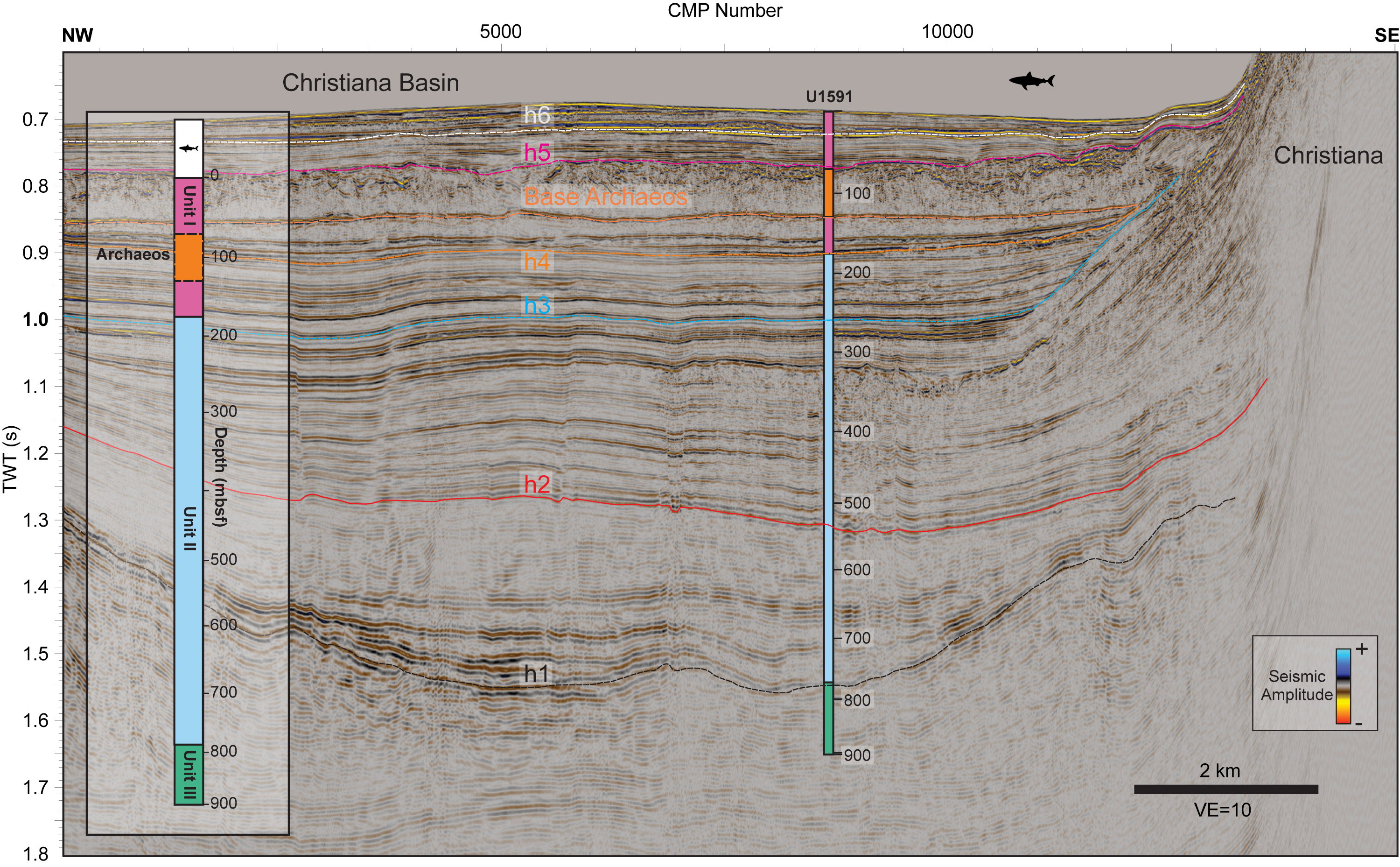
Figure F10. Seismic Profile GEOMAR_5008 crossing Site U1591.
3.8. Site U1592
Site U1592 drilled the central Anafi Basin (Figure F1) to 1209 mbsf (1527 m/s TWT) (Table T4), achieving overall good recovery, particularly in the upper part (Units I and II) (Figure F11A) (Kutterolf et al., 2024c). However, there was a large recovery gap in the lower part (between ~1320 and 1400 m/s; ~350–400 mbsf), which corresponds to the Archaeos Tuff (Druitt et al., 2024h). Core-seismic integration shows several correlations between synthetic seismograms and extracted seismograms from Seismic Profile GEOMAR_5017 (Figure F11E–F11G).
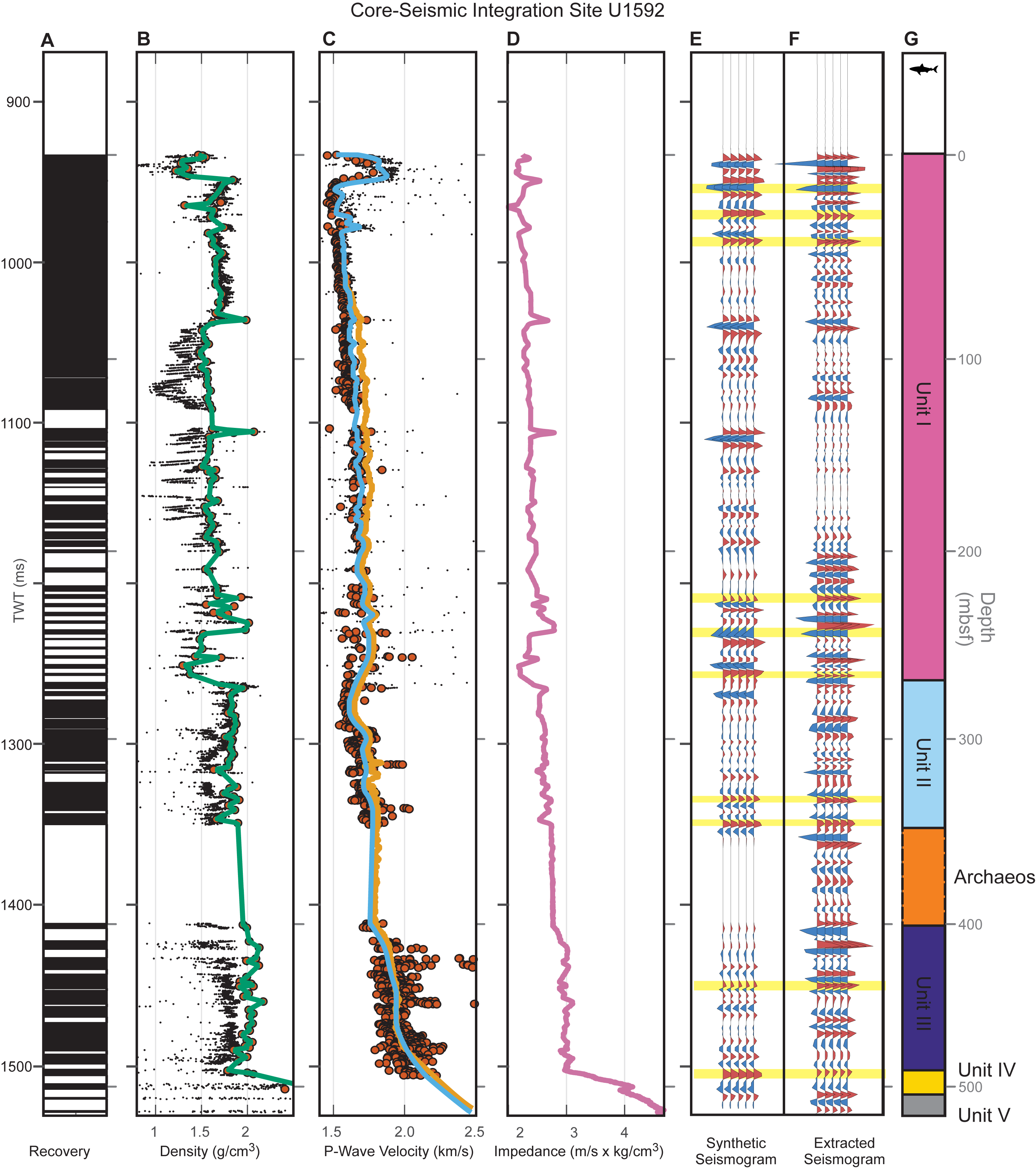
Figure F11. Core-seismic integration, Site U1592.
Figure F12 shows a compelling fit between lithostratigraphic units and seismostratigraphic units. Unit I comprises volcanic and tuffaceous lithologies with minor oozes and muds. Its base matches with a major unconformity (Horizon h6; Preine et al., 2022a) in the seismic profile (Figure F12). Unit II comprises calcareous oozes and muds and corresponds to a stratified seismostratigraphic unit between Horizons h6 and h5 (Preine et al., 2022a). The Archaeos Tuff corresponds to a chaotic to transparent seismostratigraphic unit (between Horizons h5 and h4; Preine et al., 2022a; Druitt et al., 2024h), and Unit III corresponds to a sequence of well-stratified reflections and comprises dolomitic siliciclastics with shells (Figure F12). Unit IV (bioclastic limestone) lies at the base of this well-stratified interval, whereas Unit V (limestone and marble) corresponds to the acoustic basement marked by a high-amplitude reflection (Horizon h1; Preine et al., 2022a) (Figure F12).
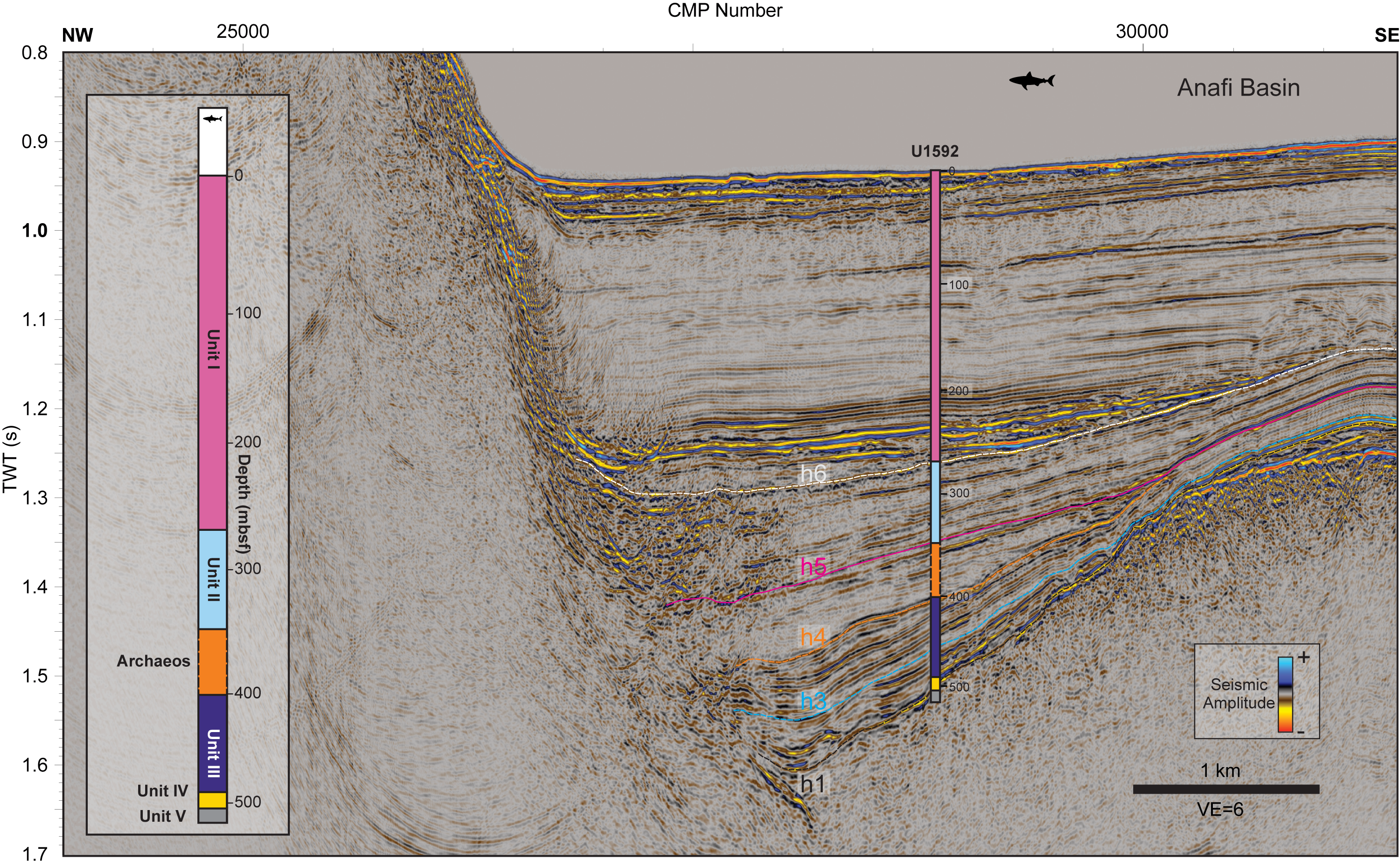
Figure F12. Seismic Profile GEOMAR_5017 crossing Site U1592.
3.9. Site U1593
Site U1593 drilled the southwestern Anhydros Basin close to Kolumbo Volcano (Figure F1) to 647 mbsf (822 m/s TWT) (Table T5) with generally good recovery (Druitt et al., 2024d) (Figure F13A). High scattering of P-wave velocity measurements occurs between ~680 and 760 m/s TWT (~130–190 mbsf), within the Archaeos Tuff (Figure F13B, F13C) (Druitt et al., 2024h). (Figure F7E–F7G). We identify several matching reflections between synthetic and extracted seismograms from Seismic Profile HH06-44 (Figure F13E, F13F).
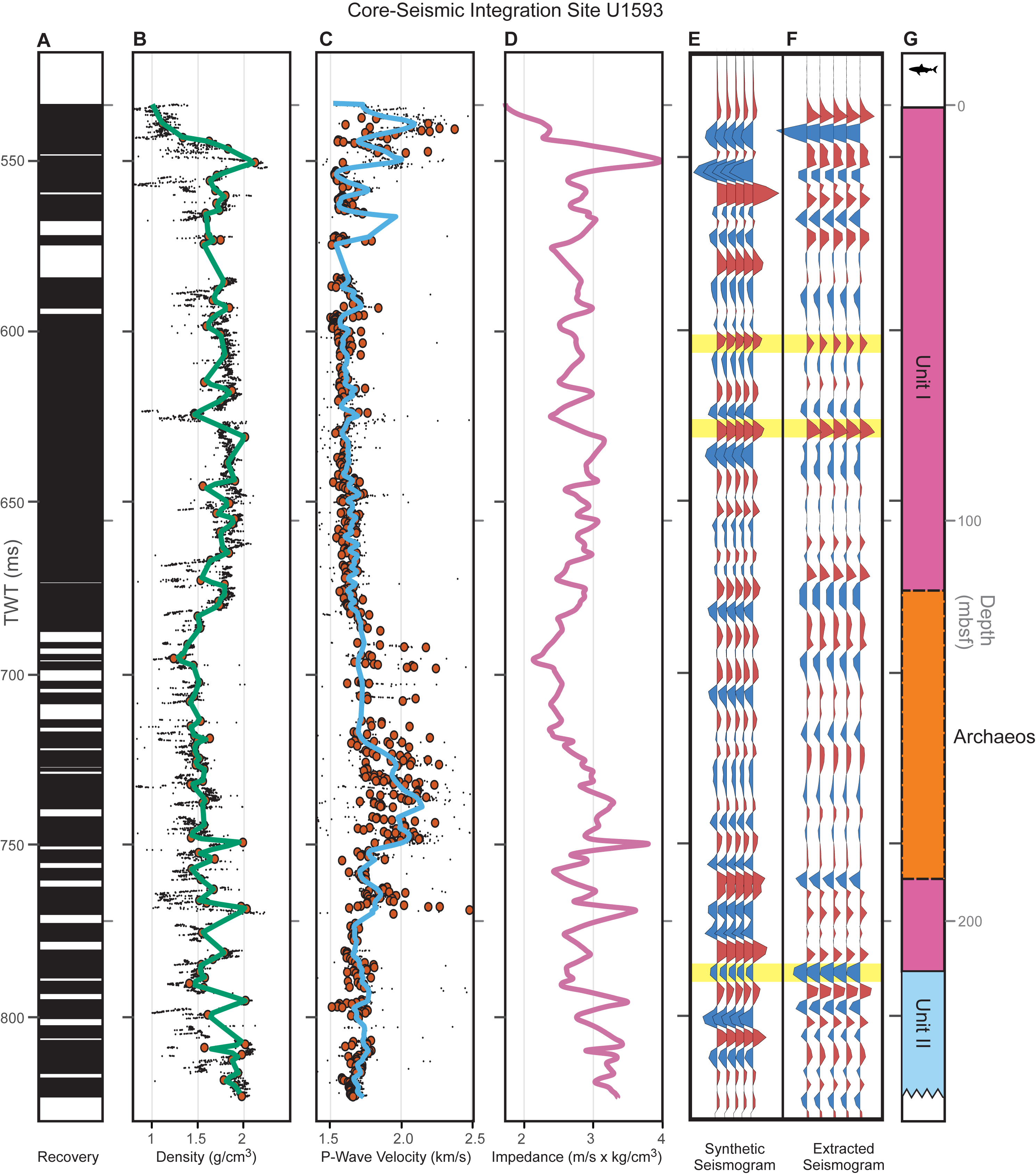
Figure F13. Core-seismic integration, Site U1593.
Figure F14 shows Seismic Profile HH06-44 with Site U1593, demonstrating a compelling fit between lithostratigraphic units and major seismostratigraphic Units (Figure F14). Unit I comprises volcanic and tuffaceous lithologies with minor oozes and muds and its base matches well with Horizon h4 (Preine et al., 2022a), which marks the top of a well-stratified seismostratigraphic unit corresponding to Unit II (calcareous oozes and muds) (Figure F14). The Archaeos Tuff corresponds to a distinct chaotic to weakly transparent seismostratigraphic unit and its base is marked by a prominent reflection above Horizon h4 (Figure F14) (Preine et al., 2022c; Druitt et al., 2024h).
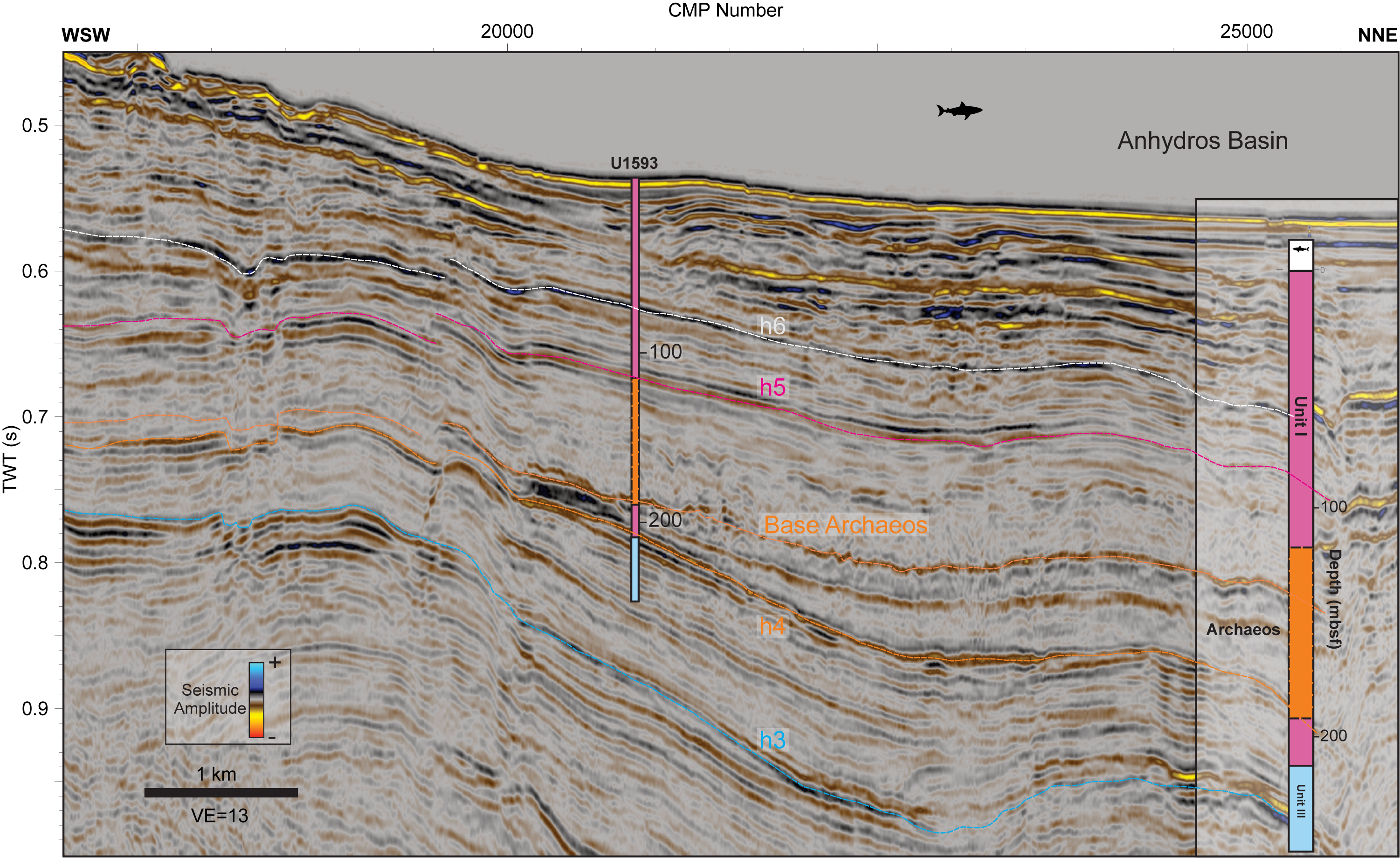
Figure F14. Seismic Profile GEOMAR_5017 crossing Site U1593.
3.10. Site U1594
Site U1594 drilled the southern caldera basin (Figure F1) to 341 mbsf (417 m/s TWT) (Table T6) (Kutterolf et al., 2024d). Because only a single hole was drilled, all depth information is in the CSF-A scale (Kutterolf et al., 2024b). Core-seismic integration of this site, along with all intracaldera sites, has been published in Preine et al. (2024). Core recovery at Site U1594 was generally good (Figure F15A). High data scattering occurred within the density measurements in the upper part (Unit L1) (Figure F15B) and within the P-wave velocity measurements in the lower part (Unit L2) (Figure F15C). Due to the low penetration depth and the scattering of measured physical properties, we identify only one matching reflection between synthetic and extracted seismograms from Seismic Profile GEOMAR_1006 (Figure F15E, F15F). Figure F16 shows Seismic Profile GEOMAR_1006 crossing Sites U1594 and U1595. The boundary between Units L1 and L2 is marked by the transition from the chaotic, weakly reflective Unit S1 to the more stratified Unit S2 (blue horizon in Figure F16) (Preine et al., 2024).
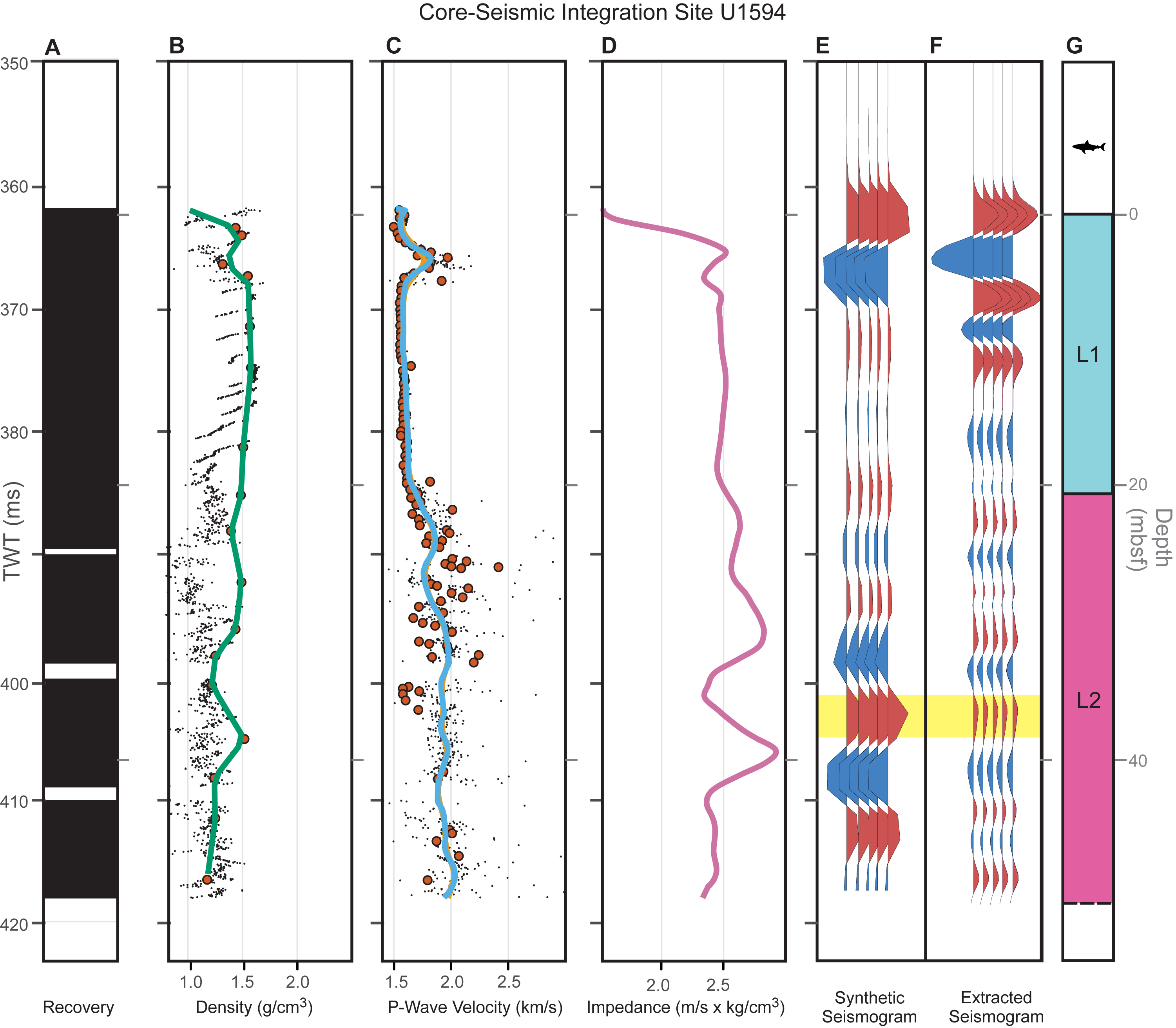
Figure F15. Core-seismic integration, Site U1594.
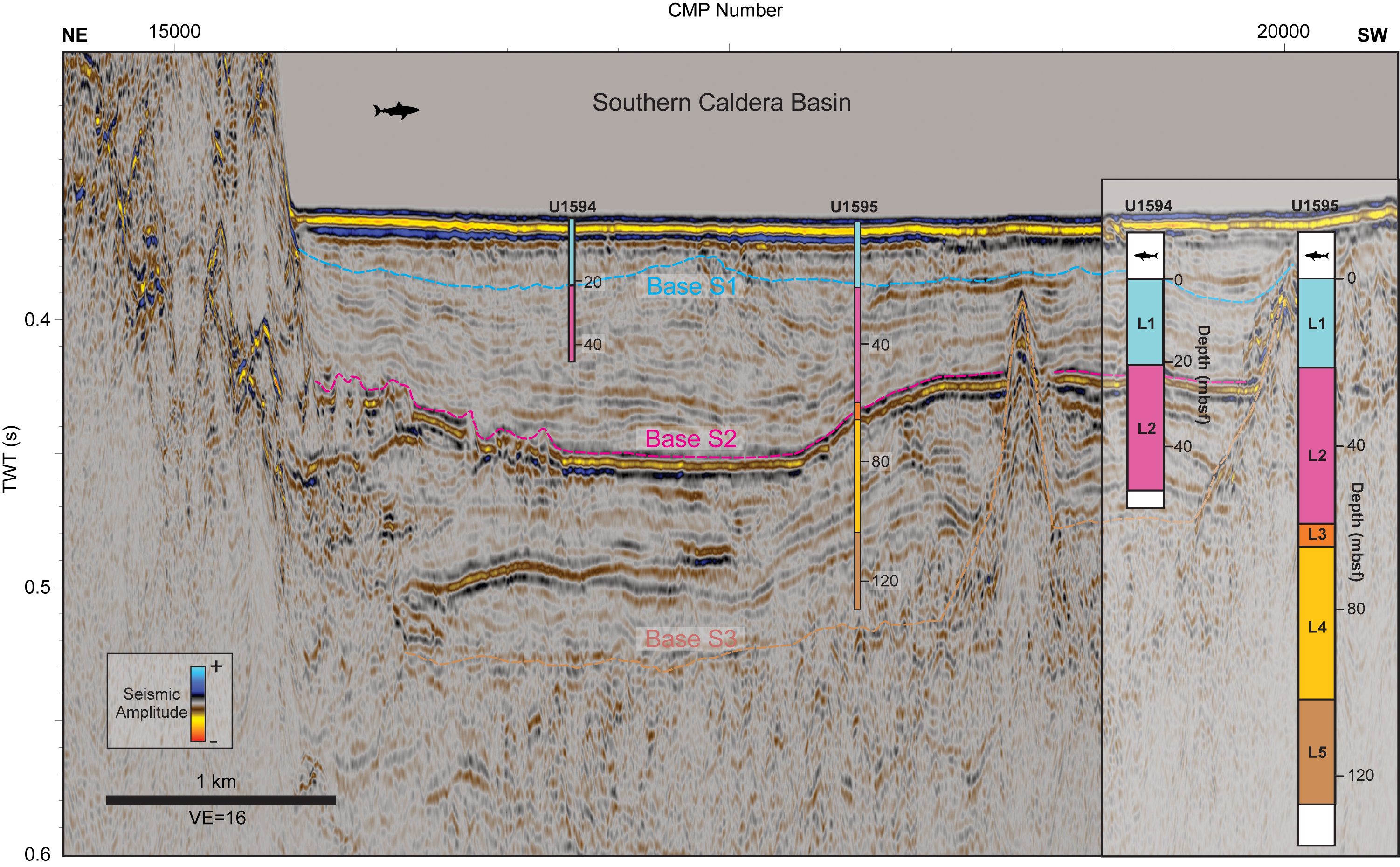
Figure F16. Seismic Profile GEOMAR_1006 crossing Sites U1594 and U1595.
3.11. Site U1595
Site U1595 drilled the southern caldera basin west of Site U1594 (Figure F1) to 417 mbsf (508 m/s TWT) (Table T7) (Druitt et al., 2024e). Good recovery was achieved in the upper part of the section (Units L1–L3), whereas recovery was low in the lower part of the site (Figure F17A). Physical property measurements show high scattering, especially within Units L4 and L5 (Figure F17B, F17C). We identify two matching reflections between synthetic and extracted seismograms from Seismic Profile GEOMAR_1006).
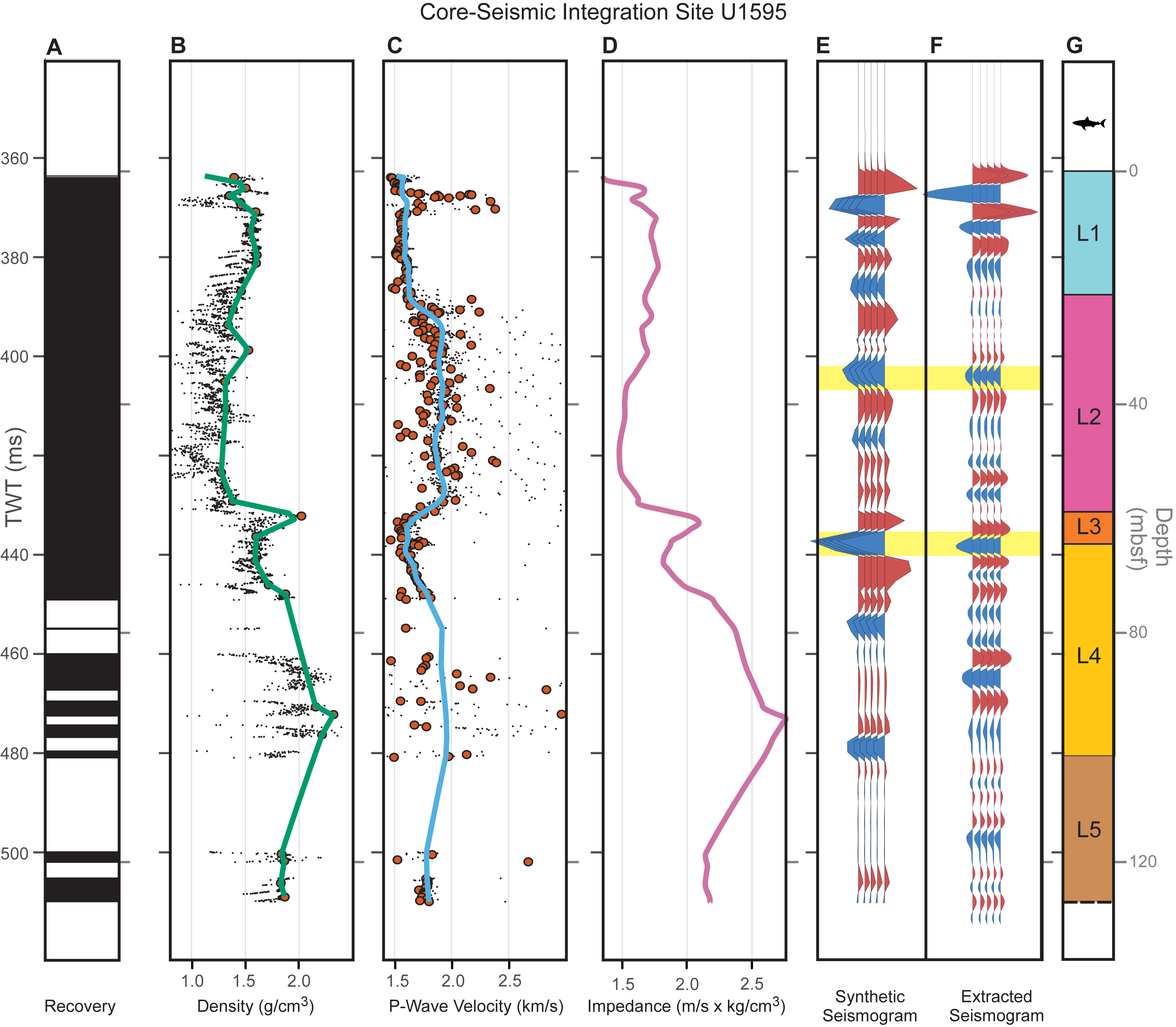
Figure F17. Core-seismic integration, Site U1595.
Figure F16 shows Seismic Profile GEOMAR_1006 crossing Sites U1594 and U1595. The boundary between Units L1 and L2 is marked by the transition from the chaotic, weakly reflective Unit S1 to the more stratified Unit S2 (blue horizon in Figure F16) (Preine et al., 2024). Unit L3 corresponds to a high-amplitude reflection (marked pink in Figure F16) (Preine et al., 2024). The transition between Units L4 (heterogeneous volcanic lithologies, including lithic gravels and sands) and L5 (pumice lapilli, red volcanic ash, and lithics) corresponds to the transition from subparallel reflections to a more chaotic reflection pattern below (Preine et al., 2024). The bottom of Site U1595 is located just above the base of Seismic Unit S3, marking the top of the acoustic basement (brown horizon in Figure F16).
3.12. Site U1596
Site U1596 drilled the northern caldera basin (Figure F1) to 421 mbsf (527 m/s TWT) (Table T8) (Kutterolf et al., 2024e). Because only a single hole was drilled, all depth information is in the CSF-A scale (Kutterolf et al., 2024b). Recovery was generally good (Figure F18A), but high scattering of physical properties occurs throughout the profile (Figure F18B, F18C). Due to the low penetration depth and the scattering of the measured physical properties, it was difficult to identify matching reflections between synthetic and extracted seismograms from Seismic Profile GEOMAR_1006. Figure F19 shows Seismic Profile GEOMAR_1006 crossing Sites U1596 and U1597. Similar to sites U1594 and U1595, the boundary between Units L1 and L2 is marked by the transition from the chaotic, weakly reflective Unit S1 to the more stratified Unit S2 (blue horizon in Figure F19) (Preine et al., 2024).
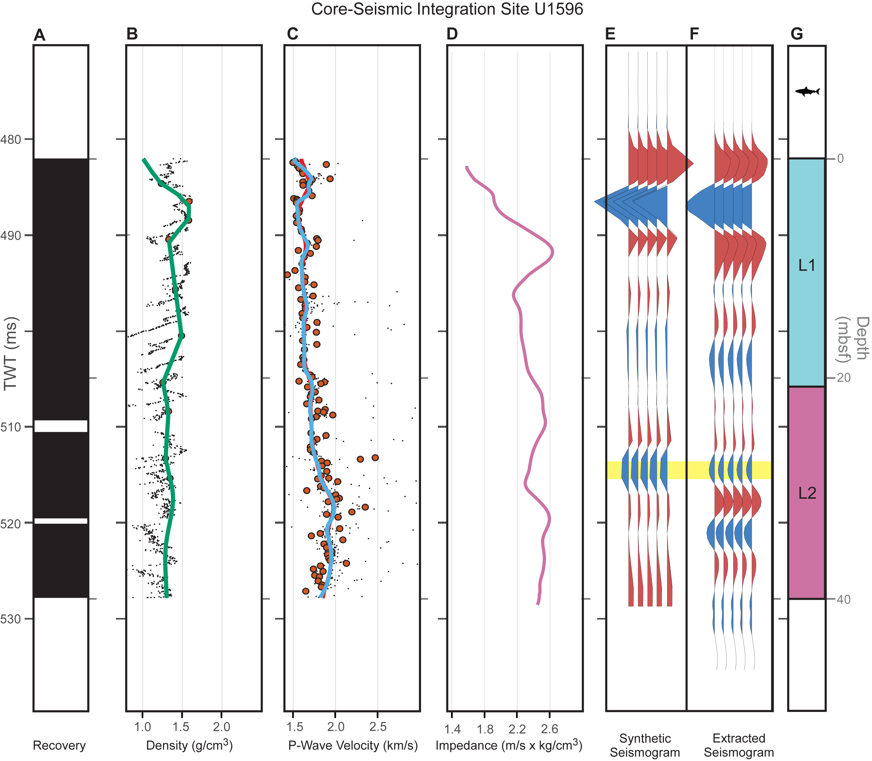
Figure F18. Core-seismic integration, Site U1596.
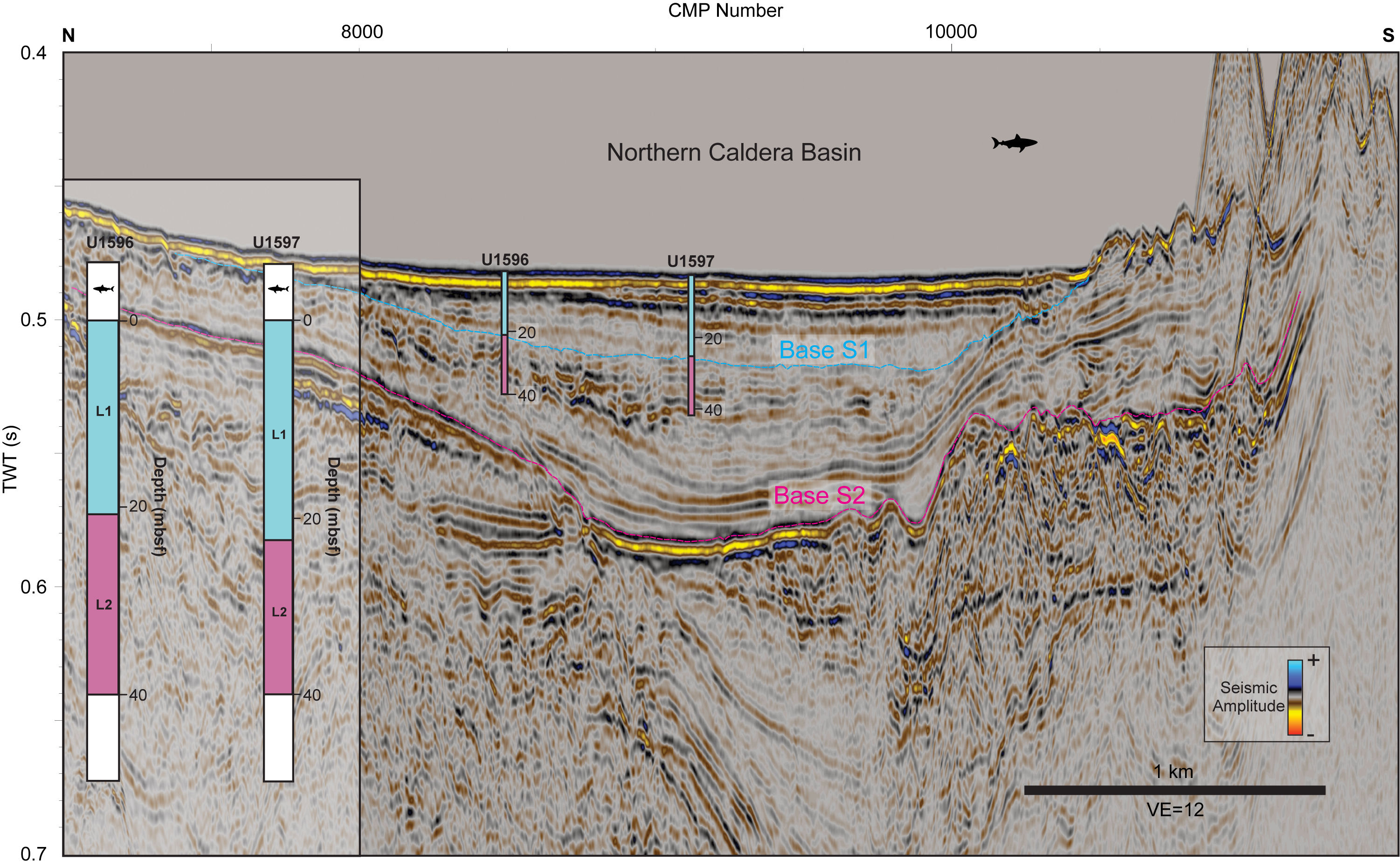
Figure F19. Seismic Profile GEOMAR_1006 crossing Sites U1596 and U1597.
3.13. Site U1597
Site U1597 drilled the northern caldera basin south of Site U1596 (Figure F1) to 424 mbsf (534 m/s TWT) (Table T9) (Druitt et al., 2024f). Core recovery was generally good (Figure F20A), though there was high scattering in the GRA bulk density measurements (Figure F20B). Figure F19 shows Seismic Profile GEOMAR_1006 crossing Sites U1596 and U1597. As with Sites U1594–U1596, the boundary between Units L1 and L2 is marked by the transition from the chaotic, weakly reflective Unit S1 to the more stratified Unit S2 (marked blue in Figure F19 (Preine et al., 2024).
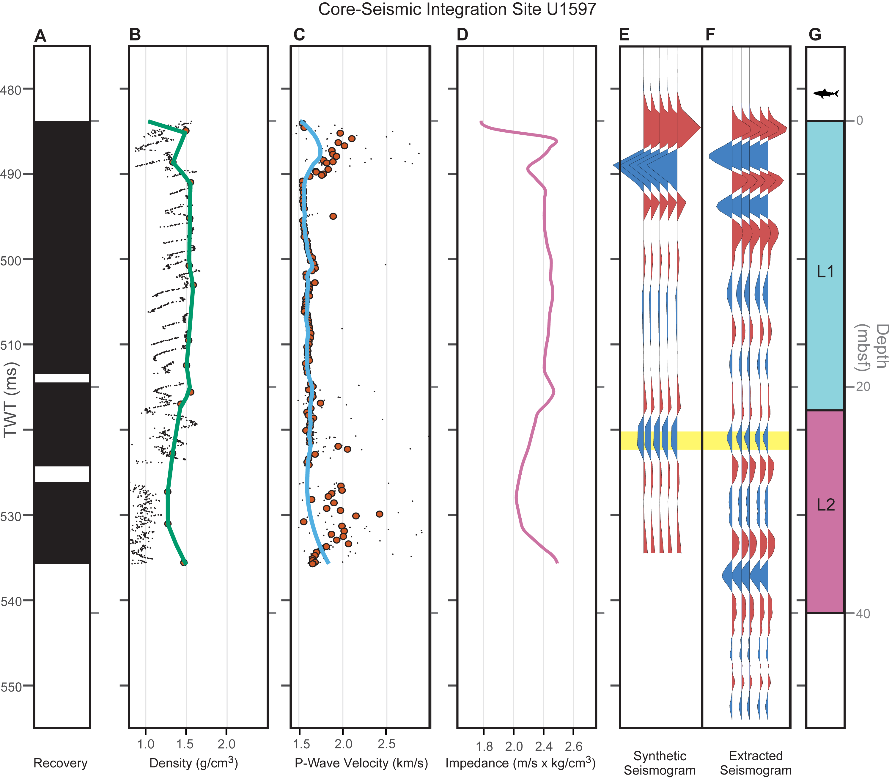
Figure F20. Core-seismic integration, Site U1597.
3.14. Site U1598
Site U1598 drilled the Christiana Basin west of Site U1591 (Figure F1) to 614 mbsf (814 m/s TWT) (Table T10) (Kutterolf et al., 2024f). Unit I in general had good recovery, though there was a larger gap at 722 m/s TWT. Very sparse recovery occurred around 780 m/s TWT (~60 mbsf, corresponding to the Archaeos Tuff; Druitt et al., 2024h) (Figure F21A–F21C). Correlation between synthetic and extracted seismograms from Seismic Line GEOMAR_5009 shows three matching reflections, except for the base of Unit I, which corresponds to a high-amplitude reflection (Figure F21E–F21G). Figure F22 shows that the top of the Archaeos Tuff corresponds to Horizon h5, marking the transition from well-stratified to more chaotic reflections (Preine et al., 2022b; Druitt et al., 2024h).
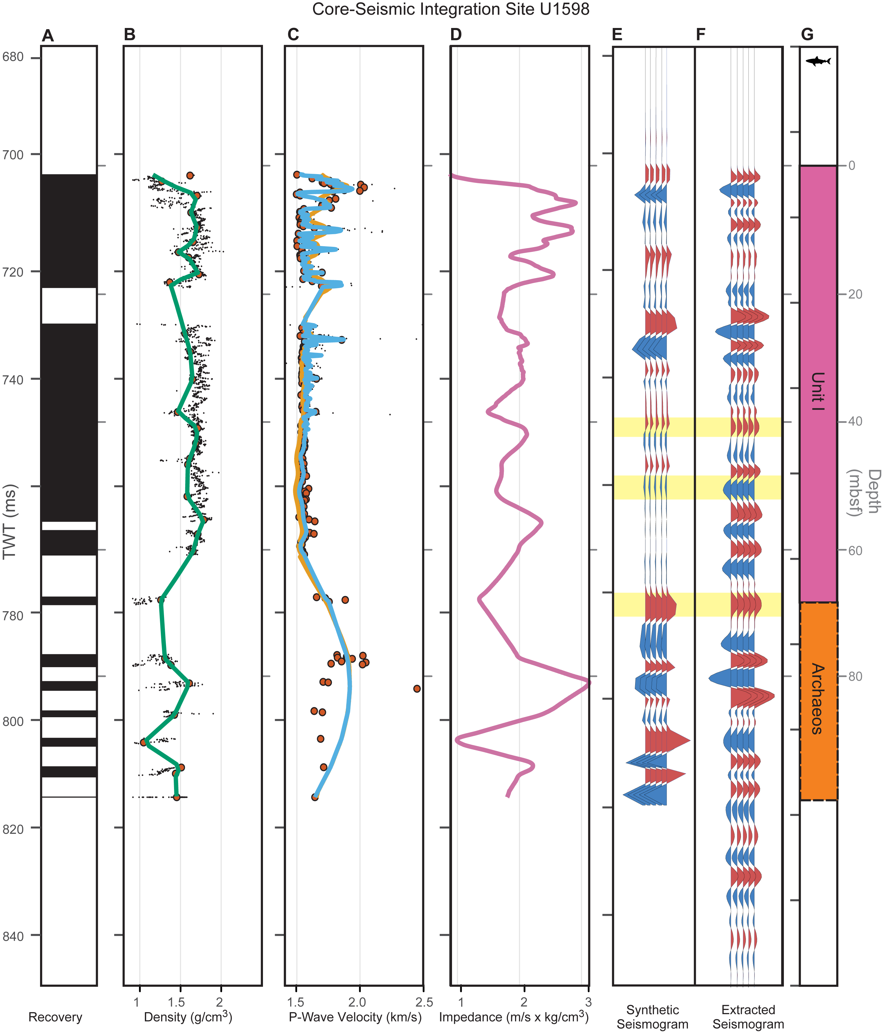
Figure F21. Core-seismic integration, Site U1598.
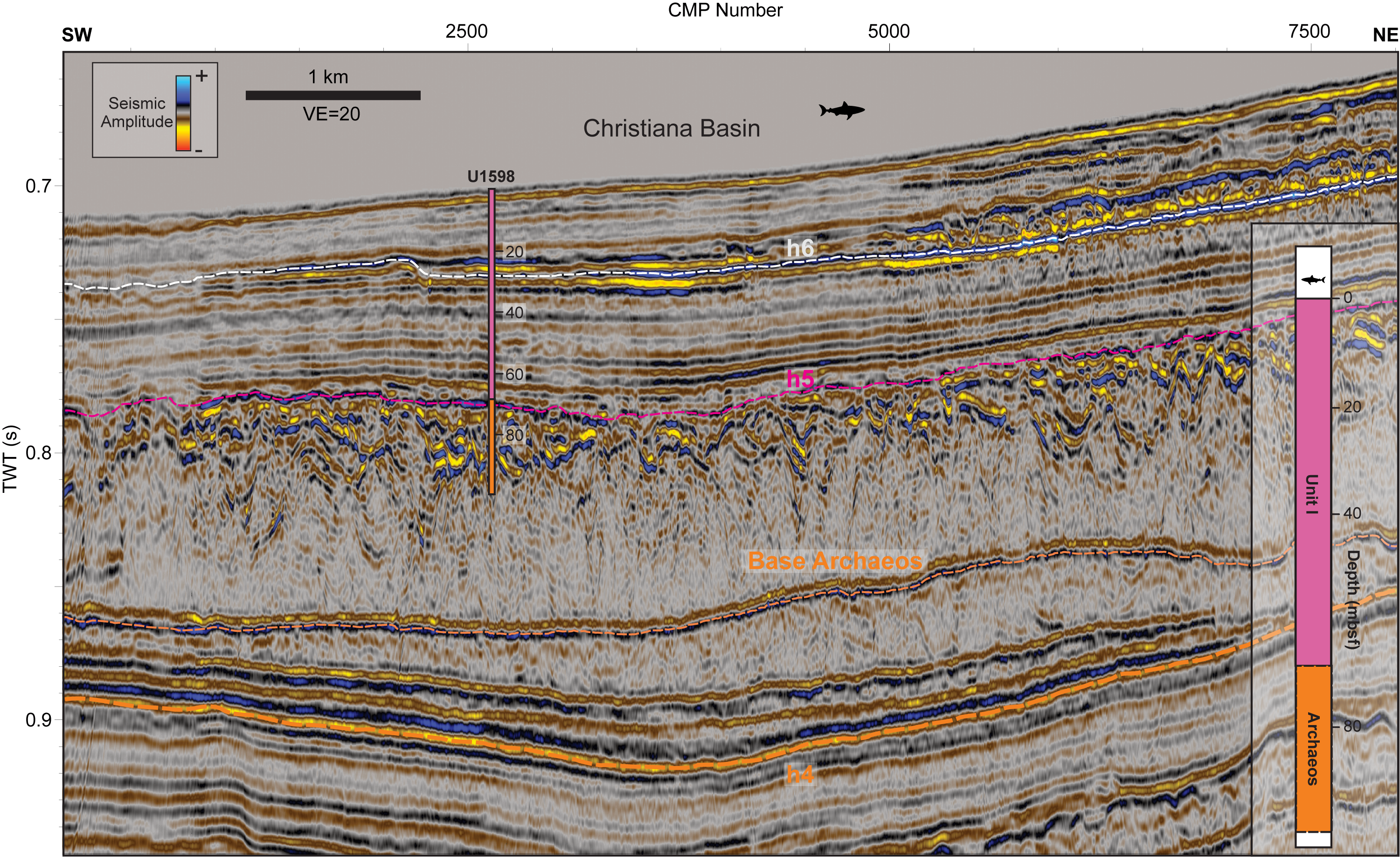
Figure F22. Seismic Profile GEOMAR_5009 crossing Site U1598.
3.15. Site U1599
Site U1599 drilled the western Anafi Basin (Figure F1) to 1278 mbsf (1559 m/s TWT) (Table T11) (Druitt et al., 2024g). Recovery was generally good but decreased from ~1150 m/s TWT (~330 mbsf) downward (Units III and IV) (Figure F23A). The seafloor was not recovered at this site, explaining the gap between the seafloor in the seismic section and the synthetic seismogram from Seismic Profile HH06-19 (Figure F23E–F23G). We identify matching reflections between synthetic and extracted seismograms (Figure F23E–F23G) within Unit I and at the boundary between Units I and II (Figure F23C). We identify a distinct interval of low density and high P-wave velocity below 1000 m/s TWT (~170 mbsf) that corresponds to the depth of the Archaeos Tuff.
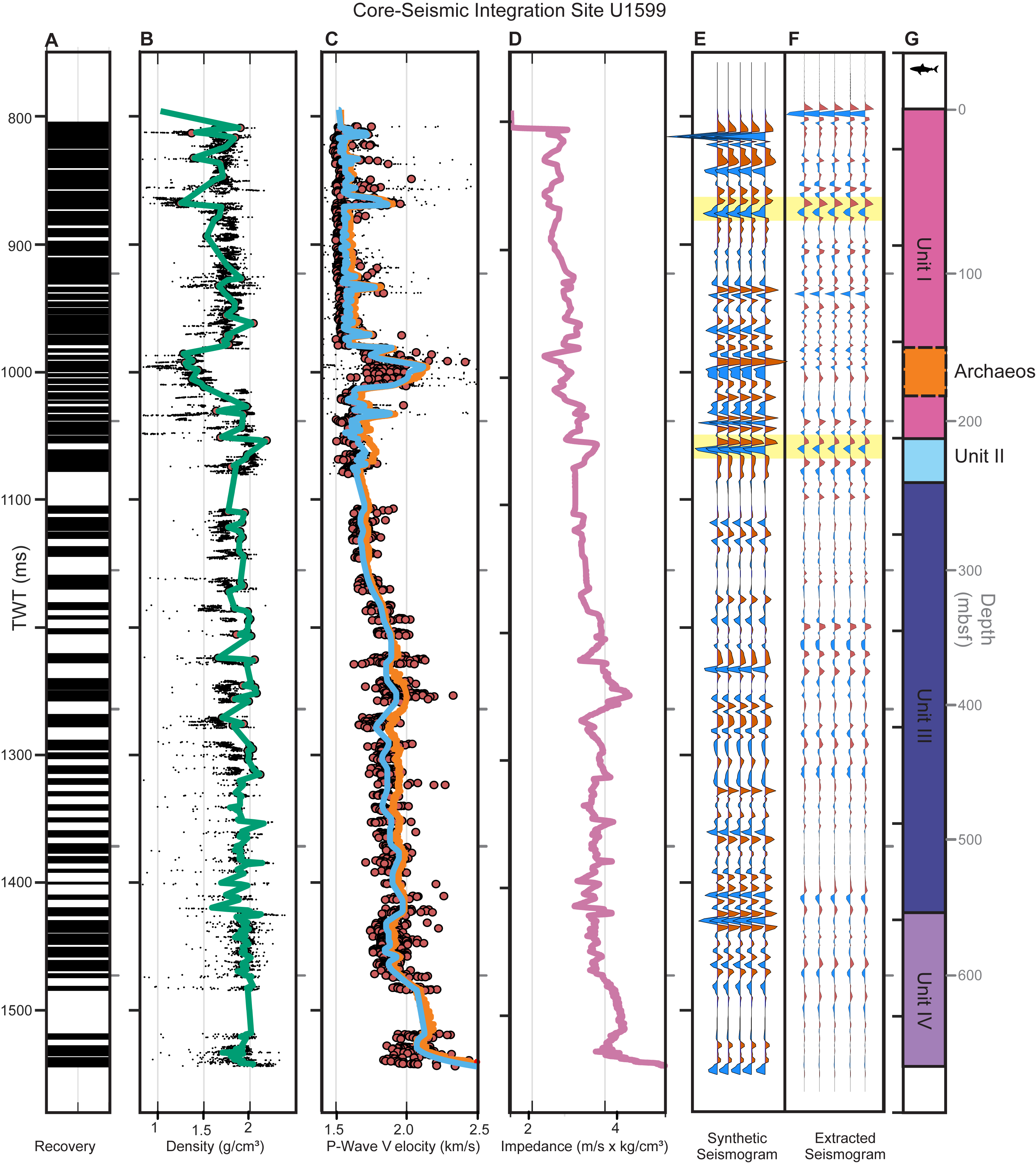
Figure F23. Core-seismic integration, Site U1599.
Figure F24 shows Seismic Profile HH06-19 crossing Site U1599 in the southwestern Anhydros Basin (Figure F1). The Archaeos Tuff corresponds to a thin package of chaotic reflections (Preine et al., 2022b; Druitt et al., 2024h), with a channel-like top reflection (Horizon h5; Figure F24). The boundary between Unit I (volcanic sediments, [organic-rich] ooze, and tuffaceous ooze) and II (organic ooze and minor ash and tuffaceous) is marked by a change to well-stratified, subparallel reflections (Horizon h4; Figure F24). The base of Unit II is marked by a change to lower amplitude reflections (Figure F24) and the base of Unit III corresponds to a change to incoherent, low amplitude reflections (Horizon h2; Figure F24) corresponding to Unit IV (micritic and calcareous sandstones).
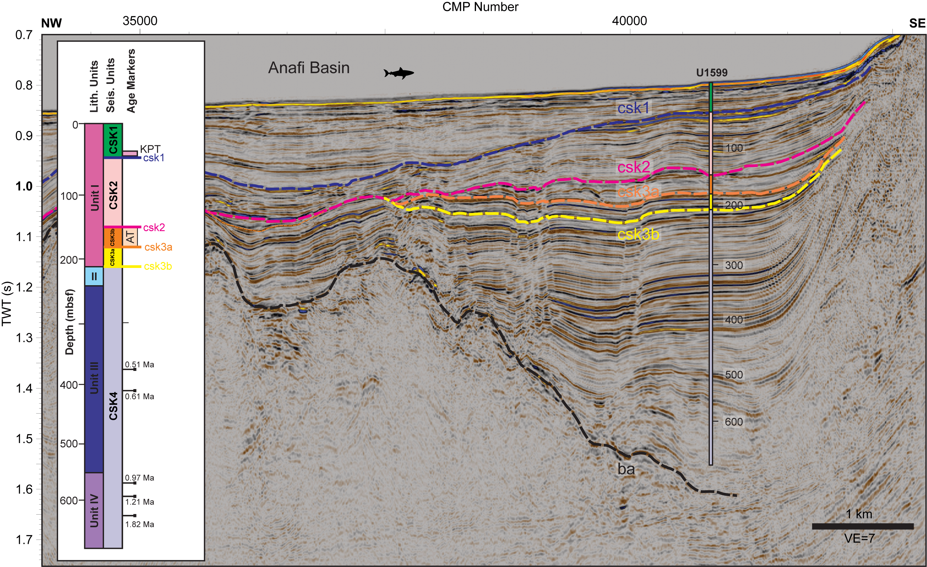
Figure F24. Seismic Profile HH06-16 crossing Site U1599.
3.16. Site U1600
Site U1600 was drilled on top of the Anhydros Horst (Figure F1) to 509 mbsf (643 m/s TWT) (Kutterolf et al., 2024g) (Table T12). Recovery was good in the upper part (Unit I) but sparse below ~550 m/s TWT (~75 mbsf) (Figure F25A). Correlation between synthetic and extracted seismograms from Seismic Profile HH06-17 shows matching reflections at the boundary of Unit I (volcanic and tuffaceous lithologies, bioclastic ash and lapilli and minor calcareous muds/sand) and Unit II (organic-rich calcareous mud/sand with shells, calcareous mud/sand, sandstone and rare ash pods), as well as at the boundary of Unit II and Unit III (ultramafic rocks), which is represented by an anomalously high-amplitude reflection (Figure F25E–F25G). Figure F26 shows Seismic Profile HH06-17 with the interpretation from Preine et al. (2022a). The base of the Archaeos Tuff corresponds to Horizon h5 and the base of Unit I to Horizon h3. The boundary of Unit II and Unit III corresponds to a high-amplitude reflection, marking the top of the acoustic basement.
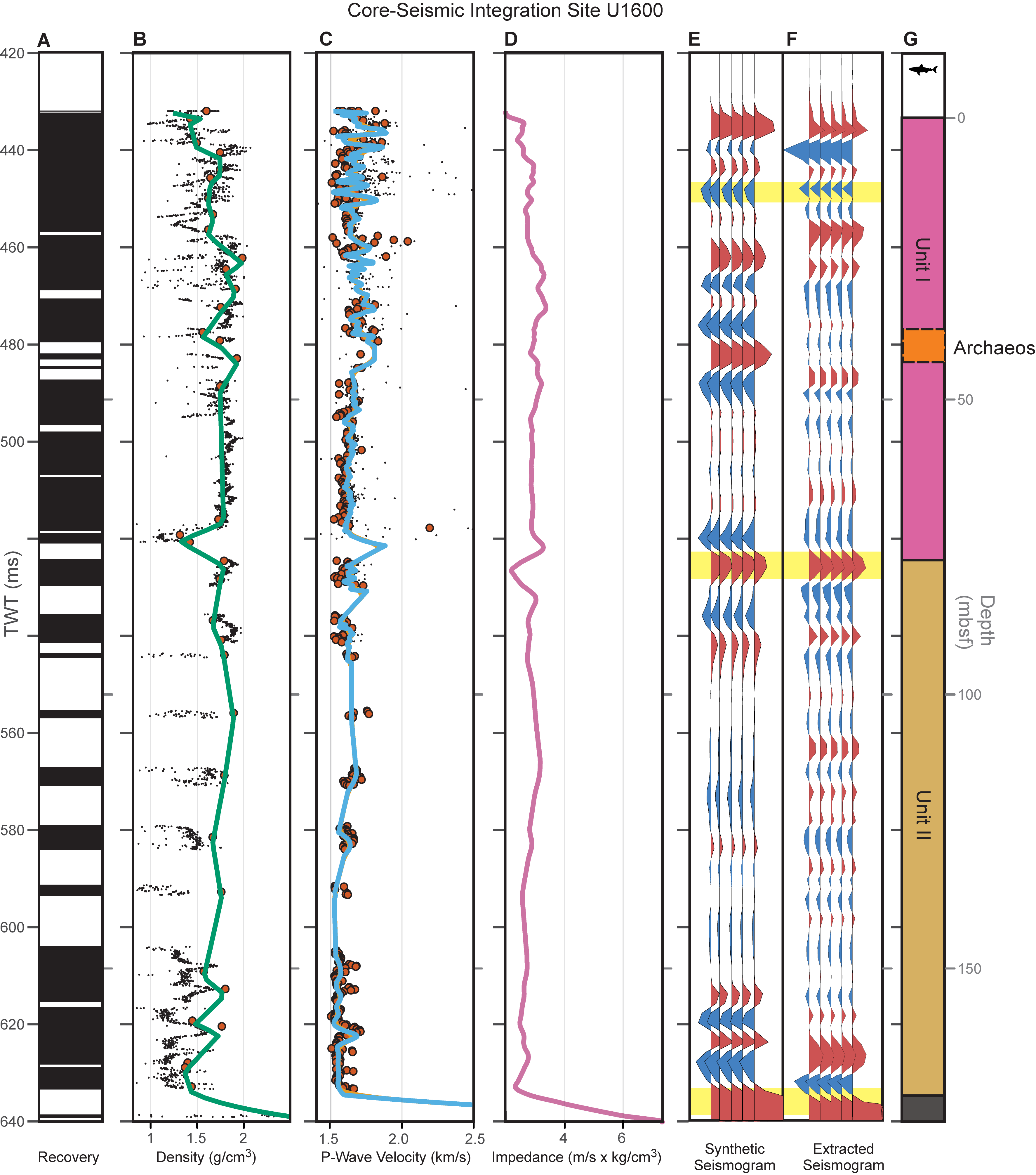
Figure F25. Core-seismic integration, Site U1600.
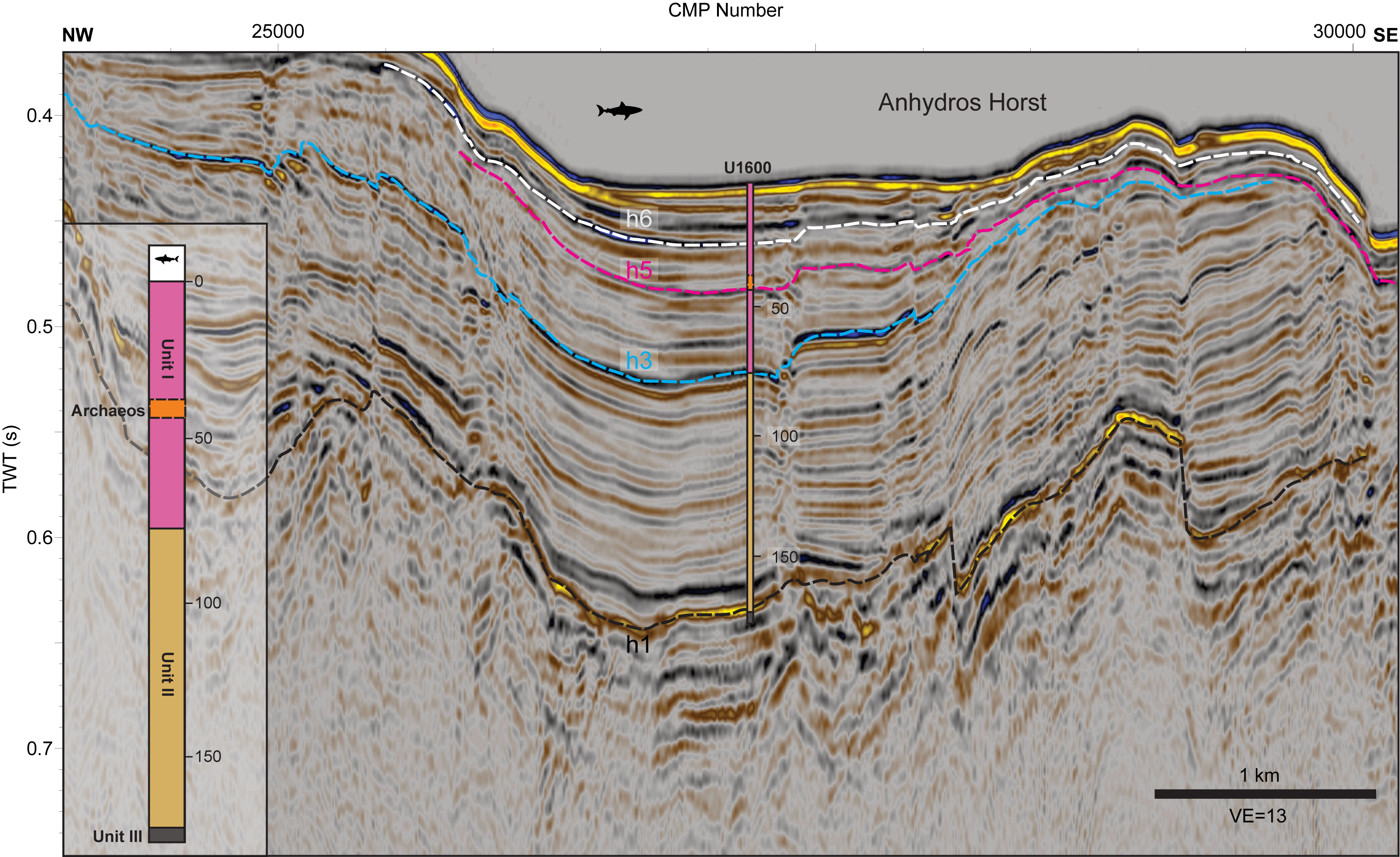
Figure F26. Seismic Profile HH06-17 crossing Site U1600.
4. Summary
We have presented the results of core-seismic integration across the 12 sites of Expedition 398. Comparing shipboard measurements of bulk density with in situ logging at one hole (U1589C) and limited intervals with measurements of density suggests that MAD shipboard measurements should provide reasonable estimates for in situ conditions. Continuous GRA bulk density measurements show higher densities in shallower intervals and lower densities in deeper intervals, which led us to use the discrete MAD measurements for core-seismic integration. The correlation between synthetic and extracted seismograms varied across sites because of recovery gaps and the scattering of physical properties. However, we showed that lithologic boundaries correspond well to previously mapped unconformities and correlated conformities in the multichannel seismic reflection data, which supports the reliability of the presented core-seismic integration.
The Archaeos Tuff, identified across all sites except for within the caldera and at the flank of Kolumbo (Sites U1590 and U1594–U1597), often corresponded to intervals of poor recovery or high scatter in physical property measurements (Druitt et al., 2024h), presenting challenges for core-seismic integration. At most sites, the boundary between mostly volcanic lithologies to calcareous oozes matches prominent and laterally traceable reflections, marking a distinct change from generally chaotic to well-stratified reflections. Sites within the Santorini Caldera (Sites U1594–U1597) generally showed highly variable physical property profiles due to the heterogeneous nature of the volcanic and volcaniclastic deposits.
The time-depth relationships established here will enable mapping of volcanic units, an improved understanding of basin evolution, and a better assessment of geological hazards across the region. Users of these data should be aware of the uncertainties of the integration in different areas and consider the noted limitations when applying these results to broader geological interpretations. Despite these challenges, the core-seismic integration presented in this study significantly enhances our ability to extend drill site data across the region, providing a crucial link between detailed core observations and the broader geological context revealed by seismic reflection data.
5. Acknowledgments
All physical property data used in this report were collected aboard JOIDES Resolution during IODP Expedition 398, December 2022–February 2023. We thank the shipboard science party, technical staff, captain, and crew for making this work possible. We would like to acknowledge the member organizations of IODP for financial support and the Municipality of Thera for their assistance in expedition preparations. Furthermore, we thank the captains and crews of the R/V Poseidon Cruises POS338 and POS538. We thank Nico Augustin and Cord Papenberg for technical assistance. Log-seismic integrations and inversions were carried out using an academic license to the HampsonRussell Software, Version HRS10.0.0. In addition, the authors are grateful to Schlumberger for providing VISTA seismic processing software and IHS Markit for providing KINGDOM seismic interpretation software. Jonas Preine was supported by the German Research Foundation (Grant Hu698/27). Michael Manga and Masako Tominaga are supported by USSSP PEA grants. Gunther Kletetschka was supported from the Czech Science Foundation (Grant 23-06075S) and USSSP PEA grants. We thank Trevor Williams and Jonathan Ford for their thorough review.
References
Druitt, T., Kutterolf, S., and Höfig, T.W., 2022. Expedition 398 Scientific Prospectus: Hellenic Arc Volcanic Field. International Ocean Discovery Program. https://doi.org/10.14379/iodp.sp.398.2022
Druitt, T.H., Kutterolf, S., Ronge, T.A., Beethe, S., Bernard, A., Berthod, C., Chen, H., Chiyonobu, S., Clark, A., DeBari, S., Fernandez Perez, T.I., Gertisser, R., Hübscher, C., Johnston, R.M., Jones, C., Joshi, K.B., Kletetschka, G., Koukousioura, O., Li, X., Manga, M., McCanta, M., McIntosh, I., Morris, A., Nomikou, P., Pank, K., Peccia, A., Polymenakou, P.N., Preine, J., Tominaga, M., Woodhouse, A., and Yamamoto, Y., 2024a. Expedition 398 summary. In Druitt, T.H., Kutterolf, S., Ronge, T.A., and the Expedition 398 Scientists, Hellenic Arc Volcanic Field. Proceedings of the International Ocean Discovery Program, 398: College Station, TX (International Ocean Discovery Program). https://doi.org/10.14379/iodp.proc.398.101.2024
Druitt, T.H., Kutterolf, S., Ronge, T.A., Beethe, S., Bernard, A., Berthod, C., Chen, H., Chiyonobu, S., Clark, A., DeBari, S., Fernandez Perez, T.I., Gertisser, R., Hübscher, C., Johnston, R.M., Jones, C., Joshi, K.B., Kletetschka, G., Koukousioura, O., Li, X., Manga, M., McCanta, M., McIntosh, I., Morris, A., Nomikou, P., Pank, K., Peccia, A., Polymenakou, P.N., Preine, J., Tominaga, M., Woodhouse, A., and Yamamoto, Y., 2024b. Site U1589. In Druitt, T.H., Kutterolf, S., Ronge, T.A., and the Expedition 398 Scientists, Hellenic Arc Volcanic Field. Proceedings of the International Ocean Discovery Program, 398: College Station, TX (International Ocean Discovery Program). https://doi.org/10.14379/iodp.proc.398.103.2024
Druitt, T.H., Kutterolf, S., Ronge, T.A., Beethe, S., Bernard, A., Berthod, C., Chen, H., Chiyonobu, S., Clark, A., DeBari, S., Fernandez Perez, T.I., Gertisser, R., Hübscher, C., Johnston, R.M., Jones, C., Joshi, K.B., Kletetschka, G., Koukousioura, O., Li, X., Manga, M., McCanta, M., McIntosh, I., Morris, A., Nomikou, P., Pank, K., Peccia, A., Polymenakou, P.N., Preine, J., Tominaga, M., Woodhouse, A., and Yamamoto, Y., 2024c. Site U1591. In Druitt, T.H., Kutterolf, S., Ronge, T.A., and the Expedition 398 Scientists, Hellenic Arc Volcanic Field. Proceedings of the International Ocean Discovery Program, 398: College Station, TX (International Ocean Discovery Program). https://doi.org/10.14379/iodp.proc.398.105.2024
Druitt, T.H., Kutterolf, S., Ronge, T.A., Beethe, S., Bernard, A., Berthod, C., Chen, H., Chiyonobu, S., Clark, A., DeBari, S., Fernandez Perez, T.I., Gertisser, R., Hübscher, C., Johnston, R.M., Jones, C., Joshi, K.B., Kletetschka, G., Koukousioura, O., Li, X., Manga, M., McCanta, M., McIntosh, I., Morris, A., Nomikou, P., Pank, K., Peccia, A., Polymenakou, P.N., Preine, J., Tominaga, M., Woodhouse, A., and Yamamoto, Y., 2024d. Site U1593. In Druitt, T.H., Kutterolf, S., Ronge, T.A., and the Expedition 398 Scientists, Hellenic Arc Volcanic Field. Proceedings of the International Ocean Discovery Program, 398: College Station, TX (International Ocean Discovery Program). https://doi.org/10.14379/iodp.proc.398.107.2024
Druitt, T.H., Kutterolf, S., Ronge, T.A., Beethe, S., Bernard, A., Berthod, C., Chen, H., Chiyonobu, S., Clark, A., DeBari, S., Fernandez Perez, T.I., Gertisser, R., Hübscher, C., Johnston, R.M., Jones, C., Joshi, K.B., Kletetschka, G., Koukousioura, O., Li, X., Manga, M., McCanta, M., McIntosh, I., Morris, A., Nomikou, P., Pank, K., Peccia, A., Polymenakou, P.N., Preine, J., Tominaga, M., Woodhouse, A., and Yamamoto, Y., 2024e. Site U1595. In Druitt, T.H., Kutterolf, S., Ronge, T.A., and the Expedition 398 Scientists, Hellenic Arc Volcanic Field. Proceedings of the International Ocean Discovery Program, 398: College Station, TX (International Ocean Discovery Program). https://doi.org/10.14379/iodp.proc.398.109.2024
Druitt, T.H., Kutterolf, S., Ronge, T.A., Beethe, S., Bernard, A., Berthod, C., Chen, H., Chiyonobu, S., Clark, A., DeBari, S., Fernandez Perez, T.I., Gertisser, R., Hübscher, C., Johnston, R.M., Jones, C., Joshi, K.B., Kletetschka, G., Koukousioura, O., Li, X., Manga, M., McCanta, M., McIntosh, I., Morris, A., Nomikou, P., Pank, K., Peccia, A., Polymenakou, P.N., Preine, J., Tominaga, M., Woodhouse, A., and Yamamoto, Y., 2024f. Site U1597. In Druitt, T.H., Kutterolf, S., Ronge, T.A., and the Expedition 398 Scientists, Hellenic Arc Volcanic Field. Proceedings of the International Ocean Discovery Program, 398: College Station, TX (International Ocean Discovery Program). https://doi.org/10.14379/iodp.proc.398.111.2024
Druitt, T.H., Kutterolf, S., Ronge, T.A., Beethe, S., Bernard, A., Berthod, C., Chen, H., Chiyonobu, S., Clark, A., DeBari, S., Fernandez Perez, T.I., Gertisser, R., Hübscher, C., Johnston, R.M., Jones, C., Joshi, K.B., Kletetschka, G., Koukousioura, O., Li, X., Manga, M., McCanta, M., McIntosh, I., Morris, A., Nomikou, P., Pank, K., Peccia, A., Polymenakou, P.N., Preine, J., Tominaga, M., Woodhouse, A., and Yamamoto, Y., 2024g. Site U1599. In Druitt, T.H., Kutterolf, S., Ronge, T.A., and the Expedition 398 Scientists, Hellenic Arc Volcanic Field. Proceedings of the International Ocean Discovery Program, 398: College Station, TX (International Ocean Discovery Program). https://doi.org/10.14379/iodp.proc.398.113.2024
Druitt, T., Kutterolf, S., Ronge, T.A., Hübscher, C., Nomikou, P., Preine, J., Gertisser, R., Karstens, J., Keller, J., Koukousioura, O., Manga, M., Metcalfe, A., McCanta, M., McIntosh, I., Pank, K., Woodhouse, A., Beethe, S., Berthod, C., Chiyonobu, S., Chen, H., Clark, A., DeBari, S., Johnston, R., Peccia, A., Yamamoto, Y., Bernard, A., Perez, T.F., Jones, C., Joshi, K.B., Kletetschka, G., Li, X., Morris, A., Polymenakou, P., Tominaga, M., Papanikolaou, D., Wang, K.-L., and Lee, H.-Y., 2024h. Giant offshore pumice deposit records a shallow submarine explosive eruption of ancestral Santorini. Communications Earth & Environment, 5(1):24. https://doi.org/10.1038/s43247-023-01171-z
Hooft, E.E.E., Nomikou, P., Toomey, D.R., Lampridou, D., Getz, C., Christopoulou, M.-E., O'Hara, D., Arnoux, G.M., Bodmer, M., Gray, M., Heath, B.A., and VanderBeek, B.P., 2017. Backarc tectonism, volcanism, and mass wasting shape seafloor morphology in the Santorini-Christiana-Amorgos region of the Hellenic Volcanic Arc. Tectonophysics, 712–713:396–414. https://doi.org/10.1016/j.tecto.2017.06.005
Hübscher, C., and Gohl, K., 2016. Reflection/Refraction Seismology. In Harff, J., Meschede, M., Petersen, S. and Thiede, J., Encyclopedia of Marine Geosciences. Dordrecht (Springer Netherlands), 721–731. https://doi.org/10.1007/978-94-007-6238-1_128
Hübscher, C., Hensch, M., Dahm, T., Dehghani, A., Dimitriadis, I., Hort, M., and Taymaz, T., 2006. Toward a risk assessment of central Aegean volcanoes. Eos, Transactions American Geophysical Union, 87(39):401–407. https://doi.org/10.1029/2006EO390002
Hübscher, C., Ruhnau, M., and Nomikou, P., 2015. Volcano-tectonic evolution of the polygenetic Kolumbo submarine volcano/Santorini (Aegean Sea). Journal of Volcanology and Geothermal Research, 291:101–111. https://doi.org/10.1016/j.jvolgeores.2014.12.020
Karstens, J., Crutchley, G., Elger, J., Kühn, M., Schmid, F., Dalla Valle, G., Preine, J., and Nomikou, P., 2020. R/V Poseidon Cruise Report 538: THESEUS Tsunami hazard of explosive submarine eruptions: Kiel, Germany (GEOMAR Helmholtz Centre for Ocean Research Kiel). https://doi.org/10.3289/cr_pos538
Karstens, J., Crutchley, G.J., Hansteen, T.H., Preine, J., Carey, S., Elger, J., Kühn, M., Nomikou, P., Schmid, F., Dalla Valle, G., Kelfoun, K., and Berndt, C., 2023a. Cascading events during the 1650 tsunamigenic eruption of Kolumbo volcano. Nature Communications, 14(1):6606. https://doi.org/10.1038/s41467-023-42261-y
Karstens, J., Preine, J., Carey, S., Bell, K.L.C., Nomikou, P., Hübscher, C., Lampridou, D., and Urlaub, M., 2023b. Formation of undulating seafloor bedforms during the Minoan eruption and their implications for eruption dynamics and slope stability at Santorini. Earth and Planetary Science Letters, 616:118215. https://doi.org/10.1016/j.epsl.2023.118215
Karstens, J., Preine, J., Crutchley, G.J., Kutterolf, S., van der Bilt, W.G.M., Hooft, E.E.E., Druitt, T.H., Schmid, F., Cederstrøm, J.M., Hübscher, C., Nomikou, P., Carey, S., Kühn, M., Elger, J., and Berndt, C., 2023c. Revised Minoan eruption volume as benchmark for large volcanic eruptions. Nature Communications, 14(1):2497. https://doi.org/10.1038/s41467-023-38176-3
Kutterolf, S., Druitt, T.H., Ronge, T.A., Beethe, S., Bernard, A., Berthod, C., Chen, H., Chiyonobu, S., Clark, A., DeBari, S., Fernandez Perez, T.I., Gertisser, R., Hübscher, C., Johnston, R.M., Jones, C., Joshi, K.B., Kletetschka, G., Koukousioura, O., Li, X., Manga, M., McCanta, M., McIntosh, I., Morris, A., Nomikou, P., Pank, K., Peccia, A., Polymenakou, P.N., Preine, J., Tominaga, M., Woodhouse, A., and Yamamoto, Y., 2024a. Expedition 398 methods. In Druitt, T.H., Kutterolf, S., Ronge, T.A., and the Expedition 398 Scientists, Hellenic Arc Volcanic Field. Proceedings of the International Ocean Discovery Program, 398: College Station, TX (International Ocean Discovery Program). https://doi.org/10.14379/iodp.proc.398.102.2024
Kutterolf, S., Druitt, T.H., Ronge, T.A., Beethe, S., Bernard, A., Berthod, C., Chen, H., Chiyonobu, S., Clark, A., DeBari, S., Fernandez Perez, T.I., Gertisser, R., Hübscher, C., Johnston, R.M., Jones, C., Joshi, K.B., Kletetschka, G., Koukousioura, O., Li, X., Manga, M., McCanta, M., McIntosh, I., Morris, A., Nomikou, P., Pank, K., Peccia, A., Polymenakou, P.N., Preine, J., Tominaga, M., Woodhouse, A., and Yamamoto, Y., 2024b. Site U1590. In Druitt, T.H., Kutterolf, S., Ronge, T.A., and the Expedition 398 Scientists, Hellenic Arc Volcanic Field. Proceedings of the International Ocean Discovery Program, 398: College Station, TX (International Ocean Discovery Program). https://doi.org/10.14379/iodp.proc.398.104.2024
Kutterolf, S., Druitt, T.H., Ronge, T.A., Beethe, S., Bernard, A., Berthod, C., Chen, H., Chiyonobu, S., Clark, A., DeBari, S., Fernandez Perez, T.I., Gertisser, R., Hübscher, C., Johnston, R.M., Jones, C., Joshi, K.B., Kletetschka, G., Koukousioura, O., Li, X., Manga, M., McCanta, M., McIntosh, I., Morris, A., Nomikou, P., Pank, K., Peccia, A., Polymenakou, P.N., Preine, J., Tominaga, M., Woodhouse, A., and Yamamoto, Y., 2024c. Site U1592. In Druitt, T.H., Kutterolf, S., Ronge, T.A., and the Expedition 398 Scientists, Hellenic Arc Volcanic Field. Proceedings of the International Ocean Discovery Program, 398: College Station, TX (International Ocean Discovery Program). https://doi.org/10.14379/iodp.proc.398.106.2024
Kutterolf, S., Druitt, T.H., Ronge, T.A., Beethe, S., Bernard, A., Berthod, C., Chen, H., Chiyonobu, S., Clark, A., DeBari, S., Fernandez Perez, T.I., Gertisser, R., Hübscher, C., Johnston, R.M., Jones, C., Joshi, K.B., Kletetschka, G., Koukousioura, O., Li, X., Manga, M., McCanta, M., McIntosh, I., Morris, A., Nomikou, P., Pank, K., Peccia, A., Polymenakou, P.N., Preine, J., Tominaga, M., Woodhouse, A., and Yamamoto, Y., 2024d. Site U1594. In Druitt, T.H., Kutterolf, S., Ronge, T.A., and the Expedition 398 Scientists, Hellenic Arc Volcanic Field. Proceedings of the International Ocean Discovery Program, 398: College Station, TX (International Ocean Discovery Program). https://doi.org/10.14379/iodp.proc.398.108.2024
Kutterolf, S., Druitt, T.H., Ronge, T.A., Beethe, S., Bernard, A., Berthod, C., Chen, H., Chiyonobu, S., Clark, A., DeBari, S., Fernandez Perez, T.I., Gertisser, R., Hübscher, C., Johnston, R.M., Jones, C., Joshi, K.B., Kletetschka, G., Koukousioura, O., Li, X., Manga, M., McCanta, M., McIntosh, I., Morris, A., Nomikou, P., Pank, K., Peccia, A., Polymenakou, P.N., Preine, J., Tominaga, M., Woodhouse, A., and Yamamoto, Y., 2024e. Site U1596. In Druitt, T.H., Kutterolf, S., Ronge, T.A., and the Expedition 398 Scientists, Hellenic Arc Volcanic Field. Proceedings of the International Ocean Discovery Program, 398: College Station, TX (International Ocean Discovery Program). https://doi.org/10.14379/iodp.proc.398.110.2024
Kutterolf, S., Druitt, T.H., Ronge, T.A., Beethe, S., Bernard, A., Berthod, C., Chen, H., Chiyonobu, S., Clark, A., DeBari, S., Fernandez Perez, T.I., Gertisser, R., Hübscher, C., Johnston, R.M., Jones, C., Joshi, K.B., Kletetschka, G., Koukousioura, O., Li, X., Manga, M., McCanta, M., McIntosh, I., Morris, A., Nomikou, P., Pank, K., Peccia, A., Polymenakou, P.N., Preine, J., Tominaga, M., Woodhouse, A., and Yamamoto, Y., 2024f. Site U1598. In Druitt, T.H., Kutterolf, S., Ronge, T.A., and the Expedition 398 Scientists, Hellenic Arc Volcanic Field. Proceedings of the International Ocean Discovery Program, 398: College Station, TX (International Ocean Discovery Program). https://doi.org/10.14379/iodp.proc.398.112.2024
Kutterolf, S., Druitt, T.H., Ronge, T.A., Beethe, S., Bernard, A., Berthod, C., Chen, H., Chiyonobu, S., Clark, A., DeBari, S., Fernandez Perez, T.I., Gertisser, R., Hübscher, C., Johnston, R.M., Jones, C., Joshi, K.B., Kletetschka, G., Koukousioura, O., Li, X., Manga, M., McCanta, M., McIntosh, I., Morris, A., Nomikou, P., Pank, K., Peccia, A., Polymenakou, P.N., Preine, J., Tominaga, M., Woodhouse, A., and Yamamoto, Y., 2024g. Site U1600. In Druitt, T.H., Kutterolf, S., Ronge, T.A., and the Expedition 398 Scientists, Hellenic Arc Volcanic Field. Proceedings of the International Ocean Discovery Program, 398: College Station, TX (International Ocean Discovery Program). https://doi.org/10.14379/iodp.proc.398.114.2024
Nomikou, P., Carey, S., Papanikolaou, D., Croff Bell, K., Sakellariou, D., Alexandri, M., and Bejelou, K., 2012. Submarine volcanoes of the Kolumbo volcanic zone NE of Santorini caldera, Greece. Global and Planetary Change, 90–91:135–151. https://doi.org/10.1016/j.gloplacha.2012.01.001
Nomikou, P., Hübscher, C., Papanikolaou, D., Farangitakis, G.P., Ruhnau, M., and Lampridou, D., 2018. Expanding extension, subsidence and lateral segmentation within the Santorini - Amorgos basins during Quaternary: implications for the 1956 Amorgos events, central - south Aegean Sea, Greece. Tectonophysics, 722:138–153. https://doi.org/10.1016/j.tecto.2017.10.016
Nomikou, P., Papanikolaou, D., Alexandri, M., Sakellariou, D., and Rousakis, G., 2013. Submarine volcanoes along the Aegean volcanic arc. Tectonophysics, 597–598:123–146. https://doi.org/10.1016/j.tecto.2012.10.001
Preine, J., 2022. Volcano-tectonic evolution of the Christiana-Santorini-Kolumbo volcanic field, Central Aegean Sea [PhD dissertation]. Universität Hamburg, Germany. https://ediss.sub.uni-hamburg.de/handle/ediss/10577
Preine, J., Hübscher, C., Karstens, J., and Nomikou, P., 2022a. Volcano-tectonic evolution of the Christiana-Santorini-Kolumbo rift zone. Tectonics, 41(11):e2022TC007524. https://doi.org/10.1029/2022TC007524
Preine, J., Karstens, J., Hübscher, C., Crutchley, G.J., Druitt, T.H., Schmid, F., and Nomikou, P., 2022b. The hidden giant: how a rift pulse triggered a cascade of sector collapses and voluminous secondary mass-transport events in the early evolution of Santorini. Basin Research, 34(4):1465–1485. https://doi.org/10.1111/bre.12667
Preine, J., Karstens, J., Hübscher, C., Druitt, T., Kutterolf, S., Nomikou, P., Manga, M., Gertisser, R., Pank, K., Beethe, S., Berthod, C., Crutchley, G., McIntosh, I., Ronge, T., Tominaga, M., Clark, A., DeBari, S., Johnston, R., Mateo, Z., Peccia, A., Jones, C., Kletetschka, G., Metcalfe, A., Bernard, A., Chen, H., Chiyonobu, S., Fernandez-Perez, T., Joshi, K.B., Koukousioura, O., McCanta, M., Morris, A., Polymenakou, P., Woodhouse, A., Yamamoto, Y., Wang, K.-L., Lee, H.-Y., Li, X., and Papanikolaou, D., 2024. Hazardous explosive eruptions of a recharging multi-cyclic island arc caldera. Nature Geoscience, 17:323–331. https://doi.org/10.1038/s41561-024-01392-7
Preine, J., Karstens, J., Hübscher, C., Nomikou, P., Schmid, F., Crutchley, G.J., Druitt, T.H., and Papanikolaou, D., 2022c. Spatio-temporal evolution of the Christiana-Santorini-Kolumbo volcanic field, Aegean Sea. Geology, 50(1):96–100. https://doi.org/10.1130/G49167.1
Russell, B., and Hampson, D., 1991. Comparison of poststack seismic inversion methods. In SEG Technical Program Expanded Abstracts 1991. (Society of Exploration Geophysicists), 876–878. https://doi.org/10.1190/1.1888870
White, R.E., and Simm, R., 2003. Tutorial: good practice in well ties. First Break, 21(10). https://doi.org/10.3997/1365-2397.21.10.25640