Webster, J.M., Ravelo, A.C., Grant, H.L.J., and the Expedition 389 Scientists
Proceedings of the International Ocean Discovery Program Volume 389
publications.iodp.org
https://doi.org/10.14379/iodp.proc.389.101.2025
Expedition 389 summary1
![]() J.M. Webster,
J.M. Webster,
![]() A.C. Ravelo,
A.C. Ravelo,
![]() H.L.J. Grant,
H.L.J. Grant,
![]() M. Rydzy,
M. Rydzy,
![]() M. Stewart,
M. Stewart,
![]() N. Allison,
N. Allison,
![]() R. Asami,
R. Asami,
![]() B. Boston,
B. Boston,
![]() J.C. Braga,
J.C. Braga,
![]() L. Brenner,
L. Brenner,
![]() X. Chen,
X. Chen,
![]() P. Chutcharavan,
P. Chutcharavan,
![]() A. Dutton,
A. Dutton,
![]() T. Felis,
T. Felis,
![]() N. Fukuyo,
N. Fukuyo,
![]() E. Gischler,
E. Gischler,
![]() S. Greve,
S. Greve,
![]() A. Hagen,
A. Hagen,
![]() Y. Hamon,
Y. Hamon,
![]() E. Hathorne,
E. Hathorne,
![]() M. Humblet,
M. Humblet,
![]() S. Jorry,
S. Jorry,
![]() P. Khanna,
P. Khanna,
![]() E. Le Ber,
E. Le Ber,
![]() H. McGregor,
H. McGregor,
![]() R. Mortlock,
R. Mortlock,
![]() T. Nohl,
T. Nohl,
![]() D. Potts,
D. Potts,
![]() A. Prohaska,
A. Prohaska,
![]() N. Prouty,
W. Renema,
N. Prouty,
W. Renema,
![]() K.H. Rubin,
K.H. Rubin,
![]() H. Westphal, and
H. Westphal, and
![]() Y. Yokoyama2
Y. Yokoyama2
1 Webster, J.M., Ravelo, A.C., Grant, H.L.J., Rydzy, M., Stewart, M., Allison, N., Asami, R., Boston, B., Braga, J.C., Brenner, L., Chen, X., Chutcharavan, P., Dutton, A., Felis, T., Fukuyo, N., Gischler, E., Greve, S., Hagen, A., Hamon, Y., Hathorne, E., Humblet, M., Jorry, S., Khanna, P., Le Ber, E., McGregor, H., Mortlock, R., Nohl, T., Potts, D., Prohaska, A., Prouty, N., Renema, W., Rubin, K.H., Westphal, H., and Yokoyama, Y., 2025. Expedition 389 summary. In Webster, J.M., Ravelo, A.C., Grant, H.L.J., and the Expedition 389 Scientists, Hawaiian Drowned Reefs. Proceedings of the International Ocean Discovery Program, 389: College Station, TX (International Ocean Discovery Program). https://doi.org/10.14379/iodp.proc.389.101.2025
2 Expedition 389 Scientists’ affiliations.
Abstract
Our understanding of the mechanisms controlling eustatic sea level and global climate changes has been hampered by a lack of appropriate fossil coral records over the last 500 ky, particularly into and out of the glacial periods. This problem was addressed by International Ocean Discovery Program Expedition 389, which drilled a unique succession of Hawaiian drowned coral reefs now at 110–1300 meters below sea level (mbsl). The four objectives are to investigate (1) the timing, rate, and amplitude of sea level variability to examine cryosphere and geophysical processes, including the assessment of abrupt sea level change events; (2) the processes that determine changes in mean and high-frequency (seasonal–interannual) climate variability from times with different boundary conditions (e.g., ice sheet size, pCO2, and solar forcing); (3) the response of coral reef systems to abrupt sea level and climate changes; and (4) the variations through space and time of the subsidence and the volcanic evolution of the island. To achieve these objectives, 35 holes at 16 sites in water depths ranging 131.9–1241.8 mbsl were drilled during the expedition. A total of 425 m of core was recovered, comprising reef (83%) and volcanic (17%) material. Average core recoveries were 66%, with recoveries >90% in numerous intervals characterized by very well preserved coralgal and microbialite frameworks. Some science-critical shallow sites were not drilled due to a failure to secure permits to operate in Hawaiian state waters. Furthermore, apart from one site, the target penetration depths were not achieved. Preliminary radiometric dates indicate that the recovered reef deposits are from 488 to 13 ka in age. The Onshore Science Party took place in February 2024. Cores were computed tomography (CT) scanned and then opened and hyperspectral scanned and described. Standard measurements were made, and samples were taken for postcruise research. Preliminary assessment of the age and quality of the reef and volcanic cores suggest that many of the expedition objectives will be met.
Plain language summary
Shallow coral reefs are highly sensitive to sea level and global climate change and preserve a reliable record of past sea level and climate conditions. Knowledge of sea level and global climate variations over the past half a million years is severely limited because of a lack of continuous fossil coral reef records over this time. To address the critical need for new records, this project focuses on the submerged fossil reefs around the island of Hawai’i. Frequent and large volcanic eruptions formed and continue to grow the island of Hawai’i, and the island and surrounding shallow coral reefs are pushed down at a rapid and nearly constant rate because of the weight of the volcanic rock erupted onto the land. As the land and coral reefs subside, coral reef growth can match the subsidence rate, and changes in sea level and global climate are preserved in a unique and near-continuous fossil coral record covering the last half a million years. Scientific drilling of these reefs will provide a new record of climate and sea level change, including several key time periods where sea level and climate conditions are poorly known. The project has four major scientific objectives: (1) to measure the extent of sea level change over the past half a million years, (2) to investigate why sea level and climate change through time, (3) to investigate how coral reefs respond to abrupt sea level and climate changes, and (4) to improve scientific knowledge of the growth and subsidence of Hawai’i over time. Expedition 389 drilled 35 holes at 16 sites ranging from 131.9 to 1241.8 meters below sea level and recovered 425 meters of core, including very well preserved mixtures of coralgal and microbialite reef frameworks as well as interlayered and basement volcanic rocks. Preliminary observations and radiometric data confirm that these deposits span the past ~500,000 years, including numerous key periods of major global ice sheet and sea level instability.
1. Introduction
Drowned coral reefs on rapidly subsiding margins (e.g., Hawai’i [USA] and Huon Gulf [Papua New Guinea]) contain a unique and largely unexploited archive of sea level and climate changes (Webster et al., 2007, 2009; Hibbert et al., 2016). Depending on the relationship between eustatic sea level changes and reef growth, the rapid subsidence ensures that these settings have the unique potential to continually create accommodation space, thus generating greatly expanded stratigraphic sections, as compared to reefs from stable and uplifting margins where the continuous creation of accommodation space is not observed. (Figure F1A). Moreover, these drowned reefs evolved mainly during different periods of Earth’s sea level and climate cycles (i.e., glacial periods) that are not well sampled by reefs at stable and uplifting margins (Woodroffe and Webster, 2014). Our understanding of the mechanisms that control abrupt climate change and eustatic and regional sea level change is significantly hampered by a lack of appropriate fossil coral reef records over the last 500 ky, particularly during the transitions into, during, and out of the glacial periods (Lambeck et al., 2002). Crucial new coral reef data are needed to directly constrain the timing, rate, and amplitude of sea level variability during not only the last glacial cycle, where the data are still controversial (e.g., Woodroffe and Webster, 2014; Yokoyama et al., 2018, 2022), but also over the last 500 ky. Such data will address climatic and cryospheric processes and assess controversial abrupt sea level events (i.e., meltwater pulses) that occur on suborbital frequencies (Chappell, 2002; Thompson and Goldstein, 2005; Yokoyama et al., 2001). Identification of the factors and processes that control annual average global climate and seasonal and interannual climate variability in the subtropical Pacific is of equal importance. Theories of how regional oceanography and hydroclimate respond to external forcing and/or are a result of internal sources of variability are primarily derived from models or analyses of instrumental records and are generally limited to the last century, when only small changes in mean climate occurred (e.g., Dai et al., 2015; Kavanaugh et al., 2018). Earth history over the last 500 ky reveals that the dynamic range of climate change is much larger than in the instrumental record and that high-frequency global and regional climate sensitivity to external forcing is dependent on the mean climate state (Köhler et al., 2018). Prime tests of these theories require paleoclimate records (particularly seasonal-resolved fossil coral archives) from times when climate forcing, such as pCO2 and solar insolation, were different than today.

Figure F1. Coral reefs and sea level change.
2. Background
2.1. Hawaiian reefs
The Hawaiian fossil coral reefs grew and drowned episodically over the last 500 ky and offer a unique opportunity to address major scientific problems. Hawai’i represents the ideal study location for three main reasons (Webster et al., 2009). First, there is continuous rapid subsidence due to flexure of the oceanic lithosphere from loading of the growing volcanoes, which in turn is controlled by rheology of the lithosphere and mantle (Watts, 1978); this process creates accommodation space that results in expanded reef sections, in contrast to convergent margins (e.g., Barbados and Papua New Guinea) and passive margins (e.g., the Great Barrier Reef), from where most of the studied fossil reef records are derived (Figure F1A). For Hawai’i, short-term fluctuations in volcanic loading are averaged out, and thus subsidence rate is nearly uniform at 2.5–2.6 m/ky over tens to hundreds of thousands of years (Webster et al., 2009; Puga-Bernabéu et al., 2016). The depths of the sequence of drowned reefs off shore Hawai’i (Figure F1B) fits the timing of the last six interglacials only if the subsidence rate remained nearly constant for the last 500 ky. Second, Hawai’i is uniquely situated; it is well away from the confounding influence of large ice sheets and boundary ocean currents that might impact the sea level record, and it fills a large geographical data gap because the abyssal seafloor in the subtropical Pacific Ocean is generally too deep to preserve carbonate-rich sediment for subtropical climate variability reconstructions. Third, an extensive database of bathymetry, submersible and remotely operated vehicle (ROV) observations, and sedimentary and radiometric data confirm that the drowned reefs are highly sensitive to abrupt changes in sea level and climate (see Site survey data). This wealth of site survey information was used to plan International Ocean Discovery Program (IODP) Expedition 389 operations.
2.2. Conceptual and numerical model of reef evolution in response to rapid subsidence
The relationships between reef initiation, subsidence of the basement, eustatic sea level changes, and reef growth during changes in accommodation space can be modeled (Figure F1C). Previous work on Hawai’i (Ludwig et al., 1991; Moore and Fornari, 1984) and Papua New Guinea (Huon Gulf) (Galewsky et al., 1996; Webster et al., 2004b, 2004c) proposed that reef growth initiates during stable sea level highstands and continues throughout the regression, with final drowning during the early part of the deglaciations, perhaps because of abrupt eustatic sea level rise associated with meltwater pulse events (Webster et al., 2004a; Sanborn et al., 2017). Depending on the rate and magnitude of these parameters and reef response, the reef experiences repeated periods of shallow and deep water accretion, brief subaerial exposure, and drowning events, forming a complex stratigraphic succession composed of shallow to deep reef packages, separated by subaerial exposure horizons and drowning unconformities. As a direct result of Hawai’i’s rapid but nearly constant subsidence, a thick (100–150 m) expanded sequence of shallow coral reef–dominated facies was predicted to be preserved in the Hawaiian reefs that are either unrepresented or highly condensed on stable (e.g., Great Barrier Reef [Webster and Davies, 2003; Humblet and Webster, 2017]) and uplifted margins (e.g., Papua New Guinea [Lambeck and Chappell, 2001] and Barbados [Schellmann and Radtke, 2004]) because of a lack of continual creation of accommodation space and unfavorable shelf morphology (Woodroffe and Webster, 2014). Webster et al. (2007) combined observational data and numerical modeling techniques to simulate the stratigraphic evolution of the two shallowest Hawaiian drowned reefs (H1 and H2) and predicted that, although experiencing subaerial exposure, the interior coral reef deposits, if successfully sampled by drilling, are expected to be less likely to be diagenetically altered when compared with their stable and uplifted fossil reef counterparts given the brevity (<5 ky) of each subaerial exposure event. The modeling results also suggest that the uppermost, youngest parts of each reef unit, marking the final drowning (Webster et al., 2004a; Sanborn et al., 2017), were unlikely to be subaerially exposed given the rate of subsidence and eustatic sea level rise during the penultimate and last deglaciations. Therefore, reef material recovered from drilling into the reef packages, and certainly the last phase of growth, should yield precise radiometric ages and geochemical climate proxies providing critical information about the timing, rate, and amplitude of eustatic sea level changes and associated climate variability of the two last glacial periods (Webster et al., 2009) and, based on site survey data for Expedition 389, the last five or six glacial periods (Figure F2).
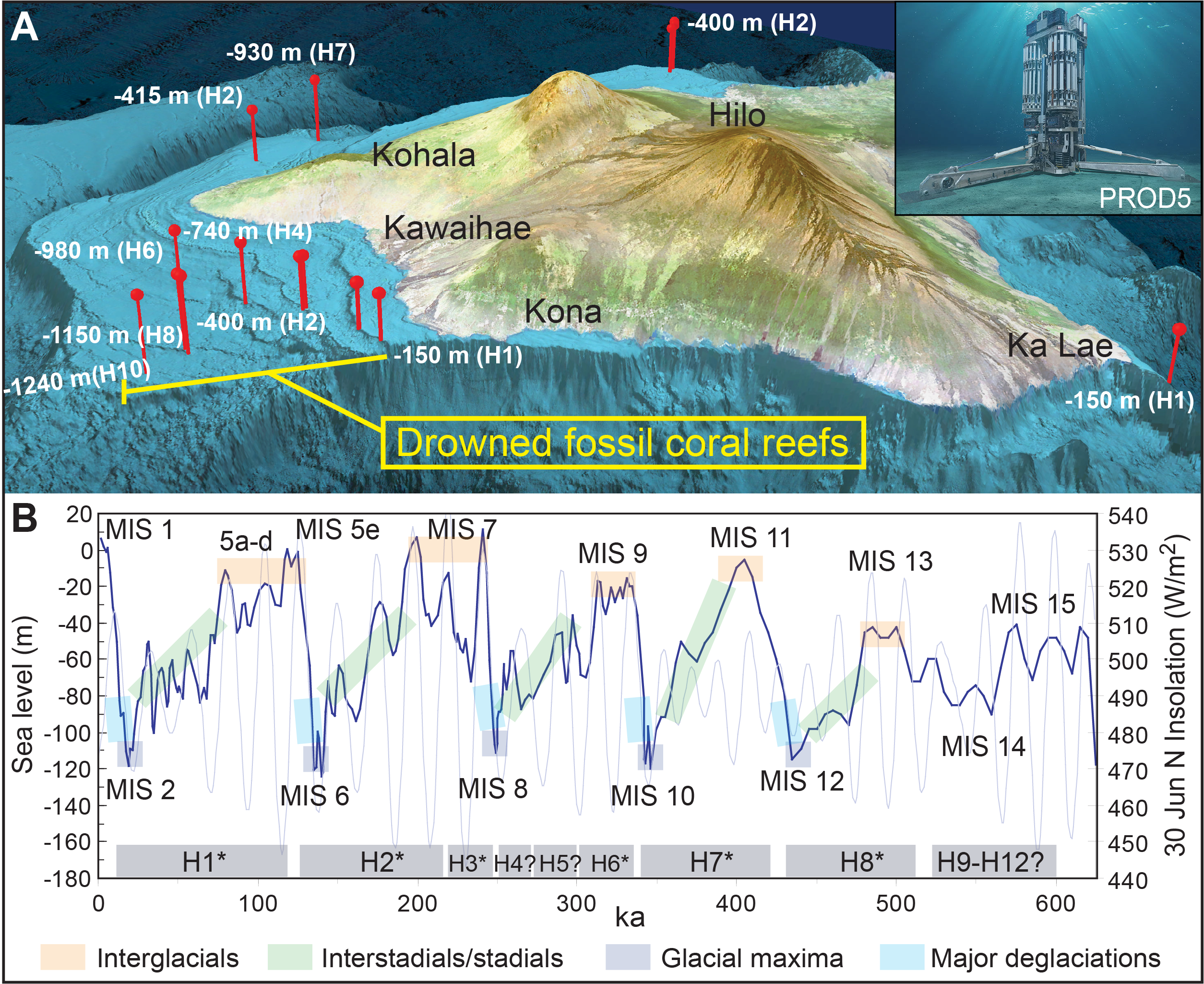
Figure F2. Reefs drilled and regional history.
2.3. Reef terraces: distribution, morphology, and age data
Based on compiled bathymetric data sets (Figure F3) (MBARI Mapping Team, 2000; Smith et al., 2002), we identified 13 major (designated H0–H12 from shallowest to deepest [H is for Hawai’i]) and 9 minor reef terraces (designated with suffixes a, b, c, etc.) around Hawai’i and initially selected 11 primary and 9 alternate drilling targets (Figures F4, F5, F6, F7). In many cases, the seaward edge of a continuous terrace varies in depth laterally because of variable subsidence that produces tilting and retreat of the terrace edge by erosional processes. Detailed summaries of the published reef terrace distribution, morphology, and age data are found in Webster et al. (2009), Puga-Bernabéu et al. (2016), Sanborn et al. (2017), and Taylor (2019). Here, we provide a summary of the site survey data and site selection process.
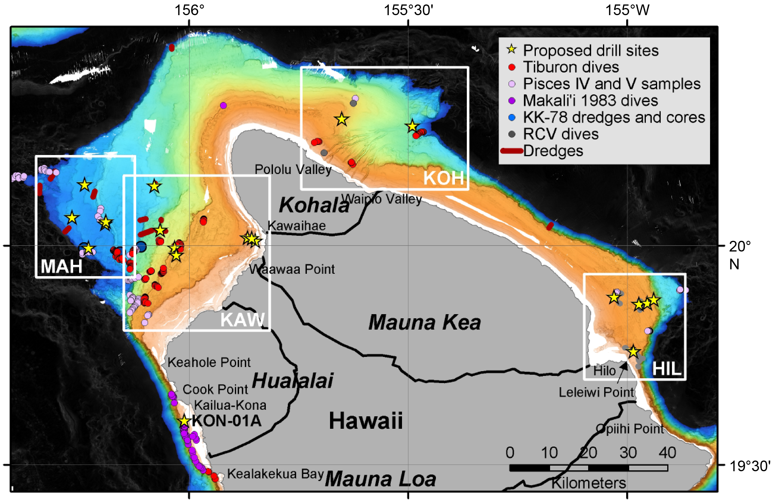
Figure F3. Proposed Expedition 389 drill sites and site survey data.
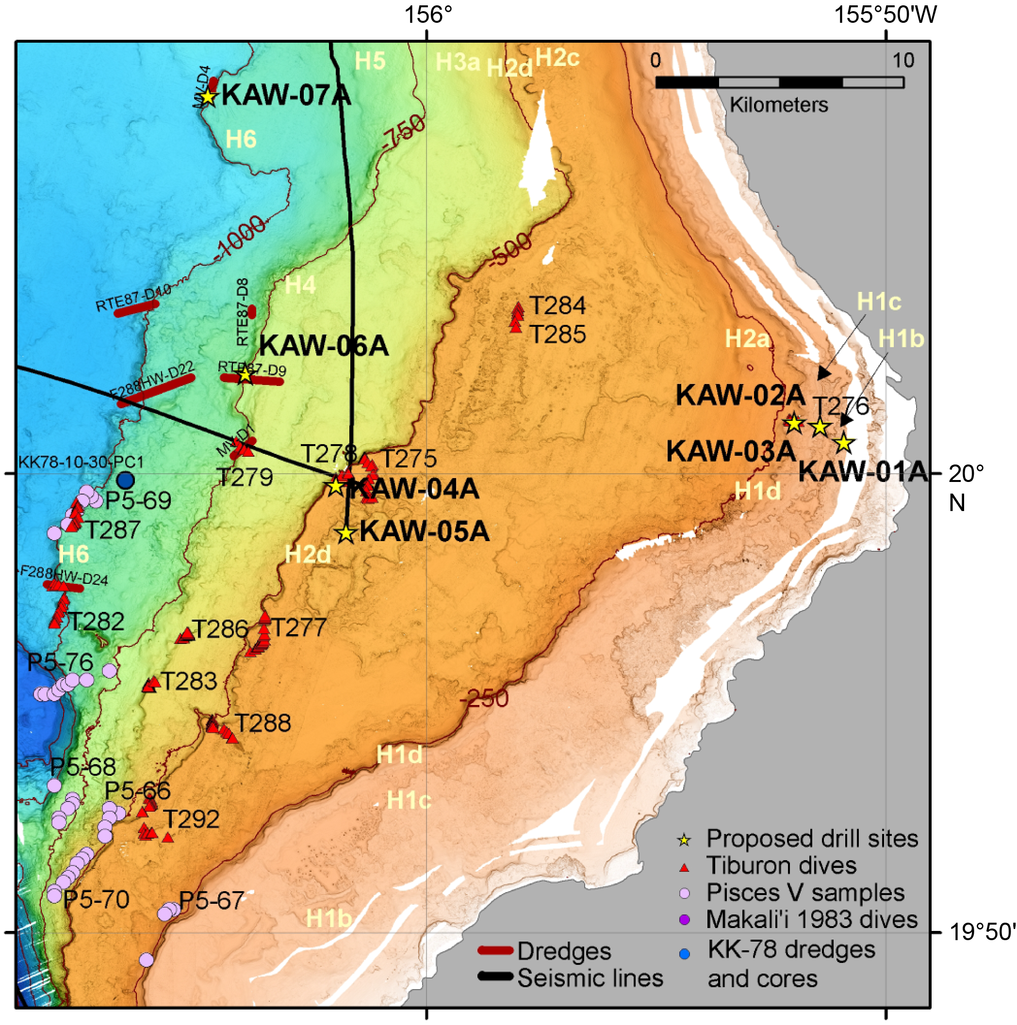
Figure F4. Kawaihae region.
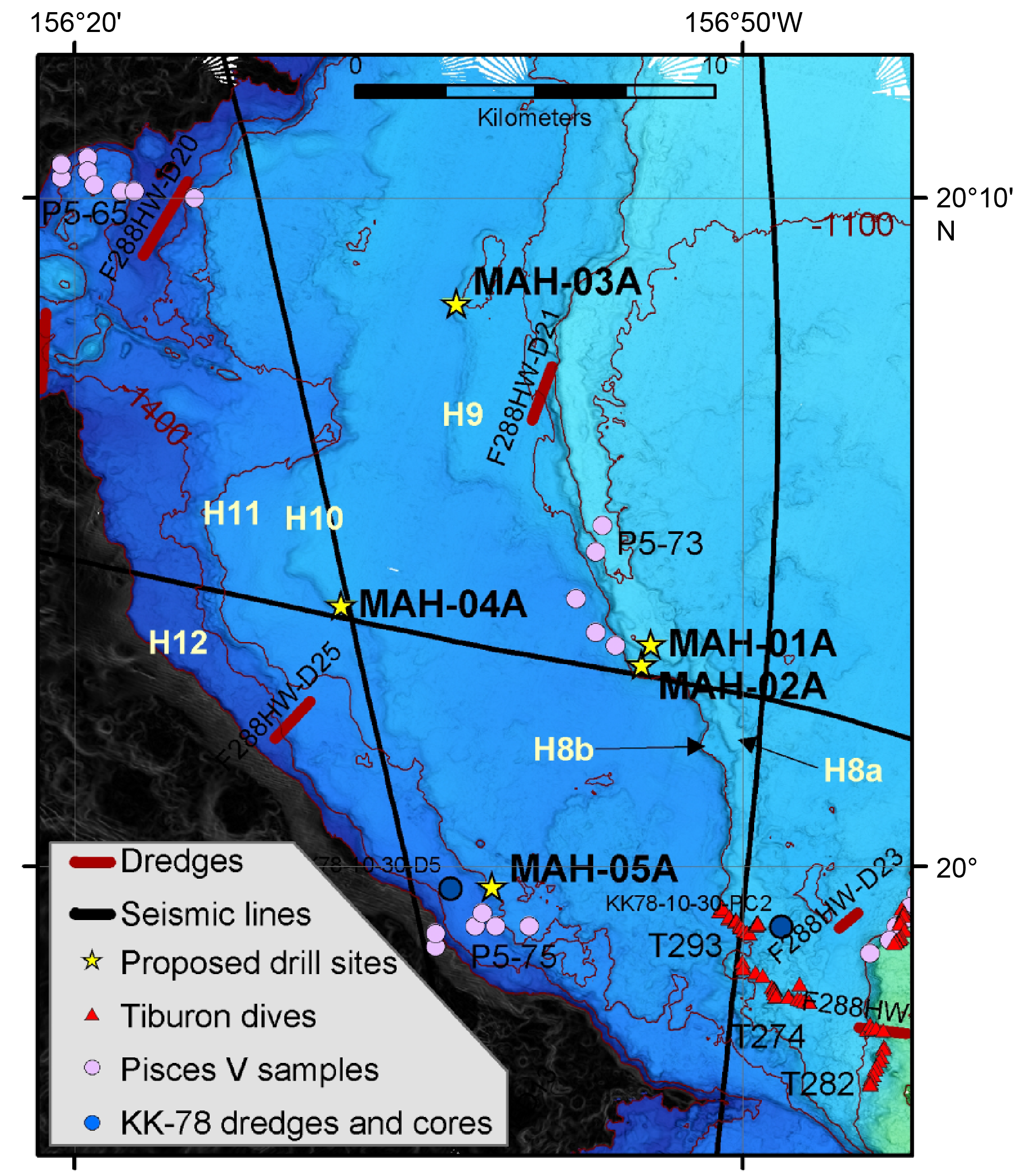
Figure F5. Mahukona region.
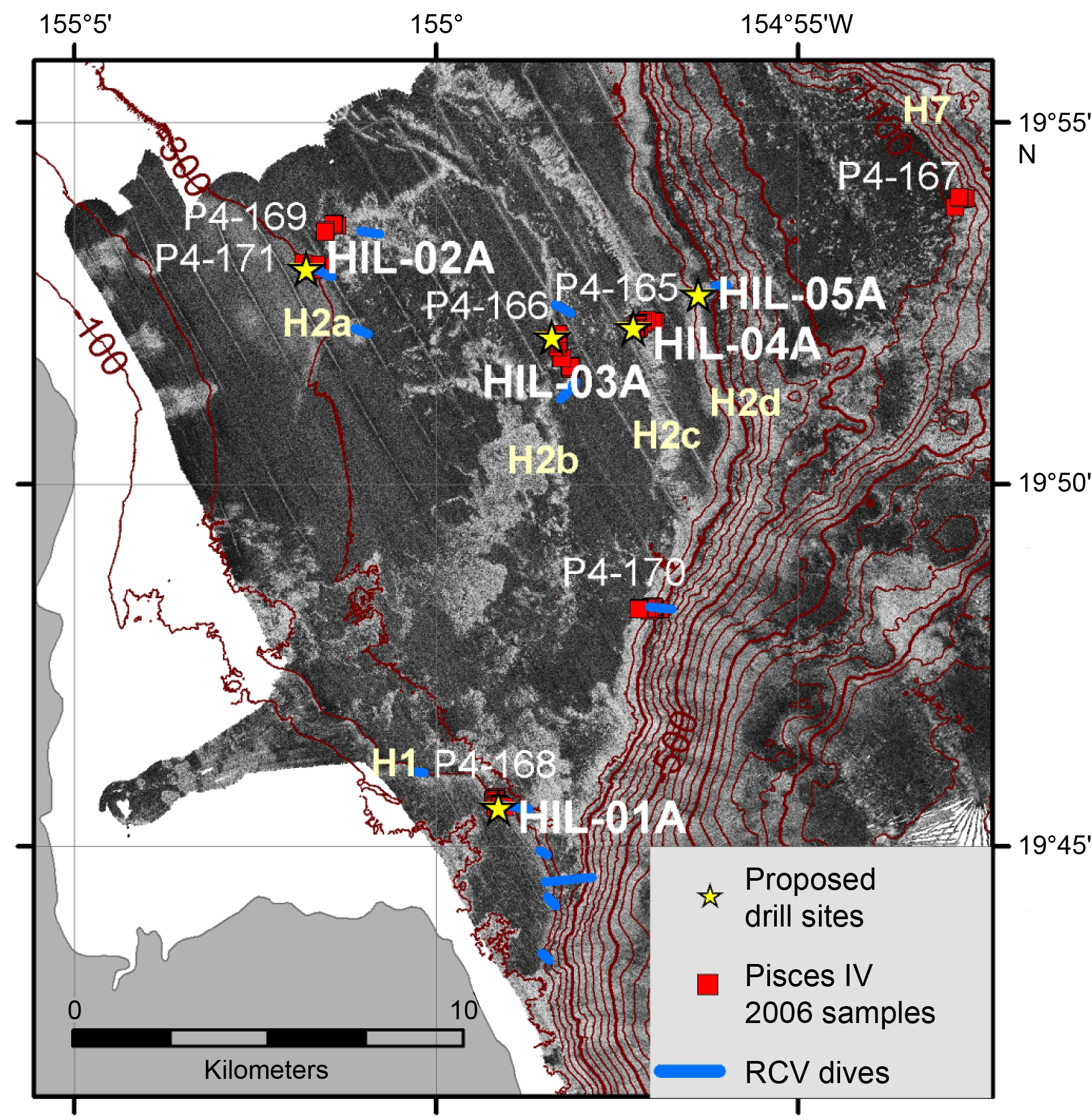
Figure F6. Hilo region.
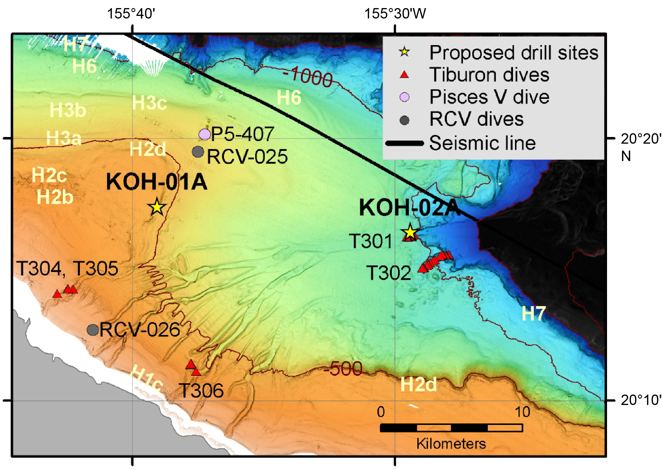
Figure F7. Kohala region.
2.4. Site survey data
The assembled site survey data set used to select the drilling sites represents work by many institutions and researchers over the last 40 y. High-resolution swath bathymetry and backscatter, in combination with ROV/submersible and dredge data from proposed drilling locations or adjacent locations, were the primary data sets used to define the extent and characteristics of the fossil reefs and select the proposed drill sites (Figures F4, F5, F6, F7) (Webster et al., 2023). Swath bathymetric data were systematically collected in 1998 with a 30 kHz Simrad EM300 system by the Monterey Bay Aquarium Research Institute (MBARI) on the Kohala Terrace (named by Campbell, 1986) and the northeast margin of Kohala Volcano (Clague et al., 1998; MBARI Mapping Team, 2000) and by the United States Geological Survey (USGS) off shore Hilo (Dartnell and Gardner, 1999). These data have much higher resolution and superior navigation to all previous surveys and form the primary data used for site selection. Both 30 kHz data and Sea-Beam swath bathymetry were collected during a series of cruises by the Japan Agency for Marine-Earth Science and Technology (JAMSTEC) starting in 1998 (Smith et al., 2002). Additional swath data has been collected by the University of Hawai’i and the National Oceanic and Atmospheric Administration (NOAA) Mapping Group. All data were used to define the extent and characteristics of the reefs and select drill sites. Several air gun lines crossing the terraces were collected during the GLORIA surveys (USGS Cruise F6-86-HW) in 1986.
A great deal of work has already been done to sample and observe the reefs around Hawai’i, starting in 1983 with Makali’i submersible dives (M288–M298) (Figure F5), mainly on Reef H1d but also one dive on Reef H2c off Kohala (Dive M287) (Figure F7). In 1985, Pisces V submersible dives (P5-65 through P5-78) explored and sampled many of the reefs off the Kona coast. Dredging programs were undertaken from the R/V Melville in 1987 (RTE87-D7 through RTE87-D9) and 2005 (TUIM-MV-D1 through TUIM-MV-D4) and from the R/V Farnella in 1988 (F2-88-HW-D18 through F2-88-HW-D25) and 1991 (F2-91-HW-D2) on the northeast Reef H2d on Mauna Kea. One additional Pisces V dive (P5-407) and two ROV dives (RCV25 and RCV26) in 1999 took place on the terraces east of Kohala (Figure F7). A total of 7 Pisces IV dives (P4-165 through P5-171) and video transects during 13 RCV-150 ROV dives (RCV334–RCV346) were conducted on the reefs off shore Hilo (Figure F6). The Hawai’i Undersea Research Laboratory has also conducted at least 100 additional submersible dives and ROV video transects on these reefs for fishery and other biological studies. In total, over 550 samples of reef carbonate collected during these operations have been examined (Webster et al., 2009; Puga-Bernabéu et al., 2016; Sanborn et al., 2017).
In 2001, MBARI’s ROV Tiburon completed 14 dives on the reefs southwest of Kohala (T275–T279, T282–TT288, and T291–T293) and 5 dives on the reefs and canyons east of Kohala (T301, T302, and T304–T306) (Figure F7). One of these dives (T301) provided observations of the reef interior with successive reef packages that likely represents the reef initiation, complex growth, and drowning of the H7 reef. At this location exposed by submarine channel erosion, ROV sampling at the base and top of this section, combined with detailed video observations, reveals at least six distinct reef units. These are characterized by different volumes of in situ coral colonies and variations in framework types that are separated in places by planar surfaces, perhaps representing thick coralline algal crusts and/or subaerial exposure surfaces. U-series dating of two coral samples from near the base of this reef yield ages of 377–392 ka (Webster et al., 2009), indicating this reef likely grew during Marine Isotope Stages (MISs) 10 and 11 (Figure F8).
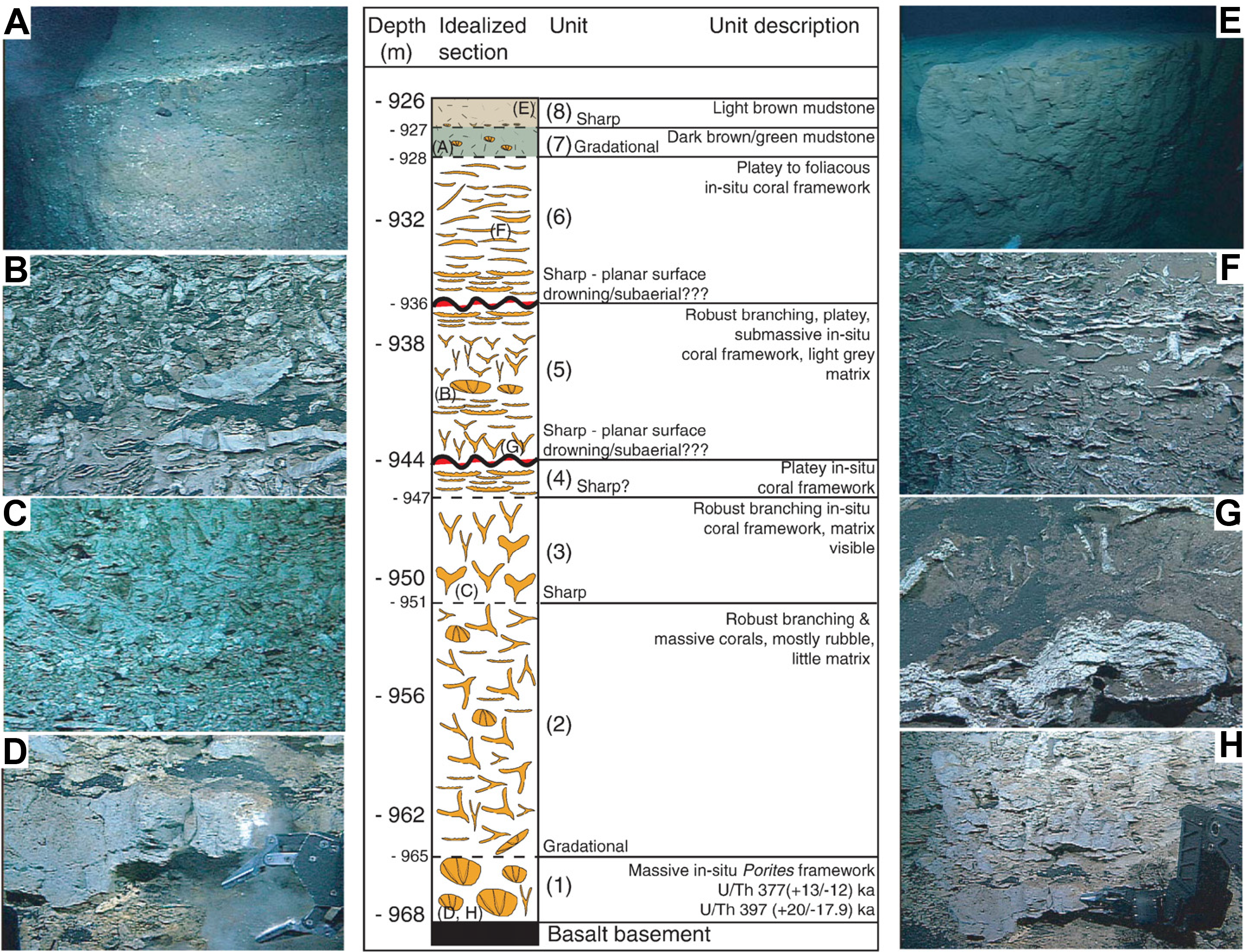
Figure F8. Stratigraphic section.
3. Scientific objectives
The scientific objectives for Expedition 389 directly address key IODP strategic objectives to investigate the mechanisms that control rapid climate change and the relationship between changes in mean climate state and high-frequency (seasonal–decadal) climate variability. Specifically, it is directly aligned with the Earth’s Climate System, Feedbacks in the Earth System, and Tipping Points in Earth’s History Objectives of the IODP 2050 Science Framework. The specific objectives of the project are discussed below.
3.1. Objective 1: to define the nature of sea level change in the central Pacific over the last 500 ky
We aim to reconstruct the most complete and detailed sea level record from fossil corals, particularly into, during, and out of the glacial periods. These data will allow more detailed testing of the sensitivity and vulnerability of ice sheet responses to climate change on orbital to millennial timescales. A sea level curve will be built using absolute radiometric dating methods (14C accelerator mass spectrometry [AMS] <50 ka and U/Th) of in situ corals and coralline algae, paleobathymetric data, and published and directly calculated subsidence rates for Hawai’i.
3.2. Objective 2: to reconstruct paleoclimate variability for the last 500 ky and establish the relationship between the mean climate state and seasonal–interannual variability
We aim to use coral-derived temperature and precipitation records to investigate how high-latitude climate (e.g., ice sheet size), atmospheric CO2 levels, and mean and seasonal solar radiation impact Hawaiian climate, including storminess and the position of the Intertropical Convergence Zone. In combination with theoretical studies of subtropical climate change, these records will allow for the identification and study of critical processes that determine Pacific-wide climate.
3.3. Objective 3: to establish the geologic and biological response of coral reef systems to abrupt sea level and climate changes
We aim to reconstruct the detailed stratigraphic, geomorphic, paleoecological, and paleoenvironmental evolution of each reef in response to abrupt sea level and climate changes; test ecological theories about coral reef resilience and vulnerability to past and future climate changes by assessing the nature and rate of change in reef communities within and between successive reefs over interglacial–millennial timescales; and establish the nature of living and ancient microbial communities in the reefs and their role in reef building.
3.4. Objective 4: to elucidate the subsidence and volcanic history of Hawai’i
We aim to refine the reconstruction of the spatially and temporally varying subsidence of Hawai’i and to contribute to understanding the volcanic evolution of the island. The key to these objectives is to obtain well-dated volcanic samples from the base of each hole and from interbeds within or draping over the coral reefs.
4. Operational strategy
4.1. Site selection and locations
A total of 11 primary sites and 9 alternate sites were originally selected (Figures F3, F4, F5, F6, F7), located in water depths ranging approximately 129–1234 meters below sea level (mbsl) with intended maximum penetration depths of ≤110 meters below seafloor (mbsf). Although most of the original primary and some alternate sites were drilled during Expedition 389, the site selection and drilling strategy changed after the expedition was underway because of three main factors. First, PROD5, the seabed drilling system, was unable to reach the planned penetration depths at all but one site. Thus, the strategy was adjusted to drill more shallow penetration holes (20–40 mbsf) at several sites. Additionally, IODP Environmental Protection and Safety Panel (EPSP) and European Consortium for Ocean Research Drilling (ECORD) Facility Board (EFB) approval was obtained to drill a new site during the expedition (Site M0107). Second, because of the lack of sufficient Hawaiian community engagement, Expedition 389 was denied permission to operate in state waters and at three of the primary science-critical sites (in the Kawaihae, Kona, and Hilo regions) located on the H1 terrace could not be drilled. As a consequence, IODP panel approval was obtained during the expedition to drill new sites (M0099, M0106, and M0110) on the H1 terrace outside of state waters, even though they are not ideally located to meet some important scientific objectives. Third, based on observations of reef material recovered early during the expedition at Site M0097, it appeared promising to move drill sites closer to the seaward edge of the terrace with the expectation that this would result in recovery of more submassive and massive fossil corals. Although the 150 m radius of each site target allowed for this flexibility at most sites, this was not the case at proposed Site MAH-02A (Figure F7); thus, IODP panel approval was obtained during the expedition to drill a new site (M0108) located on the same terrace ~200 m south of Site MAH-02A. Expedition 389 sites (Figure F9; Table T1) thus focus on five regions around the island of Hawai’i: Kawaihae (Figure F10), Mahukona (Figure F11), Kohala (Figure F12), Hilo (Figure F13), and Ka Lae (Figure F14).
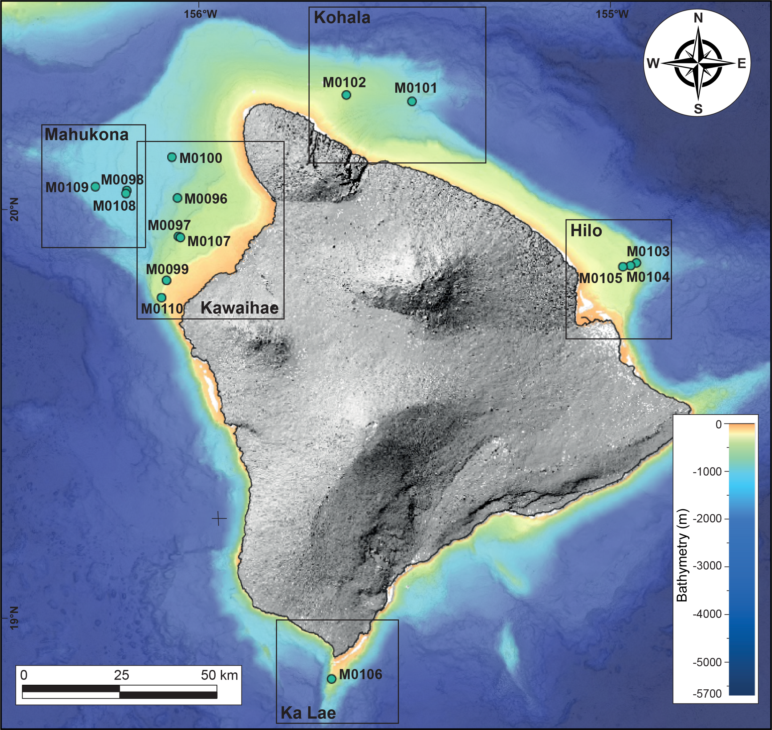
Figure F9. Final site locations.
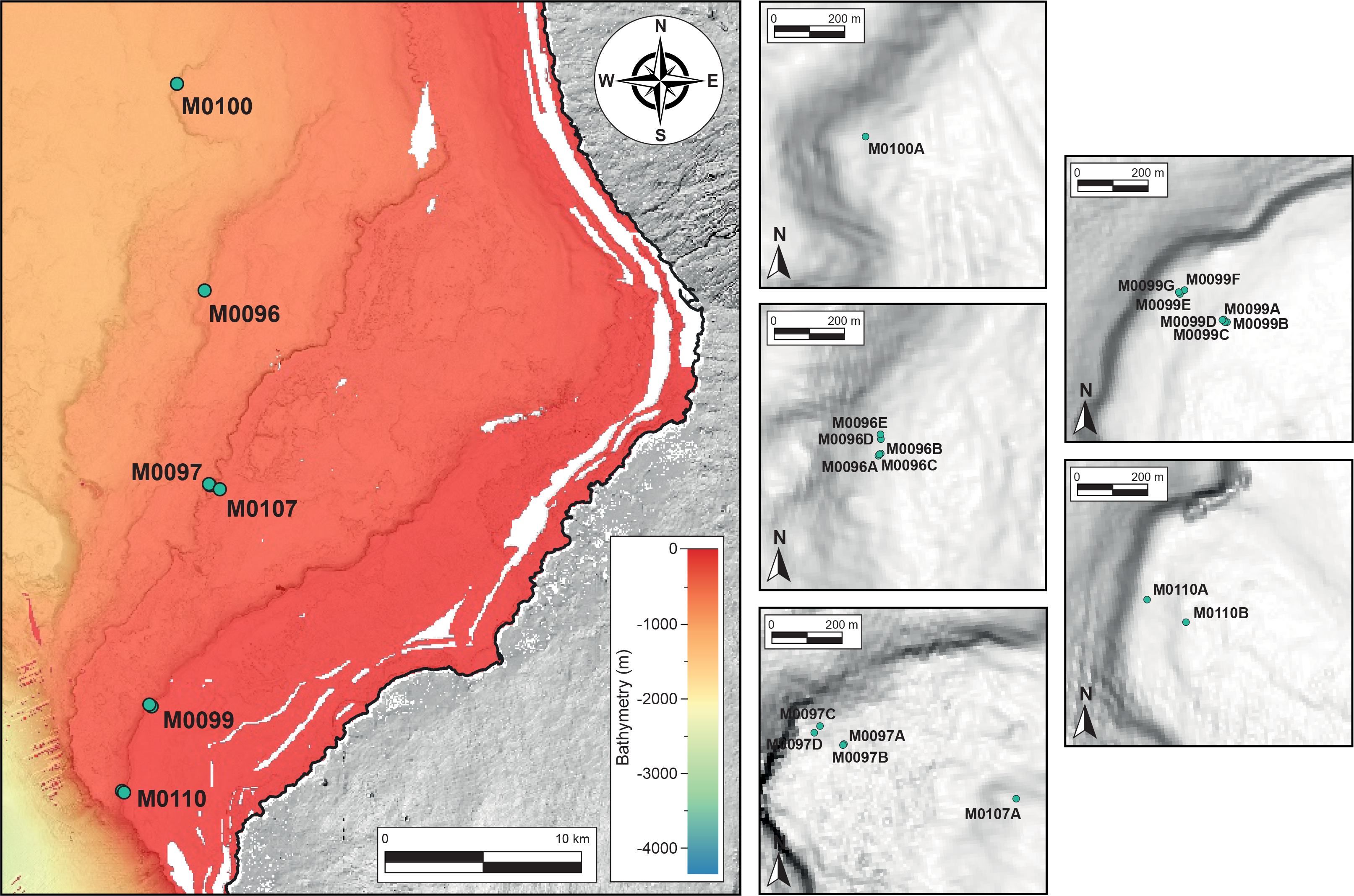
Figure F10. Kawaihae region site locations.
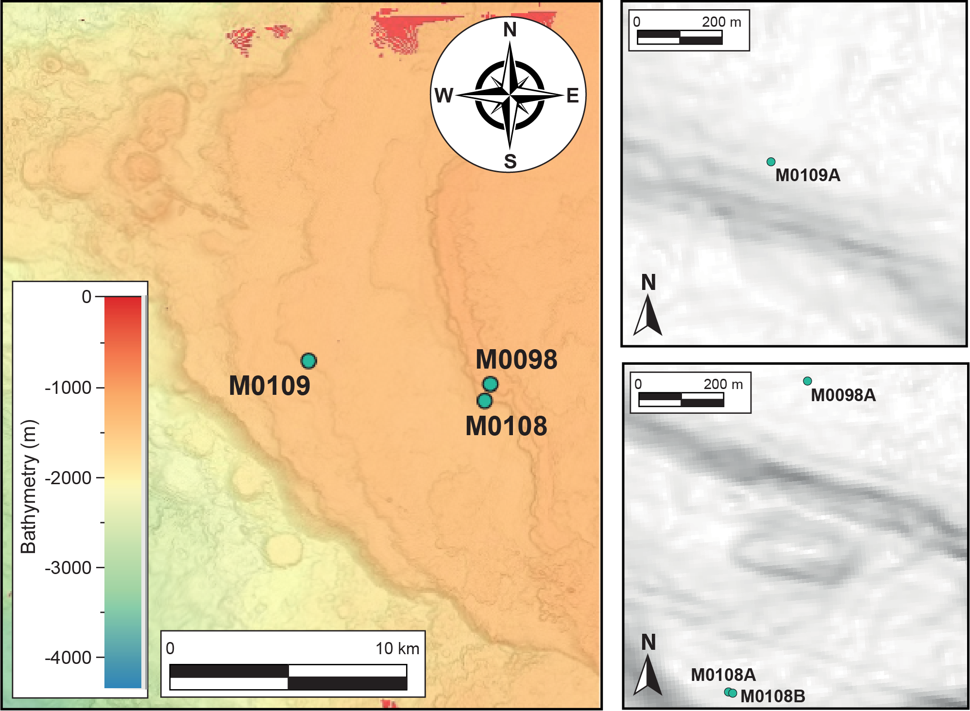
Figure F11. Mahukona region site locations.
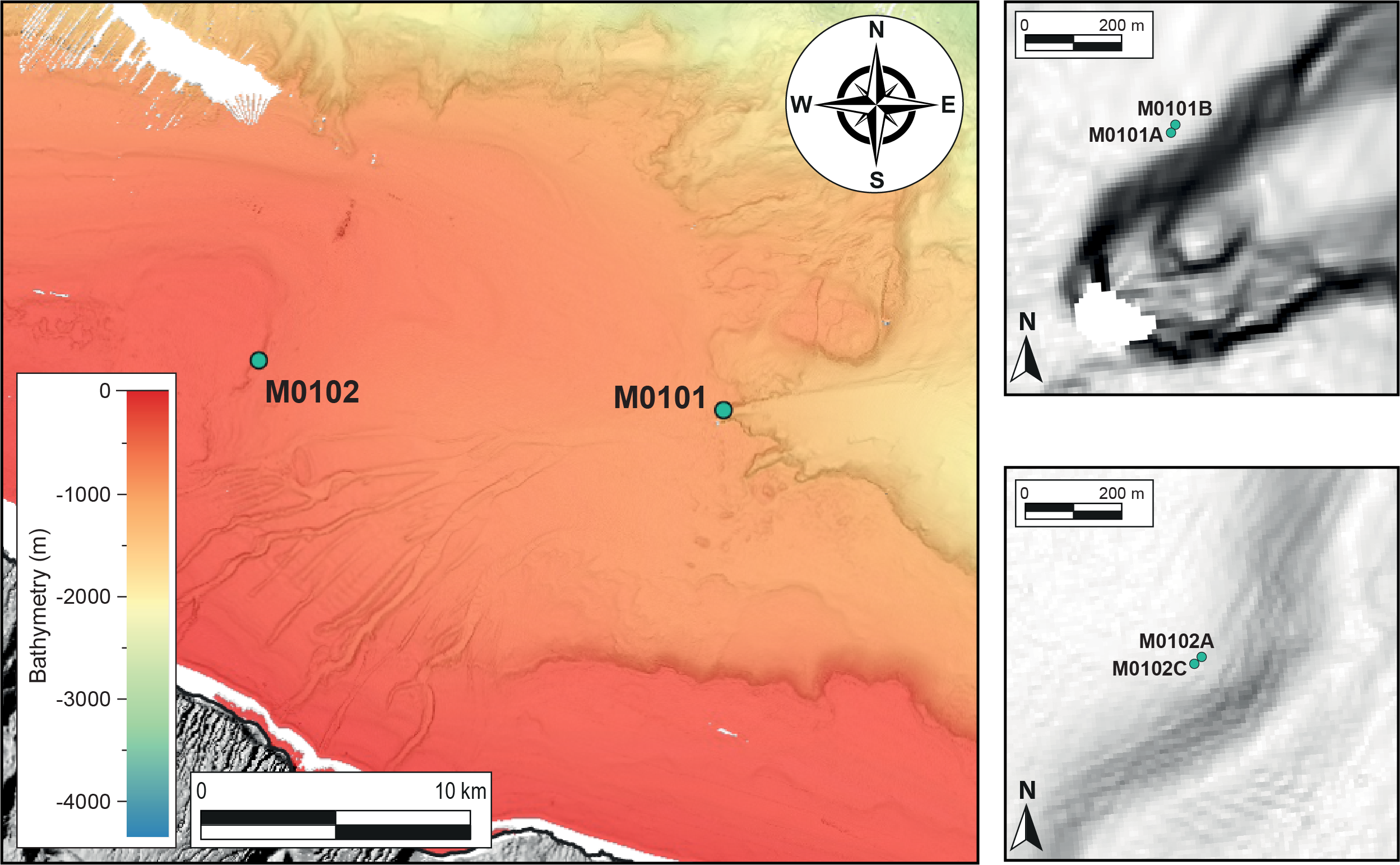
Figure F12. Kohala region site locations.
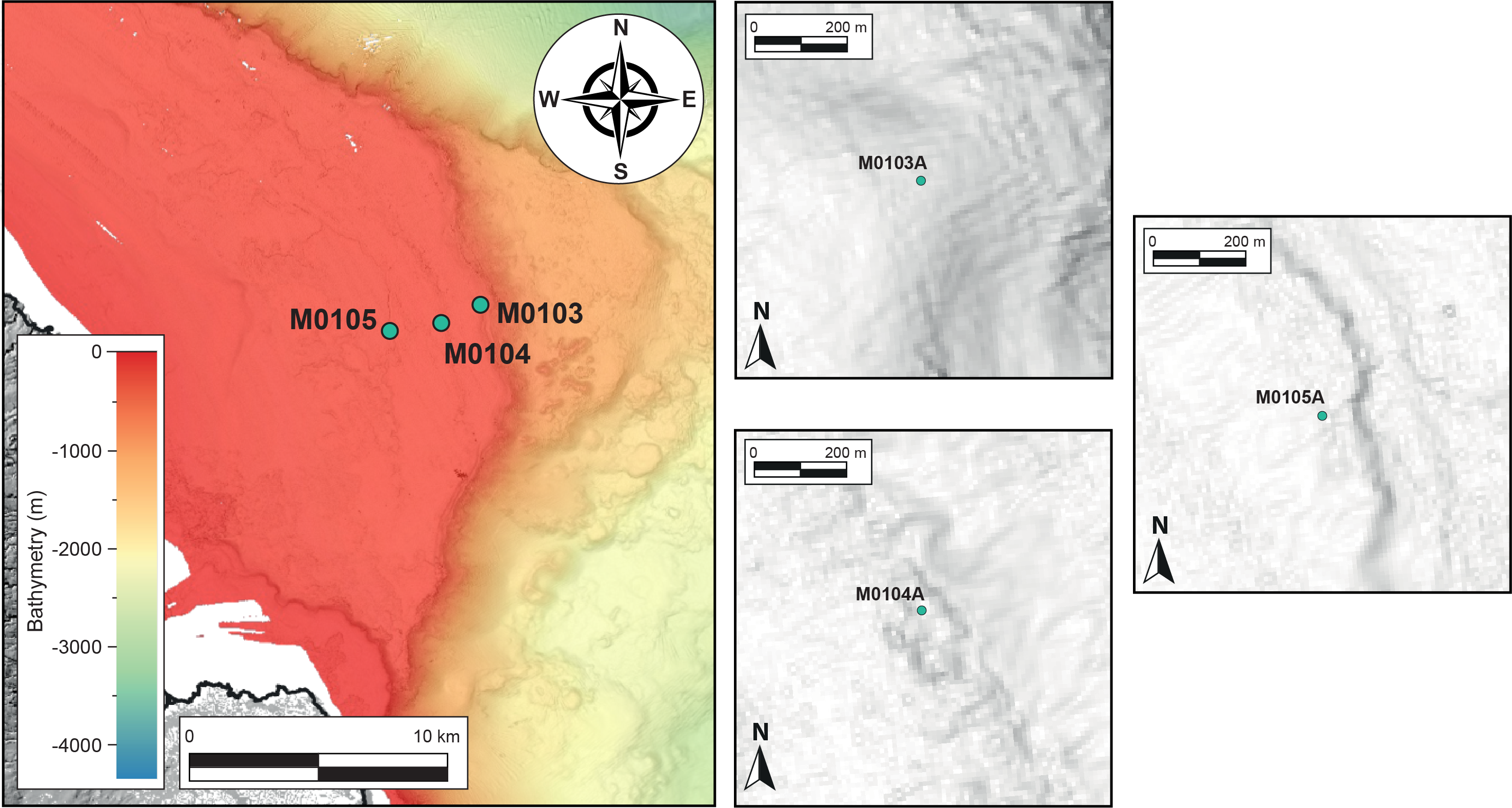
Figure F13. Hilo region site locations.
Figure F14. Ka Lae region.
5. Operations
5.1. Offshore phase
The drilling platform used for Expedition 389 was the dynamically positioned multipurpose vessel MMA Valour (84 m long; 4258 tons), operated by MMA Offshore. A suite of containerized laboratories and offices were installed on the aft deck area. Coring operations were performed by Benthic’s fifth-generation Portable Remotely Operated Drill (PROD) seafloor drill. PROD5 is rated to a water depth of 4000 m, is unaffected by surface heave conditions, and consequently has good control on bit weight, increasing the likelihood of higher quality cores in shallow waters and challenging lithologies compared to ship-mounted systems that rely on heave compensation.
Rotary coring was the primary drilling method, recovering core with a diameter of 72 mm in 2.75 m sampling barrels. To give some flexibility during rotary coring operations, two different rotary drill bits (diamond surface set and impregnated) were available. One 75 mm diameter push core was attempted at Site M0101, recovering 6 cm of soft sediment from Hole M0101A (Core 1P-1). A small number of wash bores were typically loaded to allow for advancement without coring or to clean the borehole of material that may have fallen to the bottom during core runs or setting casing. Two core liner types were available: aluminum and polycarbonate. If an aluminum core liner was used, cores were transferred to polycarbonate liners during the offshore curatorial process.
PROD5 is self-contained with its own Launch and Recovery System (LARS), occupying a basic deck footprint of 17.0 m × 8.0 m, and is lowered to the seafloor on an umbilical cable. The computerized control system allows PROD5 to safely position on the seabed by moving above the sea bed using its onboard thruster and subsea cameras to ensure there are no obstacles and/or significant macro benthos on the selected landing site. Each of PROD5’s three legs can be independently adjusted to provide a level platform from which to deploy the core barrels. Upon confirmation of a successful landing on site, the sound velocity profile gathered during deployment to the seafloor was integrated to the ultra-short baseline (USBL) method as part of the process to determine the coordinates of the center of gravity of PROD5. This method takes into account sound velocity error, offset measurement, and pitch and roll corrections. Using the coordinates of the ship as a reference, the latitude and longitude of the hole was calculated with an error of up to 1% of the water depth.
Mobilization of the vessel took place in Barbers Point Harbor, Kapolei, on the island of O’ahu between 26 and 31 August 2023. ECORD Science Operator (ESO) staff boarded on 26 August, and the offshore science party participants joined on 29 August. The MMA Valour set sail at 1750 h on 31 August, and the first leg of the offshore phase of the expedition continued to 1000 h on 27 September (Table T1), when the MMA Valour began transit back to Kapolei, arriving at 0630 h on 28 September for a ~25 h midexpedition port call for a crew and technician change, to load supplies, to send samples to onshore laboratories for geochronological analysis, and to offload the reefer of core collected during Leg 1. Leg 2 began at 0700 h on 29 September, when the vessel began transiting to Site M0100. It arrived on location at 0230 h on 30 September.
The offshore operational phase of Expedition 389 concluded at 2345 h on 31 October with the transit back to Kapolei for demobilization. The MMA Valour arrived at port after 0600 h on 2 November, and the offshore scientists disembarked in the early afternoon. The remaining ESO containers and the second refrigerated core reefer containing Leg 2 cores, core catcher samples, and interstitial water splits were offloaded during demobilization for return shipping to final destinations. ESO staff disembarked the vessel on 4 November at the end of Expedition 389 demobilization.
In total, 44.32 days of Expedition 389 were spent operational on station, 1.76 days were spent in transit between sites or from port, 1.0 days were spent in port during the expedition, 14 h were spent on standby at station because of vessel technical issues, 10.94 days were spent on equipment-related downtime, and 2.0 h in a diversion to port for disembarkment of a contractor for medical reasons.
As with the majority of IODP Mission Specific Platform expeditions, no cores were split during the offshore phase; therefore, a comprehensive onshore phase (the Onshore Science Party [OSP]) at the IODP Bremen Core Repository (BCR) complemented the offshore phase. Table T2 summarizes the descriptions and measurements made during Expedition 389 and indicates whether they were conducted off shore or on shore.
5.2. Onshore Science Party
Prior to the OSP, X-ray computed tomography (CT) scanning for Expedition 389 was conducted on the whole cores at the Core Scanning Facility at the British Geological Survey in Keyworth, United Kingdom. The refrigerated core reefers were shipped from Hawai’i to the United Kingdom and were delivered in two shipments to the Core Scanning Facility, arriving on 2 January and 7 February 2024. Following X-ray CT scanning, the core was then shipped to the BCR in four shipments for processing during the OSP, which took place 6–26 February 2024 at the BCR located in the Center for Marine Environmental Sciences (MARUM) building on the campus of Bremen University, Germany. The cores were split and described in detail, and IODP standard sampling and measurements and postexpedition scientific research sampling were undertaken (Table T2).
Further analytical laboratories were accessed at the Department of Geosciences (geochemistry, paleomagnetism, and X-ray diffraction mineralogy) and at MARUM (physical properties and nondestructive core logging) at Bremen University (Table T2). In addition to the IODP standard suite of analyses performed during the OSP, hyperspectral data were acquired on all archive halves using a SisuROCK drill-core scanner (Spectral Imaging Ltd. [Oulu, Finland]) to provide information on carbonate mineralogy and diagenetic alteration.
6. Lithologic facies
The combination of the overall lithology, major and minor components, and sedimentary boundaries show the fossil reefs around Hawai’i are composed of 12 major lithologic facies plus fall-in material (Figure F15), defined as follows:
Figure F15. Lithologic facies.
- Fall-in material (F0): these deposits are reworked, brecciated material, possibly with recoring marks on some debris at the top of the core, different from the facies below.
- Coralgal boundstone (F1): these deposits are mainly built (bound) by corals and encrusting coralline algae forming well-developed frameworks. Vermetids and the encrusting foraminifera Homotrema are present within coralline algal crusts.
- Coralgal-microbialite boundstone (F2): these deposits are formed by coral and coralline algae frameworks either capped by microbialite crusts or with large cavities filled with microbialites. Some gastropods, echinoid spines, serpulid tubes, bivalves, vermetids, and Homotrema are present.
- Microbialite boundstone (F3): these deposits are built mainly by microbialite boundstone with rare occurrences of corals and coralline algae crusts.
- Microbialite-algal boundstone (F3.5): these deposits are characterized by microbialite and algal crusts forming well-developed boundstones.
- Algal boundstone (F4): massive coralline algal crusts forming well-developed frameworks, commonly associated with Homotrema and vermetids and with rare thin corals.
- Consolidated biodetrital sediment (F5): these deposits are biodetrital rudstones, grainstones or packstones with coral clasts, algal clasts, and various accessory bioclasts (bivalves, gastropods, echinoid spines, and large benthic foraminifers [LBFs]).
- Unconsolidated biodetrital sediment (F6): these deposits are biodetrital carbonate sands to gravels with coral clasts, algal clasts, LBFs, gastropods, Halimeda clasts, and echinoid spines.
- Hemipelagic/pelagic sediment (F7, no image): these mudstones/wackestones are dominated by planktonic foraminifers, mollusks, small benthic foraminifers, abundant micrite, and minor volcaniclastic grains.
- Volcaniclastic sediment (F8): these deposits are mostly volcaniclastic sediments, with rare coral clasts as well as LBFs.
- Basaltic volcanic rock (F9): this facies is characterized by a diverse suite of massive, variably vesicular, variably crystal-rich variably fresh/altered, and brecciated basaltic lava rock types with less common pyroclastic types (e.g., hyaloclastite).
- Mixed carbonate-volcaniclastic (F10): these deposits are a mixture of bioclastic carbonate and volcaniclastic sediments, consolidated or not, containing carbonate clasts of corals, algal clasts, Halimeda plates, echinoid spines, gastropods, and LBFs.
- Rhodoliths rudstone/floatstone (F11): these deposits consist of rhodolith accumulations, sometimes embedded in biodetrital sediments, unconsolidated or not. When consolidated, textures are either rudstone or floatstone.
7. Site summaries
7.1. Leeward side
The northwest flank of Hawai’i represents the area of most intensive investigation over the last 40 y. Complete high-resolution bathymetry and backscatter data coverage, combined with extensive ROV and submersible observations and sampling, has revealed a succession of 12 well-developed reef terraces. This area is divided into the proximal drill sites off shore, hereafter referred to as the Kawaihae region (Figure F10), and the more distal drill sites off shore the western flank of the submerged Mahukona Volcano (Clague and Moore, 1991; Moore and Clague, 1992), hereafter referred to as the Mahukona region (Figure F11).
7.1.1. Kawaihae sites
The original sites on this H1 reef were located in Hawaiian state waters, so they were unavailable for drilling (proposed Sites KAW-01-3B, KON-01A, and HIL-01A) (Figures F3, F4, F6). Sites M0099 and M0110 were selected and drilled because they intersect the major 150 mbsl reef terrace (H1d) that can be traced from the originally proposed sites and occur around much of the flanks of the island of Hawai’i (Moore and Fornari, 1984; Webster et al., 2004a). They were drilled between 132 and 157 mbsl. ROV observations and samples at these sites confirm their reefal nature. This terrace drowned about 14.7 ka (Webster et al., 2004a; Sanborn et al., 2017) and likely grew during MISs 1–5 (Webster et al., 2009).
The 400 mbsl terrace forms a well-developed and continuous reef (H2d) off Kawaihae. This reef has been extensively sampled and observed by submersible, and U/Th ages on corals range 133 to approximately 170 ka (Webster et al., 2009). A series of holes (414–424 mbsl) were drilled at Site M0097 at the seaward edge of the prominent terrace feature, and Site M0107 was drilled on a shallower subterrace at 404 mbsl. Sites M0096 and M0100 were drilled to recover reefal material from deeper terraces off shore Kawaihae. However, Site M0096, located on the H4 terrace at approximately 740 mbsl, and Site M0100, located on the H6 terrace at approximately 990 mbsl, were only drilled to <15 mbsf and comprise primarily lava.
7.1.1.1. Site M0096
Site M0096 consists of four holes (M0096A, M0096C, M0096D, and M0096F) located on a terrace at 736 to 741 mbsl (Figures F10, F16) (see Operations in the Site M0096 chapter [Webster et al., 2025b]). The first three holes primarily comprise mixed carbonate-volcaniclastic sediments, bioclastic materials (including corals and coralline algae), and large, subangular to subrounded volcanic clasts of variable crystallinity. In-place lava was recovered at the base of Hole M0096D. Hole M0096F consists entirely of in-place lava flows with variable vesicularity and low crystallinity lava, and lava clinker is common in subaerial emplacement conditions.
Figure F16. Kawaihae region cores and recovery.
Multisensor core logger (MSCL) and other MSCL physical properties measurements indicate some variability within the in-place lava interval, but there are no apparent downhole trends.
One coral near the top of Hole M0096D was dated to 241.4 ± 0.1 ky BP. The date is consistent with the estimated age of the H4 terrace spanning MIS 8/9 (Ludwig et al., 1991; Webster et al., 2009).
7.1.1.2. Site M0097
Site M0097 consists of four holes located on a terrace at 414–424 mbsl (see Operations in the Site M0097 chapter [Webster et al., 2025c]). Holes M0097A and M0097B were drilled at 414 mbsl, and Holes M0097C and M0097D were drilled closer to the edge of the terrace in slightly deeper water at 424 mbsl. For all four holes at Site M0097 (Figures F10, F16), the top of the succession is a mixed carbonate-volcaniclastic coarse-grained deposit up to 1.81 m thick. Below, coralgal-microbialite boundstone with dominantly branching and columnar Porites extends down to about 13.00 mbsf (Holes M0097A and M0097D) and to 19.00 mbsf (Hole M0097C). Farther downhole, intervals of algal and microbialite-algal boundstone comprise thick coralline algal crusts and few corals, mainly branching Porites, to about 20.00 mbsf (Hole M0097A), 24.00 mbsf (Hole M0097D) and 30.00 mbsf (Hole M0097C). Below, coralgal-microbialite boundstone was recovered to 58.42 mbsf (Hole M0097A); columnar Porites dominate in the upper part of this interval, and branching Porites are dominant in the lower.
MSCL and other physical properties data indicate some variability likely related to variations in lithology, but there are no notable features and no apparent downhole trends.
A total of seven U-Th dates were measured on samples from Site M0097; three of these samples are rejected based on anomalous δ234U initial values or anomalously high 238U concentrations. Of the remaining four samples, the dates span ~133–150 ky BP with no stratigraphic age inversions, although the date at the base of Hole M0097B indicates some stratigraphic inconsistency. However, broadly these dates are consistent with the interpretation of the MIS 6/7 age of this H2 terrace from prior studies (Webster et al., 2009).
7.1.1.3. Site M0099
Site M0099 consists of two subterraces, one at ~132 mbsl and another at ~147 mbsl (Figures F10, F16) (see Operations in the Site M0099 chapter [Webster et al., 2025]). Holes M0099A–M0099C are located on the shallower subterrace and are directly correlatable. Based on the main facies changes, discontinuity surfaces, and/or changes in physical properties, three main lithostratigraphic intervals are identified. The first interval forms the uppermost 6 to 7 m of each hole. The basal boundary of the first interval is a hardened, blackened, and bioeroded surface in Hole M0099A that corresponds to a major lithologic change in the two other holes. This interval is composed primarily of coralgal-microbialite boundstone in Holes M0099A and M0099C but is dominated by microbialite-algal boundstone in Hole M0099B. The second interval, only present in Hole M0099C (7.05–21.60 mbsf) is dominated by microbialite-algal boundstone and is bounded at its base by a major facies change, also reflected in the physical properties data. The third interval, also present only in Hole M0099C (21.60–36.05 mbsf), is bounded at its base by a hardened and bored surface. This interval is divided into two main lithologies: an upper algal boundstone that overlies a coralgal boundstone with a coarse-grained biodetrital matrix.
Holes M0099E–M0099G are located on the lower (144–146 mbsl) subterrace. Four major lithostratigraphic intervals are identified. The first interval forms the uppermost 6 to 7 m of Holes M0099E and M0099F. The basal boundary of this interval is not marked by a distinct sedimentary discontinuity but by a major facies change. This interval is composed of coralgal-microbialite boundstone in Hole M0099E, but two lithologies can be distinguished in Hole M0099F: an algal boundstone in the upper part overlies a coralgal boundstone. The second interval, observed in Holes M0099E (5.86–15.15 mbsf) and M0099F (7.08–12.97 mbsf), is dominated by microbialite-algal boundstone and algal boundstone and is bounded at its base by a major facies change, as well as a sharp change in physical properties. The third interval is present only in Hole M0099E (15.15–31.50 mbsf) and is divided into two main lithologies: an upper coralgal boundstone that overlies an alternation of algal boundstone and unconsolidated, coarse-grained biodetrital sediment. The recovered material from Hole M0099G consists only of the fourth interval (30.89–48.40 mbsf), which is mainly composed of coralgal boundstone and algal boundstone. The contact with the lava substratum defines the basal boundary of this interval. The basaltic lava material in the lower parts of Hole M0099G represents coherent, in-place lava flows, hyaloclastite, and volcanic rubble, much of which is fresh and unaltered, although zones of substantial alteration occur in both the coherent lava and the hyaloclastite. A significantly more phenocryst-rich lithology occurs in the lower sections of Hole M0099G.
The physical properties data, particularly the MSCL natural gamma radiation (NGR) and density data, suggest there is a marked change at around 25 mbsf in Hole M0099C and at around 15 mbsf in Hole M0099E. The NGR values are relatively high and the density values are relatively low below these depths compared to those above. This correlates with major changes in lithologies (i.e., microbialite-algal boundstone to algal boundstone in Hole M0099C and microbialite-algal boundstone to coralgal-microbialite in Hole M0099E). A total of six samples for radiocarbon dates and seven samples for U-Th dates were measured on samples from Site M0099; two of the U-Th dates were rejected based on anomalously high 238U concentrations. The radiocarbon dates and remaining five U-Th dates are in stratigraphic order and are consistent with the interpretation of the age of the H1 terrace spanning MISs 1–5 (Ludwig et al.,1991; Webster et al., 2009; Sanborn et al., 2017).
7.1.1.4. Site M0100
Site M0100 consists of one hole (M0100A) (Figures F10, F16) located at 998 mbsl; it was drilled to 12.43 mbsf (see Operations in the Site M0100 chapter [Webster et al., 2025e]). This hole comprises an upper portion of coralgal boundstone underlain by a volcanic sequence of in-place lavas, welded volcanic breccias, and volcaniclastic sediments.
The MSCL resistivity, density, and magnetic susceptibility data from Hole M0100A vary considerably and may correspond to changes in the physical properties and/or chemistry of the lavas (the overlying carbonates are not covered by those measurements).
One U-Th date was obtained from a sample from Hole M0100A, yielding a date of ~329 ky BP, which is consistent with the estimated MIS 9 age for the H6 terrace (Ludwig et al., 1991; Webster et al., 2009 and references therein).
7.1.1.5. Site M0107
Site M0107 consists of one hole (M0107A) (Figures F10, F16) located at 404 mbsl; it was drilled to 13.05 mbsf (see Operations in the Site M0107 chapter [Webster et al., 2025l]). This site represents a shallower subterrace of the H2 terrace that was also drilled at Site M0097.
Hole M0107A mostly recovered porphyritic lava with high contents of olivine and clinopyroxene in an unaltered microcrystalline matrix disrupted by intervals of biogenic carbonate crusts and bioclastic carbonate sediment infilling. The lava is directly overlain by a thin coralgal boundstone (10 cm thick) that in turn is capped by a conglomerate of mixed carbonate-volcaniclastic clasts.
The MSCL resistivity, density, and magnetic susceptibility data from Hole M0107A have notable variability that may correspond to changes in the physical properties and/or chemistry of the lavas.
One U-Th date was measured on a sample from Hole M0107A, yielding a date of ~130 ky BP. This date is consistent with the estimated MIS 6/7 age of the H2 terrace (Ludwig et al., 1991; Webster et al., 2007).
7.1.1.6. Site M0110
Site M0110 consists of two holes. Hole M0110A is located on the deeper subterrace at 157 mbsl, and Hole M0110B is located on the shallower subterrace at 145 mbsl (Figures F10, F16) (see Operations in the Site M0110 chapter [Webster et al., 2025o]). The cored succession is divided into five lithostratigraphic intervals. From top to bottom, they are: (1) loose rhodoliths, (2) coralgal-microbialite boundstone, (3) biodetrital rudstone, (4) coralgal-microbialite boundstone, and (5) lava. Intervals 1 and 2 are separated from Intervals 3–5 by a major lithologic boundary at 4.37 mbsf in Hole M0110A, and Intervals 3 and 4 are absent in Hole M0110B.
The MSCL NGR, density, and magnetic susceptibility data, as well as the total reflectance index (L*) data, from Holes M0110A and M0110B show notable downhole trends that reflect the transition from reef material above to lava below. Relative to the reef facies, the lava has lower L* and higher NGR, density, and magnetic susceptibility, with notable variability that may correspond to changes in the physical properties and/or chemistry of the lavas.
Four radiocarbon dates were obtained from Site M0110. The uncalibrated radiocarbon dates span ~35–12 ky 14C BP and are consistent with the estimated age of the H1 terrace that spans MISs 1–5 (Sanborn et al., 2017; Webster et al., 2009; Ludwig et al., 1991).
7.1.2. Mahukona sites
Sites M0098 and M0108 are located off shore the submerged Mahukona Volcano and intersect perhaps the most prominent reef structure (H8) on the northwest flank of Hawai’i (Figure F11). This feature is divided into two subterraces; dive observations, samples, and dredges show that these robust features are both coral reefs (H8a and H8b) (Webster et al., 2009). Previous U-series dating of three corals yielded ages of 360, 406, and 475 ka (Ludwig et al., 1991). Site M0098 penetrates the upper reef (H8a) at 1100 mbsl, and Site M0108 penetrates the lower reef (H8b) at 1177 mbsl. At 1242 mbsl, Site M0109 penetrates the deepest (H9) of the reefs sampled during Expedition 389.
7.1.2.1. Site M0098
At Site M0098, one hole was drilled at 1100 mbsl in Subterrace H8a to 19.22 mbsf (Figures F11, F17) (see Operations in the Site M0098 chapter [Webster et al., 2025d]). Based on the main lithologic changes and discontinuity surfaces, four main lithostratigraphic intervals are identified. Interval 1 (0–0.35 mbsf) consists of coralgal boundstone and is bounded at its base by a major facies change. Interval 2 consists of unconsolidated bioclastic carbonate sediments and coralgal boundstone from 0.35 to 1.97 mbsf. This interval is bounded at its base by a major facies change. Interval 3 consists of coralgal boundstone from 1.97 to 11.04 mbsf and is bounded at its base by another facies change. Interval 4 (11.04–19.22 mbsf) consists of coralgal-microbial boundstone.
Figure F17. Mahukona region cores and recovery.
Because of poor recovery and drilling disturbance, there is only sparse physical properties data and there are no apparent downhole trends.
Two U-Th dates were measured on samples from Hole M0098A spanning ~410–421 ky BP, which is consistent with the estimated age of the H8 terrace (Ludwig et al., 1991; Webster et al., 2009).
7.1.2.2. Site M0108
Site M0108 consists of two holes (M0108A and M0108B), both located on Subterrace H8b at 1178 mbsl (Figures F11, F17) (see Operations in the Site M0108 chapter [Webster et al., 2025m]). Three main lithostratigraphic intervals are identified from top to bottom. The upper interval, spanning all of Hole M0108A to its base at 2.27 mbsf and the upper part (1.86–8.83 mbsf, no recovery above) of Hole M0108B, is dominated by coralgal-microbialite boundstone and is characterized by robust branching Porites. The second interval, recovered only in Hole M0108B (8.83–25.25 mbsf), is composed predominantly of highly fragmented coralgal boundstone embedded locally in a biodetrital matrix. The lower interval, from 25.25 mbsf to the base of Hole M0108B at 30.70 mbsf, consists mostly of an unconsolidated coarse-grained biodetrital sediment with abundant loose reworked large Porites and Montipora clasts, as well as crustose coralline algal fragments.
Because of poor recovery and drilling disturbance, there are only sparse physical properties data that reveal no apparent downhole trends.
Four samples were U-Th dated, but the uppermost sample from Hole M0108A is rejected based on an anomalously high 238U concentration (>4 ppm) and an anomalously high δ234U initial value (>160‰). The other three samples are from Hole M0108B and provide dates spanning ~364–472 ky BP, although the lower two samples reveal an age inversion. Overall, these dates are consistent with the timing of stratigraphically adjacent terrace development shown in Webster et al. (2009) and the ages and depths of dated corals in Ludwig et al. (1991).
7.1.2.3. Site M0109
Site M0109 consists of one hole (M0109A) located at 1241.8 mbsl (Figures F11, F17) (see Operations in the Site M0109 chapter [Webster et al., 2025n]). Below a thin interval of unconsolidated biodetrital sediment, recovered material from Hole M0109A consists of highly disturbed coralgal boundstone comprising mostly branching and columnar Porites with thin coralline algal crusts.
Because of poor recovery and drilling disturbance, there are only sparse physical properties data and no apparent downhole trends.
Two U-Th dates were obtained from Hole M0109A, but both were rejected based on anomalous δ234U initial values (below 130‰ or above 160‰), and one of the dates also has high uncertainty due to being near secular equilibrium. At 1241.8 mbsl, Site M0109 is the deepest site drilled during Expedition 389, and thus presumably has the oldest reef material, which is close to the limit of U-Th dating.
7.2. Windward side
7.2.1. Kohala sites
Two sites were drilled off shore Kohala on the northeast side of Hawai’i. Site M0101 intersects the prominent reef terrace (H7) at 930 mbsl that is well exposed by a submarine plunge pool system (Webster et al., 2009) (Figure F12). Site M0102, selected on the basis of the bathymetric/backscatter data, intersects the reef (H2d) at 410 mbsl, a terrace that was also targeted on the leeward side in the Kawaihae region (Site M0097) and at another windward location in the Hilo region (Site M0103).
7.2.1.1. Site M0101
Two holes were drilled at Site M0101 (Holes M0101A and M0101B) at 932 mbsl to a total depth of 45 mbsf (Figures F12, F18) (see Operations in the Site M0101 chapter [Webster et al., 2025f]). In both holes, core material consists, from top to bottom, of a 30–50 cm thick interval of brecciated lava, an interval of consolidated and unconsolidated bioclastic material extending to ~5 mbsf, and a coralgal-microbialite boundstone composed predominantly of laminar and branching Porites with thin crustose coralline algal crusts overlain by thin microbialite crusts. In Hole M0101B, beneath the coralgal-microbialite boundstone at ~25 mbsf, there is a ~3.5 m thick layer of unconsolidated biodetrital sediment. Below that layer, lava extends to the bottom of the hole at ~45 mbsf.
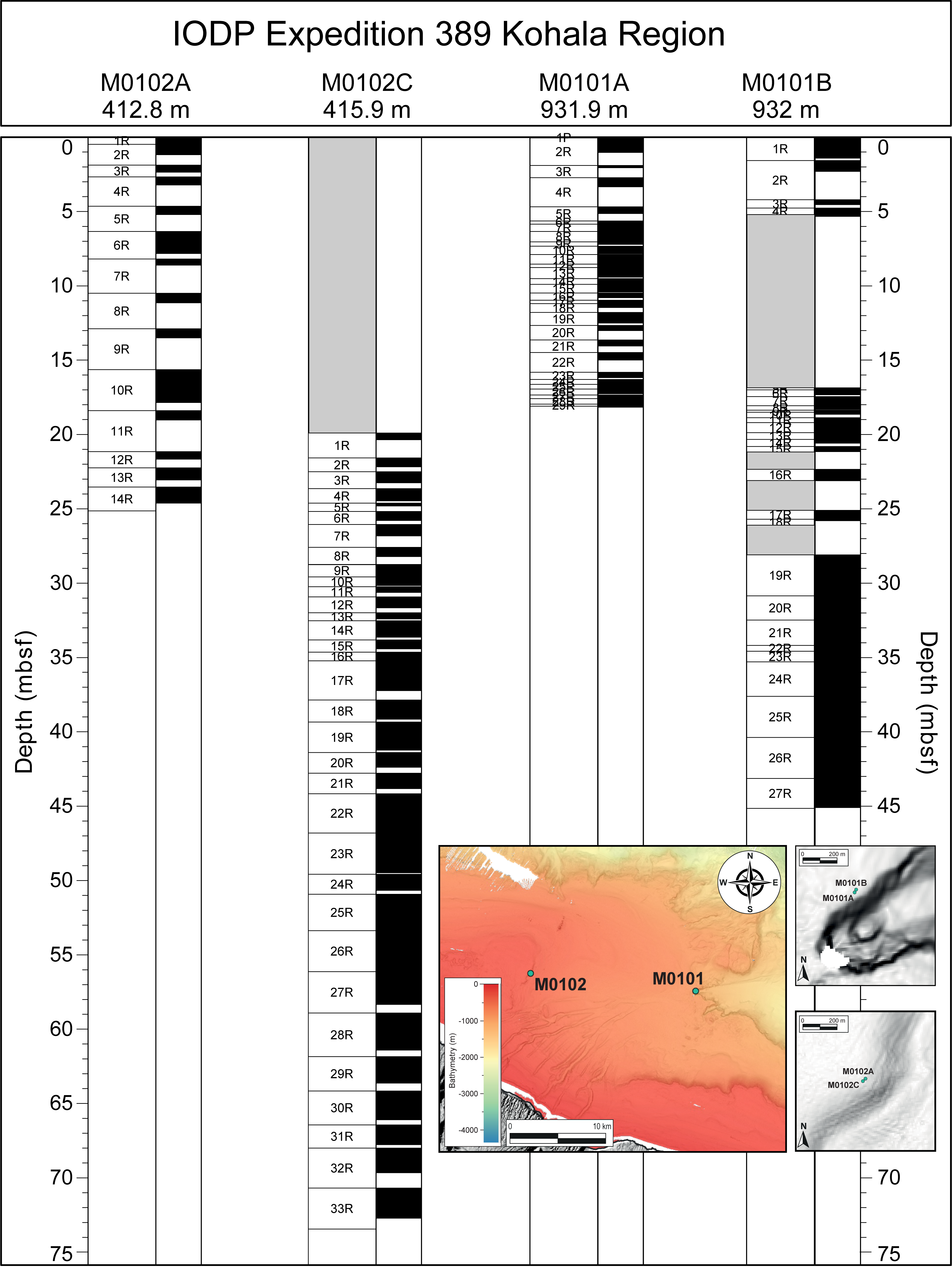
Figure F18. Kohala region cores and recovery.
The MSCL NGR, density, magnetic susceptibility, and L* data from Site M0101 show notable downhole trends that reflect the transition from reef material above to basalt below. Relative to the reef lithologies, the lava has lower L* and NGR and higher density and magnetic susceptibility as well as notable variability that may correspond to changes in the physical properties and/or chemistry of the basalt lavas.
A total of five U-Th dates were obtained for Site M0101. One date is rejected on the basis of anomalously high 238U concentration. Replicates were run on one sample, which yielded the same date within the reported uncertainty. There is one age inversion between two samples. Overall, the dates span ~365–434 ky BP, consistent with the estimated age of the H7 terrace (Ludwig et al., 1991; Webster et al., 2009).
7.2.1.2. Site M0102
Two holes were drilled at Site M0102 at 413–416 mbsl (Figures F12, F18) (see Operations in the Site M0102 chapter [Webster et al., 2025g]). Hole M0102A was drilled from 0 to 26.07 mbsf, and M0102C was wash bored to 20 mbsf and drilled from 20 to 73.44 mbsf. Based on the main lithologic changes and discontinuity surfaces, four main lithostratigraphic intervals are identified. Interval 1 forms the major part of Hole M0102A (0–22.25 mbsf) and consists of rhodoliths embedded in unconsolidated biodetrital-volcaniclastic sediment. The basal boundary of Interval 1 was recovered in both Holes M0102A and M0102C. Interval 2, recovered from 22.25 to 24.61 mbsf in Hole M0102A and from 21.58 to 28.85 mbsf in Hole M0102C, is dominated by coralgal boundstone with submassive to massive Porites. At its base, it is bounded by a thin layer of biodetrital, coarse-grained grainstone to rudstone. Interval 3 is a succession of coralgal-microbialite boundstone from 29.25 to 70.69 mbsf in Hole M0102C (not drilled in Hole M0102A), with coral morphologies changing downward from branching and platy Porites and columnar Pavona to predominantly very large massive Porites with rare laminar Pavona. Interval 4, from 70.69 to 72.71 mbsf in Hole M0102C (not drilled in Hole M0102A), consists of coralgal boundstone with abundant branching and platy Porites.
The MSCL NGR, density, magnetic susceptibility, and L* data at Site M0102 do not have any apparent downhole trends, although there is a notable downhole increase in the range of values in all these parameters within Interval 3 below about 40 mbsf.
Five U-Th dates were measured on samples from Site M0102; they span ~171–225 ky BP. None of these dates was rejected on the basis of the U-Th geochemistry; however, there is one age inversion near the bottom of Hole M0102C. Overall, the dates from Site M0102 are consistent with the timing of development of the H2 terrace spanning MIS 6/7 from Webster et al. (2009).
7.2.2. Hilo sites
Three sites (M0103–M0105) were drilled off shore Hilo on the east side of Hawai’i (Figure F13). Submersible dive observations and samples confirm that the targeted features are coral reefs that likely span MISs 1–5 and 6–7 (Puga-Bernabéu et al., 2016). Site M0103 targeted the ~400 mbsl reef (H2d), which was also cored at Kawaihae (Site M0097) and Kohala (Site M0102). Site M0104 was drilled at a shallower water depth of 347 mbsl (H2c) where high backscatter was mapped and carbonate mounds (pinnacles) were described (Puga-Bernabéu et al., 2016). Finally, Site M0105 was drilled upslope from Site M0104 on a subterrace at 340 mbsl (H2b).
7.2.2.1. Site M0103
Site M0103 consists of one hole (M0103A) located at 405 mbsl (Figures F13, F19) (see Operations in the Site M0103 chapter [Webster et al., 2025h]). Core material consists predominantly of pebble- to cobble-sized rhodoliths in the uppermost 26.60 m of the hole. The lower interval, below 26.60 mbsf, is mostly composed of unconsolidated biodetrital sediment with foliaceous corals, including Leptoseris, to 37.60 mbsf, overlying up to cobble-sized fragments of massive Porites. At 42.20 mbsf, a contact with basalt breccia was recovered, and this breccia interval continues to the bottom of the hole at 44.78 mbsf.
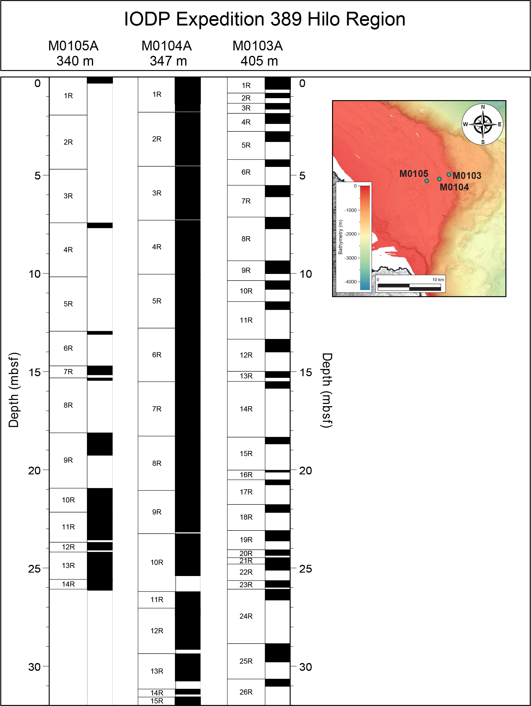
Figure F19. Hilo region site cores and recovery.
The poor recovery for Hole M0103 makes it difficult to detect downhole trends in the physical properties data. However, there is a notable peak in magnetic susceptibility at the lithologic boundary at 26.60 mbsf, and there is variability in the L* values that may correspond to changes in lithology (e.g., rhodolith rudstone/floatstone to algal boundstone).
Four U-Th dates were obtained from Hole M0103A; they span ~138–216 ky BP. The dates are in stratigraphic order and are consistent with the interpretation of the age of the H2 terrace spanning MISs 6 and 7 (Ludwig et al., 1991; Webster et al., 2009).
7.2.2.2. Site M0104
Site M0104 consists of one hole located at 347 mbsl (Figures F13, F19) (see Operations in the Site M0104 chapter [Webster et al., 2025i]). Hole M0104A spans 0–46.15 mbsf, and based on the main lithologic changes, discontinuity surfaces, and/or changes in physical properties, five main lithostratigraphic intervals are identified. Interval 1 (0–0.80 mbsf) comprises biodetrital grainstone to rudstone and is bounded at its base by a major facies change and by a change in physical properties. Interval 2 comprises the largest part of the hole and consists predominantly of coralgal-microbial boundstone from 0.80 to 31.81 mbsf with thin sections of microbial-algal boundstone and algal boundstone. The base of this interval is a blackened, hardened, and bioeroded surface with a sharp change in physical properties. Interval 3 (31.81–39.87 mbsf) comprises biodetrital grainstone and algal boundstone (with some coralgal boundstone) and is bounded at its base by a major facies change and a change in physical properties. The base of this interval is a heavily bioeroded surface. Interval 4 (39.87–43.39 mbsf) is heterogeneous and is composed of coralgal boundstone, algal boundstone, and biodetrital grainstone. At its base, magnetic susceptibility increases. Interval 5 (43.39–46.15 mbsf) is also heterogeneous and is composed of coralgal boundstone, biodetrital grainstone, and algal boundstone.
The boundaries between lithologic intervals have marked changes in physical properties: a decrease in magnetic susceptibility and an increase in L* values at the base of Interval 1, a trend from dominantly high L* values to more variable L* values within Interval 2 and a striking increase in magnetic susceptibility values from about 20 mbsf to the highest values at the base of Interval 2, relatively low magnetic susceptibility values in Interval 3, relatively low magnetic susceptibility and relatively high and less variable L* values in Interval 4, and the aforementioned slight increase in magnetic susceptibility values in Interval 5.
A total of three U-Th dates were obtained from corals from Hole M0104A; they span ~130–159 ky BP with no stratigraphic age reversals. These dates are consistent with the estimated age of the H2 terrace spanning MIS 6/7 (Ludwig et al., 1991; Webster et al., 2009).
7.2.2.3. Site M0105
Site M0105 consists of one hole located at 340 mbsl (Figures F13, F19) (see Operations in the Site M0105 chapter [Webster et al., 2025j]). Based on the main lithologic changes, Hole M0105A is divided into four main intervals. Because of poor recovery, the vertical extent and the boundaries of these intervals are unknown. The top interval is composed of rhodoliths in a dark gray unconsolidated biodetrital and volcaniclastic sandy matrix, and the second interval is represented by an algal boundstone at around 7.5 mbsf. The third interval (7.69–12.95 mbsf) is dominated by a fragmented coralgal boundstone (predominantly columnar and robust branching Porites) embedded in unconsolidated biodetrital background sediments. The fourth interval represents lava flows and basalt clinker, most commonly produced on the top and leading edge of ‘a‘a lava flows, much of which is fresh and unaltered, although zones of fracturing and alteration occur locally.
In the upper three intervals of reef material, poor recovery makes it difficult to detect downhole trends in the physical properties data. However, there are notable changes in the MSCL and L* data that reflect the transition from reef material above to basalt below. Relative to the reef lithologies, the basalt has lower L* and higher density and magnetic susceptibility, notable variability that may correspond to changes in the physical properties and/or chemistry of the basalts.
There are two U-Th dates for Hole M0105A, both ~132 ky BP, consistent with the previously-inferred timing of formation of the H2 terrace spanning MIS 6/7 (Webster et al., 2009; Puga-Bernabéu et al., 2016).
7.2.3. Ka Lae site
Because of the denial of permit applications to sample the H1d reef in Hawaiian state waters at any of the planned locations on the leeward (Kawaihae and Kona) and windward (Hilo) sides, a request was made and permission received from the IODP Site Survey Panel and EPSP to add a site on the H1d reef in the Ka Lae region (South Point). This was the only location available to drill on the H1d reef on the windward side of Hawai’i that was located in federal waters (Figure F14). The site survey data at Ka Lae is limited. To select the drilling location of Site M0106, we used the available bathymetric data and the information from two HURL submersible dives (P5-77 and P5-78), including images, pilot logs, and descriptions and locations of collected carbonate rocks (see Webster et al. [2004] for references).
7.2.3.1. Site M0106
Two holes were drilled to ~16 mbsf at Site M0106 (Holes M0102A and M0102B) at ~148 mbsl (Figures F14, F20) (see Operations in the Site M0106 chapter [Webster et al., 2025k]). Core material recovered from Site M0106 consists mostly of loose rhodoliths with crustose and fruticose coralline algal crusts down to 11.50 mbsf. Below this depth in Hole M0106B, a 1.30 m interval of unconsolidated biodetrital sediment contains pebble-sized rhodoliths and coral clasts in a finer bioclastic matrix that overlies a coralgal boundstone with massive Porites.
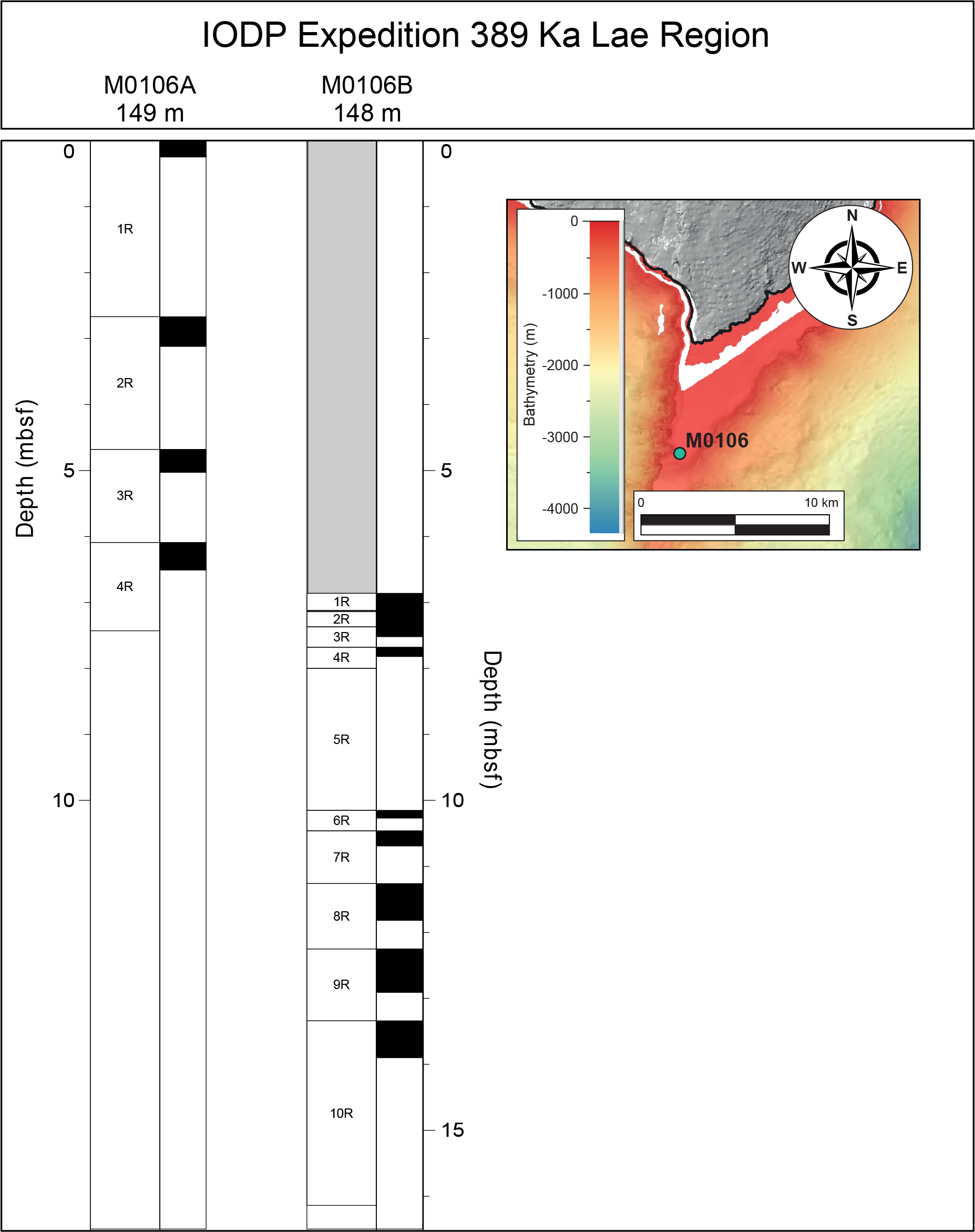
Figure F20. Ka Lae region cores and recovery.
The poor recovery at Site M0106 makes it difficult to detect downhole trends in the physical properties data. However, there is a notable increase in the L* values that may correspond to changes in lithology at 11.50 mbsf from rhodolith-rich facies to coralgal boundstone.
Two radiocarbon dates were obtained from Site M0106; they span 27–35 14C ky BP. These dates are consistent with the interpretation of the age of the H1 terrace spanning MISs 1–5 (Webster et al., 2009; Ludwig et al., 1991).
8. Geochemistry
A total of 16 surface seawater samples were collected during the offshore phase of Expedition 389, one at each of the 15 drill sites and an additional sample at Site M0099, using an improvised sampling device or a 2L Niskin bottle. Parameters including (some or all) salinity, pH, alkalinity, and ammonium concentrations were analyzed off shore, and major cations and anions were measured during the OSP (Table T2; see Table T18 in the Expedition 389 methods chapter [Webster et al., 2025a]). Results for all parameters fall within the expected ranges for surface seawater.
A total of 41 interstitial water samples were collected from all intervals with sufficient undisturbed soft sediment using Rhizon samplers during the offshore phase of Expedition 389. Of these, only 36 samples had sufficient water volume for further measurements to be made: 2 samples from Site M0099, 14 from Site M0101, 14 from Site M0102, 3 from Site M0103, 2 from Site M0105, and 1 from Site M0109. Parameters including salinity, pH, alkalinity, and ammonium concentrations were analyzed off shore, and major cations and anions were measured during the OSP, although not all parameters were measured on each interstitial water sample. Downhole trends are only apparent at Sites M0101 and M0102, where most of the measurements were made. At Site M0101, there are notable downhole trends in sulfate, strontium, manganese, chloride, and barium. At Site M0102, there are downhole trends in pH and ammonium, calcium, strontium, and silicate. Future work may identify the processes responsible for these downhole trends.
Rock and sediment samples from all sites were taken during the OSP for IODP standard measurements. In total, 144 samples were analyzed for bulk composition using energy dispersive X-Ray fluorescence (ED-XRF). In addition, splits of those samples were analyzed for total carbon (TC) and total organic carbon (TOC) using a carbon-sulfur analyzer, and total inorganic carbon (TIC) was calculated as the difference between TC and TOC. The set of 144 samples comprises 3 from Site M0096, 31 from Site M0097, 3 from Site M0098, 22 from Site M0099, 1 from Site M0100, 10 from Site M0101, 14 from Site M0102, 6 from Site M0103, 9 from Site M0104, 2 from Site M0105, 2 from Site M0106, 2 from Site M0107, 4 from Site M0108, and 5 from Site M0110. Because of the short length of the core, no bulk samples for geochemistry were taken from Site M0109.
The bulk composition results primarily reflect the large differences between bioclastic and fossil reef samples compared to samples from lava intervals. As such, the sites at which basalt was recovered (M0096, M0099–M0101, M0105, M0107, and M0110) have a large range of bulk compositions exemplified by the contrast between relatively high concentrations of calcium in the bioclastic and fossil reef facies samples compared to the relatively low concentrations of calcium and high concentrations of aluminum, iron, manganese, and silica in the basalt samples. The bulk geochemical data can be used to divide the carbonate facies samples into two groups characterized by their location on the leeward versus windward sides of Hawai’i. Aluminum, iron, manganese, and silica concentrations are below detection limit in the carbonate facies samples from all the leeward/dry sites and some of the windward sites, but these elements have modest to moderate concentrations, relative to pure basalt samples, in carbonate facies samples from several of the windward/wet sites (M0101, M0102, and M0104).
As expected, the TC and TOC weight percent values primarily reflect large differences between samples from carbonate facies compared to samples from lava intervals. There is some variability within the data from carbonate facies samples, with typical values ranging 11–12 wt% TC and 0.1–0.2 wt% TOC.
9. Paleomagnetism
Approximately one plug sample per core section, and in a few cases sediment cubes, were obtained from all sites except for Sites M0108 and M0109 during the OSP, for a total of 308 samples (301 plugs and 7 cubes). The lack of cohesive material because of drilling disturbance prevented paleomagnetic sampling for Sites M0108 and M0109. Measurements of low-field and mass-specific magnetic susceptibility (χ) were carried out for all samples. Natural remanent magnetization (NRM) was measured for all plug samples, as well as remanence following stepwise alternating field (AF) demagnetization up to a peak AF of 20 mT and for lava samples up to 100 mT. The samples are from two main lithologies: reef carbonates and volcanic rocks. Seven sediment cubes consist of bioclastic sand. A total of 227 samples are carbonate, and the remaining 74 are lava.
Across all Expedition 389 sites, χ values range −2.73 × 10⁻⁸ to 1.31 × 10⁻⁴ m3/kg and initial NRM intensity values range −2.64 × 10⁻⁸ to 6.54 × 101 A/m. This range generally reflects the differences in lithology, with lavas (basalts) having higher χ values and higher NRM intensity values compared to carbonates. These differences are clearly seen in data from Sites M0096, M0097, M0099, M0101, M0102, M0105, and M0110, where both carbonate and lava samples were analyzed. To get an idea of end-member values, sites where only lava samples were analyzed can be compared to sites where only carbonate samples were measured; sites with only lava samples (Sites M0100 and M0107) have an arithmetic mean χ value of 7.07 × 10⁻⁶ m3/kg and an arithmetic mean initial NRM value of 7.36 A/m, compared to sites with only carbonate samples (Sites M0097, M0098, M0103, M0104, and M0106), which have an arithmetic mean χ value of 1.53 × 10⁻⁷ m3/kg and an arithmetic mean initial NRM value of 2.19 × 10⁻² A/m.
Visual inspection of the data indicates that χ values covary with initial NRM values at most sites in both carbonate and volcanic intervals, suggesting that concentration of magnetic particles may drive downhole variations in both parameters. However, there are exceptions in some carbonate intervals where no covariance is apparent, probably as an artifact of very low mineral concentrations. In addition, data from Hole M0110B show that χ does not co-vary with initial NRM, possibly reflecting changes in magnetic grain size.
There are site-to-site differences in χ values measured within carbonate samples that may reflect differences in the contribution and incorporation of volcanic sediment into the reef facies. This is apparent when comparing measurements of carbonate samples from the windward/wet Sites M0101–M0103 to the leeward/dry Sites M0097–M0110: the carbonate samples from the windward/wet sites have an arithmetic mean χ value up to 2.05 × 10⁻⁶ m3/kg, approximately two orders of magnitude higher than the maximum χ values from carbonate samples from the leeward/dry sites.
10. Preliminary scientific assessment
10.1. Objective 1: to define the nature of sea level change in the central Pacific over the last 500 ky
We aim to reconstruct the most complete and detailed sea level record from fossil corals, particularly into, during, and out of the glacial periods. These data will allow more detailed testing of the sensitivity and vulnerability of ice sheet responses to orbital to millennial-scale climate change. A sea level curve will be built using absolute radiometric dating (14C AMS <50 ka and U/Th) of in situ coralgal material and paleowater depth data and published and directly calculated subsidence rates for Hawai’i.
The offshore phase successfully recovered cores from the succession of fossil reef terraces (H1, H2, H4, H6–H8, and H12) between 130 and 1240 mbsl. Initial observations of the 340 m of fossil reef cores and reconnaissance radiometric dating reveal that the archives span the past 500,000 y. The preliminary data also suggest sequences indicative of reef growth and demise during numerous periods of major ice sheet and sea level instability (e.g., MIS 12–11, MIS 10–9, MIS 7–5, MIS 3, and MIS 2–1) were recovered. During the OSP, high-quality fossil coralgal samples, consistent with shallow, high-energy settings, were taken for dating and sea level change investigations, the results of which are expected to contribute to Objective 1.
10.2. Objective 2: to reconstruct paleoclimate variability for the last 500 ky and establish the relationship between the mean climate state and seasonal–interannual variability
We aim to use coral-derived temperature and precipitation records to investigate how high-latitude climate (e.g., ice sheet size), atmospheric CO2 levels, and mean and seasonal solar radiation impact Hawaiian climate including storminess and the position of the Intertropical Convergence Zone. In combination with theoretical studies of subtropical climate change, these records will allow for the identification and study of critical processes that determine Pacific-wide climate.
The offshore phase successfully recovered massive, submassive, and columnar Porites spp. coral colonies that are potentially suitable for paleoclimate studies. Most of the specimens that can be used for monthly-resolution, multidecadal paleoclimate reconstructions are from the H1 and H2 terraces; preliminary dates indicate these samples are probably from MISs 2, 3, 6, and 7. There is also a high abundance of smaller specimens that represent <15 y of growth found throughout the recovered reef sections. During the OSP, >200 samples were taken for paleoclimate analyses. Overall, preliminary assessment of the quality and possible ages of the suite of coral specimens recovered during Expedition 389 suggest they grew during past periods with a wide dynamic range of climate forcing boundary conditions and thus will contribute to Objective 2.
10.3. Objective 3: to establish the geologic and biological response of coral reef systems to abrupt sea level and climate changes
We aim to reconstruct the detailed stratigraphic, geomorphic, and paleoenvironmental evolution of each reef in response to abrupt sea level and climate changes; test ecological theories about coral reef resilience and vulnerability to past and future climate changes by assessing the nature and rate of change in reef communities within and between successive reefs over interglacial–millennial timescales; and establish the nature of living and ancient microbial communities in the reefs and their role in reef building.
The offshore phase successfully recovered cores from fossil reef terraces at a range of water depths and ages from five different geographic areas around the island, representing both the leeward/dry and windward/wet sides of Hawai’i. Therefore, analyses of samples taken during the OSP will be interpreted in a broad spatial-temporal context, which will allow a rich understanding of the development of the Hawaiian reef system in response to major environmental changes over the past 500 ky. Preliminary observations of the cores confirm a diverse suite of lithologies and facies (mixtures of coralgal material, microbialite, and sediments) representing various shallow to deep depositional reefs settings, as well the numerous, major lithologic boundaries indicating repeated reef initiation and demise (i.e. likely subaerial exposure and drowning) that when investigated further will contribute to Objective 3.
10.4. Objective 4: to elucidate the subsidence and volcanic history of Hawai’i
We aim to refine the variation through space and time of the subsidence of Hawai’i and contribute to understanding the volcanic evolution of the island. The key to this objective is to obtain well-dated volcanic samples from the base of each hole and interbedded within or draping over the reefs.
During the offshore phase, volcanic eruption products were recovered from numerous sites and from all geographic areas studied except for Ka Lae. These volcanic products, primarily lava flows, were found on top of, within (interbedded), and beneath the reef terraces sampled during the expedition. These materials are sufficient to deduce eruption conditions (subaerial, littoral, and submarine) and deposit distance from volcanic vents. Given the preliminary ages of associated reef material, these lava flows likely date to a time period that is not well represented on the island of Hawai’i and will therefore be critical for reconstructing the Late Pleistocene geological history of Hawai’i.
References
Berger, A., and Loutre, M.F., 1991. Insolation values for the climate of the last 10 million years. Quaternary Science Reviews, 10(4):297–317. https://doi.org/10.1016/0277-3791(91)90033-Q
Campbell, J.F., 1986. Subsidence rates for the Southeastern Hawaiian Islands determined from submerged terraces. Geo-Marine Letters, 6(3):139–146. https://doi.org/10.1007/BF02238084
Chappell, J., 2002. Sea level changes forced ice breakouts in the Last Glacial cycle: new results from coral terraces. Quaternary Science Reviews, 21(10):1229–1240. https://doi.org/10.1016/S0277-3791(01)00141-X
Clague, D.A., Reynolds, J. R., Maher, N., Hatcher, G., Danforth, W., and Gardner, J. V., 1998. High-resolution Simrad EM300 Multibeam surveys near the Hawaiian Islands: canyons, reefs, and landslides. Eos, Transactions of the American Geophysical Union, 79:F826.
Clague, D.A., and Moore, J.G., 1991. Geology and petrology of Mahukona Volcano, Hawaii. Bulletin of Volcanology, 53(3):159–172. https://doi.org/10.1007/BF00301227
Dai, A., Fyfe, J.C., Xie, S.-P., and Dai, X., 2015. Decadal modulation of global surface temperature by internal climate variability. Nature Climate Change, 5(6):555–559. https://doi.org/10.1038/nclimate2605
Dartnell, P., and Gardiner, J.V., 1999. Sea-floor images and data from multibeam surveys in San Francisco Bay, Southern California, Hawaii, the Gulf of Mexico, and Lake Tahoe, California-Nevada. U.S. Geological Survey. Data Series. https://doi.org/10.3133/ds55
Galewsky, J., Silver, E.A., Gallup, C.D., Edwards, R.L., and Potts, D.C., 1996. Foredeep tectonics and carbonate platform dynamics in the Huon Gulf, Papua New Guinea. Geology, 24(9):819–822. https://doi.org/10.1130/0091-7613(1996)024<0819:FTACPD>2.3.CO;2
Hibbert, F.D., Rohling, E.J., Dutton, A., Williams, F.H., Chutcharavan, P.M., Zhao, C., and Tamisiea, M.E., 2016. Coral indicators of past sea-level change: a global repository of U-series dated benchmarks. Quaternary Science Reviews, 145:1–56. https://doi.org/10.1016/j.quascirev.2016.04.019
Humblet, M., and Webster, J.M., 2017. Coral community changes in the Great Barrier Reef in response to major environmental changes over glacial-interglacial timescales. Palaeogeography, Palaeoclimatology, Palaeoecology, 472:216–235. https://doi.org/10.1016/j.palaeo.2017.02.003
Imbrie, J., Hays, J.D., Martinson, D.G., McIntyre, A., Mix, A.C., Morley, J.J., Pisias, N.G., Prell, W.L., and Shackleton, N.J., 1984. The orbital theory of Pleistocene climate: support from a revised chronology of the marine δ18O record. Proceedings of the NATO Advanced Research Workshop, 1984:269. https://ui.adsabs.harvard.edu/abs/1984mcur.conf.269I
Kavanaugh, M.T., Church, M.J., Davis, C.O., Karl, D.M., Letelier, R.M., and Doney, S.C., 2018. ALOHA from the edge: reconciling three decades of in situ Eulerian observations and geographic variability in the North Pacific subtropical gyre. Frontiers in Marine Science, 5. https://doi.org/10.3389/fmars.2018.00130
Köhler, P., Knorr, G., Stap, L.B., Ganopolski, A., de Boer, B., van de Wal, R.S.W., Barker, S., and Rüpke, L.H., 2018. The effect of obliquity-driven changes on paleoclimate sensitivity during the Late Pleistocene. Geophysical Research Letters, 45(13):6661–6671. https://doi.org/10.1029/2018GL077717
Lambeck, K., and Chappell, J., 2001. Sea level change through the last glacial cycle. Science, 292(5517):679–686. https://doi.org/10.1126/science.1059549
Lambeck, K., Esat, T.M., and Potter, E.-K., 2002. Links between climate and sea levels for the past three million years. Nature, 419(6903):199–206. https://doi.org/10.1038/nature01089
Lea, D.W., Martin, P.A., Pak, D.K., and Spero, H.J., 2002. Reconstructing a 350 ky history of sea level using planktonic Mg/Ca and oxygen isotope records from a Cocos Ridge core. Quaternary Science Reviews, 21(1):283–293. https://doi.org/10.1016/S0277-3791(01)00081-6
Ludwig, K.R., Szabo, B.J., Moore, J.G., and Simmons, K.R., 1991. Crustal subsidence rate off Hawaii determined from 234U/238U ages of drowned coral reefs. Geology, 19(2):171–174. https://doi.org/10.1130/0091-7613(1991)019<0171:CSROHD>2.3.CO;2
MBARI Mapping Team, 2000. MBARI Hawaii Multibeam Survey, Digital Series No. 2. Monterey Bay Aquarium Research Institute. https://www3.mbari.org/data/mapping/hawaii/index.htm
Moore, J.G., and Clague, D.A., 1992. Volcano growth and evolution of the island of Hawaii. Geological Society of America Bulletin, 104(11):1471–1484. https://doi.org/10.1130/0016-7606(1992)104%3C1471:VGAEOT%3E2.3.CO;2
Moore, J.G., and Fornari, D.J., 1984. Drowned reefs as indicators of the rate of subsidence of the Island of Hawaii. The Journal of Geology, 92(6):752–759. https://doi.org/10.1086/628910
Offshore staff, 2022. Benthic introduces new portable, remotely operated drill. Offshore, 21 April 2022.https://www.offshore-mag.com/business-briefs/equipment-engineering/article/14275278/benthic-introduces-new-portable-remotely-operated-drill
Puga-Bernabéu, Á., Webster, J.M., Braga, J.C., Clague, D.A., Dutton, A., Eggins, S., Fallon, S., Jacobsen, G., Paduan, J.B., and Potts, D.C., 2016. Morphology and evolution of drowned carbonate terraces during the last two interglacial cycles, off Hilo, NE Hawaii. Marine Geology, 371:57–81. https://doi.org/10.1016/j.margeo.2015.10.016
Sanborn, K.L., Webster, J.M., Yokoyama, Y., Dutton, A., Braga, J.C., Clague, D.A., Paduan, J.B., Wagner, D., Rooney, J.J., and Hansen, J.R., 2017. New evidence of Hawaiian coral reef drowning in response to meltwater pulse-1A. Quaternary Science Reviews, 175:60–72. https://doi.org/10.1016/j.quascirev.2017.08.022
Schellmann, G., and Radtke, U., 2004. A revised morpho- and chronostratigraphy of the Late and Middle Pleistocene coral reef terraces on Southern Barbados (West Indies). Earth-Science Reviews, 64(3):157–187. https://doi.org/10.1016/S0012-8252(03)00043-6
Smith, J.R., Satake, K., and Suyehiro, K., 2002. Deepwater multibeam sonar surveys along the southeastern Hawaiian ridge: guide to the CD-ROM. In Takahashi, E., Lipman, P.W., Garcia, M.O, Naka, J., and Aramaki, S. (Eds.), Hawaiian Volcanoes: Deep Underwater Perspectives. Geophysical Monography, 128: 3–9. https://doi.org/10.1029/GM128p0003
Taylor, B., 2019. Shoreline slope breaks revise understanding of Hawaiian shield volcanoes evolution. Geochemistry, Geophysics, Geosystems, 20(8):4025–4045. https://doi.org/10.1029/2019GC008436
Thompson, W.G., and Goldstein, S.L., 2005. Open-system coral ages reveal persistent suborbital sea-level cycles. Science, 308(5720):401–404. https://doi.org/10.1126/science.1104035
Watts, A.B., 1978. An analysis of isostasy in the world’s oceans, 1. Hawaiian-Emperor Seamount Chain. Journal of Geophysical Research: Solid Earth, 83(B12):5989–6004. https://doi.org/10.1029/JB083iB12p05989
Webster, J.M., Ravelo, A.C., and Grant, H.L.J., 2023. Expedition 389 Scientific Prospectus: Hawaiian Drowned Reefs. International Ocean Discovery Program. https://doi.org/10.14379/iodp.sp.389.2023
Webster, J.M., Braga, J.C., Clague, D.A., Gallup, C., Hein, J.R., Potts, D.C., Renema, W., Riding, R., Riker-Coleman, K., Silver, E., and Wallace, L.M., 2009. Coral reef evolution on rapidly subsiding margins. Global and Planetary Change, 66(1–2):129–148. https://doi.org/10.1016/j.gloplacha.2008.07.010
Webster, J.M., Clague, D.A., Riker-Coleman, K., Gallup, C., Braga, J.C., Potts, D., Moore, J.G., Winterer, E.L., and Paull, C.K., 2004. Drowning of the -150m reef off Hawaii: a casualty of global meltwater pulse 1A? Geology, 32(3):249–252. https://doi.org/10.1130/G20170.1
Webster, J.M., and Davies, P.J., 2003. Coral variation in two deep drill cores: significance for the Pleistocene development of the Great Barrier Reef. Sedimentary Geology, 159(1–2):61–80. https://doi.org/10.1016/S0037-0738(03)00095-2
Webster, J.M., Ravelo, A.C., Grant, H.L.J., Rydzy, M., Stewart, M., Allison, N., Asami, R., Boston, B., Braga, J.C., Brenner, L., Chen, X., Chutcharavan, P., Dutton, A., Felis, T., Fukuyo, N., Gischler, E., Greve, S., Hagen, A., Hamon, Y., Hathorne, E., Humblet, M., Jorry, S., Khanna, P., Le Ber, E., McGregor, H., Mortlock, R., Nohl, T., Potts, D., Prohaska, A., Prouty, N., Renema, W., Rubin, K.H., Westphal, H., and Yokoyama, Y., 2025a. Expedition 389 methods. In Webster, J.M., Ravelo, A.C., Grant, H.L.J., and the Expedition 389 Scientists, Hawaiian Drowned Reefs. Proceedings of the International Ocean Discovery Program, 389: College Station, TX (International Ocean Discovery Program). https://doi.org/10.14379/iodp.proc.389.102.2025
Webster, J.M., Ravelo, A.C., Grant, H.L.J., Rydzy, M., Stewart, M., Allison, N., Asami, R., Boston, B., Braga, J.C., Brenner, L., Chen, X., Chutcharavan, P., Dutton, A., Felis, T., Fukuyo, N., Gischler, E., Greve, S., Hagen, A., Hamon, Y., Hathorne, E., Humblet, M., Jorry, S., Khanna, P., Le Ber, E., McGregor, H., Mortlock, R., Nohl, T., Potts, D., Prohaska, A., Prouty, N., Renema, W., Rubin, K.H., Westphal, H., and Yokoyama, Y., 2025b. Site M0096. In Webster, J.M., Ravelo, A.C., Grant, H.L.J., and the Expedition 389 Scientists, Hawaiian Drowned Reefs. Proceedings of the International Ocean Discovery Program, 389: College Station, TX (International Ocean Discovery Program). https://doi.org/10.14379/iodp.proc.389.103.2025
Webster, J.M., Ravelo, A.C., Grant, H.L.J., Rydzy, M., Stewart, M., Allison, N., Asami, R., Boston, B., Braga, J.C., Brenner, L., Chen, X., Chutcharavan, P., Dutton, A., Felis, T., Fukuyo, N., Gischler, E., Greve, S., Hagen, A., Hamon, Y., Hathorne, E., Humblet, M., Jorry, S., Khanna, P., Le Ber, E., McGregor, H., Mortlock, R., Nohl, T., Potts, D., Prohaska, A., Prouty, N., Renema, W., Rubin, K.H., Westphal, H., and Yokoyama, Y., 2025c. Site M0097. In Webster, J.M., Ravelo, A.C., Grant, H.L.J., and the Expedition 389 Scientists, Hawaiian Drowned Reefs. Proceedings of the International Ocean Discovery Program, 389: College Station, TX (International Ocean Discovery Program). https://doi.org/10.14379/iodp.proc.389.104.2025
Webster, J.M., Ravelo, A.C., Grant, H.L.J., Rydzy, M., Stewart, M., Allison, N., Asami, R., Boston, B., Braga, J.C., Brenner, L., Chen, X., Chutcharavan, P., Dutton, A., Felis, T., Fukuyo, N., Gischler, E., Greve, S., Hagen, A., Hamon, Y., Hathorne, E., Humblet, M., Jorry, S., Khanna, P., Le Ber, E., McGregor, H., Mortlock, R., Nohl, T., Potts, D., Prohaska, A., Prouty, N., Renema, W., Rubin, K.H., Westphal, H., and Yokoyama, Y., 2025d. Site M0098. In Webster, J.M., Ravelo, A.C., Grant, H.L.J., and the Expedition 389 Scientists, Hawaiian Drowned Reefs. Proceedings of the International Ocean Discovery Program, 389: College Station, TX (International Ocean Discovery Program). https://doi.org/10.14379/iodp.proc.389.105.2025
Webster, J.M., Ravelo, A.C., Grant, H.L.J., Rydzy, M., Stewart, M., Allison, N., Asami, R., Boston, B., Braga, J.C., Brenner, L., Chen, X., Chutcharavan, P., Dutton, A., Felis, T., Fukuyo, N., Gischler, E., Greve, S., Hagen, A., Hamon, Y., Hathorne, E., Humblet, M., Jorry, S., Khanna, P., Le Ber, E., McGregor, H., Mortlock, R., Nohl, T., Potts, D., Prohaska, A., Prouty, N., Renema, W., Rubin, K.H., Westphal, H., and Yokoyama, Y., 2025d. Site M0099. In Webster, J.M., Ravelo, A.C., Grant, H.L.J., and the Expedition 389 Scientists, Hawaiian Drowned Reefs. Proceedings of the International Ocean Discovery Program, 389: College Station, TX (International Ocean Discovery Program). https://doi.org/10.14379/iodp.proc.389.106.2025
Webster, J.M., Ravelo, A.C., Grant, H.L.J., Rydzy, M., Stewart, M., Allison, N., Asami, R., Boston, B., Braga, J.C., Brenner, L., Chen, X., Chutcharavan, P., Dutton, A., Felis, T., Fukuyo, N., Gischler, E., Greve, S., Hagen, A., Hamon, Y., Hathorne, E., Humblet, M., Jorry, S., Khanna, P., Le Ber, E., McGregor, H., Mortlock, R., Nohl, T., Potts, D., Prohaska, A., Prouty, N., Renema, W., Rubin, K.H., Westphal, H., and Yokoyama, Y., 2025e. Site M0100. In Webster, J.M., Ravelo, A.C., Grant, H.L.J., and the Expedition 389 Scientists, Hawaiian Drowned Reefs. Proceedings of the International Ocean Discovery Program, 389: College Station, TX (International Ocean Discovery Program). https://doi.org/10.14379/iodp.proc.389.107.2025
Webster, J.M., Ravelo, A.C., Grant, H.L.J., Rydzy, M., Stewart, M., Allison, N., Asami, R., Boston, B., Braga, J.C., Brenner, L., Chen, X., Chutcharavan, P., Dutton, A., Felis, T., Fukuyo, N., Gischler, E., Greve, S., Hagen, A., Hamon, Y., Hathorne, E., Humblet, M., Jorry, S., Khanna, P., Le Ber, E., McGregor, H., Mortlock, R., Nohl, T., Potts, D., Prohaska, A., Prouty, N., Renema, W., Rubin, K.H., Westphal, H., and Yokoyama, Y., 2025f. Site M0101. In Webster, J.M., Ravelo, A.C., Grant, H.L.J., and the Expedition 389 Scientists, Hawaiian Drowned Reefs. Proceedings of the International Ocean Discovery Program, 389: College Station, TX (International Ocean Discovery Program). https://doi.org/10.14379/iodp.proc.389.108.2025
Webster, J.M., Ravelo, A.C., Grant, H.L.J., Rydzy, M., Stewart, M., Allison, N., Asami, R., Boston, B., Braga, J.C., Brenner, L., Chen, X., Chutcharavan, P., Dutton, A., Felis, T., Fukuyo, N., Gischler, E., Greve, S., Hagen, A., Hamon, Y., Hathorne, E., Humblet, M., Jorry, S., Khanna, P., Le Ber, E., McGregor, H., Mortlock, R., Nohl, T., Potts, D., Prohaska, A., Prouty, N., Renema, W., Rubin, K.H., Westphal, H., and Yokoyama, Y., 2025g. Site M0102. In Webster, J.M., Ravelo, A.C., Grant, H.L.J., and the Expedition 389 Scientists, Hawaiian Drowned Reefs. Proceedings of the International Ocean Discovery Program, 389: College Station, TX (International Ocean Discovery Program). https://doi.org/10.14379/iodp.proc.389.109.2025
Webster, J.M., Ravelo, A.C., Grant, H.L.J., Rydzy, M., Stewart, M., Allison, N., Asami, R., Boston, B., Braga, J.C., Brenner, L., Chen, X., Chutcharavan, P., Dutton, A., Felis, T., Fukuyo, N., Gischler, E., Greve, S., Hagen, A., Hamon, Y., Hathorne, E., Humblet, M., Jorry, S., Khanna, P., Le Ber, E., McGregor, H., Mortlock, R., Nohl, T., Potts, D., Prohaska, A., Prouty, N., Renema, W., Rubin, K.H., Westphal, H., and Yokoyama, Y., 2025h. Site M0103. In Webster, J.M., Ravelo, A.C., Grant, H.L.J., and the Expedition 389 Scientists, Hawaiian Drowned Reefs. Proceedings of the International Ocean Discovery Program, 389: College Station, TX (International Ocean Discovery Program). https://doi.org/10.14379/iodp.proc.389.110.2025
Webster, J.M., Ravelo, A.C., Grant, H.L.J., Rydzy, M., Stewart, M., Allison, N., Asami, R., Boston, B., Braga, J.C., Brenner, L., Chen, X., Chutcharavan, P., Dutton, A., Felis, T., Fukuyo, N., Gischler, E., Greve, S., Hagen, A., Hamon, Y., Hathorne, E., Humblet, M., Jorry, S., Khanna, P., Le Ber, E., McGregor, H., Mortlock, R., Nohl, T., Potts, D., Prohaska, A., Prouty, N., Renema, W., Rubin, K.H., Westphal, H., and Yokoyama, Y., 2025i. Site M0104. In Webster, J.M., Ravelo, A.C., Grant, H.L.J., and the Expedition 389 Scientists, Hawaiian Drowned Reefs. Proceedings of the International Ocean Discovery Program, 389: College Station, TX (International Ocean Discovery Program). https://doi.org/10.14379/iodp.proc.389.111.2025
Webster, J.M., Ravelo, A.C., Grant, H.L.J., Rydzy, M., Stewart, M., Allison, N., Asami, R., Boston, B., Braga, J.C., Brenner, L., Chen, X., Chutcharavan, P., Dutton, A., Felis, T., Fukuyo, N., Gischler, E., Greve, S., Hagen, A., Hamon, Y., Hathorne, E., Humblet, M., Jorry, S., Khanna, P., Le Ber, E., McGregor, H., Mortlock, R., Nohl, T., Potts, D., Prohaska, A., Prouty, N., Renema, W., Rubin, K.H., Westphal, H., and Yokoyama, Y., 2025j. Site M0105. In Webster, J.M., Ravelo, A.C., Grant, H.L.J., and the Expedition 389 Scientists, Hawaiian Drowned Reefs. Proceedings of the International Ocean Discovery Program, 389: College Station, TX (International Ocean Discovery Program). https://doi.org/10.14379/iodp.proc.389.112.2025
Webster, J.M., Ravelo, A.C., Grant, H.L.J., Rydzy, M., Stewart, M., Allison, N., Asami, R., Boston, B., Braga, J.C., Brenner, L., Chen, X., Chutcharavan, P., Dutton, A., Felis, T., Fukuyo, N., Gischler, E., Greve, S., Hagen, A., Hamon, Y., Hathorne, E., Humblet, M., Jorry, S., Khanna, P., Le Ber, E., McGregor, H., Mortlock, R., Nohl, T., Potts, D., Prohaska, A., Prouty, N., Renema, W., Rubin, K.H., Westphal, H., and Yokoyama, Y., 2025k. Site M0106. In Webster, J.M., Ravelo, A.C., Grant, H.L.J., and the Expedition 389 Scientists, Hawaiian Drowned Reefs. Proceedings of the International Ocean Discovery Program, 389: College Station, TX (International Ocean Discovery Program). https://doi.org/10.14379/iodp.proc.389.113.2025
Webster, J.M., Ravelo, A.C., Grant, H.L.J., Rydzy, M., Stewart, M., Allison, N., Asami, R., Boston, B., Braga, J.C., Brenner, L., Chen, X., Chutcharavan, P., Dutton, A., Felis, T., Fukuyo, N., Gischler, E., Greve, S., Hagen, A., Hamon, Y., Hathorne, E., Humblet, M., Jorry, S., Khanna, P., Le Ber, E., McGregor, H., Mortlock, R., Nohl, T., Potts, D., Prohaska, A., Prouty, N., Renema, W., Rubin, K.H., Westphal, H., and Yokoyama, Y., 2025l. Site M0107. In Webster, J.M., Ravelo, A.C., Grant, H.L.J., and the Expedition 389 Scientists, Hawaiian Drowned Reefs. Proceedings of the International Ocean Discovery Program, 389: College Station, TX (International Ocean Discovery Program). https://doi.org/10.14379/iodp.proc.389.114.2025
Webster, J.M., Ravelo, A.C., Grant, H.L.J., Rydzy, M., Stewart, M., Allison, N., Asami, R., Boston, B., Braga, J.C., Brenner, L., Chen, X., Chutcharavan, P., Dutton, A., Felis, T., Fukuyo, N., Gischler, E., Greve, S., Hagen, A., Hamon, Y., Hathorne, E., Humblet, M., Jorry, S., Khanna, P., Le Ber, E., McGregor, H., Mortlock, R., Nohl, T., Potts, D., Prohaska, A., Prouty, N., Renema, W., Rubin, K.H., Westphal, H., and Yokoyama, Y., 2025m. Site M0108. In Webster, J.M., Ravelo, A.C., Grant, H.L.J., and the Expedition 389 Scientists, Hawaiian Drowned Reefs. Proceedings of the International Ocean Discovery Program, 389: College Station, TX (International Ocean Discovery Program). https://doi.org/10.14379/iodp.proc.389.115.2025
Webster, J.M., Ravelo, A.C., Grant, H.L.J., Rydzy, M., Stewart, M., Allison, N., Asami, R., Boston, B., Braga, J.C., Brenner, L., Chen, X., Chutcharavan, P., Dutton, A., Felis, T., Fukuyo, N., Gischler, E., Greve, S., Hagen, A., Hamon, Y., Hathorne, E., Humblet, M., Jorry, S., Khanna, P., Le Ber, E., McGregor, H., Mortlock, R., Nohl, T., Potts, D., Prohaska, A., Prouty, N., Renema, W., Rubin, K.H., Westphal, H., and Yokoyama, Y., 2025n. Site M0109. In Webster, J.M., Ravelo, A.C., Grant, H.L.J., and the Expedition 389 Scientists, Hawaiian Drowned Reefs. Proceedings of the International Ocean Discovery Program, 389: College Station, TX (International Ocean Discovery Program). https://doi.org/10.14379/iodp.proc.389.116.2025
Webster, J.M., Ravelo, A.C., Grant, H.L.J., Rydzy, M., Stewart, M., Allison, N., Asami, R., Boston, B., Braga, J.C., Brenner, L., Chen, X., Chutcharavan, P., Dutton, A., Felis, T., Fukuyo, N., Gischler, E., Greve, S., Hagen, A., Hamon, Y., Hathorne, E., Humblet, M., Jorry, S., Khanna, P., Le Ber, E., McGregor, H., Mortlock, R., Nohl, T., Potts, D., Prohaska, A., Prouty, N., Renema, W., Rubin, K.H., Westphal, H., and Yokoyama, Y., 2025o. Site M0110. In Webster, J.M., Ravelo, A.C., Grant, H.L.J., and the Expedition 389 Scientists, Hawaiian Drowned Reefs. Proceedings of the International Ocean Discovery Program, 389: College Station, TX (International Ocean Discovery Program). https://doi.org/10.14379/iodp.proc.389.117.2025
Webster, J.M., Wallace, L., Silver, E., Applegate, B., Potts, D., Braga, J.C., Riker-Coleman, K., and Gallup, C., 2004. Drowned carbonate platforms in the Huon Gulf, Papua New Guinea. Geochemistry, Geophysics, Geosystems, 5(11). https://doi.org/10.1029/2004GC000726
Webster, J.M., Wallace, L., Silver, E., Potts, D., Braga, J.C., Renema, W., Riker-Coleman, K., and Gallup, C., 2004. Coralgal composition of drowned carbonate platforms in the Huon Gulf, Papua New Guinea; implications for lowstand reef development and drowning. Marine Geology, 204(1):59–89. https://doi.org/10.1016/S0025-3227(03)00356-6
Webster, J.M., Wallace, L.M., Clague, D.A., and Braga, J.C., 2007. Numerical modeling of the growth and drowning of Hawaiian coral reefs during the last two glacial cycles (0–250 kyr). Geochemistry, Geophysics, Geosystems, 8(3):Q03011. https://doi.org/10.1029/2006GC001415
Woodroffe, C.D., and Webster, J.M., 2014. Coral reefs and sea-level change. Marine Geology, 352:248–267. https://doi.org/10.1016/j.margeo.2013.12.006
Yokoyama, Y., Esat, T.M., and Lambeck, K., 2001. Coupled climate and sea-level changes deduced from Huon Peninsula coral terraces of the last ice age. Earth and Planetary Science Letters, 193(3):579–587. https://doi.org/10.1016/S0012-821X(01)00515-5
Yokoyama, Y., Esat, T.M., Thompson, W.G., Thomas, A.L., Webster, J.M., Miyairi, Y., Sawada, C., Aze, T., Matsuzaki, H., Okuno, J., Fallon, S., Braga, J.-C., Humblet, M., Iryu, Y., Potts, D.C., Fujita, K., Suzuki, A., and Kan, H., 2018. Rapid glaciation and a two-step sea level plunge into the Last Glacial Maximum. Nature, 559(7715):603–607. https://doi.org/10.1038/s41586-018-0335-4
Yokoyama, Y., Lambeck, K., De Deckker, P., Esat, T.M., Webster, J.M., and Nakada, M., 2022. Towards solving the missing ice problem and the importance of rigorous model data comparisons. Nature Communications, 13(1):6261. https://doi.org/10.1038/s41467-022-33952-z